원앤온리PT 부산교대점
Users' Diaries
Recent diary entries
Posted by carmel4a97 on 27 August 2024 in Polish (Polski).

Zbieram informacje, gdzie zaczyna/kończy się strefa ograniczonej prędkości, bo dane są trochę przestarzałe: osm.org/note/4404285
Przy okazji, na dalszy etap, za info o ograniczeniach wagi i parkowania i “strefach zamieszkania” czy progach zwalniających też będę wdzięczny :)
Sailing today with P&E.
Forecast was for 10 knots with gusts to 18.
Easy out of the marina and then across the fjord to Nesodden. Very lumpy and heeling over. P&E learnt a new word “goffered” ie to get a wave in the face.

Кроме того, хочу поделиться еще одной радостной новостью. Наш валидатор 3D зданий наконец стал показывать ошибки (не прошло и пяти лет!)

Посмотреть можно например тут.
Так же, если так удобнее, ошибки показываются для каждого здания отдельно.
Основная и чаще всего встречающаяся ошибка – это отсутствие значения высоты (height=*) на билдинг-парте. Билдинг-парт без высоты – вещь совершенно бесполезная и отрендерена быть никак не может.
Также встречаются опечатки в roof:shape, перепутанные roof:direction и roof:orientation, а также неразборчивые даты постройки (start_date)
Так что если не знаете чем заняться – гляньте свой регион.
Новый топ-100 зданий
Когда-то давно, мы с вами рассматривали топ-100 самых проработанных 3D зданий, даже ролик про это сняли.
Прогресс не стоит на месте, и с тех пор топ значительно обновился. Во-первых, в список ворвался Челябинск, а во-вторых, рухнул казавшимся нерушимым рекорд по количеству билдинг-партов на одно здание.
Итак, приветствуем нового чемпиона: Кафедральный собор Рождества Христова в Челябинске:

Этот шедевр включает 6375 билдинг-партов. По словам автора всё делалось вручную, методом копи-пейст. Как автор с ней справился, я не представляю.
Кажется, что с подобным уровнем детализации даже отдельное текстурирование не нужно.
Предыдущий шедевр, напомню, включал 1088 частей и принадлежал мечети «Сердце Чечни» в Грозном.
Полностью с участниками топа можно познакомиться здесь: http://3dcheck.zkir.ru/rus-top.html
Posted by sangonzag on 25 August 2024 in Spanish (Español).
Last updated on 7 December 2024.

Iniciativa
Desde que conocí OpenStreetMap, me impresionó la cantidad de trabajo que ha puesto la comunidad en construir un mapa súmamente detallado del mundo, donde se muestran las particularidades de cada lugar, y donde se brinda la posibilidad de aplicar los datos para el uso de todas las personas.
En particular, el municipio donde vivo no cuenta con un mapa muy completo. La cartografía urbana está desactualizada, y nada qué decir de la rural.
Es por eso que hace un par de meses decidí iniciar la campaña de mapeo de todo el territorio, empezando por la zona rural.
Inicio del proyecto
Como he trabajado durante un par de años en la administración municipal, tengo conocimiento de la estructura geográfica del municipio. En particular, quise iniciar el proyecto de manera organizada, tomando como punto de partida la vereda número 1: Cascajo Arriba.
Primer paso: Mapeo organizado
Creación del archivo de la zona
Primero, tomé el archivo vectorial de las veredas del municipio, y exporté el polígono de la vereda en formato GeoJSON. Para esto, usé QGIS.
Creación del proyecto en el HOT Tasking Manager
Con el archivo guardado, procedí a la creación del proyecto en el HOT Tasking Manager, al cual tuve acceso gracias a la Comunidad OSM Colombia. Al proyecto le fue signada la tarea #16940.
Delimitación de la zona
Usé el archivo en formato GeoJSON para delimitar la zona de trabajo (área prioritaria) y crear 71 tareas.
Imagen de referencia
Para digitalizar los elementos del mapa (edificios, cultivos, bosques, ríos, carreteras, etc.) utilizé la ortofoto de la zona rural del municipio a través del servicio WMS disponible en Colombia en Mapas. Esta ortofoto corresponde a imágenes del año 2023, por lo que son datos muy recientes y confiables para la digitalización de elementos.
Permisos
Posted by Barro on 25 August 2024 in Finnish (Suomi).
Last updated on 26 August 2024.
Taas jatkuu yksi kesä paikkapistepuutteiden täydentämisen osalta samalla, kun tulee pyöräiltyä milloin minnekin. Työkalut itselläni tähän mikrokartoitukseen kehittyy ja optimoituu hiljalleen sen perusteella, mitä tehokkaampia tapoja ja välineitä tehdä asioita tulee löydettyä.
Laitteisto pyörän tangossa
OpenStreetMapin dataa on mahdollista päivittää mikrokartoitustasolla kahdella eri lähestymistavalla:
- Paikan päällä kentällä. Tässä yleensä on rajattu aika mitä käyttää kussakin paikassa ja siten pitää valita se, mitä kirjaa ylös ja miten. Yleensä tässä työkalut rajoittaa, sillä kentällä harvemmin on muuta käytössä kuin mobiilikäyttöjärjestelmällä varustettu kannettava laite.
- Jälkikäteen muistiinpanojen perusteella. Tässä muistiinpanovälineistö rajoittaa sitä, että millaista tietoa ja kuinka paljon saa käyttöönsä siihen, kun jälkikäteen päivitää OpenStreetMapia.
Olen valinnut päivitystavaksi tehdä asiat paikan päällä kentällä pyöräillessä ja vain poikkeustapauksissa jatkan kotona. Viimekesäiset varusteet on vaihtuneet kokonaan toisiin, tarjoten hieman paremman kokemuksen. Nämä on nähtävissä kuvasta 1.

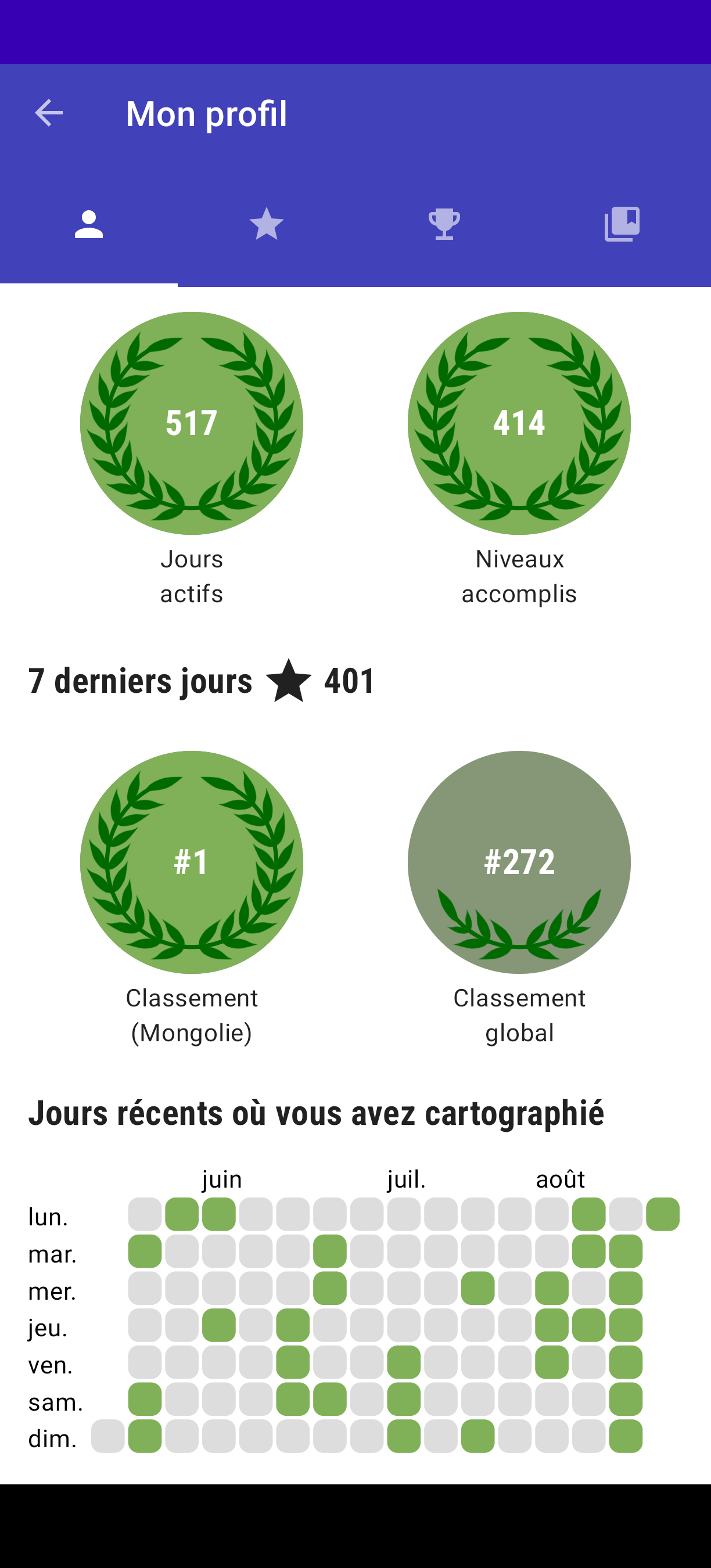
Ma femme étant mongole, je visite le pays plus ou moins régulièrement. J’ai essayé de le cartographier ou d’en ajouter des détails à chaque fois. Mais jusqu’à présent, je n’y étais pas parvenu.
Cette année j’avais prévu d’avoir de la 3/4 G tout le long de mon séjour, mais pour des raisons techniques, je me suis retrouvé en mode WIFI pour 95% du temps que j’y ai passé. J’avais donc prévu d’utiliser Vespucci et StreetComplete de manière intensive.
Comme je suis passé en mode wifi, je n’ai pu utiliser StreetComplete que dans la capitale. Cela ne m’a pas empêché de finir premier au classement :p (genre dès la première quête complétée)
Posted by Peter Koppatz on 24 August 2024 in German (Deutsch).
Ich habe eine Anwendung in der, ausgehend von den Koordinaten:
52.27070436093613 / 13.947154283564489
über Leafelet der Ort Kolpin ermittelt wurde. Genauer wäre der Ort Storkow.
Wie kann es zu dieser ungenauen Zurodnung kommen?
Posted by klfb75gxiy21tjrh on 23 August 2024 in Chinese (China) (中文(中国大陆)).


BUILDINGS ADDED BY USER ZH9567 IN OPENSTREETMAP AROUND THE KLANG VALLEY AS OF 20 AUGUST 2024
Data generated through Overpass Turbo, with all features with the tag building=* on OpenStreetMap with latest revision made by Zh9567. Note that it include buildings added by others and last updated by the user, but not include buildings added by the user and got updated by other users.
As we can see in the map, Zh9567 mapped many buildings around the Klang Valley. They are mainly concentrated in Klang, southern Shah Alam, Subang Jaya, Puchong, Seri Kembangan, Kajang, Cheras, and Ampang.
As of 20 August 2024, there are 715,932 buildings (23,987 hectares) added into OpenStreetMap in Kuala Lumpur, Putrajaya, and Selangor combined. Zh9567 has added and updated 510,000 buildings (11,007 hectares) around the region, with a total of 71% (or 45.9% if counted by hectares). And these numbers will continue to rise in the future.
This is quite a major contribution in OpenStreetMap. Let’s help improve OpenStreetMap together!
Kindly fill in our survey about knowledge and opinion of maps among Malaysians (for Malaysians only at the moment): https://docs.google.com/forms/d/e/1FAIpQLSc5KOuuNLtZAAkFU8DYO_-xjZixJVTY3NukRORiIfLtGGaQVA/viewform?usp=sf_link
Support us on Patreon: https://www.patreon.com/Zh9567
Support us on Ko-fi: https://ko-fi.com/zh9567
No, not that kind of a minister!
Anyways, at the moment, Heritage Week is on in Ireland, and I gave a talk on Monday in our new library building (on OSM) about “Citizen Science and Linked OpenData” using mostly my holy well survey as an example, but a bit the Ogham Project as well. I used one of the toilets in the library to explain how the general tagging works, because it is quite nano mapped and relatable.
The Minister for Heritage (and other things) was present and kindly posted on Facebook about it afterwards: https://www.facebook.com/MinisterMalcolmNoonan/posts/pfbid09t7ubGw1CgEN6vNZeUqTGFngepAsKsARzxiJbinr6siLtn9ovPuXdEA46spxdW8xl
Just for context, in the first photo, he’s the guy in the middle, and the elderly people are descendants of Hubert Butler (on wikipedia), they were the other VIP guests so to speak.
It’s a busy week for him, so I was pretty happy that he attended and promoted OSMin his post. (Even though we still have to work on the spelling, but at least he didn’t use the plural like so many other people.)
I talked about the Wikiverse as well, of course. Wikimedia Ireland dedicated a blog post to it beforehand as advertisement for the talk. Thanks very much for that as well!
Recently started running to work.
It is painful every morning.
But it is never regretted.
It’s been a while since I last wrote about iD’s development and thought it would be a nice idea to make this a more regular thing in addition to the regular online community chats.
Recently, there have been some new features implemented that are worth showcasing, including several great ways that community members are stepping up to contribute to iD.
iD v2.30 release

In his Google Summer of Code project, Mattia Pezzotti has implemented support for street level imagery from Panoramax. Panoramax is a relatively new completely free and open-source alternative to other street level imagery providers such as Mapillary, KartaView or Bing Streetside. It even includes features like a federated system architecture and the possibility to self-host the server software if you need to. Check the project out on panoramax.fr to read more and how to contribute your own pictures.
Posted by MarcoR on 21 August 2024 in Italian (Italiano).
Ispirato dal diario dell’utente bryceco, ecco una lista aggiornata all’11 agosto 2024 degli utenti che hanno mappato sul suolo italiano per almeno 90 giorni consecutivi:
Posted by TBesse on 20 August 2024 in German (Deutsch).
Im Lebacher Stadtteil Dörsdorf wurde schon 1791 ein Wegekreuz an der Straßenkreuzung im Ort erwähnt. Von den 1962 nachgewiesenen 9 Kreuzen sind noch 6 historische Wegekreuze erhalten geblieben (http://overpass-turbo.eu/s/1Q0F). Diese wurden nun in einer Wegekreuz-Tour vom Dorf hoch hinauf zum Gipfelkreuz/Bergkreuz auf den 439 m hohen Berg namens Krummer Stein beschrieben und in OSM kartiert. Die Infos dazu finden Sie unter http://www.besse.de/buecher/2024_Doersdorfer_Wegekreuz-Tour.pdf
Das nachstehende Foto zeigt die sechs Wegekreuze in und um das Höhendorf Dörsdorf:

Posted by Isaac Rowe on 20 August 2024 in English.
Read part 1 here.
I drive through the new RCUT intersection again today, this time making a GPS trace of my movements. I attempted to make each of the possible turns in the configuration. I did have to make one illegal maneuver, as the left turn north from Athens-Boonesboro does not go anywhere, and, while the light is installed and the turn lane unblocked, there are signs indicating that no turn is possible from that lane. The light is (as far as I can tell), in a semi-permanent red arrow state until the side road is developed. Since the turn lane is divided from the main road by a concrete island, the only way out is to make an impermissible left turn or unsafely reverse back into traffic. I chose to make the left turn. Cones or bollards are probably warranted to keep motorists from accessing the left turn lane to nowhere.
Based on this trace, I attempted to align the nodes for the separated left turn and U-turn lanes to the correct positions. Since the lane begins further back from where the dividing island begins, there is some ambiguity on when to split the lane into a separate line; I chose to break it off roughly where the dividing island begins. This makes for a less visually appealing line, but it does semantically indicate where lane changes are still technically possible.
This matches the approach I saw elsewhere on OSM, in Troy, MI. Apple Maps does the same thing (possibly with OSM data), while Bing Maps maps the entire turn lane as separate. Google Maps has a very interesting mix where one direction breaks away at the dividing island, but the other direction breaks away much further back in the turn lane. Google Street-View imagery from November 2021 shows bollards dividing the entire turn lane, so their system must’ve used that as the dividing point . Bing Maps imagery collected in April 2022 do not show these dividers.
Posted by Leaf High Harrick on 20 August 2024 in English.
Glad I found this app so I’m able to help out, as my neighborhood is very very much out of date! Many roads are missing and names are missing for many roads on the map…. Now, if I can figure out how to actually get my note to save, or how to name a road, then I’ll be in business!! hahaha.
Introduction
Another little update. I am writing these, usually, on Sundays. Since I am still a new user of OSM I am writing these as a little how are things going. I wanted to share my experiences and ideas with the greater OSM community.
Confused
I am still doing the mapping and having a super hard time in some ways. I have a disability and if the OSM community could make the program more accessible that would be helpful to a lot of folks. I am haaving a really hard time mapping and understanding what the tools do. For instance attributes like car=wheel, just took that out of the air. I am not fully understanding the relationships and how many should be tagged and if there is a standard block of them already made up for new users. If anyone has any ideas on how to understand the relationships more please feel free to let me know.
Disability and Accessibility
I know I just mentioned that I have a challenge and I am curious what the OSM community is reaching out to folks with challenges. Keep in mind I know nothing about what OSM is or has been doing to make this possible. Its a thought I had.
GitHub
No idea what github is and I am not sure if I should use it or not. I would love to learn more about it and what I can use it for and what one cannot use it for.
StreetComplete
I am having a lot of fun doing this. Its simple yet important information. I am super curious about what happens and what the data collected goes towards after a quest is completed. Its simple yet I feel I am contributing in a small simple way.
Conclusion
Its not much but some questions and thoughts this time. Have a wonderful day!
Ask
If anyone knows of any answers to my questions, or thoughts, or people I could reachout to please let me know and feel free to DM me.

Pete Masters called our attention on this new feature for communities on OpenStreetMap, so I decided to give it a try.
First thing to say is that it resulted me very confusing, not only the name -as is told in the comments of the original publication- but the sign up process too. Here are some screen captures to ilustrate the process:

This part was easy but confusing. I had to take a look at the URL to be sure I was not trying to create another OSM user. And I had my OSM user live and open in another tab.