 OpenStreetMap

試機1
Users' Diaries
Recent diary entries
Posted by christopheCD22 on 28 July 2026 in French (Français).
Bonjour, Je travaille à l’exploitation des routes départementales au Conseil Départemental des Côtes d’Armor. Afin de mener à bien nos missions, nous utilisons des application informatique dont la carto est basée sur OSM. Nous constatons de nombreuses erreur d’affectation de route. En effet de nombreux déclassement de route de route départementale vers route communale n’apparaissent pas. Nos données carto sont en open data et utilisés par l’iGN qui met donc ses cartes à jour régulièrement. Comment faire pour les cartes OSM soient le plus à jour possible. Merci
Posted by christopheCD22 on 28 July 2026 in French (Français).
Bonjour, Je travaille à l’exploitation des routes départementales au Conseil Départemental des Côtes d’Armor. Afin de mener à bien nos missions, nous utilisons des application informatique dont la carto est basée sur OSM. Nous constatons de nombreuses erreur d’affectation de route. En effet de nombreux déclassement de route de route départementale vers route communale n’apparaissent pas. Nos données carto sont en open data et utilisés par l’iGN qui met donc ses cartes à jour régulièrement. Comment faire pour les cartes OSM soient le plus à jour possible. Merci

One day, in a certain neighborhood, there was a heated discussion about naming an unnamed road.
At first, the discussion was about deciding what name they should choose for the road.
But can you guess the final consensus of that discussion?
They preferred not to be mapped.
The status quo was good enough, they said. The road looked like a maze, with little or no clue on how to properly navigate it. They argued that if they named the unnamed road, it would give “outsiders” a clue on how to navigate it, which was “bad” for the internal security of the people who lived there.
This made me think about the ethical grounds of conducting large-scale mapathon campaigns remotely.
We generally work under the assumption that “the more mapped places, the better.” But what if the locals don’t consent to being mapped?
What if they prefer not to be mapped?

Querying OpenStreetMap Data with the Overpass Turbo Wizard
If you’re new to OpenStreetMap (OSM), writing Overpass queries from scratch can seem intimidating. Fortunately, Overpass Turbo provides a built-in Wizard that generates queries automatically based on simple search phrases. This makes it easy to retrieve geographic data without learning the full Overpass Query Language (Overpass QL).
What is the Overpass Turbo Wizard?
The Wizard is a feature in Overpass Turbo that converts plain-language search terms into valid Overpass queries. Instead of manually writing code, you can describe the data you want and let the Wizard generate the query for you.
For example, if you want to find schools in the current map area, you can simply enter:
text
amenity=school
The Wizard will create the corresponding Overpass query automatically.
How to Use the Wizard
- Open Overpass Turbo.
- Zoom the map to your area of interest.
- Click Wizard in the toolbar.
- Enter a search expression such as:
amenity=hospital
or
shop=supermarket
- Click Build and Run Query.
- The matching features will appear on the map.
The generated query can also be viewed and edited if needed.
Example
Suppose you want to locate restaurants in the visible map area. Enter:
amenity=restaurant
The Wizard generates an Overpass query and displays all matching restaurants from OpenStreetMap within the current map view.
Exporting the Results
After the query runs successfully, you can export the results for use in GIS software or other applications.
- Click Export.
-
Choose a format such as:
- GeoJSON for web mapping and GIS tools.
- KML for Google Earth.
- GPX for GPS applications.
- Raw OSM Data for OpenStreetMap-based workflows.
- Save the file to your computer.
GeoJSON is the most commonly used format because it works well with tools like QGIS, Leaflet, and Mapbox.
Conclusion
I miss you

Pola Keyword SEO Spam Judi Online di Indonesia
Hasil pengamatan menunjukkan bahwa changeset SEO spam judi online di OpenStreetMap memiliki pola yang relatif konsisten. Brand umumnya menggunakan akhiran “88”, sedangkan komentar changeset berisi kumpulan kata kunci promosi yang diulang untuk kepentingan optimasi mesin pencari (SEO), bukan untuk mendeskripsikan perubahan data OpenStreetMap.
Observations indicate that SEO spam changesets related to online gambling in OpenStreetMap follow a relatively consistent pattern. Brand names commonly use the “88” suffix, while changeset comments consist of collections of promotional keywords repeated for search engine optimization (SEO) purposes rather than describing the actual OpenStreetMap data edits.
Keywords are ordered by descending frequency
Very High / Dominant Frequency
–88 (brand suffix)
slot
gacor
judi
casino
terpercaya
terbaik
High Frequency
login
daftar
link alternatif
RTP
maxwin
jackpot
bonus
deposit
withdraw
mahjong
zeus
Pragmatic Play
PG Soft
togel
toto
–77 (suffix)
–99 (suffix)
–138 (suffix)
–168 (suffix)
–188 (suffix)
–303 (suffix)
–777 (suffix)
Moderate Frequency
pola
cashback
free spin
scatter
wild
multiplier
cuan
menang
sabung ayam
SV388
poker
domino
QQ
Habanero
Joker
Spadegaming
Microgaming
Playtech
Unique Study: Trojan Horse Spam
Pada teknik ini, komentar changeset tampak sepenuhnya normal dan tidak mengandung kata kunci yang berkaitan dengan perjudian. Sebaliknya, konten spam disembunyikan di dalam tag objek OSM, sehingga deteksi yang hanya mengandalkan kata kunci pada komentar changeset menjadi kurang efektif.
In this technique, the changeset comment appears completely legitimate and contains no gambling-related keywords. Instead, the spam is concealed within the OSM object’s tags, making keyword-based changeset detection less effective.
Contoh / Example:

I’ve been mapping out every building I can that is visible from satellite imagery and Bing Streetside throughout Mount Pleasant. I’m currently focused on finishing up the neighborhoods and businesses that are on Chuck Dawley and Coleman Blvd, and I have almost finished filling in that large area made up from those major arteries.
I really wish I could use Charleston County’s GIS viewer for addresses and building shapes (especially for newer buildings, since people keep moving here ):< ), but of course the county puts all of their GIS data under copyright. That would be fine, but I tried contacting the GIS office to see if I could get permission to use their data, specifically their address data, but they never even responded. There are a few other ways that I could “request” address data but I don’t know if those requests would even be useful for mapping purposes. Best thing to do is to go to these neighborhoods myself and mark down any addresses that I couldn’t have gathered from Streetside. I’m not sure how I will do that without looking like a creep stopping at people’s houses and marking their address down. Guess I’ll have to grow a pair and do it anyway!
I do wish Bing Streetside had better image quality. The best images are from 8 years ago, and some houses have been demolished and replaced in that time according to Esri imagery (the most up to date imagery here, probably around only a year off). There are some spots with 2020 imagery but it just looks so awful. Even with the higher quality 2014 imagery you can barely make out small details like addresses at all. It really makes you appreciate what Google Street View provides, but we can’t use that at all. No wonder Bing Streetside completely shut down.
Posted by SomeoneElse on 27 July 2026 in English.
Last updated on 3 August 2026.
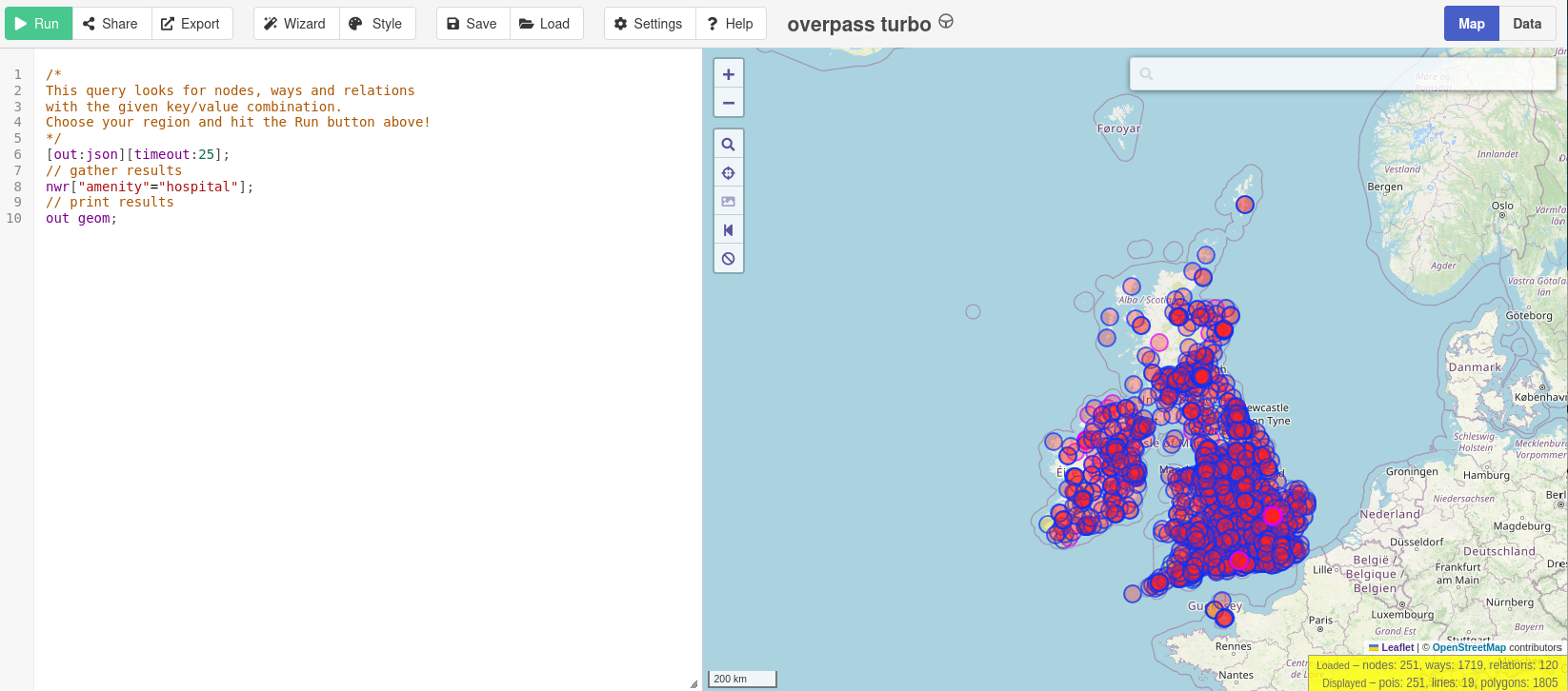
Note that this is an update of a previous diary entry. This version uses updated Overpass software from a fork.
Many people have noticed that publicly available Overpass servers have been suffering from overuse (a typical “tragedy of the commons”). OSM usage policies generally contain the line “OpenStreetMap (OSM) data is free for everyone to use. Our tile servers are not”. Unfortunately, there have been problems with overuse of the public Overpass servers, despite the usage policy. “Just blocking cloud providers” isn’t an option, because (see here - use the translate button below) lots of different sorts of IP addresses, including residential proxy addresses, are the problem.
Hi! For the last few years I’ve been building a service that exports OSM data into formats that live outside the GIS world: CorelDRAW (CDR), AutoCAD (DWG/DXF), SVG for illustrators, STL for 3D printing. It turns out the most grateful audience for OSM data isn’t cartographers at all: it’s signage designers who need a neighbourhood map as curves, civil engineers who need a DWG base plan, laser-engraving makers cutting city maps from DXF.
The main pain I had to solve was keeping LAYERS: roads, buildings and water should arrive in CorelDRAW as separate editable layers, not as one pile of curves. Every export is assembled from the same thematic groups OSM itself thinks in — roads, buildings, water, greenery, land use, POIs — and each group becomes a named layer of the target application: you can hide, recolour or delete it in one move instead of picking objects one by one. Street labels live on their own layer too — a signage designer usually wants them, a laser engraver almost never does.
The second pain is the boundary. A rectangle around a city inevitably drags in pieces of neighbouring areas, and cleaning them up by hand is painful. So exports can be clipped strictly to an administrative boundary: pick a city or district from the catalog (about 2.9 million admin areas across 179 countries) and every layer is trimmed to the outline, with cut polygons properly closed along the border.
The service: https://osm2cdr.com. All data © OpenStreetMap contributors, ODbL — attribution is embedded in every export. I’d love feedback from the community: what’s missing, and what feels un-OSM-ish?
Posted by no87xis on 27 July 2026 in Russian (Русский).
Привет! Я несколько лет делаю сервис, который выгружает данные OSM в форматы, живущие за пределами ГИС-мира: CorelDRAW (CDR), AutoCAD (DWG/DXF), SVG для иллюстраторов, STL для 3D-печати. Оказалось, самая благодарная аудитория данных OSM — вовсе не картографы: это дизайнеры вывесок, которым нужна карта района в кривых; проектировщики, которым нужна подложка в DWG; мастера лазерной гравировки, режущие карты городов по DXF.
Главная боль, которую пришлось решать, — сохранить СЛОИ: чтобы дороги, здания и вода приезжали в CorelDRAW отдельными редактируемыми слоями, а не одной свалкой кривых.
Устроено это так: каждый экспорт собирается из тех же тематических групп, которыми думает сам OSM, — дороги, здания, вода, растительность, землепользование, точки интереса. Внутри файла каждая группа становится отдельным именованным слоем целевой программы: слой можно скрыть, перекрасить или удалить одним движением, не выбирая объекты поштучно. Подписи улиц тоже живут отдельным слоем — дизайнеру вывески они обычно нужны, мастеру гравировки почти никогда.
Вторая боль — граница. Прямоугольник вокруг города неизбежно захватывает куски соседних районов, и вычищать их вручную мучительно. Поэтому экспорт умеет резаться строго по административной границе: выбираешь город или район из каталога (в нём около 2,9 млн административных единиц по 179 странам) — и все слои аккуратно обрезаются по контуру, а разрезанные полигоны корректно замыкаются на границе.
Сервис: https://osm2cdr.ru (мир: https://osm2cdr.com). Данные © участники OpenStreetMap, ODbL — атрибуция вшита в каждый экспорт. Буду рад обратной связи от сообщества: чего не хватает, что сделано не по-OSM-овски?

Moin.
Zum Einen, um sie für mich selbst zu speichern, zum Anderen, weil sie vielleicht noch nicht jedem bekannt sind, ein paar hilfreiche URIs:
Copernicus Browser
Copernicus Browser der ESA, bietet verschiedene Arten von Luftaufnahmen, neben dem sichtbaren Licht auch nahes und fernes Infrarot, Ultraviolett sowie spezielle Ansichten für z.B. die Landwortschaft, Luftverschmutzung, Überschwemmungen und Dürren, Geologie, Gewässer, Schnee und Gletscher oder urbanes und die Möglichkeit, durch verschiedene Aufnahmezeitpunkt zurück zu blättern.
World Imagery Wayback Machine
World Imagery Wayback Machine, bietet die Möglichkeit, Satellitenaufnahmen in Halbjahres- bis Jahresschritten rückwärts zu blättern, ähnlich der entsprechenden Funktion in Google Earth Pro.
Waldinfo NRW
Waldinfo.nrw, bietet speziell für NRW verschiedene, spezialisierte Kartenebenen, z.B. Landbedeckung (Cop4ALL), Baumartenklassifikation (Sentinel2), Vegetations- und Gebäudehöhen (nDOM), Forstliche Standortkarten, Vogel- und Naturschutzgebiete, Freizeitkataster und Wanderwege, forstliche Rettungspunkte, etc.
YoHours
YoHours, Visualisierung von Öffnungszeitenangaben in der OSM-Syntax. Nützlich, um Öffnungszeitenangaben vor der Eintragung in OSM zu testen, speziell, wenn sich diese durch Abweichungen in einem bestimmten Datumsfenster komplex gestalten.
ELWAS NRW
ELWAS-web NRW, verschiedene hydrologische Karten für NRW, z.B. Fließgewässer- und Seekennzahlen, Hochwassergefahrenkarten, Verzeichnis der Gewässerpegel und Grundwassermessstellen.
RIO - Oberbergischer Kreis
RIO OBK, Sonderkarten des Oberbergischen Kreises, z.B. Historische Karten und Luftbilder, Freizeitkarten, Klima- und Starkregenkarten.
INSPIRE WMS NRW
INSPIRE NW Gewässernetz, Fließgewässerkarte NRW auf der Basis von ATKIS-Basis-DLM (Grundgenauigkeit ATKIS +/-3m), monatlich aktualisiert.
Digitaler Zwilling
Posted by raphaelmirc on 27 July 2026 in Portuguese (Português).


NEW IBGE CNEFE 2022 TOOL FOR OPENSTREETMAP 🚀
The biggest update to the street name tool has arrived!
The system that verifies street names using CNEFE 2022 data has been completely redesigned based on community feedback! 🔄 WHAT’S CHANGED? TWO-WAY SYNC!
Before: We only corrected OSM based on CNEFE Now: Mutual alignment between both datasets!
✅ If OSM is wrong → Fix it on the map (JOSM/iD) ✅ If CNEFE is outdated → Fix it in the tool
“Paving the way for the future batch import of addresses!”
🎯 UNMISSABLE NEW FEATURES
🔐 OSM Login - Authentication required (goodbye bots!) 📦 Batch Editing - Resolve multiple streets at once (use with caution!) 🔗 Overpass-Turbo Integration - Quickly check sources in OSM 📋 Auto-Copy - Corrected name is ready to paste (Ctrl+V)! 🏷 Street vs. Place Switcher - For squares, villages, and special cases 📊 Collaboration History - See who has helped in your area
📈 Filters and Statistics - Track your progress! 👇 NEW DASHBOARD STEP-BY-STEP
Posted by raphaelmirc on 27 July 2026 in Portuguese (Português).

🗺 NOVA FERRAMENTA CNEFE 2022 IBGE PARA O OPENSTREETMAP 🚀
A maior atualização da ferramenta de logradouros chegou!
O sistema que verifica nomes de logradouros a partir dos dados do CNEFE 2022 foi completamente reformulado com base no feedback da comunidade! 🔄 O QUE MUDOU? MÃO DUPLA!
Antes: Apenas corrigíamos o OSM com base no CNEFE
Agora: Compatibilização mútua entre as duas bases!
✅ Se o OSM estiver errado → Corrige no mapa (JOSM/iD) ✅ Se o CNEFE estiver desatualizado → Corrige na ferramenta
“Preparando o terreno para a futura importação em lote dos endereços!”
🎯 NOVIDADES IMPERDÍVEIS
🔐 Login via OSM - Autenticação obrigatória (adeus bots!) 📦 Edição em Lote - Resolva vários logradouros de uma vez (use com cautela!) 🔗 Integração Overpass-Turbo - Verifique fontes no OSM rapidamente 📋 Cópia Automática - Nome corrigido já vai pro Ctrl+V! 🏷 Alternador Via x Lugar - Para praças, vilas e casos especiais 📊 Histórico de Colaboração - Veja quem já ajudou na sua área

RETEX : Questions existentielles sur ma rencontre avec panoramax
à suivre peut-être :
- entrée de journal (à venir) : Cartographier mon village
- entrée de journal (à venir) : Simple model 3D dans OSM
Je rappelle que ces entrées de journal ne sont ni des pages de WIKI, ni des conseils d’expert … . Ce sont juste des comptes-rendus d’expérience vécue ou des questionnements en cours mis ici pour servir à toute personne intéressée.
A l’origine : mon trekking urbain recyclage
(voir entrée de journal trekking urbain)
Lorsqu’il est apparu, en juin 2025, que j’allais passer devant les 1600 (que je pensais alors être 284) points d’apport de mon territoire, un contributeur m’a demandé de penser à tous les photographier et de verser les photos dans Panoramax, ce que j’ai accepté aussitôt.
Et me voilà parti avec mon smartphone à la main pour photographier chaque point d’apport (en fait une photo par conteneur et une photo pour le point d’apport constitué par le groupe de conteneurs). J’ai aussi à l’occasion pris des photos de quelques points notables (notamment des oeuvres de street art croisées au bord des chemins).
Comme je répondais à une demande sans avoir vraiment réfléchi à l’objectif, je ne me suis posé que peu de questions. J’ai rapidement compris qu’il y avait plusieurs instances de Panoramax avec un répertoire commun (références coordonnées entre les instances) et ai choisi l’instance OpenStreetMap simplement parceque je répondais à une demande OSM et visais principalement à mettre l’attribut panoramax=xxxxx sur mes conteneurs.
Rapidement une question : pourquoi ces photos?
Au bout de 800 photos versées (j’ai peut-être l’esprit un peu lent), je me suis interrogé sur l’intérêt de ces versements. J’y voyais deux objectifs possibles :
Posted by petrusko on 26 July 2026 in French (Français).

Ajout du parcours de “Mâcon Disc Golf - Parcours P.A.P.A.” à Mâcon (71)
Par ici : osm.org/node/14041516470
Posted by evyy on 25 July 2026 in German (Deutsch).
Last updated on 12 August 2026.
Seit ein paar Wochen versuche ich, möglichst viele offene OSM-Notes um Dingolfing abzuarbeiten. Es macht mir echt Spaß. In meiner Freizeit mache ich seit letztem eigentlich nur zwei Sachen: mappen und Survey machen.
Wo ich angefangen habe, war in Dingolfing fast alles rot (von den Notes her). Jetzt ist die Hälfte (oder vielleicht sogar mehr als das) grün.
Mein Ziel danach ist es, einige Osmose-Fehler zu beheben.
Posted by andygol on 25 July 2026 in Ukrainian (Українська).
Last updated on 28 July 2026.

Posted by Lyubomyr Malay on 24 July 2026 in Italian (Italiano).

Ho pubblicato su uMap una mappa interattiva che raccoglie i punti vendita delle principali catene di fast food presenti in Italia.
Al momento la mappa include:
- McDonald’s
- KFC
- Burger King
- Starbucks
- La Piadineria
- Roadhouse
- Alice Pizza
- Billy Tacos
- Old Wild West
- Five Guys
Tutti i dati sono stati raccolti direttamente dai siti ufficiali delle rispettive catene, con l’obiettivo di offrire una panoramica il più possibile completa e aggiornata della loro distribuzione sul territorio italiano.
Link alla mappa: https://umap.openstreetmap.fr/it/map/fast-food-chains-in-italy_1437687

I have been mapping on OpenStreetMap for a little over 11 months now. However, OpenStreetMap is not where my love for mapping started. 7 months beforehand, I started editing Google Maps. Every time I had a minute of free time, whether at my computer or on my phone while going to school, I would trace roads all around the world. I completely stopped doing anything else for fun other than fixing and creating roads.
However, this craze of mine ended on August 12th, 2025. I found out that more than 50% of my edits were being rejected by Google when I knew that all of them were OBJECTIVELY correct. I decided that I was done with Google Maps, but I needed something new to fill the hole that mapping had in my heart. That’s when I discovered OpenStreetMap 15 minutes later. I knew I had heard that name somewhere, so I decided to check it out.
Before I even completed the tutorial, I was hooked. While before I could only map walking paths, now I could map literally anything I want. Even the concept of mapping buildings was something I had to get adjusted to due to how small the number of things I could map on Google Maps was. I spent the rest of my day figuring out the mapping capabilities of the iD editor. The next day, I spent the entire day mapping and seeing what others had already mapped (spoiler alert: a lot).