Users' Diaries
Recent diary entries
A empresa IVIDES DATA® está com inscrições abertas para o seu ciclo de oficinas OpenStreetMap 2026

100% ON-LINE. Haverá 5 encontros de 15 em 15 dias - 08/05, 22/05, 05/06, 19/06 e 03/07 (sextas-feiras), 14 às 16h (UTC-3), contemplando diferentes temas:
* Mapeamento com OpenStreetMap
* Plugins para QGIS
* Formulários Web com KoboToolbox
* Mapas Web com uMap
Nível: para mapeadores de todos os níveis.
Perfil da professora:
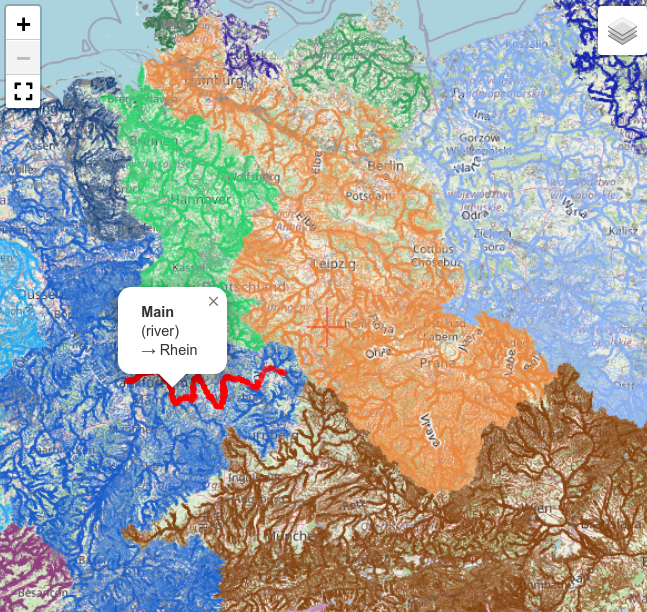
Die Karte der Flussgebiete Mitteleuropas erstelle ich nunmehr seit 13 Jahren aus OpenStreetMap Daten. In dieser Zeit gab es viele kleinere und größere Verbesserungen an der Software und an der Datenbasis. Geblieben ist das Grundprinzip: Der Algorithmus traversiert Wasser-ways und verbindet sie anhand gemeinsamer nodes zu Flussgebieten. Ein Renderer erstellt daraus eine Karte mit entsprechend dem Flussgebiet eingefärbten Wasserwegen (Details).
Das fortgeschrittene Tagging von Wasserweg-relations mit type=waterway erlaubte die Implementierung eines oft gewünschten Features: Ein Klick auf ein Element hebt den kompletten Wasserlauf von der Quelle bis zur Mündung hervor und zeigt Informationen zum Wasserweg an (siehe Bild).
Vielen Dank an alle, die durch Hinweise, Verbesserungsvorschläge und insbesondere die Pflege der Daten in OSM an diesem Projekt mitgearbeitet haben!
.JPG)
Kontribusi Wanita dalam Pemetaan Terbuka Level Street View
Peran wanita dalam dunia professional selama ini sering kali dianggap remeh oleh beberapa orang. Hal ini dikarenakan oleh adanya stigma bahwa wanita baiknya menjadi ibu rumah tangga mengurus anak dan permasalahan rumah tangga. Sebaliknya tugas pria adalah mencari nafkah dan pundi-pundi uang untuk keberlanjutan keluarga. Namun, di zaman modern ini pandangan seperti itu sudah dianggap kuno dan kurang relevan semenjak banyaknya teknologi yang telah dikembangkan untuk mempermudah wanita dalam beraktivitas seperti pria. Apalagi sudah banyak perkerjaan yang hanya bisa dikerjakan oleh wanita.
Dalam dunia survey lapangan, pandangan orang pada saat ini pun masih berkutat bahwa ini adalah pekerjaan yang berat dan lebih cocok dikerjakan oleh pria dibanding wanita. Tetapi Pandangan seperti itu pun sepertinya sudah banyak terbantahkan oleh beberapa wanita yang ikut banyak terjun ke dunia survey dan hasil kinerja mereka sangat baik tidak kalah dari kinerja yang dilakukan oleh pria.
Seperti yang kita ketahui, perempuan sering menjadi sasaran tindak kejahatan, baik dari orang di sekitar maupun dari orang yang tidak dikenal, terutama di ruang publik. Kondisi ini menyebabkan perempuan sering merasa tidak aman saat berada di jalan, menggunakan transportasi, maupun di tempat umum lainnya, baik pada siang maupun malam hari. Terjadinya aksi kejahatan itu, dipicu oleh kurangnya imformasi mengenai wilayah yang aman, dan wilayah yang tidak aman, minimnya penerangan jalan, serta kurangnya pengawasan di beberapa lokasi semakin meningkatkan risiko yang dihadapi perempuan. Oleh karena itu, diperlukan upaya yang terarah melalui peningkatan keamanan, penyediaan informasi yang akurat, serta pemanfaatan pemetaan digital menggunakan OpenStreetMap, kegiatan ini meliputi identifikasi area yang aman, dan area yang beresiko akan munculnya tindak kejahatan.
I often need to create a single GPX file from multiple related but different GPX files from Garmin and Wikiloc. My use case is finding route recommendations for running based on GPX files. I try to get a single GPX file so I do not have to juggle multiple files during the run. Original GPX files are also noisy, so the added advantage is having a precise path to navigate instead of dealing with GPX noise.
I start by putting all downloaded GPX files into a single directory and plotting them on the map. This step allows me to see them in relation to each other and spot any outliers early. I then simplify each GPX file to reduce the number of points and match them to OSM ways. I filter the points to make them evenly spaced. Finally, I use the OSRM trip service to create a single combined GPX file, or fall back to the minimal number of split files if they cannot be merged into a single file. I plot the resulting GPX files and simplify them to reduce the point count. Now I can sync them to Garmin and use them as a kind of basemap on a device that does not support basemaps.
Of course, this only works when I know the area in advance, can find enough existing route recommendations, and there is a reasonably complete OSM map. The current pipeline is error-prone and I find myself tweaking it to make it work with any specific set of GPX files. You can try it yourself and view the complete code on GitHub: https://github.com/evgeniyarbatov/gpx-courses
Why doesn’t MapsMe keep up with OSM? Doesn’t he care about updating the map to match OSM? All programs update the map and keep pace with OSM Why MapsMe?
Why doesn’t MapsMe keep up with OSM? Doesn’t he care about updating the map to match OSM? All programs update the map and keep pace with OSM ?Why MapsMe
Regional osm2pgsql updated minutely as an alternative to Overpass.
Short version:
Recently, I wrote a script that could help with OSM DB data replication using osm2pgsql by filtering .osc files with a specific .poly. It doesn’t limit to a specific continent or country, it can be used with any custom PBF (e.g. a specific city), so it doesn’t need to use .fr replication, it uses planet.osm.org directly (which also could be changed).
It’s inspired by the trim_osc.py script by Zverik, but rewritten from scratch with tests, because the script unfortunately didn’t work for me (maybe I did something wrong).
It’s not a very typical thing, so I’m not sure if it will be useful for anyone, but if someone would like try to self-host a regional OSM DB with replication, I recommend to at least checking it.
More details in the repo: osm-replication-osc-poly-filter
Longer version:
A few months ago, I was looking for an alternative for public Overpass instances (due to overloaded servers) for my projects.
I read SomeoneElse’s diary about self-hosting Overpass instance. But it seems over-complicated to me. I also read many times that there are random issues with reliability and it’s time-consuming to maintain it (not sure how true it is).
I decided that I want to switch to something else for my projects. Something more low-level with greater control of data and more likely self-hosted to avoid such problems. Instead of OverpassQL. I switched to SQL with a PostGIS DB. There are no a lot of choices here, so I chose osm2pgsql.
Osm2pgsql is quite advanced tool, which I really recommend at least reading about it – it may require some time to learn it, but it’s worth to seeing some features like --output=flex, which allows
to defining custom table schemas in Lua scripts with tags/geometry columns which works when importing and appending (replicating) data. It can be adjusted and optimized per project.
La vista de satélite para realizar la edición del mapa se encuentra desactualizada, (por lo menos en Colombia) lo cual hace un poco difícil actualizar algunos lugares que con el paso del tiempo ya han cambiado, como edificios, vías, parques, autopistas.
1,934 Unreviewed TIGER Road Segments Are Breaking Public Transit in Hamilton County
SORTA operates MetroNow, a microtransit service covering four zones in Hamilton County: Blue Ash/Montgomery, Springdale/Sharonville, Northgate/Mt. Healthy, and Forest Park/Pleasant Run. The service is powered by Via Transportation, whose routing engine consumes OpenStreetMap as its base map layer.
I am a daily MetroNow rider. A persistent routing failure at my address led me to inspect the OSM data that Via’s routing engine depends on. What I found on one street turned into a zone-wide audit. The results are significant enough that I want to share them with the local OSM community and ask for help.
The Street-Level Problem
A residential street in the Blue Ash zone carries two defects from the TIGER/Line 2008 Census import. Both carry tiger:reviewed=no. No human has verified this data since import.
-
False
oneway=yestag on a two-way residential dead-end street. The false one-way tag makes the routing engine calculate entry with no legal exit. The engine marks the street as unreachable. Drivers get redirected to a neighboring street. Riders get circuitous routes that bypass the correct address entirely. -
Disconnected node gap at a cross-street intersection. Two ways representing the same street do not share a node. The routing graph treats the street as two separate, disconnected segments.
For a transit-dependent rider with mobility limitations, a routing failure is not an inconvenience. It is a service denial.
The Zone-Wide Data
I ran the following Overpass query across the Blue Ash/Montgomery zone:
[out:json][timeout:90];
way["highway"]["tiger:reviewed"="no"]
  (39.16,-84.44,39.24,-84.33);
out tags;
Results:
Ces derniers jours, j’ai cherché à améliorer le mapping des quartiers de Genève dans OpenStreetMap.
Méthode OSM
OpenStreetMap représente les quartiers de Genève de deux manières principales :
- Par des ways et des relations dessinant les frontières (tags typiques : boundary=, admin_level=).
- Par des “nodes” (noeuds) indiquant leur emplacement approximatif (
place=*).
Ce mapping se concentre sur la deuxième approche: les “nodes” place=*.
Les “nodes” place=* se classent généralement par échelle croissante :
Couverture ailleurs
Les noms de quartier apparaissent ailleurs : subdivisions du territoire, voies et places, arrêts TPG, écoles primaires, locaux de vote, secteurs statistiques, etc. Ils sont souvent déjà présents indirectement dans OSM.
La Ville publie la page “Découvrir Genève et ses quartiers” avec les quartiers suivants:
- Eaux-Vives — Cité
- Servette — Petit-Saconnex
- Plainpalais — Jonction
- Acacias — Bâtie
- Champel
- Grottes — St-Gervais
- Pâquis — Sécheron
- St-Jean — Charmilles
Le SITG (et le registre foncier) donnent une subdivision de base en quatre “communes”:
Leurs frontières ne sont pas présentes dans OSM.
Cette subdivision est basée sur les anciennes communes que la ville a absorbées en 1931:
Le site Noms géographiques du canton de Genève décrit en général le quartier d’après lequel une voie est nommée.
La collection d’iconographie de la Bibliothèque de Genève (BGE) est également indexée par quartier.
Le site Genève-archi utilise les 4 communes et des secteurs dessinés sur fond de carte OSM.
Les wikis (articles et liste Wikipedia, Wikimedia, Wikidata) incluent certains et les combinent parfois. Même si les trois wikis sont reliés entre eux, ils ne se réfèrent pas forcément au même lieu.
Liste des quartiers
Voici un extrait:
After I got some experience with hosting OpenStreetMap tiles during the revival of Openptmap, I wanted to dig deeper into the topic in order to firstly migrate Openptmap to the new flex output so that it can receive incremental updates, and secondly to be able to host some additional overlays.
I found that the only widely used way to host tiles is overv/openstreetmap-tile-server. On the first look, it is really easy to use. It takes care of importing and updating the OSM database and of rendering and serving the tiles. On the second look however, there are some major challenges and problems with it:
I was looking for a house and decided to use OSM to help me find the optimal location. I had several fixed conditions: I knew my office location and I was looking for a condo close to a primary school. I used OSM to extract all schools and residential buildings. As there were many residential buildings, I used DBSCAN to find clusters and pick one representative building per cluster. To reduce the number of routes to compute, I used the OSRM table service to filter schools and houses within 5 km of each other. Then I ran the OSRM route service on triplets of (home, school, office). I saved the route polylines and locations into a CSV file, then created a KML file based on it and imported it into Google My Maps for visualizing the results. The resulting map is useful for getting a first impression of possible places to live. I am getting quite a few schools and houses to choose from, but I still find it valuable to have a view of the entire city that does not depend on what I happened to find first.
I’d like to announce the release of a new Docker container instance for Overpass.
I’ve been running Overpass locally for a couple of years and have dealt with some reliability issues by improving the shell scripts that drive database updates.
I’ve been sharing those shell scripts with people but I wanted a better way to distribute them. So, I put some effort into cleaning up the scripts (with some significant improvements – see below!) and packaged them in a container build.
Another Overpass Container?
Yes!
There’s already the excellent wiktorn/overpass-api which does a great job of setting up a local Overpass instance. If that looks good to you, you should definitely use it!
For my own use, I wanted something with all the improvements to stability and reliability that I had rolled into the shell scripts, but that would stay true to the original Overpass source code and that would expose all the same configuration options as if it were running on bare metal. I also wanted all the operational support that I already had locally, like configurable area generation intervals and periodic database backups.
Then, given the issues with the performance of public Overpass servers, and the efforts to limit large-scale usage, it seems that having more Overpass servers can only help the community.
What’s Different About This Container?
Better Database Updates
First, the database update process is much more robust. When things go wrong during Overpass database updates, the database files can be corrupted. And when that happens you have to start over with a fresh database, either from a backup or from a fresh download. That can mean many hours of downtime.
The shell scripts for database updates have been improved to shut down as gracefully under controlled circumstances and to handle uncontrolled shutdowns as safely as possible.
ES below
The Virtual Institute for Sustainable Development - IVIDES.org® and the company IVIDES DATA® is opening two vacancies to update and translate the content of its OpenStreetMap Course
The Virtual Institute for Sustainable Development – IVIDES.org® and the company IVIDES DATA® are offering a partnership opportunity to update and translate the content of their complete course into English (can be US-EN OR UK-EN) and Spanish (ES).
Conditions:
-
Both individuals and organisations are eligible to apply. However, organisations must be duly registered in their country in order to receive the funds;
-
Expected duration of the work: two months (June and July 2026);
-
Applicants must be citizens from an English- or Spanish-speaking country.
In return, the company offers:
-
Permanent promotion of the partner’s brand (and/or the name of the person responsible for the translation) on the course page and in all related materials, such as advertisements and others.
-
The full translation into each language will be rewarded with US$ 200. Complete PDF file: Raquel Dezidério Souto. (2025). Curso de capacitação em mapeamento com OpenStreetMap - Curso completo. Rio de Janeiro: IVIDES DATA, 2025. https://doi.org/10.5281/zenodo.17428748
If you’re interested in taking part, please send an email to:
ivides [at] ivides.org
with the details below. The deadline for registration is 8th May 2026. Let’s go!
-
Your CV (and/or a letter of intent);
-
Proof of identity (or national organisation registration document) AND
-
Your OSM username (full URL).
IVIDES DATA® is a small IT consultancy firm based in Rio de Janeiro (Brazil). We are fully registered in Brazil (CNPJ 56.127.866/0001-12) and can negotiate/operate worldwide.

Всем привет. Поскольку я, в основном, занимаюсь правкой и добавлением объектов, которые посетил лично, то с некоторого времени начал задумываться о том, как зафиксировать максимальное количество сведений об объекте непосредственно на месте. Почему?
-
Объекты в OSM, как правило, содержат мало тегов с информацией, поскольку они зачастую нарисованы с использованием спутниковых карт и картографирующий человек может даже никогда не видел их вживую.
-
При достаточно долгих прогулках/походах/путешествиях очень трудно воспроизвести по памяти характеристики леса, дороги и пр., из-за чего много важной информации впоследствии теряется.
С недавних пор, чтобы улучшить качество информации о добавляемых объектах, я стал действовать следующим образом.
На смартфоне я создал таблицы для быстрого заполнения (лично я использую Numbers, но можно всё что угодно), содержащие приблизительно следующую структуру:
| Точка | Тег 1 | Тег 2 | Тег 3 |
|---|---|---|---|
| 1 | <свойство> | <свойство> | <свойство> |
| 2 | <свойство> | <свойство> | <свойство> |
| 3 | <свойство> | <свойство> | <свойство> |
Возможные свойства тегов (*<свойство>*) задаются в виде выпадающего списка, чтобы их можно было быстро выбрать на телефоне. Для каждого типа объекта делается отдельный лист в электронной таблице, например, "лес", "дороги", "болота" и т.д.
Когда мы путешествуем, создаём файл по описанному шаблону с каким-нибудь именем, например: OSM_20260427. Затем в нужном месте ставим в приложении карт метку с номером там, где мы находимся, например, 3 на какой-нибудь дороге, а затем в электронной таблице на нужном листе (в данном случае дороги) ставим номер метки и заполняем быстро свойства объекта. Например, вот пример трёх точек для тех же дорог:

Here’s what’s changed in the UrbanEye3D plugin over the past week.
We’ve got translations for several more languages: Indonesian, French, and Cornish.

Translations into Spanish and Portuguese as well as into Volapük and Esperanto would be greatly appreciated. Just in case you would like to do that, the pot file can be found here.
Hello, I wish you many happy days. Please note, all the applications you use for OSM have updated their map data, for example, Organic Maps, OSM, and other projects that use OSM, except for MapsMe.
My maps were modified a long time ago, and the data for my area, New Cairo, Egypt, has not been updated. I have contacted them and sent them messages many times, but they have not updated the map data to match OSM. MapsMe is noticeably delaying data updates.
Please advise on this matter.
Thank you.

鹿児島市の建物数集計(2026年4月24日時点)
- noteなどで、建物の集計を行っている記事を見て、自分もやってみたくなった。
市内建物の総数を推定するのは、自分は数字が得意ではないので、国土地理院タイルの建造物を利用させてもらった。 - せっかく集計したので、日記として公開してみる。
検証用データ
- 基準建物数
- 国土地理院ベクトルタイル(PBF)
- 2026年1月1日時点
- 建築物を抽出し、分類別にディゾルブ処理
- 異形状、微小ポリゴンを除くため、ポリゴン面積 15㎡以上 を抽出
(車1台分の車庫程度) - 境界をまたがる建物は二重計上されないよう、ポリゴン内の代表点に変換
- 国土地理院ベクトルタイル(PBF)
- 比較対象数(OSM)
- Geofabrik(PBF)
- 2026年4月24日時点
- building=* areaのみを抽出
- 同様にポリゴン内の代表点に変換
- Geofabrik(PBF)
- 抽出エリア(行政界)
- e-statより国勢調査(2020年小地域(町丁・字等))
- 町丁・字でディゾルブ処理で一意化
- e-statより国勢調査(2020年小地域(町丁・字等))
集計結果
- 集計は町・字単位で行ったけど、300以上に分かれるので、地域単位にまとめて掲載
| 地域 | GSI | OSM | 網羅率 | 残り |
|---|---|---|---|---|
| 全域 | 262,204 | 135,984 | 51.9% | 126,220 |
| 中央地域 | 87,835 | 63,323 | 72.1% | 24,512 |
| 谷山地域 | 69,559 | 34,740 | 49.9% | 34,819 |
| 伊敷地域 | 27,458 | 7,790 | 28.4% | 19,668 |
| 吉野地域 | 27,676 | 12,638 | 45.7% | 15,038 |
| 桜島地域 | 6,829 | 4,960 | 72.6% | 1,869 |
| 吉田地域 | 11,154 | 5,413 | 48.5% | 5,741 |
| 喜入地域 | 10,981 | 2,484 | 22.6% | 8,497 |
| 松元地域 | 11,446 | 2,958 | 25.8% | 8,488 |
| 郡山地域 | 9,266 | 1,678 | 18.1% | 7,588 |
感想
- 鹿児島市の建物マッピングは全体で51.9%。先輩方に感謝。
- 中央地区が7割超えている一方、周辺地域は5割未満、郊外はさらに低い。
- マップからでも新興住宅地で建物が起こってないところが多いのを確認できる。
- 参考値なので100%または上回る必要はない。9割いけば、ほぼ網羅として判断してよさそう。
- 毎日100件追加したとしても、全域カバーには3年以上。先はまだ長い…
- 焦らず、空いた地域を少しずつ埋めていきたい。
おまけ(鹿児島市内の消防水利)
鹿児島市消防局令和7年版消防年報より
- 消火栓: 6,741基
- 防火水槽: 924基
- 計: 7,665基
- 防火水槽は地下式消火栓のようなマンホール型もあるので、総数で比較する。
OSM
- emergency=fire_hydrant: 1,407基
- emergency=water_tank: 15基
- 計: 1,422基