
20.11.2018-26.11.2018
Picha
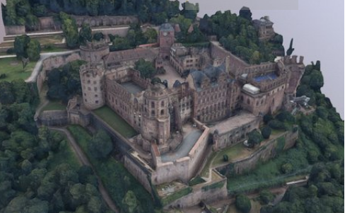
| 3D model of the Heidelberg Castle, one of the most famous ruins in Germany [^1^](#wn436_18879) | © Landesamt für Denkmalpflege im Regierungspräsidium Stuttgart 2018 |
Kutengeneza Ramani
-
John Whelan hisa maoni yake kuhusu mrad kuunda Canada 2020 na jinsi ya kuendelea na majengo ya ramani. Kuondolewa kwa takwimu za serikali na matarajio ambayo Microsoft itaachia nyaraka za ujenzi kama walivyofanya kwa Marekani inamfanya kuhitimisha kuwa kuongeza kwa metadata inaweza kuwa bora kuliko kuwa na wapiga mapaji wasio na ujuzi kufuatilia majengo kwa kutumia iD.
-
Pendekezo
 (moja kwa moja tafsiri) imeonekana kutoka majadiliano katika jukwaa la Kijerumani kuhusu sheria za matumizi ya mahusiano na
 aina = multipolygon. Nia ya pendekezo ni, tu alisema, kuepuka mahusiano ya multipolygon ikiwa jiometri inaweza kupangiliwa kwa njia moja inayowakilisha eneo, yaani hakuna maeneo ya ndani na chini ya nodes 2000 kwa njia ya nje ya eneo hilo. Mada hii sasa inajadiliwa kwenye jukwaa German forum (automatic translation ) na German mailing list (automatic translation) na inalenga kuwa mwongozo wa mazoezi bora kwa Ujerumani awali. -
Kupigia kura kwenye pendekezo la lebo
boundary=aboriginal_landskwa wilaya rasmi ya makundi ya asili imeanza miaka minane baada ya kuandaa yake na imefunguliwa hadi tarehe 8 Desemba 2018. Alan McConchie aliunda Suala la GitHub kwa mtindo wa ramani ya OSM Carto pia na inapendekeza utoaji wa rangi ya kahawia -
Warin alihisi kwamba Wiki kwa antenna inahitajika upya ili kuruhusu ufafanuzi bora wa aina ya antenna. Kama yeye ni kuchanganyikiwa na maadili ya muhimu
antenna: ainakatika sehemu ya Kijerumani ya wiki na pia haipendi ufunguo huo, anaangalia njia mbadala.
Jamii
-
InfosReseaux aliandika chapisho kwenye jarida lake la OSM kuhusu ramani ya miundombinu kama mitandao ya nguvu. Makala inaelezea jinsi ujuzi wa miundombinu unabadilika kutoka kwa wamiliki kufungua ujuzi na OSM na jinsi ramani ya miundombinu inafanya OSM kuwa bora zaidi.
-
Kama hivi karibuni umetumia Pascal Neis’ How You Contribute tovuti, huenda umeona sehemu mpya inayoitwa Kutumiwa kwa presets - Juu 3. Katika chapisho la blogu Pascal anaelezea kuwa ni lengo la kiashiria kipya cha ubora.
Taasisi ya OpenStreetMap
-
Hivi karibuni Uamuzi wa DWG juu ya uongo wa Crimea umesababisha majadiliano mengi:
- muhtasari wa lugha ya Kirusi katika OSM-Blog ya Zverik
 (automatic translation)
 - Majadiliano katika Kiukreni OSM-Forum (sehemu ya Kiingereza, sehemu ya Kiukreni) (automatic translation)
- Mazungumzo juu ya majadiliano orodha ya barua pepe ilianza na baada ya kukataa uamuzi.
- Machapisho kadhaa ya diary ya OSM na wapiga mapapa wa Kiukreni wanaopinga uamuzi ikiwa ni pamoja na hii na Kilkenni (kwa maoni mengi, ikiwa ni pamoja na baadhi ya kupinga mashambulizi ya ad-hominem ambayo ina).
- Juu ya reddit
- Watu wengi wamependekeza jinsi ya kupigia maeneo yaliyotofautiana na yaliyodai kwenye Talk na Tagging (1, 2) orodha za barua. (pendekezo la johnparis, mapendekezo ya Rory). Pia ilijadiliwa kama ni busara kuhifadhiwa madai hayo katika OSM wakati wote.
-
Mtu ametumamalalamiko rasmi kwa bodi ya wakurugenzi wa OSMF.
-
Bodi ya OSMF ilipasha habari wanachama ambao wamekataa ombi la kukataa maombi ya uanachama kuhusiana na “molekuli kuandikisha akaunti mpya 100 mnamo Novemba 15, 2018 kutoka India, wengi kutoka kwa anwani moja ya IP kutoka kampuni inayojulikana kwa OpenStreetMap. Wanachama wapya hawastahiki kupiga kura mwaka huu. Hata hivyo, uamuzi ulifuatiwa na mjadala wa muda mrefu juu ya orodha ya barua pepe.
-
Joost Schouppe, mgombea wa uchaguzi wa bodi ya OSMF ya mwaka huu, alichambua uanachama wa OSMF wa nchi kwa jumla na kuhusiana na idadi ya wafadhili.
- Dakika ya Mikutano ya Kundi la Kazi ya Data ya 10 Julai, 13 Septemba na 15 Novemba zimechapishwa katika eneo la “dakika ya kazi”.
OSM ya Kibinadamu
-
Erasmus + OpenStreetMap ya Uhuru wa Ulaya ya Vijana (euYoutH_OSM) Wanafunzi alitangaza kwenye tweet ambayo mnamo Novemba 23, walimu wengine wa ESJEA walianza mafunzo yao katika OpenStreetMap katika kikao kilichoongozwa na walimu Nuno Azevedo na Elizabete Oliveira. Walimu walifanya kazi na JOSM kuweka Kitanda cha Terceira zaidi na zaidi kwenye ramani. euYoutH_OSM alitangaza mnamo Novemba 26, kozi ya Mafunzo ya Michezo ilikuwa na nafasi ya kupokea mafunzo katika JOSM. Walihitimu wa kozi hii wamejifunza jinsi ya kuunda majengo, mali na kuchapa miundo ambayo bado inaweza kupangwa.
-
HOT na Kathmandu Living Labs itashirikiana na ramani ya Kathmandu, mji mkuu wa Nepali. KLL itaweka majengo mbali mbali kabla ya habari itakusanyika chini ili kukamilisha tathmini. Matokeo yatatumika kuthibitisha seti za data kwa Nepal ambazo zinaonyesha kutolewa kwa kanda kwa hatari za asili.
-
Wanafunzi watatu wa sayansi ya data wanauliza kwa “mikoa kuthibitishwa” kwa ajili ya mradi wa kujifunza mashine. Mpango ni kupakua dataset ili kufundisha na kupima mifano ya ramani ya automatiska kwa kutumia picha za satelaiti.
Elimu
- Sehemu ya Machafuko ya Dhamana ya Data Analyst course inatumia Openstreetmap kama mradi. Wanafunzi huletwa kwa OSM na mfano wa data na wanapaswa kuuza nje, kuchuja na kuchambua eneo kubwa kutoka kwa OSM.
Ramani
-
Wakala wa Ingress Hinata Kino alichapishwa
 ramani halisi ya maeneo ya anime ya ingress. alipiga ramani mahali ambapo tukio lililotokea kwa anime kutumia ramani kulingana na OSM.
 -
Mtumiaji wa Wikipedia Triglav aliandika
kuhusu njia ya kuingiza OSM kwenye kurasa za wikipedia. Unaweza kuunganisha uhusiano wa OSM na Wikidata na kuionyesha na Wikipedia.
Programu
-
Cadcorp, mtoa wa Uingereza wa huduma za GIS, kwa mamlaka za mitaa hasa,wamesasishwa programu yao na sasa inajumuisha safu ya OSM.
-
Toleo la alpha la Atlasr, kivinjari cha ramani ya wazi, imetolewa . Atlasr ina moduli kama database ya data ya ramani, mchezaji wa ramani, seva ya tile, geocoder na routing. Inalenga kutoa laini, la haraka, la kuaminika, lazuri, na mbadala ya chanzo cha GoogleMaps, kulingana na data wazi,. Programu inapatikana kwenye GitHub.
Programming
- Matthias (jina la mtumiaji wa OSM!I!) Alijaribu kutambua maneno na kuunganisha kwa JOSM - speech2josm. Mfano umeandikwa katika Python. Matthias anataka kupata mtu ambaye anaweza kuunda hii kama Plugin mpya ya JOSM. Anaandika zaidi katika chapisho lake la blogu. (automatic translation)
Matoleo
-
Toleo 4.17.0 ya mtindo wa OSM ya Carto imetolewa. Kama Daniel Koć anaandika katika blogu yake, mabadiliko yanajumuisha utoaji wa maeneo ya asili, kusafisha utoaji wa zoom kati, kama vile mpya utoaji na icons mpya kwa vipengele kadhaa.
-
Kundi la Utafiti wa GIScience wa Chuo Kikuu cha Heidelberg imechapisha toleo la 3.2 la QGIS OSM Tools. Sasa inajumuisha upatikanaji wa kazi za uendeshaji wa openrouteservice.org.
-
QGIS 3.4 ‘Madeira’ hivi karibuni imekuwa iliyotolewa. Toleo hili ni toleo la kwanza la muda mrefu kwa toleo la 3. Toleo jipya linajumuisha tani ya vipengele vipya kwa changelog mrefu sana.
Je, wajua
- … ramani ya kina sana ya Bexhill-on-Sea nchini England, iliundwa kwa OpenStreetMap? Na sasa kwa suala la juu. Inapendekezwa sana kwa mashirika yote ya kazi katika utalii.
OSM katika vyombyo bya habari
-
Nyaraka ya Deccan ripoti kuhusu tukio, lililohudhuria katika Taasisi ya Hindi ya Usimamizi-Bangalore, ambapo wapanda ramani zaidi ya 300 kutoka nchi 12 walijadili mada kuhusiana na ramani ya maafa kama umuhimu wa ramani ya maafa, lugha za jukumu zinacheza katika kuweka alama, maeneo ya jamii na mengine mengi.
-
Tovuti - Bora India_ inapendekeza wasomaji wake huchukua hobby mpya: OSM. Kifungu hiki kinashughulikia misingi ya OSM, nini OSM inaweza kufanya kwa jamii ya kiraia na inaelezea Jimbo la hivi karibuni la Ramani nchini India.
Vingine vya kijeographia
-
Taasisi ya Open Data (ODI) inaita serikali kuvunja utawala wa vituo vya kibiashara vya mtandao wa data ya Uingereza ya geospatial kwa kusonga mfano wa biashara wa miili ya umma zaidi kuelekea data wazi na kufikiria juu ya mamlaka upatikanaji wa data ya geospatial ya makampuni binafsi. Mjadala mkali, wa umma unapaswa kujadili jukumu la mashirika ya umma na ya kibinafsi katika mazingira ya data ya geospatial.
-
Maloto ya Manispaa tweets picha ya ramani ya zamani ya mfumo wa maji taka kuu ya London.
-
Nchi ya Ujerumani Baden-Wurtemberg imetoa mifano mingi ya 3D ya majumba ya kihistoria, majumba na monasteries chini ya leseni ya wamiliki. Sketchfab iliyohifadhiwa inashikilia saraka kwa, kwa sasa, isiyo ya kupakuliwa, mifano ya 3D. Hasara nyingine pekee ni kwamba Castle ya Neuschwanstein iko Bavaria.
-
Paul Ramsey blogged kuhusu majibu ya mwakilishi wa mauzo ya ESRI wakati Paulo alizungumza na kikundi cha watumiaji wa GIS kuhusu mitaa kuhusu hatari za kuwa amefungwa mtayarishaji mmoja wa programu. (kupitia @anonymaps)
Matukio yajayo
-
Where What When Country Alice PoliMappers Adventures 2018: One mapping quest each day 2018-12-01-2018-12-31 
Toronto Mappy Hour 2018-12-03 
Niamey OSM and GIS training camp at CNF 2018-12-03-2018-12-07 
London London Missing Maps Mapathon 2018-12-04 
Viersen OSM Stammtisch Viersen 2018-12-04 
Praha - Brno - Ostrava Kvartální pivo 2018-12-05 
Stuttgart Stuttgarter Stammtisch 2018-12-05 Toulouse Rencontre mensuelle 2018-12-05 
Bochum Mappertreffen 2018-12-06 Dresden Stammtisch Dresden 2018-12-06 Nantes Réunion mensuelle 2018-12-06 Tångstad Foundation board elections voting opens 2018-12-08 - Rennes Réunion mensuelle 2018-12-10 Lyon Rencontre mensuelle pour tous 2018-12-11 Zurich Jubilee Stammtisch Zurich with Fondue 2018-12-11 
Salzburg Maptime Salzburg 2018-12-12 
Helsinki Missing Maps Mapathon at Finnish Red Cross HQ - Dec 2018 2018-12-13 
Munich Münchner Stammtisch 2018-12-13 Berlin 126. Berlin-Brandenburg Stammtisch 2018-12-14 online via IRC Foundation Annual General Meeting 2018-12-15 Cologne Bonn Airport Bonner Stammtisch 2018-12-18 Lüneburg Lüneburger Mappertreffen 2018-12-18 Nottingham Pub Meetup 2018-12-18 Reutti Stammtisch Ulmer Alb 2018-12-18 Rennes Recensement des panneaux publicitaires 2018-12-23 Heidelberg State of the Map 2019 (international conference) 2019-09-21-2019-09-23

 (
(


 Pristina, mji mkuu wa Kosovo, imetengeneza