Users' Diaries

Recent diary entries

··· I didn’t start contributing to OSM because of any grand philosophy or ideology. I simply began editing because I needed to. But as I became more involved, I learned more about what I believed OSM stood for—openness, decentralization, freedom to collaborate, and a community built around shared stewardship rather than commercial ownership. At least, that was how I came to understand OSM.

That understanding was what motivated me to continue contributing. I chose to spend my time improving OSM instead of Google Maps or the dominant commercial map used in my country. I even spent time studying OSM’s principles and community practices because I wanted to contribute in a way that respected those values.

If utility had been my only motivation, I probably wouldn’t have contributed to OSM at all. In the region where I live, almost nobody actually uses OSM. From a purely practical perspective, my efforts have very little visible impact. Yet I kept contributing because I believed OSM represented something fundamentally different from commercial mapping platforms. That belief—not efficiency or popularity—was what made my contributions meaningful.

For that reason, I don’t believe corporate participation is inherently a problem. OSM is open to everyone, and companies should absolutely be free to use the data and contribute to improving it.

My concern is not that companies participate. My concern is whether, over time, the priorities of the project could gradually shift toward the interests of organizations that naturally have business objectives and far greater resources than individual volunteers. Simply saying that “companies are part of the community” doesn’t fully address that concern. To me, the more important question is not whether companies belong here, but how the community ensures that the values and priorities shaped by volunteers remain just as influential as corporate interests.

Perhaps this is the source of my confusion.

See full entry

Mapping

Over the past year, our OpenStreetMap Pakistan community has been actively working to map high-risk flood zones across the country—both areas historically affected by extreme flooding and regions facing critical vulnerability during upcoming monsoon seasons.

Shifting from Reactive Response to Proactive Preparedness

During last year’s monsoon floods, our mapping response began after the disaster had already struck. While those post-disaster edits were vital for ongoing emergency response, we recognised the need to get ahead of the curve.

This year, we shifted our strategy completely: we initiated pre-disaster mapping well before the monsoon season arrived.

By leveraging flood projections and high-risk zone data from the National Disaster Management Authority (NDMA) and prominent emergency monitoring sources, we identified priority regions across Pakistan. We began our efforts by focusing heavily on areas categorised as the highest risk of severe flooding, ensuring that digital infrastructure is in place before rising waters cut off communities.

Community Coordination & HOT Tasking Manager

Together with two fellow community members, I took charge of creating, organizing, and managing dedicated projects on the Humanitarian OpenStreetMap Team (HOT) Tasking Manager.

To drive contributions and sustain momentum, we have been organising community mapping parties and mapathons. Local mappers and volunteers across Pakistan came together to trace the following:

*Missing road networks and bridge connections

*Remote village footprints and building clusters

*Key natural landmarks and waterways

These precise layers are already empowering ground rescue teams, military logistics, and international aid agencies to plan evacuation routes, calculate population exposure, and navigate flood-affected corridors.

Global Recognition

Our community’s proactive mapping drive was recently highlighted in a feature article by the UK newspaper Oxford Herald:

See full entry

Posted by rphyrin on 5 August 2026 in English.

This afternoon, I noticed that several of my colleagues were visiting a recently opened school in the far south.

They took several photos, which is quite a rarity on the internet, since not many people actually go there and upload pictures of the newly built buildings.

I wanted to upload those photos, hoping they might be useful for anyone trying to find information about the place.

Then I remembered that OpenStreetMap has this image=* tag.

I could associate an image with the place by adding an image URL there. So I opened Vespucci on my Android phone and added the image URL to the object.


Now I’m back at my PC, and I wanted to make a simple app (or maybe just a script) to browse every image=* tag that exists in OpenStreetMap.

At first, I thought of doing it the usual way : build a Leaflet web map, query the Overpass API, then display the images in popups.

But then I remembered that the Overpass API has recently been under heavy load.

From what I’ve heard, it’s because of a barrage of AI scrapers… or maybe just a flood of quick-and-dirty, vibe-coded OSM apps being produced en masse.

Whatever the exact reason, it has noticeably affected the service.

Knowing that, I was discouraged from making the situation any worse. So I scrapped that idea.


Then I remembered something else:

Overpass Ultra.

I don’t know exactly how it works internally, but I assume it uses a different Overpass API endpoint than the ones I would normally query directly.

If that’s the case, perhaps using Ultra wouldn’t add to the current strain on the public Overpass servers.

I also realized that Overpass Ultra’s advanced styling syntax lets me solve the whole problem directly within the query itself, without having to build my own Leaflet-based web app.

So here it is: a quickly put-together Ultra query that displays every OpenStreetMap object containing an image=* tag and shows the referenced image in a simple popup.

See full entry

Life in a multi-million population City can be tough on Introverted minds. For me, mapping in OpenStreetMap is first and foremost an activity to improve publicly accessible geodata around my local and known places, though it has also recently become a way for me to virtually travel to far away places. Exploring remote corners of the earth that are not quite as bustling with activity, where not every square-meter has already been meticulously mapped to the nth degree. Theres even a subreddit for this kind of exploration: /r/GoogleEarthFinds !

Zooming in on a random patch of rainforest, a tiny island in the pacific or one of the thousands of meandering arms off the Amazonas shows a mostly untouched view of nature. Panning around looking for interesting landmarks, it only takes a few minutes to stumble upon a secluded village whose roads are not even connected to the world-wide network, or a lonely farm in the middle of nowhere. These are the places that fascinate me the most. I get lost in imagining what life is like there, who lives there, what untold stories do these places hold? While daydreaming of this, i map the buildings I see, paths and roads, things that can safely be confirmed from aerial imagery. Switching to different imagery providers can show how these places evolved, has the village grown or shrunk? Have Roads been extended or left to be reclaimed by mother nature? A handy website for viewing satellite imagery with different timestamps is https://livingatlas.arcgis.com/wayback

Usually I just zoom into random places and see where it takes me. With the power of Overpass Turbo, one can find places in a slightly organized fashion. Below is a prompt which shows islands that have residential areas on them, within the current view of the map:

[out:json][timeout:25];
(
nwr["place"="island"]({{bbox}});
  );

nwr["landuse"="residential"]({{bbox}});

// print results
out geom;

Or simply highlighting villages in the current map view:

See full entry

Location: Novo Ceú, Autazes, Amazonas, North Region, Brazil
Posted by Kay Covey on 2 August 2026 in English. Last updated on 9 August 2026.

August 2–8

August 2

  • Fixed Reynoldsburg borders; borders now up-to-date as of most recent annexation on May 24, 2026.
  • Updated Reynoldsburg population; increased to 43,350 according to U.S. Census Bureau.
  • Added intermittent stream called Little Jordan Run.
  • Modified Jackson Avenue; changed “one way” value to “no” and added note that signage by the Street Department is incorrect. Correct name is Jackson Avenue not Jackson Street.
  • Modifed Burkey Avenue; changed “one way” value to “no” and added note that signage by the Street Department is incorrect. Correct name is Burkey Avenue, not Burkey Drive.
  • Modified Burkey Court; switches from Burkey Avenue to Burkey Court at the intersection with Southwood Avenue, not in the middle of the road.
  • Fixed name of Taylor Park Drive (originally shown as just “Taylor Park”).
  • Fixed differentiation between Taylor Road and Taylor Road Southwest.
  • Added info to Raider Stadium (Reynoldsburg High School football stadium).
  • Removed Smokey Bones brand from building at 2200 Baltimore-Reynoldsburg Road (closed permanently after bankruptcy).
  • Added info to Reynoldsburg High School’s Livingston Campus.

August 3

  • Fixed name of Taylor Road.
  • Added 5 ponds near Lakeland Hills neighborhood.

August 5

  • Added name of TS Tech Drive as indicated by street signs in the area.
  • Added name to the remaining portion of Wilma Drive.

August 9–15

August 9

  • Removed nonexistent Truro Township enclave inside Reynoldsburg around Blacklick Creek.

Gerade eben mappe ich den Bayern-Park detaillierter. Durch meine frühere Jahreskarte konnte ich den Park oft besuchen und kenne daher viele Bereiche aus eigener Erfahrung. Jetzt nutze ich dieses Wissen, um Details des Parks in OpenStreetMap zu verbessern.

Als Ziele habe ich folgende:

  • Alle POIs überprüfen und ggf. eintragen/aktualisieren
  • Alle (oder zumindest den größten Teil von allen) Wege überprüfen und ggf. hinzufügen/aktualisieren
  • Generell mehr Details hinzufügen

I am currently focusing my mapping work on the Taiping Heritage Zone. Most of the shoplot footprints and major buildings have been completed, and I am now working on detailed micromapping for schools, museums, and government buildings.

Please feel free to contribute by adding any missing information, such as shop or stall names, building levels, address numbers, or other relevant details that I may have missed.

Let’s work together to make Taiping one of the most complete and detailed small-town maps in Malaysia on OpenStreetMap.

Posted by lhirlimann on 1 August 2026 in English.

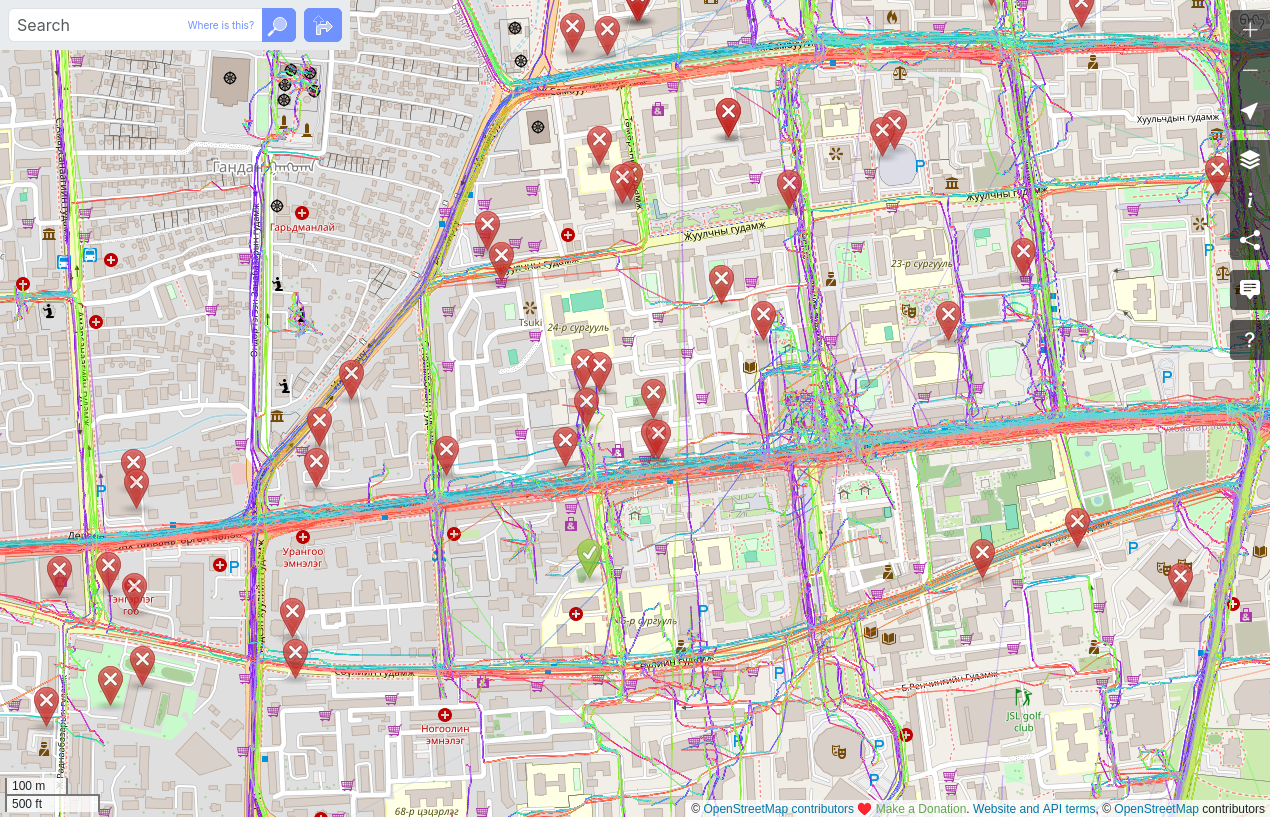
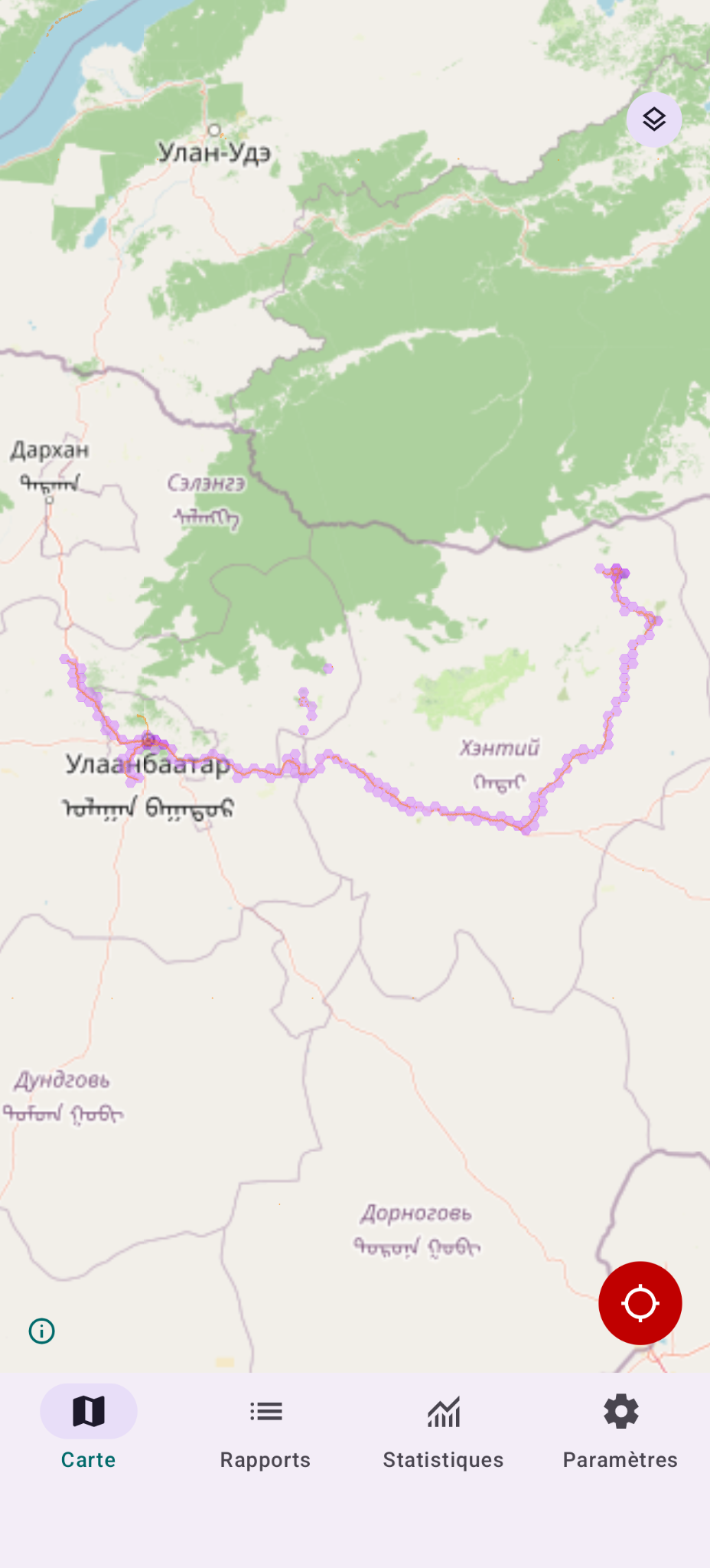
As explained in this french diary entry I left a bunch of notes, took a bunch of traces while visiting Mongolia in July. The main reason, was that I was playing with StreetComplete and firing Vespucci would have annoyed my wife adding notes was easier. So I left notes, for later. Today I decided to start editing based on my memory and some of the notes. While editing, I saw a very high number of these in the center of UB. screenshot of the browser Firefox showing Openstreetmap.org in edit mode with notes visible. You see a lot of these notes in a very small area

Many are old, and the imagery is old. Is there a process to clean up notes? Are there people willing to spend time taking these notes and making the edits that for some are probably needed?

Location: Gandan, Bayangol, Ulaanbaatar, 16040, Mongolia

この diary は アカウントロックされた経緯の説明 の関連記事です。

DWGが仕事をしていないようなので催促しました

Glassmanによる不当なアカウントロックと ‘int_name’の大量削除問題 を3月に「通報」したのですが、なんの進捗もないようなので催促のメッセージを送りました。 osm.org/user_blocks/19857

原文はこちらです(英語)
Re: 2026年08月 1日 04:27

日本のコミュニティ向けに日本語の翻訳を示します。


[Ticket#2026013110000088]https://www.openstreetmap.org/messages/1338706

DWG(Data Working Group)への声明(日本語訳)

DWGの皆様へ

まず、返信が遅れたことをお伝えいたします。
この遅延は意図的なものであり、int_name に関するコミュニティフォーラムでの議論が一定の段階に達し、適切な説明が可能になるまで待つ必要があったためです。
https://community.openstreetmap.org/t/key-int-name-must-be-deprecated/142316/49

この期間中、DWGからのコミュニケーションにおいて重大な誤解が存在することが明らかになりました。
DWGは、私 hayashi を別のマッパー「無限の刃」と繰り返し混同しています。
この誤認により、本来別の人物に向けられるべき指摘や警告が私に対して送られ、DWGのメッセージには一貫性がなく、対応不能な状態が続いていました。

私は hayashi です。
私は 無限の刃 ではありません。

int_name の削除を提案し、実際に削除を行ったのは 「無限の刃」氏であり、私ではありません。


1. 「あなたの主張」という誤った認識について

DWGは以前、次のように述べています。

> I'm not sure you have people convinced with your argument. > あなたの主張で人々を納得させられたかどうかは、定かではありません。

しかし、この評価は事実に反しています。

  • int_name の廃止を主張したのは 「無限の刃」氏 です。
  • int_name を大量削除したのも 「無限の刃」氏 です。
  • 日本コミュニティからの警告を無視したのも 「無限の刃」氏 です。
  • この行為を通報したのは 私 hayashi です。

私は int_name を削除していません。
私は int_name の廃止を主張していません。
私はただ、int_name を廃止する理由を質問しただけであり、その質問には一度も回答がありません。
参照: https://community.openstreetmap.org/t/key-int-name-must-be-deprecated/142316/38

さらにコミュニティフォーラムでは:

  • 「無限の刃」氏の提案を支持する投稿は 一つもありません
  • 私の意見を「一方的」と批判する投稿も 一つもありません
  • 多くのマッパーが「無限の刃」氏の一方的な行動に懸念を示しています

DWGが「私の主張がコミュニティを説得できていない」と述べたのは、人物の取り違えによる誤認です。


2. 私への「コミュニティ参加の推奨」を繰り返すのはやめてください

DWGは繰り返し、私に「ローカルコミュニティに参加するように」と促しています。
これは不適切であり、直ちにやめるべきです。

私は長年、日本のOSMコミュニティに積極的に参加してきました:
osm.org/user/hayashi/diary/408467

日本コミュニティではすでに:

  • name:en の用法が議論され
  • Wikiに合意内容がまとめられ
  • int_name の扱いについても共通理解が形成されています

DWGが私に「コミュニティのフィードバックを求めよ」と指示するのは、以下の事実を無視しています:

  • コミュニティの合意はすでに存在する
  • 私はその合意形成に参加している
  • コミュニティ参加を拒否しているのは 「無限の刃」氏である

DWGの繰り返しの指示は、日本コミュニティの実態を把握していないことを示しています。

DWGは次のようにも述べています:

> What is the most active Japanese community discussion place? > 日本コミュニティの主要な議論場所はどこか?

See full entry

Posted by AriAlvarez on 30 July 2026 in English.

Upgraded from the Max to the Max2. Going to publish my settings here so it’s easier for me to find.

Walking

  • Same settings as Bicycle Settings below, except set the Interval to 1 or 2 seconds depending on walking speed. 2 if casually walking, 1 if brisk.
  • Very important: Use a selfie stick and hold camera at least 6 inches above head to capture better images. The higher the better.

Bicycle, My main method of capturing imagery. Most tested.

  • Time Lapse 360 Video
  • Resolution 8K
  • Interval 0.5 Seconds
  • Bit Depth 10-Bit
  • EV Comp 0
  • ISO Min 100
  • ISO Max 800
  • Color Natural
  • Sharpness Low
  • Denoise Low
  • Bit Rate Max

Car

Still need to test and figure out the settings. I currently use a dash cam for a car and I don’t have an exterior mount for my GoPro. Dash cam I use is an AZDOME GS63H. Very simple to use and great quality images. And one of the few dash cams that work with Mapillary for less than $100. I got mine on Ebay for about $50.

Location: Lincoln, Placer County, California, 95648, United States

Androidアプリ「OSM郵便マップ」をリリースしました

OpenStreetMapのデータを利用した、日本郵便向けの地図アプリです。 登録されているPOIの可視化に加え、煩雑な収集時刻の入力を補助する画面など、編集向けの機能も搭載しています。

Wiki: osm.wiki/JA:OSM郵便マップ

GPS距離判定で現地入力を強いていますが、実装検証はエミュレータではなく現地に足を運んで試してました

これから

  • ゆうゆう窓口の営業時間対応
  • ゆうちょ銀行ATMの表示 辺りを実装しようと考えています

8月最初の月曜日

近隣を所管する田富郵便局の平日1便の収集ルートと時間が変わるようで、サーベイした1週間後には平日収集時刻が変わることが判明しています。巡回しなきゃ…。

Location: 臼井阿原, 中央市, 山梨県, 409-3892, 日本
Posted by Loopslol7 on 29 July 2026 in English.

According to the Alaska Department of Fish and Game, there are over three million lakes in Alaska with a surface area larger than five acres!

Currently, in OpenStreetMap, there are roughly two hundred and forty two thousand elements in Alaska tagged with natural=water, which is a generic tag for an area filled with water.

So, I have decided to embark on mapping natural areas filled with water!

I use the USGS elevation data for alignment, as it seems to have the best alignment to where things actually are on the ground. The USGS imagery is sometimes aligned with the elevation data, but sometimes is not, so the Mapbox and ESRI Clarity imagery is instrumental in areas where it is more accurate to the elevation data.

The National Map Topographic is extremely useful for some lakes, for those where it matches the elevation data well. Often though, it does not match the elevation data.

I posted about this in the OpenStreetMap Slack, and have received help from Watmildon, who has been very kind and extremely helpful! He is helping with the technical aspects of this, and has brought the 3DHP program to my attention, a hydrology program from USGS that is based on elevation data and thus much more accurate than the older NHP data. He is helping to setup a website where one can view the differences between OpenStreetMap, NHP, and the 3DHP, and eventually I hope to be able to overlay the 3DHP data onto an OpenStreetMap editor so I can use it to assist the mapping.

Thanks for reading and happy mapping!

Sources:

https://www.adfg.alaska.gov/index.cfm?adfg=rivers.main

https://taginfo.geofabrik.de/north-america:us:alaska/search?q=natural%3Dwater

https://www.usgs.gov/3dhp

在 2026 年 7 月初,Wikidata 台灣與 OpenStreetMap 台灣社群一同在嘉義高鐵站集合,架設好車頂相機,在目標區嘉義縣海線一帶鄉鎮的廟宇以及其聚落,也一邊開車一邊記錄沿途的街景。

從嘉義高鐵站旁的糖鐵車站出發,兵分多路前往嘉義縣沿海太保市、朴子市、東石鄉; 義竹鄉、布袋鎮與鹿草鄉,記錄當地欠缺的地圖圖資與照片。在車上奔馬記錄沿途街景,然後到了廟宇則下車記錄內外觀與攃拜主神。中午大家在湖口飯吃休息用中餐,而傍晚則在鹿草安溪中寮城隍廟集合,觀察廟會活動,為第一天的踏查畫下句點。

第二天的工作坊則是下午進行,在嘉義市區的活動場所台灣圖書室進行,介紹 OpenStreetMap、Wikidata 與維基導遊。

在台灣,維基與開放街圖常面臨上網人口少的地方,比較沒有人願意參與貢獻的窘境。藉由兩個社群活躍成員去台灣各地在地人低度參與的地方去記錄地方地圖圖資以及在地廟宇,補足缺少的資訊。而藉影像補捉工具的協助,如手機相機拍廟宇的外觀與內景,架在車上的 360 相機或相機記錄沿途街景,則讓我們的貢獻延伸至兩天的踏查與工作坊之後,繼續各自在電腦前面整理資料與繪製當地的地圖圖資。

在 OpenStreetMap 的發源地英國,常有一間接一間酒吧接力飲酒聊天談論社群的事情,也順便將沿途的商家記錄下來。在台灣的街景踏查團,則是一間一間的廟宇接連進行踏查,除了記錄,也順便進行 OpenStreetMap 圖資的更新。在台灣,廟宇常是當地聚落的中心點,許多公共事務在廟宇協調與分配,大型的廟宇甚至也會吸引商販前來擺攤做生意。

感謝台灣維基媒體協會與地圖公司 TomTom 的協助,提供舉辦活動所需要的資源。

Location: 太保, 太保市, 嘉義縣, 612, 臺灣