Good news! Heavy goods vehicle and HGV have been accepted into the Oxford English Dictionary as of this month. Now that these are proper British English words, we can finally tag all those truck restrictions we’ve been holding off on.

Minh Nguyen's Diary
Recent diary entries
This week’s weeklyOSM #707 wonders aloud whether Flørauden is the most heavily tagged node in OSM. Why wonder when OSM query engines like QLever can tell us for certain?
In fact, at a mere 283 tags, this lighthouse is a featherweight compared to the top ten nodes, which are all place=country nodes weighed down by linguistic and diplomatic considerations. The most heavily tagged node of any kind has a well-known name, alt_name, official_name, and old_name in many languages.
Excluding place=country, most of the top ten nodes are place=city and place=continent nodes. But the node in sixth place caught my attention: some 250 tags on a children’s clothing store, mostly about payment methods. One is only left to wonder if a customer, paralyzed by all the options, may resort to bartering. This vandalism was removed three weeks ago, but QLever hasn’t updated to a newer Turtle extract that contains the fix.
Excluding all place=* nodes, the now payment-ambiguous clothing store, and a duplicate Sri Lanka node that was accidentally stripped of its place=country tag (now fixed)… the other most heavily tagged nodes are all seamarks – lighthouses and lighted beacons.
Flørauden was 16th among seamarks until it shot up to the top a couple weeks ago. Now, with 27 different seamark:light objects tagged on it, no other seamark comes close to it in the number of seamark:light:* subkeys.
This lighthouse may not set a record, but it does illustrate why the seamark tagging scheme unusually relies on numbered subkeys instead of parallel semicolon-delimited tags. The street parking tagging scheme used to do something similar before we simplified it a couple years ago, but back then, even a notoriously well-signposted street could only muster a puny 60 tags.
Now all we need is for Null Island to become a seamark, island nation, and international security incident.
Pushing the chair in
Posted by Minh Nguyen on 20 February 2023 in English. Last updated on 8 March 2026.If you’re a member of OpenStreetMap U.S., check your inbox and vote in this year’s election for the open seats on the board of directors. There are some familiar names and some new ones, but each of them is well-qualified and eager to serve the community. For the first time in a while, you won’t see my name on there. After four straight years on the board, I’m wrapping things up and stepping aside to let those with fresh energy take the organization forward from here.
Four years ago, when I first ran, the organization had just hired Maggie as our new executive director. We were still transitioning from years of depending on an all-volunteer board to keep the lights on. Putting an on annual conference was enough to keep our hands full. Formal partnerships with other organizations were still a ways off. Did anyone notice we hadn’t officially become a local chapter yet?
 © 2016 Tatiana Van Campenhout, CC BY 2.0
It’s heartening to know that multilingualism is so valued in this community. I’ve enjoyed being able to kind of get the gist of posts on the new Discourse site that were originally written in German, Spanish, and soon other languages, thanks to the new 🌐 button. More recently, the proposal to install the Translate extension on the wiki has drawn quite a bit of passion both for and against.
Language diversity is important both on principle and in a practical sense. Supporting languages as first-class citizens can be an important tool for growing the project, reaching into untapped sources of new mappers who will improve the map and evangelize it within their communities. But there are strong opinions on how to manage translations, informed by years of pain from both inadequate software and poor translations. One way or another, I hope the buzz around this proposal will translate into a renewed interest in translating the wiki’s guides and tagging guidance, fixing unintended discrepancies across translations, and making it easier to find wiki pages in your language among search results.1 If this extension isn’t the right tool for the job, I hope we can find one that is.
Regardless, I take comfort in knowing that most of the wiki’s translations will be handcrafted by skilled language speakers who understand OSM – with or without this extension.2 Whatever concerns we have about eliminating or preserving semantic differences across translations would pale in comparison to the accidental misunderstanding that would arise from machine translations of the same technical documentation. Machine translations always fill the vacuum when hand translations are lacking.
Voting is open through May 6. The proposal needs 75% support to pass, since it adopted the wiki’s tagging proposal process. Please take the time to carefully read the proposal and its comments before jumping to conclusions. Voting has been suspended.
How to chide users for their wiki edits
Posted by Minh Nguyen on 1 April 2022 in English. Last updated on 3 April 2022.Recently there have been well-reasoned calls to give users blunt feedback when they have strayed. It came to my attention that the wiki has no built-in feature for this social interaction, only the reverse. I have implemented a user script that allows you to chide another user for an edit. For example, I stridently disapprove of this edit from a year ago:
The unfixable state of township boundaries
Posted by Minh Nguyen on 28 March 2022 in English. Last updated on 8 March 2026.In the U.S. mapper community, we often joke about how tagging dictates by out-of-staters or people from overseas amount to saying, “Fix your state!” We’re such contrarians over here, probably because we live in such a messy place. In fact, my home state of Ohio exists primarily to give mapmakers heartburn and keep data consumers up at night, especially when it comes to boundaries. At least in this state, making assumptions about boundaries is almost as bad as making assumptions about names.
Administrative boundaries in an ideal world
OSM represents administrative areas as boundary relations that geographically encompass other boundary relations with higher admin_level=* values. In the early days before boundary relations became well-established, some mappers used to represent boundaries as multipolygon relations. The inner and outer relation roles stem from this usage. Data consumers often use similar code and tools to process both boundaries and multipolygons because so many well-known boundaries follow all the same topological rules.
The illustration that accompanies the wiki documentation for the admin_level=* key suggests a simple hierarchy of administrative areas, in which a larger area completely contains a smaller area and so on:
Position statement for 2022 OpenStreetMap U.S. board election
Posted by Minh Nguyen on 23 January 2022 in English.I’m running for reelection to the OpenStreetMap U.S. board of directors. In my 14 years of grassroots mapping, organizing local communities, and evangelizing OSM, I’ve witnessed the community and ecosystem grow tremendously while remaining true to its humble roots.
The past year has proved that big things start small. Who could’ve predicted that a complaint from a park manager would turn into a thoughtful Trails Working Group, or that an offhand comment in a long Slack thread would inspire our community’s cartographers to come out of the woodwork and collaborate on a new OSM Americana renderer? We tend to think of OpenHistoricalMap as a daunting blank slate compared to OSM, but you should’ve seen people’s eyes light up at WikiConference North America when they learned about the project. You make all of this possible through your creativity, hard work, and financial support; the board is right here alongside you to connect the dots and grease the wheels.
OSMUS has matured to the point that the board no longer needs to run the day-to-day affairs of the organization, which frees us up to do what we’re better at. It’s up to us to have a big-picture, long-term vision for the organization. We funnel the U.S. community’s many needs into a coherent strategy. As representatives of the community, we engage with other communities and organizations, seeking to turn their interest in OSM into a source of energy and diversity for the project. Collectively, we support our staff by providing ideas, scrutiny, and encouragement in healthy doses.
Evaluating school classification tagging schemes for the United States
Posted by Minh Nguyen on 9 January 2022 in English. Last updated on 8 March 2026.A recent id-tagging-schema pull request introduces presets specific to Germany that would make it easier for mappers there to tag schools by type based on locally understood terminology. It’s a great idea, one that hopefully will be extended to other countries like the United States in due time. Some Americans will see a “Kindergarten” preset and intuitively expect a complementary “Elementary School” preset too.
School type presets wouldn’t just be a matter of convenience to mappers. Local maps of the U.S. conventionally distinguish between different types of schools, namely between elementary schools, middle schools, high schools, and colleges and universities. I’d like to eventually see OpenStreetMap-based maps that make the same distinctions.

School classification has long been a tricky subject in OSM. There are at least three documented, machine-readable schemes for classifying schools:
Updating names in Texas
Posted by Minh Nguyen on 14 June 2021 in English. Last updated on 23 June 2021.Last week, the U.S. federal government finally agreed to retire a number of racially insensitive names of landforms and bodies of water in Texas, 30 years after the state legislature petitioned the federal government to rename them after accomplished Black Texans. (Most of them had originally been named with an even worse racial slur.) OpenStreetMap has been updated to reflect the new names that are in GNIS, the federal government’s official gazetteer. The corresponding Wikidata items have also been added or updated, to prevent data consumers from overriding OSM names with the offensive old names, but also to link to more information in Wikidata and Wikipedia about the person whom the feature now commemorates.
Most of the features had to be mapped for the first time, because GNIS doesn’t have enough detail about linear features like valleys and creeks to import them, and NHD had only been imported in a few parts of the state. Except for Emancipation Pond, which is in a residential development under construction, a traveler is unlikely to ever stumble upon these remote features in the vast Texas landscape. Even so, much more accessible locations get renamed practically every day. Hopefully these OSM and Wikidata entries will serve as a handy model for mappers to follow as we find more efficient ways to track and respond to name changes.
Position statement for 2021 OpenStreetMap U.S. board election
Posted by Minh Nguyen on 25 January 2021 in English. Last updated on 22 January 2022.I’m running for reelection to the OpenStreetMap U.S. board of directors.
For those who don’t know me, I’ve been contributing to the OpenStreetMap project as a volunteer since April 2008, mostly as a mapper and an advocate for the project. I love pondering tagging dilemmas and seeding the map with a level of detail that pleasantly surprises users and gets them off the sidelines. (As for my day job, I’m proud that the iOS software I write at Mapbox is powered by OSM data, but I’m my own board member and mapper.)
In my position statement last year, I wrote about the need to build bridges. Since then, OSMUS and the OSMF achieved normalized relations via a local chapter agreement. Without the distraction of local chapter negotiations, we can look forward to partnering with OSMF in forging less obvious relationships that bring more participants into the OSM project.
I had looked forward to meeting many of you at this year’s State of the Map U.S. conference in Tucson. Instead, we responded to the upheaval of 2020 by organizing the Connect conference and continuing a series of Virtual Mappy Hours that ranged from imports to issues of social justice – all at a safe distance online. I hope you found these events to be as worthwhile (and as much of an escape) as I did.
As a board member, I arguably had the least hands-on role in each of these team efforts. My job has been to connect them to the bigger long-term picture. It’s important for me to give our executive director, Maggie, the room to get the implementation details right but also be available for a gut check or proofread as needed.
Help us add businesses in Silicon Valley
Posted by Minh Nguyen on 7 December 2020 in English. Last updated on 18 April 2021.Here in San José, we’ve begun importing tens of thousands of businesses from an official registry of South Bay businesses and other points of interest that are open during the COVID-19 pandemic. When we’re done, our POI coverage will look similar to this visualization:
A limited time weight reduction offer
Posted by Minh Nguyen on 3 October 2020 in English. Last updated on 8 March 2026.The other day, while adding some Ohio county roads to route relations, I came across a baffling weight limit sign:

As complicated as it can be, OpenStreetMap’s maxweight tagging is designed around explicit numeric values. What good is a 10% discount when you don’t know the full price?
A state bridge inspection manual pointed out that this sign was once standardized as sign R12-H7 in the Ohio Manual of Uniform Traffic Control Devices (OMUTCD), but the sign was removed from the standard in 1997 in favor of explicitly posting the specific weight restrictions by axle count. (Old signs like this often remain until they wear out and the local highway department needs to replace them.)
At the same time, I discovered that a similar percentage-based sign has remained in the standard, now renumbered as R12-H17. Counties and townships are allowed to post it on roads and bridges to protect them during thawing season. (Other northern states have similar provisions.)
Position statement for February 2020 OpenStreetMap U.S. board election
Posted by Minh Nguyen on 27 January 2020 in English. Last updated on 5 February 2020.I’m running for reelection to the OpenStreetMap U.S. board. I’ve been contributing to the OpenStreetMap project as a volunteer since April 2008, mostly as a mapper and an advocate for the project. (My day job, writing iOS software at Mapbox, also intersects with OSM to some extent.) Last April, you elected me to the board to fill Maggie Cawley’s seat after she became our executive director. Thank you for taking a chance on me – I’d be humbled to continue to serve the community in this capacity.
I like to think I left things a little better than I found them. By the time I began nine months ago, board meeting minutes hadn’t been published publicly for over two years. As secretary, I’ve published minutes of each monthly meeting as soon as the board approves them at the following meeting. It may be some of the least exciting stuff I’ve ever written for the Internet, but published minutes are an important way for the OSMUS organization to stay in touch with its members. In conjunction with the monthly newsletters that I can’t take credit for, you know what’s on our radar and – just as importantly – can find out if something isn’t. Whoever wins this election, I hope the board will keep up the momentum. (If you have any feedback about the contents of these minutes or know of something else the board should take up, please let us know.)
Robert’s Rules aside, I could tell you about my work to train new mappers, improve documentation, advise on tagging proposals, and moderate thorny disputes, each of which have picked up to some extent over the past year. But the truth is that none of these activities strictly requires a seat on the board. What a seat on the board affords is a platform to steer the organization and use it to promote a vision for the broader project.
My ongoing priorities for OSMUS, which I outlined in my previous position statement, can be summed up as building=yes bridge=yes. (Building bridges, get it?)
(This post is cross-posted from a recent post on my blog and adapted for an audience already familiar with OpenStreetMap.)
A year ago, I was pretty sure I’d be spending all my free time mapping buildings and turn lanes. I did contribute plenty of them, but I also have a tendency to get distracted by ideas out of left field. During the past year, I wound up focusing on several kinds of features that never make it onto conventional maps. At some point, I took up mapping flags.
A taboo
The first atlas I owned as a kid was The Picture Atlas of the World (Kemp & Delf). The beautifully illustrated maps and infographics endeared this volume to me for years, but it was the colorful ring of national flags around the front cover that made it irresistible to me at the bookstore. It’s a wonder that my parents gave in to my pleas and purchased this atlas, despite the “red flag” of the Socialist Republic of Vietnam gracing the cover. My grandparents fled the Communists in the ’50s, and they with my parents fled the Communists again in the ’70s. Like many refugees, they longed for Vietnam – especially after searching in vain for Vietnamese food – but hearing about life there today, good or bad, would often elicit dismissive eye-rolling about the Communists.
If you’re organizing an OpenStreetMap-related event, consider adding it to the wiki’s global OSM event calendar, which also appears in each issue of weeklyOSM. Even if you don’t expect to attract new attendees via the event calendar, it’s a decent way to raise awareness of your local community within the broader OSM community.
To add an event to the calendar, go to the Main Page and click the little blue ✏️ link at the top of the calendar. Follow the instructions on the edit page and click “Save changes”. Note that editing the calendar requires a free wiki account with a confirmed e-mail address. Otherwise it’d be too easy for spam to get in.
(If you’re organizing a regularly recurring event for a local community, you should also advertise it in the community index that appears after uploading a changeset in iD.)
Same great taste with half the punctuation
The event calendar has been rewritten to make it easier for non-programmers to contribute new events. In the past, adding an event to the wiki’s event calendar meant editing delicate HTML microformats and idiosyncratic templates. But more realistically, it meant copy-pasting an existing event and hoping for the best. Now a single template handles the implementation details for you, so you can focus on the details that matter.
Before:
|-class="h-event"
| {{Cal|pizza}} || {{Dm|y=2019|Feb 7}} || <span class="p-name">[//www.meetup.com/Code-for-San-Jose/events/256761257/ Civic Hack Night & Map Night], [[San José, California|San José]], [[California]], [[United States]]</span> {{SmallFlag|USA}} {{SmallFlag|California}}
After:
{{Calendar/event
| type = pizza
| date = 2019-07-11
| name = Civic Hack Night & Map Night
| url = //www.meetup.com/Code-for-San-Jose/events/261576831/
| city = San José
| citylink = San José, California
| region = California
| country = United States
}}
Position statement for spring 2019 OpenStreetMap U.S. board election
Posted by Minh Nguyen on 1 April 2019 in English.I’m running in the upcoming election to fill an open seat on the OpenStreetMap U.S. board. I’ve been contributing to the OpenStreetMap project as a volunteer since April 2008, mostly by armchair mapping, shoe-leather mapping, and fiddling with the wiki, where I recently became an administrator. I’ve also done a bit of importing and as much evangelization as the folks around me will bear. (My day job, writing iOS software at Mapbox, also intersects with OSM to some extent.)
OSM has the potential to be profoundly more than a tech project. When we see someone lavishly micromapping their neighborhood, we can rejoice that we’ve given them and their community a voice, that OSM has broken new ground, that we’re chipping away at an ancient, one-size-fits-all, top-down approach to mapping the world. We’re incredibly lucky that many people have discovered our project and figured out how to contribute. Just imagine how many more people will discover us once we figure out how to speak to their interests.
As a board member for 2019, I’d like to work with other board members and the newly appointed executive director to:

Oldenburg is a small town in southeastern Indiana, not far from where I grew up, where German is in some respects the official language. The town is proud of its German heritage. If you rely on a proprietary map for directions from Batesville to Metamora, you’ll probably miss a right turn at Oldenburg, which posts street names in German and only begrudgingly in English.
This OpenStreetMap account celebrated its tenth birthday yesterday. (Happy birthday, OSM Account!)
Over the last decade, contributing to OSM has:
- helped me cope with homesickness
- given me too many good reasons to procrastinate on schoolwork
- led me to old friends
- led me to new friends
- taken my inner roadgeek to a new level
- taught me more about geography and GIS than I’d ever learn from a book
- made me a worse driver (but a better notetaker)
- helped me land a job
- given my open source contributions a purpose beyond attribution
- kept me from forgetting where I come from
Thank you, OSM community, for welcoming my contributions in the first place and for making my stay here as rewarding and meaningful as it has been. Here’s to countless more changesets, mailing list posts, wiki edits, and pull requests!

A cow made of corn
Posted by Minh Nguyen on 20 September 2017 in English. Last updated on 8 March 2026.It’s corn maze season in North America: for a couple months, farms all over are inviting folks to explore mazes they’ve cut out of corn fields.
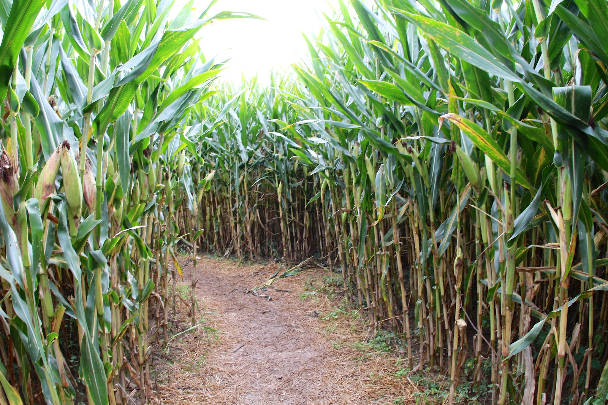 A corn maze in Northeast Ohio by David Fulmer, CC BY 2.0.
In OpenStreetMap, several corn mazes have been micromapped across Southwest Ohio. The designs change each fall, so the mazes have to be micromapped all over again.
Finding Wilson Boulevard
Posted by Minh Nguyen on 22 May 2017 in English. Last updated on 8 March 2026.(This post is cross-posted from a recent post on my blog and adapted for an audience already familiar with OpenStreetMap.)
An overflowing bánh mì, a tray of tender bánh da lợn, a can of soybean milk: my treat after every monthly trip to the little Vietnamese grocery across town. Mekong Market was my Sunday Bible school of Vietnamese culture in a childhood as distant from Asia as one could imagine, in Cincinnati. Snacks, sauces, and canned foods defying translation lined the shelves; in the refrigerator, a variety of mystery meats wrapped in aluminum foil each bore the same place of origin: Chicago.
One Labor Day, my family made a trip up to Chicago to finally see the bustling Vietnamese community whose clearance we had happily bought for years. We made a lot of road trips back then, often just spur-of-the-moment driving through the peaceful countryside. But since we were headed five hours away to an unfamiliar city, we needed to plan ahead. As the resident map enthusiast, I was to find directions to the Vietnamese supermarket in Chicago using our new Internet connection. We’d enjoy some phở for lunch and bring back enough fresh ingredients to avoid Mekong Market for a little while.
A search for “Vietnamese markets in Chicago” on AltaVista turned up an article from The Washingtonian describing a cluster of supermarkets, phở restaurants, and bakeries on Wilson Boulevard. I pasted the street address into MapQuest, specified “Chicago” and “Illinois” to make sure I got the right “Wilson”, and printed out the directions.