 OpenStreetMap

I build bike + train loops in France by crossing OpenStreetMap with the official cycling-route reference (RVM / Réseau vélo et marche). Two points I’d value the community’s view on: at which level the identity (ref) of a multi-level superroute should live, and whether the emerging ref:FR:RVM tag (which carries the RVM id and gives an exact OSM↔RVM join key) is worth spreading. Full write-up (FR): https://tisseurdevoies.fr/articles/openstreetmap-veloroutes-retour-experience
Users' Diaries
Recent diary entries
Posted by nicofr77 on 9 August 2026 in French (Français).
Last updated on 11 August 2026.
Je fais du vélo, j’aime rentrer en train, et j’ai fini par construire un outil qui repère les boucles réalisables entre deux gares. Pour ça, je croise les véloroutes d’OpenStreetMap avec le référentiel officiel des véloroutes françaises, RVM (Réseau vélo et marche).
J’ai documenté ce retour d’expérience (choix du référentiel, rapprochement des deux sources et reconstruction d’une géométrie exploitable) ici : OpenStreetMap et les véloroutes françaises : retour d’expérience de Tisseur de Voies
Je voulais surtout soumettre ici les deux points sur lesquels votre avis m’aiderait le plus.
1. Où placer l’identité d’un itinéraire dans une hiérarchie superroute / route ?
Les grandes véloroutes sont souvent modélisées avec plusieurs niveaux de relations.
La Route des Grandes Alpes, par exemple, a une racine type=superroute portant ref=VRGA, puis un « tracé principal » et des « variantes », puis les étapes. La structure est très utile, mais un consommateur qui ne traite que les relations feuilles type=route perd alors l’identité portée par la racine.
Sur la quarantaine de superroutes vélo que j’ai analysées en France, j’observe plusieurs situations : ref uniquement sur la racine, présent également sur certaines relations filles, ou parfois absent à certains niveaux.
J’ai trouvé différentes documentations et propositions sur les hiérarchies de routes, mais je n’ai pas identifié de convention suffisamment claire pour un consommateur de données :
dans une hiérarchie superroute / route, quelle duplication de ref, network et éventuellement name est aujourd’hui considérée comme souhaitable ?
L’objectif côté consommateur serait de pouvoir conserver à la fois l’identité de l’itinéraire et sa structure hiérarchique, sans déduire l’une à partir de l’autre.
Détail et exemple de la Route des Grandes Alpes
2. ref:FR:RVM : une clé de jointure OSM ↔ RVM ?

Today I finished mapping all the homes in the Stonebrae Country Club, a gated community surrounding a golf course at the top of the loop where Fairview Avenue becomes Hayward Avenue. In 2010 I worked as a NARFU Census taker and had to note down which addresses were inhabitable because they hadn’t been built yet. Now all that land with just paved streets are homes. Many of my children’s friends live there as they attended the elementary school across the street from the outer bounds of the neighborhood.
Next step is to start my way down Hayward Avenue and eventually into the heart of the city.
Posted by Seli Kasela on 8 August 2026 in Indonesian (Bahasa Indonesia).

Tourism and Digital Mapping: Research Digital
Google Maps Location
Image by Seli Kasela - Google Maps Location
SELI KASELA DIGITAL CREATIVE STUDIO
Jalan Pantai Balangan No.85
Jimbaran, Kec. Kuta Selatan
Kabupaten Badung, Bali 80361
Indonesia
Open SELI KASELA I in Google Maps
Digital Mapping and Tourism
This entry documents my personal work exploring the relationship between tourism, digital mapping, geographic information, and local destination discovery.
The location featured here is OSSY SURF TRIP BALI in the Balangan area of South Kuta, Badung, Bali, Indonesia.
Mapping Perspective
Digital maps are an important part of modern tourism. Travelers use geographic information to discover:
- Surf schools
- Beaches
- Hotels and accommodation
- Restaurants
- Local businesses
- Attractions
- Roads and transportation
- Points of interest
My interest is in documenting how local tourism places are represented within the wider digital mapping ecosystem.
OpenStreetMap and Local Knowledge
OpenStreetMap provides a collaborative environment for geographic information and community mapping.
This diary entry is part of my personal documentation of tourism, digital mapping, geographic information, and destination discovery.
Location Reference
Place: OSSY SURF TRIP BALI
Area: Balangan, South Kuta, Badung, Bali
Country: Indonesia
Topic: Tourism and Digital Mapping
Purpose: Personal work documentation
Looking 4 surrounding Flock action

I have already forgotten how I first came across StreetComplete, but what I do remember is that I immediately fell in love with the concept of the app.
I like wandering around and exploring. When travelling, the things that attract me the most are actually very “normal”. Maybe there is a neighbourhood, maybe a lovely park, maybe a path along the river… I just follow the direction of the road and take a turn at a junction if I feel like it.
I don’t know. I just really don’t like those crowded and buzzing tourist attractions. On the contrary, it is in the nooks and crannies of everyday life that I can feel the vibe of a neighbourhood, a town, or a city.
This convenience store has some good samosas. This small community park offers the best shade during the scorching summer. This path along the canal has ducks and geese to guide your walk…
From these small and seemingly negligible things, I feel a city comes alive.
And that’s why StreetComplete is my best travel companion. It pulls up a bunch of quests for me to explore. The surface of the pavement, the sound signal at a crossing, the bin at a bus stop, the name of a store… It simply guides me to dive deeper into an area, and I can explore while completing the quests along the way.
Gamification is a good way to encourage contributions to OSM, but for me, StreetComplete is far more than just a game. It lets me immerse myself into a city and teaches me how to look at it from a new perspective.
Is You Now We Started Adding A Lot Of New Stuff And Changes To R 8 Side And R 16 Side. R 8 Side Will Be Done At Aug 29th And R 16 Side Will Be Done On Last Day Of Sep.

··· I didn’t start contributing to OSM because of any grand philosophy or ideology. I simply began editing because I needed to. But as I became more involved, I learned more about what I believed OSM stood for—openness, decentralization, freedom to collaborate, and a community built around shared stewardship rather than commercial ownership. At least, that was how I came to understand OSM.
That understanding was what motivated me to continue contributing. I chose to spend my time improving OSM instead of Google Maps or the dominant commercial map used in my country. I even spent time studying OSM’s principles and community practices because I wanted to contribute in a way that respected those values.
If utility had been my only motivation, I probably wouldn’t have contributed to OSM at all. In the region where I live, almost nobody actually uses OSM. From a purely practical perspective, my efforts have very little visible impact. Yet I kept contributing because I believed OSM represented something fundamentally different from commercial mapping platforms. That belief—not efficiency or popularity—was what made my contributions meaningful.
For that reason, I don’t believe corporate participation is inherently a problem. OSM is open to everyone, and companies should absolutely be free to use the data and contribute to improving it.
My concern is not that companies participate. My concern is whether, over time, the priorities of the project could gradually shift toward the interests of organizations that naturally have business objectives and far greater resources than individual volunteers. Simply saying that “companies are part of the community” doesn’t fully address that concern. To me, the more important question is not whether companies belong here, but how the community ensures that the values and priorities shaped by volunteers remain just as influential as corporate interests.
Perhaps this is the source of my confusion.

Mapping
Over the past year, our OpenStreetMap Pakistan community has been actively working to map high-risk flood zones across the country—both areas historically affected by extreme flooding and regions facing critical vulnerability during upcoming monsoon seasons.
Shifting from Reactive Response to Proactive Preparedness
During last year’s monsoon floods, our mapping response began after the disaster had already struck. While those post-disaster edits were vital for ongoing emergency response, we recognised the need to get ahead of the curve.
This year, we shifted our strategy completely: we initiated pre-disaster mapping well before the monsoon season arrived.
By leveraging flood projections and high-risk zone data from the National Disaster Management Authority (NDMA) and prominent emergency monitoring sources, we identified priority regions across Pakistan. We began our efforts by focusing heavily on areas categorised as the highest risk of severe flooding, ensuring that digital infrastructure is in place before rising waters cut off communities.
Community Coordination & HOT Tasking Manager
Together with two fellow community members, I took charge of creating, organizing, and managing dedicated projects on the Humanitarian OpenStreetMap Team (HOT) Tasking Manager.
To drive contributions and sustain momentum, we have been organising community mapping parties and mapathons. Local mappers and volunteers across Pakistan came together to trace the following:
*Missing road networks and bridge connections
*Remote village footprints and building clusters
*Key natural landmarks and waterways
These precise layers are already empowering ground rescue teams, military logistics, and international aid agencies to plan evacuation routes, calculate population exposure, and navigate flood-affected corridors.
Global Recognition
Our community’s proactive mapping drive was recently highlighted in a feature article by the UK newspaper Oxford Herald:

This afternoon, I noticed that several of my colleagues were visiting a recently opened school in the far south.
They took several photos, which is quite a rarity on the internet, since not many people actually go there and upload pictures of the newly built buildings.
I wanted to upload those photos, hoping they might be useful for anyone trying to find information about the place.
Then I remembered that OpenStreetMap has this image=* tag.
I could associate an image with the place by adding an image URL there. So I opened Vespucci on my Android phone and added the image URL to the object.
Now I’m back at my PC, and I wanted to make a simple app (or maybe just a script) to browse every image=* tag that exists in OpenStreetMap.
At first, I thought of doing it the usual way : build a Leaflet web map, query the Overpass API, then display the images in popups.
But then I remembered that the Overpass API has recently been under heavy load.
From what I’ve heard, it’s because of a barrage of AI scrapers… or maybe just a flood of quick-and-dirty, vibe-coded OSM apps being produced en masse.
Whatever the exact reason, it has noticeably affected the service.
Knowing that, I was discouraged from making the situation any worse. So I scrapped that idea.
Then I remembered something else:
I don’t know exactly how it works internally, but I assume it uses a different Overpass API endpoint than the ones I would normally query directly.
If that’s the case, perhaps using Ultra wouldn’t add to the current strain on the public Overpass servers.
I also realized that Overpass Ultra’s advanced styling syntax lets me solve the whole problem directly within the query itself, without having to build my own Leaflet-based web app.
So here it is: a quickly put-together Ultra query that displays every OpenStreetMap object containing an image=* tag and shows the referenced image in a simple popup.
I’m on my mobile phone, and l find it the most useful tool. If l must work on OSM from the laptop, l’d have to do it offline. For that, l’d have to download the josm offline map, after locating the coordinates.
05/08/’26 01:18

Öneri, talep ve şikayetleri yorum olarak tarafımıza iletebilirsiniz. En kısa sürede talebinizi işleme alacağız.
You can submit your suggestions, requests, and complaints to us via comments. We will process your request as soon as possible.
On a silver post on the NE corner of Hwy 64 and 285

Life in a multi-million population City can be tough on Introverted minds. For me, mapping in OpenStreetMap is first and foremost an activity to improve publicly accessible geodata around my local and known places, though it has also recently become a way for me to virtually travel to far away places. Exploring remote corners of the earth that are not quite as bustling with activity, where not every square-meter has already been meticulously mapped to the nth degree. Theres even a subreddit for this kind of exploration: /r/GoogleEarthFinds !
Zooming in on a random patch of rainforest, a tiny island in the pacific or one of the thousands of meandering arms off the Amazonas shows a mostly untouched view of nature. Panning around looking for interesting landmarks, it only takes a few minutes to stumble upon a secluded village whose roads are not even connected to the world-wide network, or a lonely farm in the middle of nowhere. These are the places that fascinate me the most. I get lost in imagining what life is like there, who lives there, what untold stories do these places hold? While daydreaming of this, i map the buildings I see, paths and roads, things that can safely be confirmed from aerial imagery. Switching to different imagery providers can show how these places evolved, has the village grown or shrunk? Have Roads been extended or left to be reclaimed by mother nature? A handy website for viewing satellite imagery with different timestamps is https://livingatlas.arcgis.com/wayback
Usually I just zoom into random places and see where it takes me. With the power of Overpass Turbo, one can find places in a slightly organized fashion. Below is a prompt which shows islands that have residential areas on them, within the current view of the map:
[out:json][timeout:25];
(
nwr["place"="island"]({{bbox}});
  );

nwr["landuse"="residential"]({{bbox}});

// print results
out geom;
Or simply highlighting villages in the current map view:
August 2–8
August 2
- Fixed Reynoldsburg borders; borders now up-to-date as of most recent annexation on May 24, 2026.
- Updated Reynoldsburg population; increased to 43,350 according to U.S. Census Bureau.
- Added intermittent stream called Little Jordan Run.
- Modified Jackson Avenue; changed “one way” value to “no” and added note that signage by the Street Department is incorrect. Correct name is Jackson Avenue not Jackson Street.
- Modifed Burkey Avenue; changed “one way” value to “no” and added note that signage by the Street Department is incorrect. Correct name is Burkey Avenue, not Burkey Drive.
- Modified Burkey Court; switches from Burkey Avenue to Burkey Court at the intersection with Southwood Avenue, not in the middle of the road.
- Fixed name of Taylor Park Drive (originally shown as just “Taylor Park”).
- Fixed differentiation between Taylor Road and Taylor Road Southwest.
- Added info to Raider Stadium (Reynoldsburg High School football stadium).
- Removed Smokey Bones brand from building at 2200 Baltimore-Reynoldsburg Road (closed permanently after bankruptcy).
- Added info to Reynoldsburg High School’s Livingston Campus.
August 3
- Fixed name of Taylor Road.
- Added 5 ponds near Lakeland Hills neighborhood.
August 5
- Added name of TS Tech Drive as indicated by street signs in the area.
- Added name to the remaining portion of Wilma Drive.
August 9–15
August 9
- Removed nonexistent Truro Township enclave inside Reynoldsburg around Blacklick Creek.
August 16–22
August 20
- Added French Run (aka French Run Creek).
- Removed note about Burkey Avenue incorrect signage (fixed with new signage).

To-do: Add bus route 42 stops through Highton and Belmont. Will be referring to McHarry’s route map and ensuring match with Transport Victoria resources.
Posted by evyy on 1 August 2026 in German (Deutsch).
Gerade eben mappe ich den Bayern-Park detaillierter. Durch meine frühere Jahreskarte konnte ich den Park oft besuchen und kenne daher viele Bereiche aus eigener Erfahrung. Jetzt nutze ich dieses Wissen, um Details des Parks in OpenStreetMap zu verbessern.
Als Ziele habe ich folgende:
- Alle POIs überprüfen und ggf. eintragen/aktualisieren
- Alle (oder zumindest den größten Teil von allen) Wege überprüfen und ggf. hinzufügen/aktualisieren
- Generell mehr Details hinzufügen

I am currently focusing my mapping work on the Taiping Heritage Zone. Most of the shoplot footprints and major buildings have been completed, and I am now working on detailed micromapping for schools, museums, and government buildings.
Please feel free to contribute by adding any missing information, such as shop or stall names, building levels, address numbers, or other relevant details that I may have missed.
Let’s work together to make Taiping one of the most complete and detailed small-town maps in Malaysia on OpenStreetMap.

As explained in this french diary entry I left a bunch of notes, took a bunch of traces while visiting Mongolia in July. The main reason, was that I was playing with StreetComplete and firing Vespucci would have annoyed my wife adding notes was easier. So I left notes, for later. Today I decided to start editing based on my memory and some of the notes. While editing, I saw a very high number of these in the center of UB.
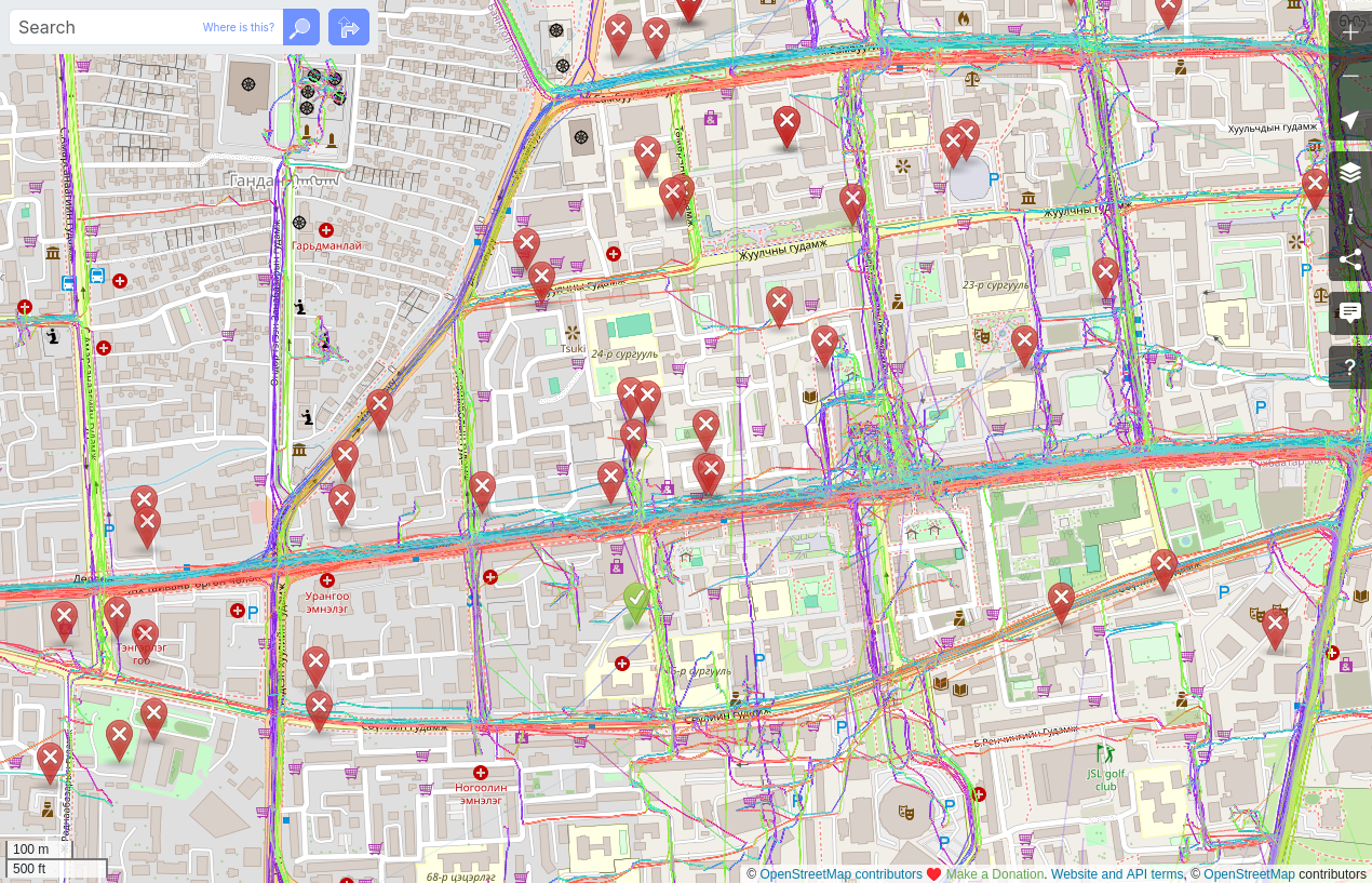
Many are old, and the imagery is old. Is there a process to clean up notes? Are there people willing to spend time taking these notes and making the edits that for some are probably needed?

この diary は アカウントロックされた経緯の説明 の関連記事です。
DWGが仕事をしていないようなので催促しました
Glassmanによる不当なアカウントロックと ‘int_name’の大量削除問題 を3月に「通報」したのですが、なんの進捗もないようなので催促のメッセージを送りました。 osm.org/user_blocks/19857
原文はこちらです(英語)
Re: 2026年08月 1日 04:27
日本のコミュニティ向けに日本語の翻訳を示します。
[Ticket#2026013110000088]https://www.openstreetmap.org/messages/1338706
DWG(Data Working Group)への声明(日本語訳)
DWGの皆様へ
まず、返信が遅れたことをお伝えいたします。
この遅延は意図的なものであり、int_name に関するコミュニティフォーラムでの議論が一定の段階に達し、適切な説明が可能になるまで待つ必要があったためです。
https://community.openstreetmap.org/t/key-int-name-must-be-deprecated/142316/49
この期間中、DWGからのコミュニケーションにおいて重大な誤解が存在することが明らかになりました。
DWGは、私 hayashi を別のマッパー「無限の刃」と繰り返し混同しています。
この誤認により、本来別の人物に向けられるべき指摘や警告が私に対して送られ、DWGのメッセージには一貫性がなく、対応不能な状態が続いていました。
私は hayashi です。
私は 無限の刃 ではありません。
int_name の削除を提案し、実際に削除を行ったのは 「無限の刃」氏であり、私ではありません。
1. 「あなたの主張」という誤った認識について
DWGは以前、次のように述べています。
> I'm not sure you have people convinced with your argument.
> あなたの主張で人々を納得させられたかどうかは、定かではありません。
しかし、この評価は事実に反しています。
-
int_nameの廃止を主張したのは 「無限の刃」氏 です。 -
int_nameを大量削除したのも 「無限の刃」氏 です。 - 日本コミュニティからの警告を無視したのも 「無限の刃」氏 です。
- この行為を通報したのは 私 hayashi です。
私は int_name を削除していません。
私は int_name の廃止を主張していません。
私はただ、int_name を廃止する理由を質問しただけであり、その質問には一度も回答がありません。
参照: https://community.openstreetmap.org/t/key-int-name-must-be-deprecated/142316/38
さらにコミュニティフォーラムでは:
- 「無限の刃」氏の提案を支持する投稿は 一つもありません
- 私の意見を「一方的」と批判する投稿も 一つもありません
- 多くのマッパーが「無限の刃」氏の一方的な行動に懸念を示しています
DWGが「私の主張がコミュニティを説得できていない」と述べたのは、人物の取り違えによる誤認です。
2. 私への「コミュニティ参加の推奨」を繰り返すのはやめてください
DWGは繰り返し、私に「ローカルコミュニティに参加するように」と促しています。
これは不適切であり、直ちにやめるべきです。
私は長年、日本のOSMコミュニティに積極的に参加してきました:
osm.org/user/hayashi/diary/408467
日本コミュニティではすでに:
-
name:enの用法が議論され - Wikiに合意内容がまとめられ
-
int_nameの扱いについても共通理解が形成されています
DWGが私に「コミュニティのフィードバックを求めよ」と指示するのは、以下の事実を無視しています:
- コミュニティの合意はすでに存在する
- 私はその合意形成に参加している
- コミュニティ参加を拒否しているのは 「無限の刃」氏である
DWGの繰り返しの指示は、日本コミュニティの実態を把握していないことを示しています。
DWGは次のようにも述べています:
> What is the most active Japanese community discussion place?
> 日本コミュニティの主要な議論場所はどこか?