
About eight months ago I started mapping my hometown, and earlier today I reached a major milestone of having gone over everywhere boxed in by the Sabine River Diversion Canal and the CPKC railroad. I’ve gotten a lot more detailed and generally more accurate with mapping, so rather than moving on I’m going to do a (hopefully much quicker) second pass, particularly for where I did not yet start using street-level imagery to verify road names, building/business names, and other micromapping targets I like to do (an embarrassing number of power poles and street lamps). I expect to have every road de-tigered and every visibly signed POI named sometime next year. From that point on I think I’ll focus on de-tigering the rest of the road network in the parish, then maybe start mapping other nearby towns.
Users' Diaries
Recent diary entries

As part of the Ireland chapter of OpenStreetMap a few years ago I set up a tileserver and a map frontend that defaulted to showing placenames in the Irish language (Gaeilge). Recently I spent some time improving both these services.
Vector Tileserver
Previously the default style was named ‘ga’ and available at: https://tileserver.openstreetmap.ie/styles/ga However, last weekend I added a new ‘style’ named ‘sraid-v1’. You can take a look at it here: https://tileserver.openstreetmap.ie/styles/sraid-v1/ The screenshots below show a comparison. The new style is much brighter and has icons generated from Maki icons into a sprite sheet (see generate_sprites.py in the github repo). I also fixed a few things I didn’t like about the old ‘ga’ style.
If you are currently using tiles from tileserver.openstreetmap.ie and want to use the new ones, you will need to change the code where it currently points to:
https://tileserver.openstreetmap.ie/styles/ga/
You can now use:
https://tileserver.openstreetmap.ie/styles/sraid-v1/
So to use this vector tileset you might use something like the code below with MapLibreGL
var map = new maplibregl.Map({
  container: 'map',
  style: 'https://tileserver.openstreetmap.ie/styles/sraid-v1/style.json' + keyParam,
  hash: true,
  maxPitch: 85
});
The previous style ‘ga’ is still present so there should be no breaks in functionality if you choose to continue using the old style.
The code is available here: https://github.com/jonnymccullagh/irish-language-osm-tiles
Léarscáil
Dear OSM users,
I need to inform you that, unfortunately, the Toledo Province area is quite neglected and lacks detail. This isn’t anyone’s fault, obviously; it’s something that needs improvement, and together we can fix it. Furthermore, one of the most populated areas of Toledo, the La Sagra region and its surroundings, lacks updates and good features. We also cover the southern Madrid area, which also lacks updates.
WE NEED PEOPLE WHO CARE ABOUT THIS AREA.
LET’S DO SOMETHING BIG.
Thanks for reading.
Queridos usuarios de OSM
Necesito comunicaros que por desgracia la zona de la Provincia de toledo esta bastante abandonada y con pocos detalles esto no es culpa de nadie obviamente es una cosa a mejorar y que todos unidos podemos arreglar ademas una de las zonas mas pobladas de toledo la provincia de la sagra y alrededores carecen de modificaciones y buenos detalles tambien abarcamos la zona del sur de madrid que tambien carece de actualizaciones
NECESITAMOS GENTE QUE LE PREOCUPE LA ZONA MENCIONADA
HAGAMOS ALGO GRANDE
Gracias por Leer

Nuestro estimado Sanchi, Borra cosas que ni sabe si estan bien sin control. Porfavor si os judga,elimina u os hace algo parecido porfavor contactar conmigo. Muchas grracias por su colaboracion
He tenido que añadir muchas cosas a este lugar durante mi jornada laboral. Necesito a alguien que, conmigo, añada a Getafe lugares que aún no están en el mapa. Por favor, escríbanme en privado para decirme quién quiere colaborar en este proyecto llamado: ¡Ayudemos a Getafe! Avísenme si les interesa. Leeré sus mensajes. Adiós, Kitsunderoku
Por favor escribidme si estáis convencidos de que Getafe necesita editores y uniros a mi para mejorar OpenStreetMap en Madrid.
I was checking the map in all of the world and i see things that broke my eyes. I never been there but the things i found are don’t common.
I had to add so many things to this place during my courent day in the job. I need someone that with me add to Getafe some things that there aren’t on the map. Please, write me in private to let me now who want to colaborate in this proyect that is name: Lets help Getafe!!!! Let me now who is interesed writting me. I will read your menseges. Bye Kitsunderoku
More recently I find myself addicted to OSM once more after a long hiatus. I guess working in the civil road design space has me interested in capturing features around the streets such as crossings, sidewalks, street furniture and recreation spaces.
I’m shocked by the number of sidewalks I have found that cross a street not as a crossing. I’m fixing these as I find them.
My end goal is to try and resolve as many items from StreetComplete as I can around where I live and work, adding to the accuracy of the overall map model locally.
Neue Edits
Da ich Organic Maps am Handy nutze und entdeckt habe, dass manche Informationen oft jahrealt und überholt sind, bearbeite ich nun wieder OSM.
Sammlung - öffentlich zugängliche Klavier
Eine Idee, die ich umsetzen will, ist eine Art Übersichtskarte von öffentlich zugänglichen Pianos und Flügeln. Ich finde es selbst oft sehr reizvoll beim Reisen, wenn man als Musiker ein freistehendes, öffentlich zugängliches Instrument wie ein Klavier entdeckt und darauf spielen darf.

Collaborating to add verified information to OpenStreetMap can significantly improve global navigation and community planning. I am a firm believer that each contribution helps create a more accurate, accessible, and connected world. Together, we can truly make a difference!
LostAlone
Having grown up in the Current River Area there are many same details I was able to add to the map such as small back roads that are mainly used my locals. Additionally one thing I noticed with is that many features where outdates. There where restaurants and stores that closed down years ago and new ones have since opened up in their place. So I updated the map to have the newest data. From using openstreetmap I learned a lot about citizen mapping and the people who live in an area know it the best to map it. But also using a mapping website open to the public comes with risks of inaccuracies. What I found to be challenging was that some houses weren’t properly lined up so it impacted when I tried to add a new house.
… and following on from the previous entry, Maps for Garmin devices at map.atownsend.org.uk now show crossing details too:
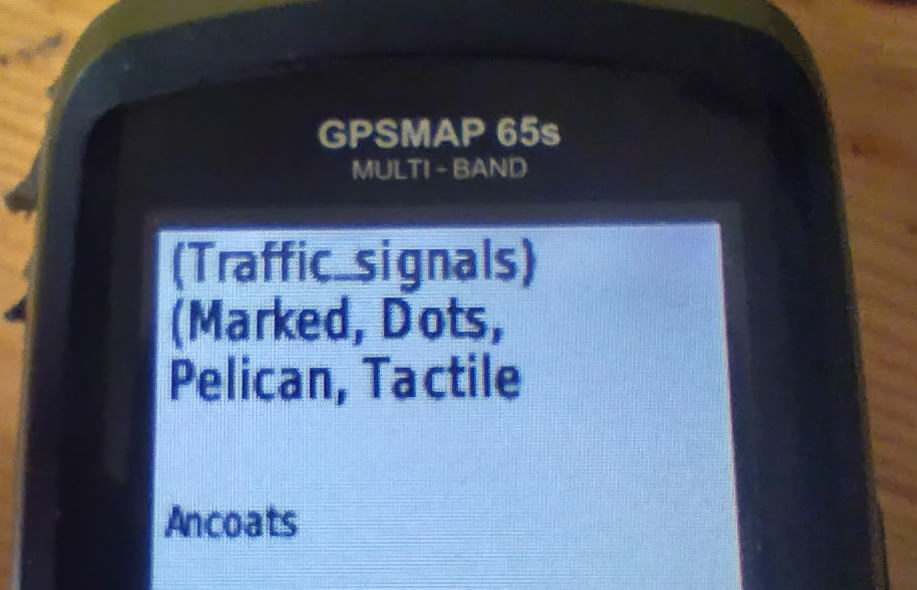
The following tags from the top-level feature are shown:
-
traffic_signalsorcrossing - The value of
crossingif it adds extra information - The value of
crossing:island,crossing:marked,crossing_refetc. if they add extra information. - Information from
tactile_pavingandkerb.
All of this might be truncated for length (it is here), but the most important information does appear.

خانه محل زندگی

Requisitos
- Plugin areaselector
- Plugin Scripting
Em locais onde o contraste de cores é bem definido, você pode usar o plugin areaselector para adicionar áreas de forma mais ágil — basta apenas um clique.
O contorno ficará com uma aparência serrilhada, com ângulos de 90°.
O segundo passo é fazer uma suavização usando o plugin Scripting, com o código disponível aqui.
I am a new editor of OSM, and I thought I would explore the tools and update familiar areas for myself. I added and updated areas in Bronte Creek Provincial Park. The OSM tools made it really easy to add new areas, points of interest, add some walking trails and label everything with accurate details. The park was already mapped with buildings, trails, roads, parking lots and much more. A lot of what I found myself doing was adding newly labelled areas, ex. Cow Barn, Cow Pasture. I am very familiar with BCPP, and now anyone looking to go to the park can have a better idea of what is really there. OMS is very easy to navigate, and I enjoyed using this mapping software. Not only is it a great tool to add for other people to use, but it is also great to see what is really in your surroundings.
Ivan ha pubblicato recentemente una mappa dei CAP fatta da koriander sul gruppo Telegram @OpenStreetMapItalia.
Saltava subito all’occhio che c’erano diversi errori nei dati sorgenti su OSM. Perciò ho iniziato a fare delle query con overpass turbo per trovarli.
La prima cosa che ho fatto è stata quella di fare una query per trovare valori del tag addr:postcode che iniziano con una lettera diversa rispetto all’area geografica in cui si trovano. Ad esempio, in Piemonte, i CAP iniziano tutti con “1”, a eccezione delle province di Novara e del Verbano-Cusio-Ossola.
Ho scoperto che alcuni indirizzi sono stati copiati dal web. Di per sé non è un problema, ma lo diventa se il mappatore non capisce che il POI che sta aggiornando non è quello recuperato su Google e quest’ultimo si trova invece a centinaia di chilometri di distanza. Ad esempio questo, questo e questo.
Poi ho fatto una query che restituisce i CAP sintatticamente errati, ovvero che non sono composti da 5 cifre.
Ho così trovato che molti degli attracchi dei vaporetti a Venezia avevano un CAP (!!). La cosa più strana è che il valore era sempre “30121-30176”.
A guardare bene, però, questo fenomeno non era limitato a Venezia. Continuavo a trovare CAP in questo formato in tutto il Nord-Est e non capivo perché. Tra l’altro il tag “addr:postcode” era stato inserito anche nei posti più assurdi (fermate del vaporetto, monumenti ai caduti, ecc).
Poi ho avuto una illuminazione: il dato è stato copiato da Wikipedia senza alcuna verifica.
Dopo aver analizzato un po’ di changeset ho notato che TUTTI gli edit sono stati fatti con Organic Maps.
Ho quindi scoperto che Organic Maps compila automaticamente il CAP prendendo il dato da Nominatim, che a sua volta lo prende dal tag postal_code.
Tutti questi tag postal_code sono stati aggiunti dallo stesso utente nel 2023 (ovviamente copiandoli da Wikipedia).
Fine storia triste.
I cycle around town a lot and I’d like people to join in. One of the barriers to entry is finding safe routes so I thought I’d try and update the map with the cycle infrastructure as it is built.
I was also pointed at StreetComplete so I’ll log more metadata in my area as I wander about.