ok
Users' Diaries
Recent diary entries
Another year has passed since my last entry, and it’s about two years ago that I resided in Bonaire for half a year. I want to visit again, but there’s that man on the side of my shoulder whispering things about a sustainable world :) (Meaning I can’t simply visit for a couple of weeks, but should stay for a longer period of time.)
Last year (2024), the Dutch government made high resolution aerial photos of Bonaire. I’ve already updated and mapped several areas based on this. As this information is both high resolution and recent it is very useful for mapping. You can find more information about this on https://www.beeldmateriaal.nl/dataroom-caribisch-nederland
In 2023 I stayed at the Hausmann Follies apartment complex. To compare the image quality, look at these photos:
Bing resolution:

Posted by AndreaDp271 on 13 August 2025 in Italian (Italiano).
Oggi 13/08/2025 ho creato il primo post sotto il mio profilo proponendo nuovi tags per gestire le aree della protezione civile, ben diverse dai punti di raccolta
EN
Hi there, and thanks a lot for your contribution! 🌟 Just a little tip for future edits: keeping changesets small and local can make things smoother for everyone. It helps prevent conflicts, makes it easier for fellow mappers to review, and keeps the map even more accurate.
A few friendly suggestions: • Focus edits within a small geographical area (like a single city, district, or province) • Try not to mix far-apart locations in one changeset • Save/upload before starting work in a totally different area
If you’re curious, the wiki explains more here: osm.wiki/Changeset#Geographical_size_of_changesets
Thanks again for your mapping energy, and happy mapping! 🗺️
Why is it important to remind both new and experienced users to keep changesets limited to a specific area? First of all, not all editors can handle loading large amounts of data, as happens with iD (link). More importantly, a large bounding box (covering, for example, half the world or all of Northern Italy) makes it harder for other mappers—both local and remote—to review the changes, even when using modern tools like Better OSM or OsmCha.
IT
Ciao, e grazie mille per il tuo contributo! 🌟 Un piccolo suggerimento per i prossimi cambiamenti: mantenere i changeset piccoli e localizzati può rendere il lavoro più semplice per tutti. Aiuta a evitare conflitti, facilita la revisione da parte degli altri mappatori e mantiene la mappa ancora più accurata.
Alcuni suggerimenti amichevoli: • Concentrati su un’area geografica ristretta (come una singola città, un quartiere o una provincia) • Evita di mescolare località lontane nello stesso changeset • Salva/carica prima di iniziare a lavorare in un’area completamente diversa
Se sei curioso, la wiki spiega di più qui: osm.wiki/Changeset#Geographical_size_of_changesets
Grazie ancora per la tua energia nel mappare e… buona mappatura! 🗺️

吉林省普通公路2023版
两环
G102、G229、G302、G334长春过境段新线=长春半小时环线
S001长春经济圈环线
两射
S101长吉线(长吉北线)
S102长双线
八横
G331丹东-阿勒泰
G503五常-通榆
S3??山河-太平川
G302珲春-阿尔山
G334龙井-东乌珠穆沁旗
G503抚松-公主岭+G608扎赉特旗-公主岭=抚松-扎赉特旗
G303集安-阿巴嘎旗
G333三合-莫力达瓦旗=莫力达瓦旗-三合
十二纵
S2??穆棱-珲春
S2??绥芬河-二道白河
G201鹤岗-大连
G222嘉荫-临江
G202黑河-大连
G229饶河-盖州
G102北京-抚远
G203绥化-沈阳
G232牙克石-四平
S2??王府-新宾
S2??齐齐哈尔-通榆
S2??嫩江-双辽
三十七联
S5??复兴-分水岭
S5??汪清-东宁
G610珲春-沙坨子
S5??三道湾-龙井
G611和龙-南坪
S5??敦化-和龙
S5??松江-露水河
S5??和平营子-天池北
S5??天池南-长白
G606五常-敦化
S5??天池西-松江河
S5??蛟河-凤凰山
S5??松花湖旅游环线
G612漫江-临江
S5??舒兰-陶赖召
S5??舒兰-大口钦
S5??桦甸-朝阳山
S5??辉南-三道沟
S5??白山-西丰
S5??石人-通化
S5??通化-桓仁
S5??烟筒山-辽源
G230通化-武汉
S5??营城子-小四平
G607哈尔滨-松原
S5??查干湖旅游环线
S5??秦家屯-八面城
S5??四平-杨木林子
S5??镇赉-莫莫格
S5??前七号-太平川
S5??到保-突泉
S5??通榆-向海
S5??洮南-科尔沁右翼前旗
S5??洮南-向海
G609珲春-珲春口岸
G506集安-本溪
- 吉林省标准地图
- 吉林省干线公路网规划(2022-2035年)
- 2014年-2030年吉林省省级公路网规划
- 吉林省普通国省道网布局方案示意图
- 吉林省高速公路网布局方案示意图(2014-2030)
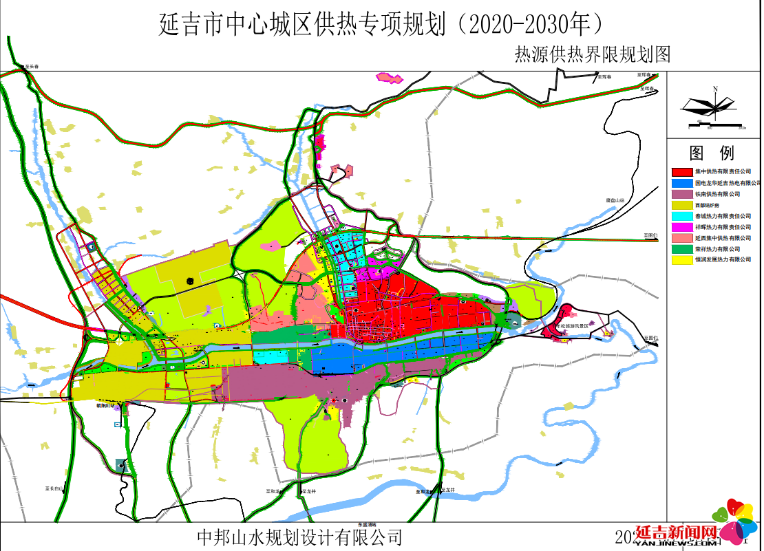
- 延吉市中心城区供热专项规划
- 延吉市学区调整图
- 延吉市国土空间生态修复规划
- 小营镇国土空间规划(2021–2035年)
- 依兰镇国土空间总体规划(2021–2035年)(无图)
- 三道湾镇国土空间总体规划(2021–2035年)(无图)
- 敦化市大石头镇国土空间总体规划(2021-2035年)
- 敦化市黄泥河镇国土空间总体规划(2021-2035年)
- 敦化市官地镇国土空间总体规划(2021-2035年)
- 敦化市沙河沿镇国土空间总体规划(2021-2035年)
- 敦化市秋梨沟镇国土空间总体规划(2021-2035年)
- 敦化市额穆镇国土空间总体规划(2021-2035年)
- 敦化市贤儒镇国土空间总体规划(2021-2035年)
- 敦化市大蒲柴河镇国土空间总体规划(2021-2035年)
- 敦化市雁鸣湖镇国土空间总体规划(2021-2035年)
- 敦化市江南镇国土空间总体规划(2021-2035年)
- 敦化市黑石乡国土空间总体规划(2021-2035年)
- 珲春市国土空间总体规划(2021-2035年)
- 珲春市春化镇国土空间总体规划(2021-2035年)
- 珲春市敬信镇国土空间总体规划(2021-2035年)
- 珲春市板石镇国土空间总体规划(2021-2035年)
- 珲春市英安镇国土空间总体规划(2021-2035年)
- 珲春市马川子乡国土空间总体规划(2021-2035年)
- 珲春市杨泡满族乡国土空间总体规划(2021-2035年)
- 珲春市三家子满族乡国土空间总体规划(2021-2035年)
- 珲春市密江乡国土空间总体规划(2021-2035年)
- 珲春市哈达门乡国土空间总体规划(2021-2035年)
- 龙井市国土空间总体规划(2021-2035年)
- 龙井市矿产资源总体规划(2021–2025年)
- 龙井市生态修复规划(2021–2035年)
- 龙井市智新镇国土空间总体规划(2021–2035年)文本
- 龙井市智新镇国土空间总体规划(2021–2035年)图纸
- 龙井市白金乡国土空间总体规划(2021–2035年)
- 龙井市德新乡国土空间总体规划(2021–2035年)
- 安图县国土空间总体规划(2021–2035年)
- 安图县明月镇国土空间总体规划(2021–2035年)
- 安图县松江镇国土空间总体规划(2021–2035年)
- 安图县二道白河镇国土空间总体规划(2021–2035年)
- 安图县两江镇国土空间总体规划(2021–2035年)
- 安图县石门镇国土空间总体规划(2021–2035年)
- 安图县万宝镇国土空间总体规划(2021–2035年)
- 安图县亮兵镇国土空间总体规划(2021–2035年)
- 安图县新合乡国土空间总体规划(2021–2035年)
- 安图县永庆乡国土空间总体规划(2021–2035年)
Posted by martien-176 on 12 August 2025 in English.
Last updated on 13 August 2025.
Introduction
Humanitarian Openstreetmap Team (HOT) is an international team dedicated to humanitarian action and community development through open mapping.
Accurate and up-to-date data is essential for effective humanitarian response. Validators use tools such as JOSM and the HOT Tasking Manager to identify and flag errors and mistakes. From experience, i know that this is a complex and time-consuming endeavor.
One tool to save time and enhance the validation process is OSMCha.
The funding for OSMCha is currently at risk, which could lead to the degradation of this invaluable tool. In this diary, i want to highlight the essential role OSMCha plays in my own (and other’s) validation and quality maintenance workflow.
What is OSMCha

OpenStreetMap Changeset Analyzer (OSMCha) is a tool designed to monitor and analyze changes made to OpenStreetMap data. It enables data validators to quickly identify potential issues, track changes, and ensure data quality.
peraia δευκαλιωνος 35
Posted by dierfort on 12 August 2025 in Russian (Русский).
Last updated on 28 August 2025.
Здание ГИБДД заброшено.
Координаты 57.189472, 39.42346

Posted by Muhamad Fahri Mulyawan on 12 August 2025 in Indonesian (Bahasa Indonesia).
Halo, saya Mulyawan asal Indonesia, aktif di OpenStreetMap
Здание заброшено,
Ростовский МО МВД переехало на ул Февральская .

Posted by dierfort on 11 August 2025 in Russian (Русский).
Last updated on 28 August 2025.
Координаты
57.190312, 39.427535
Дом снесён

Ярославская область, город Ростов Великий, улица Бебеля Координаты 57.190766, 39.428734, Дом сгорел полностью, место заросли кустарники, деревья

In collaboration with a local team in Grünstadt, Mannheimer Mapathons e.V. completed the mapping of the historic Jewish cemetery in early 2024 after five months of data collection. The cemetery was used by the important Jewish community from around 1700 to around 1937 and comprises 464 gravestones that are still visible. A high-precision Sparkfun RTK Facet GPS receiver was used for the survey. A map has been available online since May 2024. In recent weeks, with the support of the Heidelberg University of Jewish Studies, the names and dates of many of the oldest purely Hebrew gravestones have been catalogued and integrated into the map data. The translation work will continue with the aim of supporting both descendants and historical research.
In Zusammenarbeit mit einem lokalen Team in Grünstadt hat Mannheimer Mapathons e.V. nach fünf Monaten Datenerhebung Anfang 2024 die Kartierung des historischen jüdischen Friedhofs abgeschlossen, berichtet RCD49. Der Friedhof wurde von der bedeutenden jüdischen Gemeinde etwa von 1700 bis ca. 1937 genutzt und umfasst 464 noch sichtbare Grabsteine. Für die Erfassung kam ein hochpräziser Sparkfun RTK Facet GPS-Empfänger zum Einsatz. Seit Mai 2024 ist eine Karte online verfügbar. In den letzten Wochen wurde mit Unterstützung von der Hochschule für Jüdische Studien in Heidelberg begonnen, Namen und Daten von vielen der ältesten rein hebräischen Grabsteine zu erschließen und in die Kartendaten zu integrieren. Die Übersetzungsarbeit wird fortgesetzt, mit dem Ziel, sowohl Nachkommen als auch historische Forschungen zu unterstützen.
Posted by JWillLabrador on 10 August 2025 in English.
I have continued mapping Happy Valley Goose Bay. I noticed that the ESRI world imagery isn’t particularly good. I could do with some more or better data, and I may have to do some drone flights to get it.
I have also started to reach out for data in the surrounding towns.

Bliss
133000延吉市区(进学、新兴、北山街道)、小营镇东郊部分(光明、光进、小营、新光村)
133001延吉市区(河南、建工街道)、小营镇南郊部分(东光、东新、东明、东风、仁坪、吉兴、新光、新农、河龙、理化、长东)
133002延吉市区(公园街道)、小营镇西郊部分(民主、吉兴、果树村),依兰镇北郊部分(发展、大成、实现村)
133003依兰镇(原烟集乡下辖的兴农、利民、台岩、龙渊村)
133004依兰镇(九龙、古城、平安、春光、东兴、北大村)
133005三道湾镇(镇区、五道、梨树、东沟、平岗村)
133006三道湾镇(南张芝、北张芝、屯田、支边村)
Posted by NaufalFarras on 10 August 2025 in Indonesian (Bahasa Indonesia).

Transjakarta, jaringan rute Bus Raya Terpadu (BRT) terpanjang di dunia ini menjadi tulang punggung transportasi umum di dalam Kota Jakarta. Dengan ratusan rute dan ribuan kendaraannya, Transjakarta menjadi bagian penting dalam identitas Kota Jakarta. Namun sayangnya, data rute dan infrastruktur pendukung Transjakarta kurang diminati untuk dipetakan. Hal ini mendorong saya untuk memetakan Transjakarta, setidaknya jaringan koridor utamanya terlebih dahulu.
Mengenal sistem Transjakarta
Transjakarta merupakan sistem jaringan bus kota di Jakarta. Ditinjau dari rutenya, rute Transjakarta terbagi menjadi dua, yakni rute BRT dan non-BRT. Rute BRT merupakan rute yang berjalan sepenuhnya di jalur khusus dan hanya berhenti di halte BRT. Sementara itu, rute non-BRT merupakan rute bus kota yang melayani halte di pinggir jalan dan biasanya tidak melewati jalur khusus. Sebagian kalangan membagi lagi rute non-BRT menjadi rute non-BRT yang juga melayani halte BRT dan rute yang sama sekali tidak melayani halte BRT (sepenuhnya melayani halte biasa di pinggir jalan).
Jalur khusus yang dimaksud pada kenyataannya tidak benar-benar “khusus”. Sebagian jalur khusus memang memiliki pembatas atau separator untuk memisahkan jalur untuk bus dan kendaraan lain. Namun, sebagian lainnya hanya berupa jalan yang diberi marka, sehingga pada kenyataannya juga dipakai oleh kendaraan lain. Sebagian lainnya bahkan tidak memiliki penanda apapun, sehingga bus “BRT” berjalan di jalan yang tidak memiliki perlakuan khusus apapun terhadap bus Transjakarta.
This is a compilations of what I sent to other people.
I have taken it from the cadastre at (https://seduvi.cdmx.gob.mx/programas-delegacionales-de-desarrollo-urbano), I was extremely surprised that CDMX’s cadastre has not being used because it is in the public domain (“Este programa es de carácter público, no es patrocinado ni promovido por partido político alguno y sus recursos provienen de los impuestos que pagan todos los contribuyentes.”) You only need to credit the source: “Agencia Digital de Innovación Pública “Sistema Abierto de Información Geográfica (SIGCDMX)” Disponible en: https://sig.cdmx.gob.mx/”.
After reading osm.wiki/Import/Guidelines, I will make a import page for CDMX data to serve as a documentation for where the data comes from.
Step 1
I download the data from (https://sig.cdmx.gob.mx/datos/descarga). There are two types of data there, the actual cadastry data “Descarga de datos del catastro” and landuse data “Descarga de datos SEDUVI”. The cadastry data is basically a bunch of points and I find that the only useful data there is the address data, which is fairly inaccurate.
It is better to download the landuse data since it has the polygons to work with. I download the shapefile from the “Descarga de datos SEDUVI” section. I’m working at Cuauhtémoc alcadia because it is the central alcadia of CDMX
Generally, since houses in Mexico are connected to each other, often the landuse is the building footprint itself. But, for more complex places like schools, churches, hospital, government areas, etc. it only covers the surrounding of the complex.
Step 2

휴식을 취하고 거북섬을 지도에 표시했습니다.