
Back in March I posted a diary entry proposing to add basic support for disputed borders point-of-view (aka worldview) to OpenStreetMap. I was able to complete that work, primarily in March, April, May, and June of this year, by adding disputed=yes, disputed_by=*, claimed_by=*, and recognized_by=* tags. More work remains (see below), please contribute!
The open source Tilezen project was updated in June in v1.8 (changelog) to add support for the OpenStreetMap tags (view source). The Nextzen vector tile build now includes that data with circa 2019-July OSM planet file. Props to @Matt for the extensive work this entailed.
I released a new version of the Bubble Wrap map style for Tangram, using the Nextzen source to visualize these changes (PR #277). There’s now a “POV” point-of-view menu in the upper-right corner that will toggle the different visual treatments.
Examples in Kashmir and Taiwan
- Bubble Wrap at Kashmir for borders:
- Bubble Wrap at Taiwan for capital city:
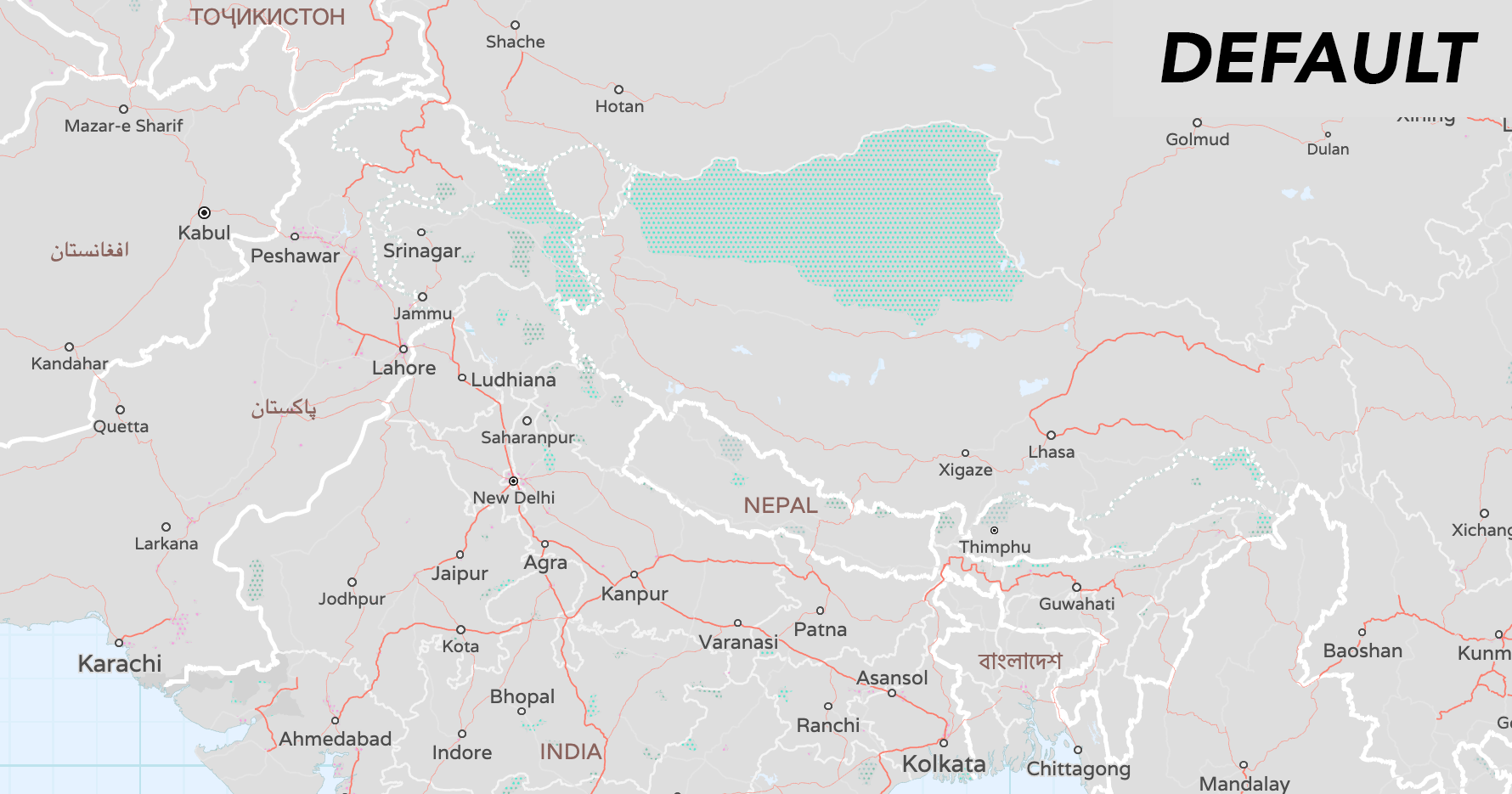
Above: Showing different boundary points-of-view for China, India, Pakistan, paired with label localization.
Show me the disputed OpenStreetMap data
An overview of where I edited (and where I haven’t edited yet) is summarized below. I used Natural Earth (which I am the primary author, and v5.0.0-pre3) as a starting point. I encourage other OpenStreetMap editors to help refine the data according to further research and discussion. Next Nextzen planet update will likely be in December 2019 ;)
I used a combination of Overpass-Turbo select boundary features and JOSM to do the editing. My commits (under user @nvk) have the #disputed_by_claimed_by tag in comment messages.
Example workflow:
- Select data in Overpass-Turbo
- Zoom to an area of interest (see list below)
- Set query, like this to gather up all country, region, and disputed ways:
[out:json][timeout:250]; // gather results ( // query part for: “admin_level=2” way["admin_level"="2"]({{bbox}}); way["admin_level"="4"]({{bbox}}); way["boundary"="disputed"]({{bbox}}); way["boundary"="claim"]({{bbox}}); way["disputed"="yes"]({{bbox}}); relation["claimed_by"]({{bbox}}); relation["disputed_by"]({{bbox}}); relation["recognized_by"]({{bbox}}); ); // print results out body; >; out skel qt; - “Run” to see results, often saying “I’m okay with lots of data”
- Export to “download” as raw OSM data
- Edit data in JOSM
- Use a 2 button mouse, it’s easier than a trackpad
- Load the OSM export file into JOSM
- Add/modify/delete tags on ways:
disputed=yeswhich is generally supported by many renderers as dashed line.disputed_by=AA;BB;CCto lists disputant viewpoints for the way, likeMA;PS;SA. This turns “off” the line for that country’s viewpoint.admin_level:AA=4;6rare! only if the claiming country views the de-facto country boundary instead as a region or county line
- Add/modify/delete way’s membership in relations
- Ensure relation is of
type=boundary, or add new relation of that type - Give the relation a
name=*value likeExtent of Western Sahara claim with Morocco
- Ensure relation is of
- Ensure relation has the right tags
boundary=disputedorboundary=claimas appropriateclaimed_by=DD;EE;FFto list which ISO country codes claim this frontier limit (but does not control it), likeEHdisputed_by=GG;HH;IIlists disputant viewpoints for the way, likeMA;PS;SArecognized_by=XX;YY;ZZto indicate which ISO country codes, even though they don’t claim the territory, recognize the claim and should see it in their viewpoint as a country/region/county, likeDZ.
- Save, adding commit message and tag
#disputed_by_claimed_by.
- Verify changes on OSM.org to ensure there aren’t default display regressions (say at zoom 16)
- Verify changes in vector tile build to verify point-of-view tags
- Repeat until for each disputed area until it’s fixed up
Completed disputed territory work list
Links go to Bubble Wrap with dispute in view. Use the “interactive” mode in the panel in the top right to then mouse over features (say at zoom 16) to “Edit in iD” to perform spot fixes.
- Disputed name – (note) - ID concordance to Natural Earth
- Arunachal Pradesh (South Tibet) – (Admin. by India; Claimed by China) - B00
- Bara Hotii Valleys – (Admin. by India; Claimed by China) - B02
- Crimea – (Admin. by Russia; Claimed by Ukraine) - B89
- Isla del Perejil – (Admin. by Spain; Claimed by Morocco) - B62
- Islas Chafarinas – (Admin. by Spain; Claimed by Morocco) - B65
- Jammu and Kashmir: Aksai Chin – (Admin. by China; Claimed by India) - B07
- Jammu and Kashmir: Azad Kashmir (Azad Jammu and Kashmir) – (Admin. by Pakistan; Claimed by India) - B09
- Jammu and Kashmir: Demchok – (Admin. by India; Claimed by China) - B03
- Jammu and Kashmir: Jammu and Kashmir – (Admin. by India; Claimed by Pakistan) - B05
- Jammu and Kashmir: Northern Areas (Gilgit–Baltistan) – (Admin. by Pakistan; Claimed by India) - B08
- Jammu and Kashmir: Shaksam Valley – (Admin. by China; Ceded to China by Pakistan; Claimed by India) - B06
- Jammu and Kashmir: Siachen Glacierr – (Claimed by Pakistan and India) - B45
- Penon de Alhucemas – (Admin. by Spain; Claimed by Morocco) - B64
- Samdu Valleys – (Admin. by India; Claimed by China) - B04
- Tirpani Valleys – (Admin. by India; Claimed by China) - B01
- W. Sahara – (Admin. by Morocco; Claimed by Western Sahara) - B19
- W. Sahara – (Self admin.; Claimed by Morocco) - B28
Partially completed disputed territory work list (land, major)
- Disputed name – (note) - ID concordance to Natural Earth
- Bhutan (Chumbi salient) – (Admin. by Bhutan; Claimed by China) - B76
- Bhutan (northwest valleys) – (Admin. by Bhutan; Claimed by China) - B75
- Ceuta – (n/a) - B60
- Ilemi Triange – (n/a) - B74
- Ilemi Triangle – (Admin. by Kenya; Claimed by Sudan) - B17
- Kuril Is. – (Admin. by Russia; Claimed by Japan) - B29
- Melilla – (n/a) - B61
- Near Om Parvat – (Admin. by India; Claimed by Nepal) - B88
- Peñón de Vélez de la Gomera – (Admin. by Spain; Claimed by Morocco) - B63
Not completed disputed territory work list (land, high priority)
- Disputed name – (note) - ID concordance to Natural Earth
- Abyei – (Admin. by Sudan; Claimed by South Sudan) - B13
- Cyprus U.N. Buffer Zone – (n/a) - B43
- Golan Heights: Golan Heights – (Admin. By Israel; Claimed by Syria) - B16
- Golan Heights: Shebaa Farms – (Admin. By Israel; Claimed by Lebanon) - B58
- Gaza – (n/a) - B53
- N. Cyprus – (Self admin.; Claimed by Cyprus) - B20
- Somaliland – (Self admin.; Claimed by Somalia) - B30
- South Ossetia – (Self admin.; Claimed by Georgia) - B37
- UNDOF Zone – (UN Patrolled Zone in Syria) - B49
- West Bank – (n/a) - B54 (Zone A, B, C also need tags)
Not completed disputed territory work list (land, lower priority)
- Disputed name – (note) - ID concordance to Natural Earth
- Abkhazia – (Self admin.; Claimed by Georgia) - B35
- Courantyne Headwaters – (Admin. by Guyana; Claimed by Suriname) - B15
- Belize – (n/a) - B51
- Donbass – (Self admin.; Claimed by Ukraine) - B90
- Gibraltar – (Admin. By U.K.; Claimed by Spain) - B55
- Guantanamo Bay USNB – (Leased to U.S.A. by Cuba; Claimed by Cuba) - B50
- Korean Demilitarized Zone (north) – (Since 1953 a 2 km buffer north of the military demarcation line, patrolled by North Korea) - B11
- Korean Demilitarized Zone (south) – (Since 1953 a 2 km buffer south of the military demarcation line, patrolled by South Korea) - B10
- Lawa Headwaters – (Admin. by France; Claimed by Suriname) - B14
- Nagorno-Karabakh – (Self admin.; Claimed by Azer.) - B38
- Olivenza – (Admin. by Spain; Claimed by Portugal) - B67
- Transnistria – (Self admin.; Claimed by Moldova) - B36
- West of Essequibo River – (Admin. by Guyana; Claimed by Venezuela) - B56
Not completed disputed territory work list (water)
- Disputed name – (note) - ID concordance to Natural Earth
- Abu Musa I. – (Admin. by Iran; Claimed by UAE) - B73
- Bajo Nuevo Bank (Petrel Is.) – (Claimed by Columbia, Jamaica, Nicaragua and the United States) - B41
- Bassas da India – (Admin. by France; Claimed by Madagascar) - B27
- Bird Island – (Admin. by Venezuela; Claimed by multiple) - B48
- Br. Indian Ocean Ter. – (Admin. by U.K.; Claimed by Mauritius and Seychelles) - B69
- Diego Garcia NSF – (Leased to U.S.A by U.K.; Claimed by Mauritius and Seychelles) - B44
- Dokdo (Takeshima, Liancort Rocks) – (Admin. by South Korea; Claimed by Japan) - B39
- Europa I. – (Admin. by France; Claimed by Madagascar) - B26
- Falkland Is. (Islas Malvinas) – (Admin. by U.K.; Claimed by Argentina) - B12
- Glorioso Is. – (Admin. by France; Claimed by Madagascar) - B24
- Hans I. – (Admin. by Denmark; Claimed by Canada) - B21
- Juan De Nova I. – (Admin. by France; Claimed by Madagascar) - B23
- Matthew and Hunter Is. – (Admin. by New Caledonia for France; Claimed by Vanuatu) - B66 (Not sure these are in OSM)
- Mayotte – (Admin. by France; Claimed by Comoros) - B22
- Mbane I. – (Admin by Gabon; Claimed by Equatorial Guinea) - B52
- Navassa I. – (Admin. by U.S.A.; Claimed by Haiti) - B34
- Paracel Is. – (Admin. by China; Claimed by Vietnam and Taiwan) - B47
- Pinnacle Is. (Senkaku Is., Diaoyu Is., Diaoyutai Is.) – (Admin. by Japan; Claimed by China and Taiwan) - B18
- Rockall I. – (Admin by U.K.; Claimed by Ireland, Denmark, and Iceland) - B31 (Not sure this is in OSM)
- S. Georgia – (Admin. by U.K.; Claimed by Argentina) - B32
- S. Sandwich Is. – (Admin. by U.K.; Claimed by Argentina) - B33
- Sapodilla Cayes – (Admin. by Belize; Claimed by Honduras and Guatemala) - B80
- Scarborough Reef – (n/a) - B70
- Serranilla Bank – (Claimed by Columbia, Honduras, Nicaragua, and the United States) - B42
- Spratly Is. – (Claimed by China, Taiwan, Malaysia, the Philippines, Vietnam, and Brunei) - B46
- Swains Island (Olohega) – (Admin. by American Samoa for U.S.A.; Claimed by Tokelau) - B71
- Tiran and Sanafir Is. – (Admin. by Egypt; Claimed by Saudi Arabia) - B68
- Tromelin I. – (Admin. by France; Claimed by Mauritius and the Seychelles) - B25
- Wake Atoll – (Admin. by U.S.A.; Claimed by Marshall Islands) - B59
Discussion
Comment from Carnildo on 14 August 2019 at 23:15
I don’t think Guantanamo Bay Naval Base is a border dispute of the sort you’re trying to map here: the USA and Cuba both agree that the land is part of Cuba. The dispute is that the USA says they’re leasing land for a naval base from Cuba; Cuba says the lease was agreed to under duress and is void.
Comment from naveenpf on 15 August 2019 at 01:53
this is very interesting .. Added the link here osm.wiki/WikiProject_India/Boundaries/National_borders
Comment from pnorman on 19 August 2019 at 21:29
It’d be good to see this work on osm.org via submitting bubble wrap to be a featured tile layer. Are you interested in submitting it?
Comment from nvk on 20 August 2019 at 05:19
@Carnildo: While there is a military feature in OSM for Guantanamo Bay Naval Base (osm.org/way/39037988), I include it in the list above because there is no admin boundary or even barrier tagged in OSM between Cuba and United States administration there – and there is a real world, on the ground difference between being on either side of that boundary in terms of the money in circulation, how mail is distributed, the civil administration, and military administration plays out. The same can be said of Diego Garcia NSF and other places, even the Baikonur Cosmodrome. The countries party to these complicated situations aka “claims” generally agree on the ultimate sovereignty, but OSM doesn’t currently reflect the day-to-day administration of these places. Think also of Hong Kong before the lease expired there, and the complicated “1 country, 2 systems” legal arrangement.
Comment from nvk on 20 August 2019 at 05:20
@pnorman: Sure, that sounds like a good idea to see this on OSM.org :)
Comment from pangoSE on 23 August 2019 at 16:45
Hi nvk. Instead of downloading via the overpass turbo website I suggest you download directly from the (by default hidden) overpass turbo tab in JOSM.
See https://josm.openstreetmap.de/wiki/Help/Action/Download for details (you have to enable “expert mode” to succeed.)
Comment from nvk on 23 August 2019 at 17:34
@pangoSE: Thanks for the tip!
Comment from AngocA on 3 April 2026 at 18:27
Very interesting article. Based on the text, I improved a disputed maritime area between Colombia and Venezuela: osm.org/relation/2040697
Comment from pnorman on 3 April 2026 at 19:36
osm.org/relation/20406978 is the relation you created. A big difference from what nvk documented is you added admin_level=2 to the relation, not just the underlying ways. The wikidata ID is also wrong. You’ve given that relation the wikidata ID of the entire border, not one associated with the disputed area.
I’m not sure this is right. That relation is claiming the existence of a country called “Diferendo Golfo de Venezuela” that isn’t recognized by everyone. That’s not what’s happening as far as I can see. Everyone involved agrees there are only two countries, they just disagree on their extents.
Looking at Columbia and Venezuela I’m not sure if those relations are right. Those relations should be following the on-the-ground rule. I was expecting the on-the-ground situation to be one of - the area is under Columbian control and should be part of the Columbia relation, - the area is under Venezuelan control and should be part of the Venezuela relation, or - the line of control is somewhere between (e.g. the old border as drawn in OSM) and the relations should go up to that line.
I’m not familiar enough with the disputed area to say which is right, or if it’s some more complex situation.