andrewsh's Comments
| Post | When | Comment |
|---|---|---|
| Updated contributor stats - the end of maps.me |
Harry, but they killed it themselves, when mail.ru sold it to some crypto scammers. I’d say today Organic Maps are better than maps.me, since it is actually developed, and by the original team. |
|
| 2021-04-20 19:00 OSM Duma: OsmAnd névjegykártya, landing page, találkozóink ütemezése | Voltam a Velikie Luki-ban találkozón, nagyon jó volt. Orosz nagymamák azt hitték, hogy kémek vagyunk 😀 |
|
| Strange GUI issues with JOSM and Ubuntu/Debian | Thanks. I was seeing this and a couple of other issues recently, I switched from GTK+ theme to Metal, but not all of them disappeared. |
|
| ВАТ | @BushmanK прав. И, кстати, имхо «схемотехника» вполне ок. |
|
| Ищу мапперов | Игорь, меня берут сомнения в легальности рисования по кадастровой карте и лицензионной чистоте полученных данных. Будь это кадастровая карта Чехии или Словакии, было бы ясно — public domain. В Беларуси с этим сложнее… |
|
| Harry Wood admin abuse. Do we need him as admin at wiki??? | @d1g, I honestly believe it’d be better for everyone if you just left. |
|
| Gdzie.bl.ee - github | Great, thanks! |
|
| Mapz OSM dla innzch pa}stwa | A co właśnie chcesz ściągnąc? Jak korzystasz OsmAnda, tak za pomocą menu to możesz zrobić. Inaczej OSM dumpy znajdziesz tutaj: http://download.geofabrik.de/europe.html |
|
| Свежий JOSM не любит шестую яву | Max, в убунте используется стандартный механизм, как и в дебиане. Это жосм его обходит. |
|
| Android OSM apps | Try OsmAnd. It’s great. |
|
| FIX THE MAP | I’ve noticed this page doesn’t detect if the user’s already logged in: Start Mapping button still points to osm.org/user/new, not to osm.org/edit. That probably needs fixing. |
|
| 4 | Вроде бы можно картинки напрямую в JOSM открывать, без промежуточного GPX. |
|
| I am new to this digital mapping tool... | Yes. You can install an application to use the OpenStreetMap data in off-line mode. The best application for Android to date that I know that works worldwide is OsmAnd, which is a free and open source application, but it comes also with a paid version to support the author. For the United Kingdom, however, there’s a good application called CycleStreets — but as far as I know they don’t provide non-UK data dumps for you to use in Denmark. |
|
| SME.sk displays presidential election results on OpenStreetMap | Try choosing different candidates from the combo box near the next map (not OSM, presumably, but the official cadastre rather, I think). It distorts the map in fish eye style and display nice animation of a histogram being sorted :) |
|
| SME.sk displays presidential election results on OpenStreetMap | The label over the map translates as ‘The size of a bubble shows the number of voters [in the town], and the colour corresponds to the winner’. A little bit strange, yes. |
|
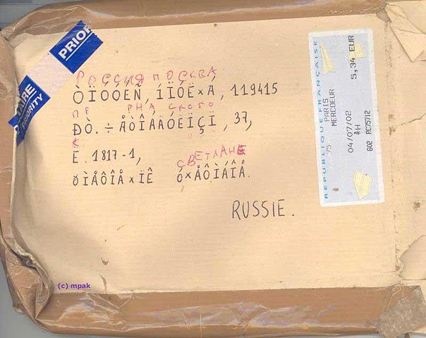
| Кракозябры |
|
|
| My new website | If you add aliases to your webserver config, I can add a CNAME record pointing to your domain. If you want, of course :) |
|
| My new website | Hi, This is precisely what I wanted to do few years ago (but never managed to finish), and I have cafemap.info and cafémap.info domains for that. Do you want to use them? :) |
|
| Test | Test passed! |
|
| Недостаток подложек | Xinfeng, дело не в юристах. Дело в том, для чего затевался проект. А проект затевался для того, чтобы получить свободную карту. Несвободных «нарисуек» и так хватает, а свободных вот нет. |
 :)
:)