.jpg)
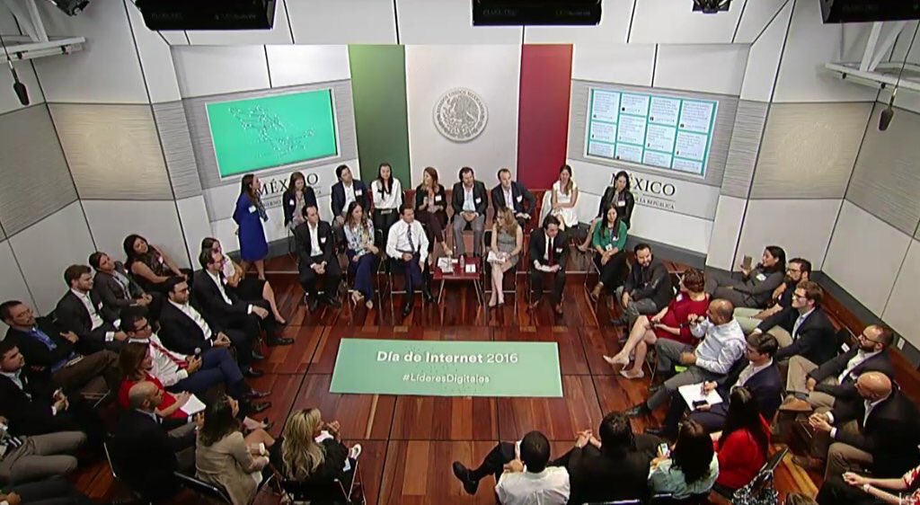
HOTOSM recognition by the President of Mexico in Internet Day 2016
Posted by Mapanauta on 7 June 2016 in English.**Versión en Español: Reconocimiento a HOTOSM por el Presidente de México en el Día del Internet 2016 — Short Link: http://bit.ly/hotosm_mx_es **
On the Internet Day, May 17 2016 the President of Mexico Enrique Peña Nieto invited fifty citizens who called Digital Leaders (#LideresDigitales) to have a dialogue on the future of technology and Internet in Mexico, I had the opportunity of being among these group of citizens. The President talked about various related topics but especially appreciated the efforts of humanitarian mapping conducted by Humanitarian OpenStreetMap in Hurricane Patricia.

Why the President of México thanked the efforts from HOTSOM in Hurricane Patricia? Here you will find some details so you know what was done.
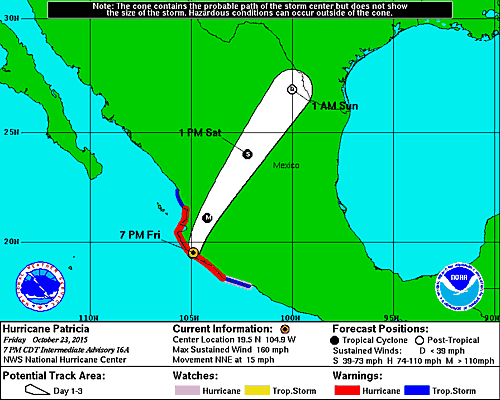
On October 23, 2015 Hurricane Patricia threatened to touch the states of Colima, Nayarit and Jalisco with winds up to 325 km/h, authorities of Mexico mentioned “It is very likely that this hurricane is the strongest ever in the Pacific side of our country, since it has records “
Contributors of OpenStreetMap and HOTOSM like Rodolfo Wilhelmy, Humberto Yances, Rafael Avila, Robert Banick, Andres Ortiz, and many others (sorry for not mentioning everyone) in addition to an army of over 500 mappers of Mexico and the world joined efforts to support this area of the Mexican Pacific with data that could be used for the benefit of the population that could be affected. Fortunately, the hurricane lost strength by touching the coast of Mexico causing minimal damage compared to what was expected.
Quick stats:
More than 500 contributors mapped 9,000 kms of roads (5.6k miles of road) + 72,000 buildings in 72hrs It was processed 29,608 km^2 pre-event DigitalGlobe imagery to improved coverage over priority areas. It was analyzed INEGI road data to identify missing roads and road names in OSM data. Mexico Open Data was confirmed by authorities to be used in OpenStreetMap. All these was possible thanks to the great work HOT members, companies supporting OSM project and the local community in Mexico and the World

The event took place in Los Pinos (The equivalence of the U.S. White House) at the moment the Open Data topic was mentioned, Peña Nieto said he knew someone who had supported the alert for Hurricane Patricia was among the guests so I raised my hand to start the dialogue, the President mentioned “… I just want to thank because it’s an example that illustrates very well what we can achieve and I think that you also use open information.” In my participation I could give my point of view on the need for Mexico not only upload open data to be the first in quantity of released Open Data but emphasize the need of quality Open Data in order to take better decisions based on them. Also I could mention the importance of Open Mapping and collaboration between Governments and Civil Society so more Mexicans are less harmed by disasters (find the 3 min video here).

In Mexico the OpenStreetMap community is not as numerous as in other countries but in the last two years a group of collaborators we have joined together to promote the project and increase the local community through massive workshops in Universities and courses for Government Authorities and Civil Society. Much remains to be mapped but I believe we are on the right track.
Miriam Gonzalez
Discussion
Comment from PlaneMad on 8 June 2016 at 11:59
Amazing, this is a great example of how valuable projects like HOTOSM are for developing nations like India where millions of citizens are vulnerable to disasters like cyclones and flooding. Nice work all!
Comment from Sunfishtommy on 16 June 2016 at 03:00
This is really cool, I map heavily in Mexico, so it is really cool to see our efforts recognized.