
The State of OpenStreetMap in Africa 2023
Posted by Kateregga1 on 17 January 2024 in English. Last updated on 18 January 2024.State of OpenStreetMap in Africa 2023
This article presents a comprehensive overview of the OpenStreetMap (OSM) landscape in Africa as outlined by Geoffrey Kateregga during the State of the Map Africa 2023 conference, held both in Yaoundé, Cameroon, and online. Serving as an update to the previous assessment conducted in 2020, the overview stems from a survey organized by OpenStreetMap Africa, a collaborative network of OSM Communities across the continent. The conference provided insights into the current state, challenges, and successes of OSM communities in Africa, encompassing responses from 50 out of the 54 countries, offering a nuanced understanding of the evolving OSM landscape on the continent.
Survey Methodology and Participants:
The survey, conducted by OSM Africa, engaged members from diverse communities, organizations, and individual contributors across the continent. With responses from 50 countries, the survey covered a substantial portion of Africa, there were no responses to the survey from Central African Republic, Equatorial Guinea, Eritrea, Guinea-Bissau, Mauritius, São Tomé and Príncipe, Seychelles.
OpenStreetMap Africa Data Coverage 2023
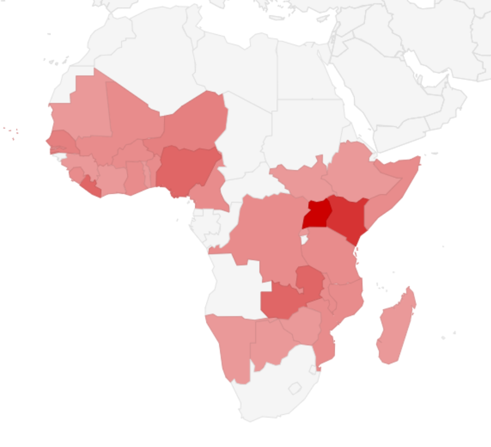
The OpenStreetMap (OSM) Africa Data Coverage for 2023 provides a comprehensive overview of the mapping status across the continent. With a total population of 1.5 billion and a populated area of 5.2 million km², the data reveals both significant achievements and ongoing challenges in OSM mapping efforts. While a substantial portion of the population has mapped buildings (49.69% of the total population) and roads (86.67% of the total population), there are still areas with room for improvement. Notably, 13.6 million people live in areas with unmapped OSM buildings (9.07% of the total population), and 3.2 million reside in regions with unmapped OSM roads (2.13% of the total population). The country-specific analysis sheds light on variations in mapping coverage, with some countries facing substantial challenges in achieving comprehensive data coverage. Nigeria and Ethiopia, despite their large populations, exhibit notable proportions of unmapped objects, buildings, and roads, indicating areas where focused mapping efforts are needed. In contrast, certain countries showcase impressive mapping achievements. The data underscores the importance of targeted interventions and strategies to enhance OSM data coverage, ensuring a more complete and accurate representation of geographical information across Africa.
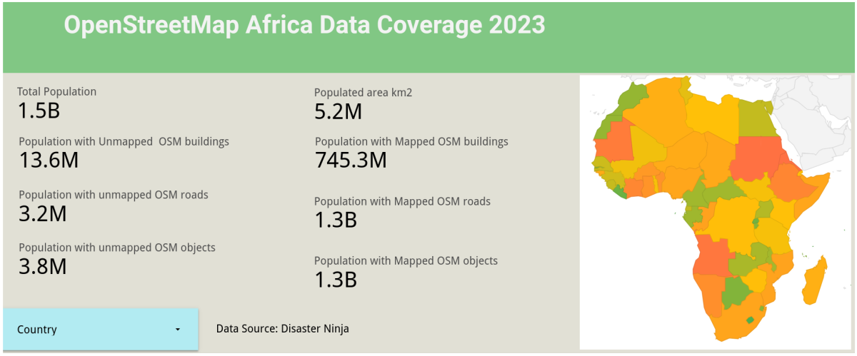 Interact with the dashboard to see country-specific statistics.
Involvement in OSM
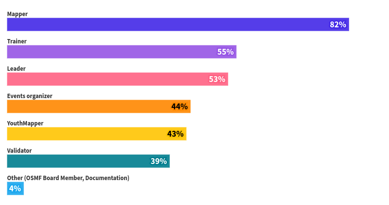
The analysis of responses regarding involvement in the OpenStreetMap (OSM) Community in Africa indicates a thriving and diverse ecosystem. Mapping emerges as the primary activity, with a substantial 82.46% of respondents identifying themselves as mappers, showcasing a strong commitment to contributing geographical data. Beyond mapping, significant percentages of individuals engage in roles such as trainers (55.26%), leaders (52.63%), and events organizers (43.86%), illustrating a multifaceted engagement within the community. YouthMapper affiliation at 42.98% highlights active involvement from young participants, while validators (39.47%) play a crucial role in ensuring data accuracy. The presence of ‘Other’ categories (4.39%) signifies additional, diverse contributions within the community, showcasing a well-rounded and active OSM community in Africa.
Types of Communities and Organizations
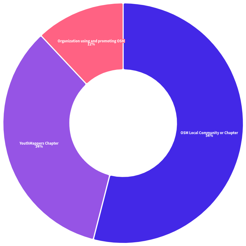
The analysis of the type of communities or organizations within the OpenStreetMap (OSM) ecosystem in Africa reveals several key observations. OSM Local Communities or Chapters comprise the largest segment at 53.51%, indicating the significant presence of localized OSM groups engaged in mapping activities, events, and collaborations within specific regions. YouthMappers Chapters follow closely, constituting 34.21% of the responses, indicating a substantial involvement of young individuals and educational institutions dedicated to OSM activities. Organizations utilizing and promoting OSM represent 11.4% of respondents, highlighting external entities leveraging OSM data or advocating its use for various purposes. Interestingly, a very marginal 0.88% of respondents indicated not being part of any OSM Community, suggesting a high level of involvement or affiliation within OSM-related groups or chapters across the surveyed population in Africa.
Current Status of OSM Communities in Africa
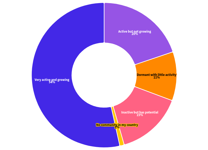
The analysis of responses regarding the current state of OpenStreetMap (OSM) communities in Africa provides insights into their levels of activity and growth. A majority of respondents, accounting for 53.51%, perceive their OSM community as “very active and growing.” This indicates a robust and expanding engagement within these communities, likely characterized by consistent participation, ongoing projects, and an increasing number of contributors. Additionally, 20.18% of respondents consider their community as “active but not growing,” suggesting ongoing involvement but possibly facing challenges or limitations inhibiting substantial expansion. A smaller yet significant portion, 14.91%, perceives their community as “inactive but having potential,” indicating the existence of opportunities for revitalization or growth. Furthermore, 10.53% describe their community as “dormant with little activity,” indicating reduced engagement or minimal ongoing efforts. Lastly, a very marginal 0.88% of respondents indicated the absence of an OSM community in their country, signifying a lack of organized OSM-related activities or groups in their region.
Reasons for the Current Status of OSM communities in African Countries
-
Active and Growing Communities: Several communities highlighted their vibrant status, actively engaging in regular mapathons, training sessions, and awareness campaigns. This activity contributes to growing memberships and partnerships with government and non-governmental organizations, facilitating mapping projects across regions.
-
Challenges in Growth: Lack of resources and funding emerged as a significant hurdle for various communities, hindering their potential growth despite motivated members and ongoing initiatives. In some cases, limited access to mapping equipment, internet, and physical spaces for meetings or training sessions affected community engagement and project execution.
-
Leadership and Organizational Challenges: Instances of inactive periods or reduced activity were attributed to leadership challenges, either due to changes in leadership causing disruptions or issues related to coordinating meetings and maintaining consistent engagement among members. Some communities expressed the need for a more structured leadership team to ensure fluid operations.
-
Youth Engagement and Training: Numerous YouthMappers chapters reported increased activities and partnerships, emphasizing the importance of youth engagement, education, and skill development in the growth of their communities. They noted initiatives like training programs and collaboration with universities.
-
Regional and Country-Specific Challenges: Certain regions faced unique obstacles such as inadequate mapping tools, electricity shortages, limited internet access, and high costs, impacting their mapping activities and community growth.
-
Community Resilience: Despite challenges, many communities showcased resilience, dedication, and efforts to collaborate with international organizations, secure grants, or work independently on mapping projects to foster community growth and sustain active participation.
-
Newly Established Communities: Newly established chapters expressed optimism about their potential for growth and involvement in various mapping projects once they overcome initial challenges of resources, partnerships, and awareness.
-
Collaborations and Partnerships: Strong collaborations with governmental agencies, humanitarian organizations, and educational institutions were highlighted as crucial factors contributing to the growth and dynamism of certain OSM communities.
In summary, the challenges faced by these OSM communities in Africa revolve around resource limitations, leadership dynamics, technological constraints, and regional-specific issues. Despite these challenges, there is evident enthusiasm, commitment, and a drive to overcome obstacles and actively contribute to mapping projects and community development.
Outstanding successes of OSM Communities in African Countries
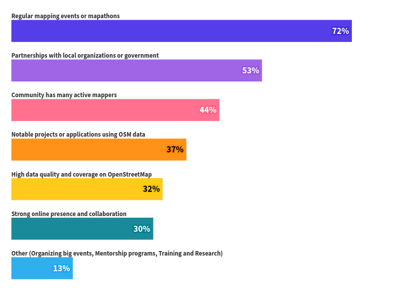
A predominant achievement lies in the consistent hosting of mapping events or mapathons (71.93%), showcasing these communities’ active participation in data collection and updates. Equally significant are the partnerships formed with local organizations or government bodies (52.63%), indicating the community’s integration into broader initiatives. The presence of numerous active mappers (43.86%) underscores a committed and engaged group continually contributing to map data. Noteworthy projects and applications utilizing OSM data (36.84%) demonstrate the practical implementation and value of their efforts, while high data quality and coverage (32.46%) signify their commitment to accurate and comprehensive geographical information. Additionally, a strong online presence and collaborations (29.82%) foster visibility, knowledge exchange, and partnerships within and beyond the OSM network. Other unique achievements, not explicitly outlined, further enrich the diverse successes across these communities (13.16%).
Community Led Iniatives and Projects
The responses from various OpenStreetMap (OSM) communities highlight a diverse range of community-led initiatives, projects, and campaigns. While some communities primarily focus on mapping activities such as roads, transportation, and land use, others engage in specific projects with notable impacts.
For instance, the OSM community in Ethiopia has undertaken projects like mapping the OMO Zone for food security, identifying drought-prone areas in Borena, and mapping flood-prone areas for El Niño preparation. Similarly, OSM Ethiopia collaborated with the Food and Agriculture Organisation (FAO) to map flood-prone areas in anticipation of El Niño rains.
In Burkina Faso, the OSM community has been involved in projects like mapping healthcare districts, schools, and transportation. In Chad, there are initiatives related to open data and digital commons creation. The YouthMappers in Nigeria engage in projects like Map Nigeria Mapathon, Open Mapping for Heat and Health, and Mapping for Resilience.
In Djibouti, a project focused on mapping refugee camps is underway. The YouthMappers at the University of Liberia have participated in projects related to tracking floods, COVID-19 response, and open cities mapping in Monrovia.
Noteworthy projects by other OSM communities include mapping flood-prone areas in Liberia, mapping schools and healthcare facilities in Rwanda, and initiatives like Mia Tou Togo for raising awareness on the importance of geographical data for planning in Togo municipalities. The OSM community in Zambia has recently organized a mapping meetup to introduce new members to the OSM community.
These projects collectively demonstrate the impactful contributions of OSM communities to various sectors, including disaster preparedness, public health, food security, and community development.
OSM Africa Communities Challenges
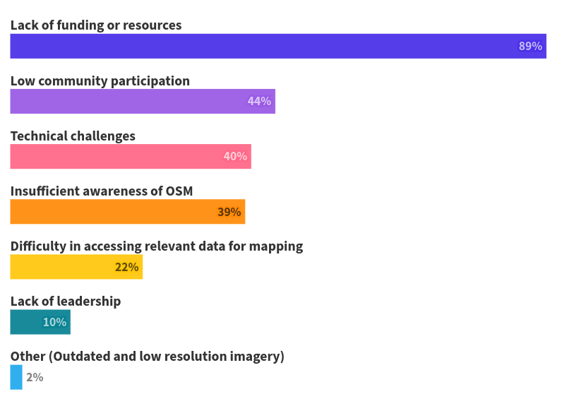
The survey findings highlight several pressing challenges encountered by the OpenStreetMap (OSM) community. The foremost concern, articulated by 88.6% of respondents, is the “Lack of funding or resources,” hindering the execution of community initiatives and mapping projects. Additionally, 43.86% noted “Low community participation,” indicating difficulties in engaging and maintaining an active user base within the OSM community. Technical hurdles were raised by 40.35% as “Technical challenges,” which might encompass issues with tools, data accuracy, or limitations within the mapping platform. A significant proportion (39.47%) identified “Insufficient awareness of OSM” among potential contributors or beneficiaries, potentially hampering community expansion. Furthermore, 21.93% highlighted “Difficulty in accessing relevant data for mapping,” which can limit the accuracy and depth of mapped information. A smaller percentage (9.65%) expressed concern over the “Lack of leadership,” impacting the direction and guidance needed for community-driven mapping projects. Moreover, 1.75% noted the low resolution and outdated aerial imagery,” as a fundamental issue faced by numerous OSM communities, indicating the necessity for high-quality reference imagery for accurate mapping endeavors. Addressing these multifaceted challenges would likely entail strategies such as securing sustainable funding, enhancing community outreach efforts, providing technical support, fostering leadership roles, and ensuring access to reliable mapping data, including high-quality reference imagery, crucial for mapping accuracy and completeness.
OSM Africa Communities Communication Channels
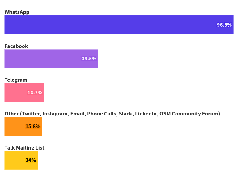
The survey results outline the primary communication channels employed by the OpenStreetMap (OSM) community, with 96.49% utilizing WhatsApp groups as the most prevalent means of communication. Following WhatsApp, Facebook groups were also notably utilized, though to a lesser extent, by 39.47% of respondents. Telegram groups were employed by 16.67% of the community, indicating a moderate level of usage compared to the more dominant platforms. Furthermore, the “Other” category, encompassing various unspecified communication channels, was reported by 15.79% of respondents.
The additional communication channels used by the community, albeit to a lesser degree, were Twitter (4.39%), Instagram (1.75%), and traditional methods such as mail and phone calls, each accounting for less than 1% of usage. Some respondents mentioned unconventional channel combinations like Twitter and LinkedIn, or mentions of specific platforms like Slack, LinkedIn, and Zoom, each representing a negligible percentage of usage (less than 1%).
Overall, while WhatsApp emerges as the primary communication tool, there’s a diverse array of secondary channels used by the OSM community, suggesting a need for multi-platform engagement strategies to cater to various preferences and ensure comprehensive communication within the community.
OSM Africa Communities Membership Structures
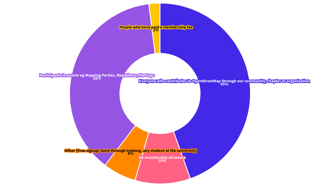
The results indicate diverse perspectives on membership within the African OpenStreetMap (OSM) communities. The most prominent definition, endorsed by 44.74% of respondents, highlights membership as inclusive of anyone contributing to OpenStreetMap through their community, chapter, or organization. Additionally, 37.72% of respondents define membership as individuals actively participating in community events such as Mapping Parties, Mapathons, Meetups, etc.
A smaller portion, 9.65%, indicated that their community lacks a defined membership structure. Moreover, 6.14% of respondents selected the “Other” category, which included various explanations such as participation in training sessions, an open community with no membership fees but requires active engagement, accessibility for anyone interested to contribute to mapping, involvement of individuals who underwent specific OSM training or were affiliated with certain academic institutions (e.g., University of Dodoma, GIS Program students).
These diverse definitions reflect the fluidity and inclusivity of membership within local OSM communities, ranging from formal contributions to more open and participatory criteria, emphasizing engagement, training, or affiliation with specific educational institutions.
OSM Africa Communities by Gender
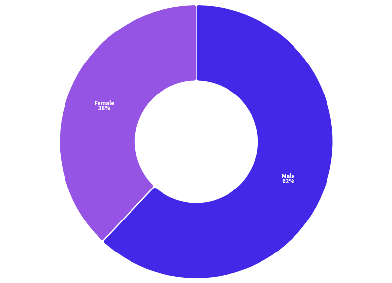
In terms of percentages, males constitute around 62%, whereas females account for approximately 38% of the total membership across these communities. This discrepancy suggests gender-related challenges or barriers that could exist within these communities, influencing the lower representation of females. Increasing female participation could be an area of focus to foster greater diversity and inclusivity within these OSM groups.
Leadership and Governance Structures
The analysis of the leadership or governance structures within various OSM communities reveals diverse models of organizational frameworks. Among the respondents who provided descriptions:
- Approximately 73.68% (84 respondents) indicated that their community does have a leadership or governance structure, while around 26.32% (30 respondents) mentioned not having such a structure.
- The existing structures vary widely, from formal NGO structures to elected committees or boards overseeing various positions such as president, vice president, secretaries, treasurers, advisors, and technical roles.
- Some groups mentioned a core group or a few individuals coordinating community activities, while others outlined specific positions within their leadership structures, including communications officers, coordinators, ambassadors, and executive committees.
- A notable aspect is the involvement of female leadership positions in some communities, highlighting diversity and inclusion efforts within these organizations.
- A few respondents mentioned the election or selection process for leadership positions, some with terms of service and specified durations.
- Additionally, there were references to ongoing efforts for official registrations as NGOs and the establishment of legal governance frameworks.
Overall, the responses illustrate a range of leadership structures tailored to the needs and contexts of each OSM community, emphasizing the presence of formal, elected, or appointed leadership bodies guiding and coordinating activities within these groups.
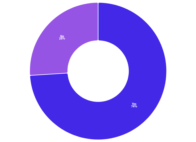
Awareness about other organizations, communities or companies that are using or promoting OSM
The survey results reveal a substantial awareness among respondents regarding the utilization or advocacy of OpenStreetMap (OSM) by companies, organizations, and communities in their respective countries. 56% indicated awareness of other entities using or promoting OSM, while 44% were not aware of any other organizations or communities. The list provided by respondents showcases a diverse range of entities, including governmental bodies, NGOs, humanitarian agencies like Médecins Sans Frontières (MSF), International Organization for Migration (IOM), and the Red Cross, educational institutions with dedicated YouthMappers chapters, and various UN-affiliated organizations across different countries. Moreover, it highlights specific projects, local mapping groups, and companies actively using OSM for diverse purposes such as geospatial technology, disaster risk mapping, health services, addressing projects, and more. These results emphasize the widespread adoption and application of OSM across different sectors and regions worldwide.
Meeting Frequency
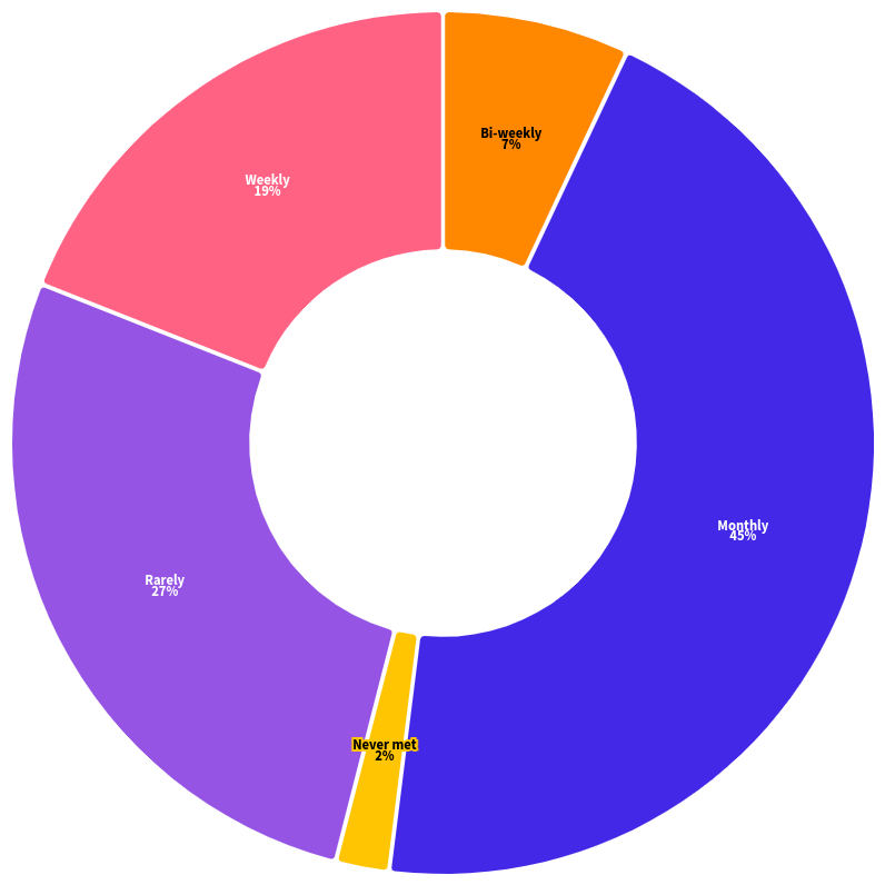
The results indicate the following - Monthly events are the most frequent, comprising 45% of the responses. - Rarely organized events accounted for 27% of the answers. - Weekly meetups constituted 19% of the responses. - Bi-weekly events were less common, making up 7% of the replies. - Only a small percentage, 2%, reported that the community has never met for events or meetups.
This varied distribution highlights the range of engagement within the OpenStreetMap community. While a significant portion convenes monthly, a notable number meets less frequently, emphasizing the differing preferences or possibilities for participation among community members. Despite these differences, it underscores a commitment to fostering collaboration and knowledge-sharing within the OSM network, albeit at various intervals and levels of engagement.
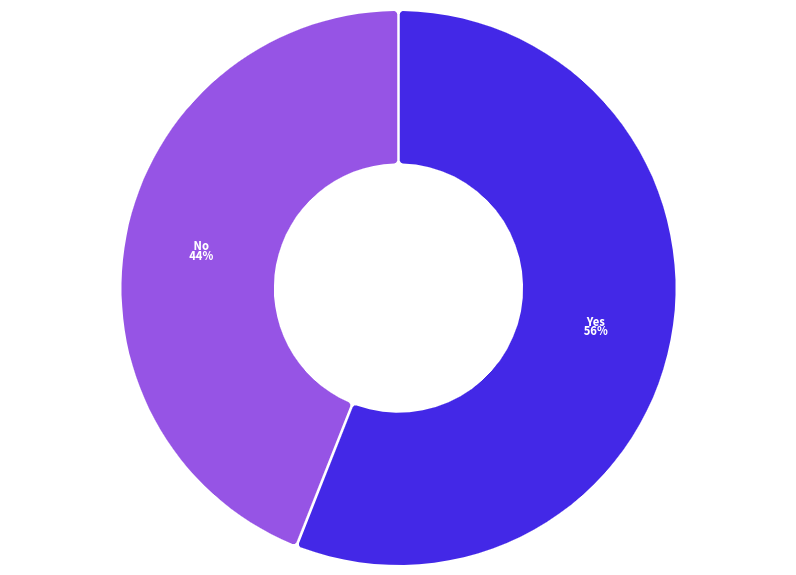
Online Presence
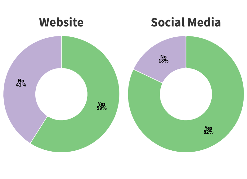
The analysis of the community’s online presence indicates that while a significant portion of respondents, approximately 59%, reported that their OpenStreetMap (OSM) community lacks a dedicated website or blog, 41% confirmed the existence of such online platforms. Additionally, an overwhelming majority of respondents, accounting for 82%, mentioned that their community utilizes social media channels, highlighting a robust online presence in terms of social networking platforms within the OSM community.
These findings suggest a considerable reliance on social media platforms as a primary means of communication and engagement within the OSM community, despite a notable portion not having a specific website or blog dedicated to their group (18%). The prevalence of social media usage demonstrates an active effort to maintain an online presence and facilitate communication and collaboration among community members.
YouthMappers Chapters in Africa
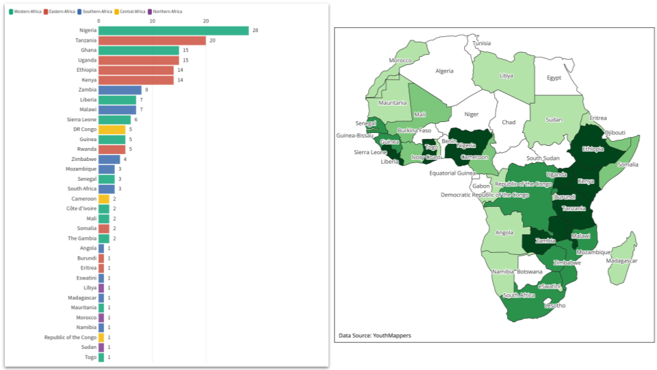 One of the pivotal factors in driving the OSM movement in Africa is YouthMappers, with university students actively engaging in mapping activities that directly address development needs. The presence of 184 (48%) out of 385 global YouthMappers chapters in Africa underscores the organization’s substantial influence on OpenStreetMap initiatives across the continent. YouthMappers is a global community of students, researchers, educators, and scholars with a specific focus on utilizing public geospatial technologies to address development and environmental challenges globally. Their model of fostering OSM growth through universities has proven effective, as students, motivated by a direct incentive to volunteer through mapping, not only contribute to open data but also acquire valuable geospatial skills. Moreover, YouthMappers’ provision of Leadership and Research Fellowships contributes to the development of future leaders within OSM communities, reinforcing the symbiotic relationship between academic institutions and the OSM network. The growth from 105 chapters in 2020 to reflects a positive trend, underlining the impact and potential of engaging university students in geospatial mapping initiatives.
Impact of Humanitarian OpenStreetMap Team’s OpenMapping Hubs in Africa
HOT Country Projects and Community Grants Coverage Since 2020, The Humanitarian OpenStreetMap Team (HOT) has established two regional Open Mapping Hubs in Africa that have made a significant impact in growing OpenStreetMap (OSM) communities in Africa. The Open Mapping Hub — Eastern and Southern Africa actively supports the creation, maintenance, distribution, and use of high-quality open maps in the region. Through its granting program, it collaborates with organizations and communities to enrich OpenStreetMap data and implement innovative map data solutions that improve lives. Notably, ongoing projects in Uganda, Kenya, Zambia, Malawi, Namibia, and Tanzania address various critical issues such as contraceptive access, disaster resilience, local impact governance, climate resilience planning, and community impact microgrants. The Spatial Solutions Accelerator program further empowers self-organized open mapping communities in the region by providing grants and organizational development support. In West and Northern Africa, the Open Mapping Hub has conduceted projects to stimulate leadership, promote social justice in accessing open data, and supported projects targeting crucial areas like rural water access, public health, flooding, and sustainable cities. The team’s efforts have been crucial in addressing local challenges, fostering collaboration, and contributing to a more inclusive and sustainable future through the power of open map data.
Conclusion
In conclusion, the State of OpenStreetMap in Africa, as unveiled during the State of the Map Africa 2023 conference, paints a vivid picture of a thriving and dynamic community deeply committed to mapping the diverse landscapes of the continent. From significant achievements in mapping buildings and roads to active participation in mapathons and impactful projects, the OSM communities in Africa showcase resilience and dedication. While facing challenges such as funding limitations and leadership dynamics, these communities demonstrate a collective enthusiasm to overcome obstacles and actively contribute to various sectors, including disaster preparedness, public health, and community development. The State of OpenStreetMap in Africa not only reflects the current landscape but also sets the stage for collaborative efforts, innovation, and continued growth, underscoring the integral role of OSM in shaping a more comprehensive and accurate representation of geographical information across the continent.
Video: OpenStreetMap Communities and Organizations in Africa
Please share any feedback or ideas on how this work can be improved in the future. Your input is invaluable as we strive to enhance the understanding and representation of OpenStreetMap in Africa.
Discussion
Comment from KAWAMALA on 17 January 2024 at 10:58
This is Fantastic Geoffrey
Comment from Kateregga1 on 17 January 2024 at 13:15
Thank you too Antidius for contributing to the survey!
Comment from KingVik on 17 January 2024 at 22:40
This is really amazing 👏
Comment from pedrito1414 on 18 January 2024 at 13:23
Nice one, OSM Africa :D
Comment from migurski on 21 January 2024 at 04:55
Thank you for sharing, love to see this!
Comment from vicksun on 26 January 2024 at 23:09
Thank you Geoffrey for this report !!!
Comment from Raquel Dezidério Souto on 29 January 2024 at 05:10
A complete outlook of the African OSM communities, congrats! 😀
Comment from Walter Mayeku on 29 January 2024 at 18:53
This is brilliantly done, thank you for sharing