 OpenStreetMap
Users' Diaries
Recent diary entries


呃好吧,我是新來的,可以叫我kiwi,熱愛刷機的kiwi。 先說說我為啥來這好了,我是為了因應「去谷歌化」與「自製BOB包」(好吧我根本就怪人),在網上爬啊爬,並在F-Droid上下載了這個開源地圖。 然後我在我刷了crdroid 8.6的Sony Xperia xz1上安裝了這個軟體,挺讓我驚奇的是,意外的好用,絲滑流暢,甚至在我的低端機上都運行的非常順利。 於是今天我就開始跑點了,我居住的小鎮上有很多無名小店,跑點這個過程讓我感到愉快。 希望各位能多多包涵我這怪人:) My telegram: https://t.me/taro_7421

One thing that usually worries us as OpenStreetMap mappers is having our hard work deleted by someone else, either accidentally or intentionally.
Thankfully, our edits are still in the database.
The delete operation in OpenStreetMap is not really a delete operation. It simply flips the object’s visible flag from true to false, while retaining its entire history.
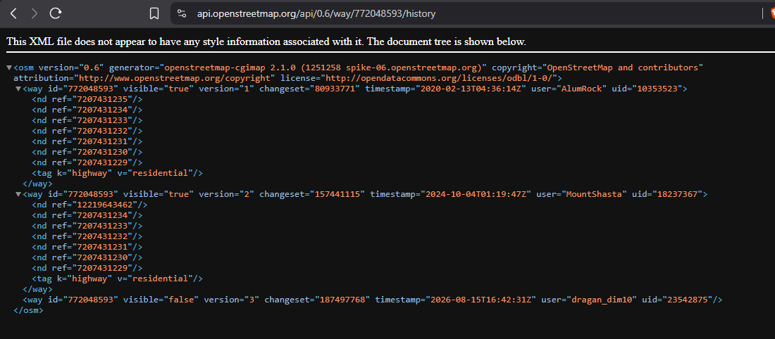
And you can resurrect them using JOSM’s “Undelete Object” feature, as long as you have the OSM object’s ID.

New flock alprs are appearing in neighborhoods near where I go to college. This is scary, do your part.
- ᵈⁱˢᵗᵃⁿᶜᵉᵈ

I’m undergoing the learning path “Open Mapping Essentials” on HOT´s learning centre. In the process I have contributed by mapping local businesses and housing buildings in Managua. I also added a few rural roads in the Esteli area. All my changes are based on local knowledge of the areas. I am looking forward to contributing to the OSM and HOT communities.
Hi guys.
I would like to emphasize the benefit that the micromapping of certain features can contribute to unhoused communities. Of course, there still needs to be more awareness of OSM within these communities, but the data being there is great for the future and making the map more useful.
Tagging if the seats on benches are separated or not allows people to know where they are able to lay down and thus sleep if they don’t have access to other places to sleep. The tag seats:separated=yes/no is used for this purpose. Ive been adding this to every bench I map. Tagging benches that are not separated is just as important as tagging benches that are.
Drinking water is needed for all humans to live. Knowing where the nearest water fountain is, or the nearest convenience store that will let you fill up a water bottle from their fountain drink dispensers, can be super useful and help when times are tough. Consider looking out for drinking fountains at parks and other public places.
Hope you got something from this, happy mapping and I hope you have a nice day.

On August 12th, 2025, I made my first edit to OpenStreetMap. It has now been exactly one year since I began editing. Here are some of the coolest things I’ve done in my relatively small amount of time spent on this hobby:
-
3,095 changesets
-
226486 contributions
-
Added a “surface=” tag to every primary road, trunk road, and motorway in Virginia
-
Made changes in 64 countries
-
Procrastinated mountains of homework
It felt like this year went by so fast. I still remember the moment I discovered OpenStreetMap and how I got instantly addicted.
I hope to be an active contributor for years to come and meet tons of mappy people like me!

I’ve now uploaded to the Internet a little web-based program called GPX Reference Point Generator (GPXRPG).
GPXRPG may be of interest to the subset of OSM Contributors who use the OSM iD Editor for “armchair mapping”.
These Contributors add to the OSM database new Area features - particularly urban building footprints - by tracing the outline of each building on an aerial imagery background layer. Before commencing to trace new building outlines, they need to check that the aerial imagery background they have chosen is aligned to OSM’s coordinate system with sub-metre accuracy (and if not, adjust the alignment using the iD Editor’s Imagery Offset dialog).
Two items are required to provide a basis for the alignment check:
-
a “target spot” in the iD Editor’s Aerial Imagery Background Layer that has accurately known latitude-longitude coordinates. A visible Survey Control Mark with published coordinates would meet this requirement perfectly.
-
a “reference point feature” in the iD Editor’s OSM Data Layer located at the same coordinates.
GPXRPG is a simple tool to create the required “reference point feature”.
It generates and downloads a GPX track file modelling an Arrow with its tip placed exactly at the published position of the target spot.
This track file can then easily be dragged-and-dropped to the iD Editor’s map window to provide that vital OSM reference point feature.
GPXRPG includes a User Guide button which opens a document including an illustrated walk-through of an “armchair mapping” session using a Survey Control Mark and a GPX track file.
You can checkout this program and user guide at www.davidhaycraft.id.au/GPXRPG. Careful - this URL is case-sensitive!
Posted by mitty23 on 11 August 2026 in Russian (Русский).
Last updated on 12 August 2026.
с Анапы доехать до адлера за 3 т р на бензин
For tomorrow’s eclipse I built a small free tool that reconstructs the ground-level view anywhere in the visibility zone, with buildings and forests from OSM extruded over real terrain, and the eclipse computed minute by minute. I posted the technical details on the community forum this week. The tool is at 2026eclipse.eu. Feedback on how your area renders is very welcome, especially where height tagging is sparse.


If you’re that afraid of AI, stop trying to beat AI at its own game.
Get out there and develop the originality that only humans can bring!!!

- URL: osmapp.org
- Full changelogs:
- github.com/zbycz/osmapp/releases/tag/v1.8.0 (Nov 9, 2025)
- github.com/zbycz/osmapp/releases/tag/v1.9.0 (Aug 7, 2026)
OsmAPP is the one integrated app for OpenStreetMap ecosystem for both web and mobile. It should be as easy to use as Google Maps, but fully open-source using all the great services around. It was first aimed at broad public, but now it becomes apparent, that it works best for the OpenStreetMap contributors, who want better UX or share OSM around.
The November release didn’t recieve its release notes until now, so we announce both version together. Also, mind that OsmAPP is updated continuously with every commit, versioning is used only for summarizing the changes.
Special thanks to all 6 contributors in both releases (BilbozZ, Dlurak, Fan Yaowen, Gabriele Monaco, Roman Deev, homtec). ❤️
v1.9.0 (Aug 7, 2026)
This release is mainly an announcement of the OpenClimbing fork 🎉
Since 2023 the OpenClimbing project has been developed alongside OsmAPP in one codebase. But recently the needs of both projects have started to differ, so we decided to fork it into a separate repository. The maintainership of the new repo was kindly taken by @jvaclavik.
Feel free to visit and add a star! Also, check out a ton of new features:
🌐 ➡️ https://github.com/jvaclavik/openclimbing
https://openclimbing.org/
LATEST RELEASE: blogpost – OpenClimbing v2.0
To ensure higher reliability, OsmAPP was moved out of Vercel, and is now powered by a hacky-static-export, currently residing at Github Pages.
general
FeaturePanel
- ⏰ Add coloring for opening times to indicate state by @homtec in #1141
- Instant fetching for
waysby @zbycz in #1488
SearchBox
- show z/x/y tile boundaries by @zbycz in #1472
- add more overpass hosts + retry if busy by @jvaclavik in #1460
Locales

Imagine opening a map and finding almost everything you need for climbing in one place: areas, crags and routes, grades in your preferred system, topo photos, rock type, sun and shade – together with your own ascents and projects.
That is what we are building with OpenClimbing.
OpenClimbing is an open-source climbing guide built on top of OpenStreetMap and other open data. Instead of creating another closed climbing database, we want the data to stay open, reusable and editable by the whole community.
Today, OpenClimbing already contains almost 40,000 climbing routes, with more than 6,000 routes drawn directly on photos, across over 1,000 climbing areas in 31 countries – and the numbers keep growing as people add and improve data in OpenStreetMap.

Anyone can improve a crag, add a missing route or create a topo – and those improvements become part of an open dataset that can also be used by other applications.

Hello guys, It’s me, plato59 and I realized that I am 76th place in Edits of the Philippines for August 10, 2026 according to OSMstats
Source: https://osmstats.neis-one.org/?item=countries&country=Philippines
I went to miles farm today. 8/10/2026
No new street developments. Mostly just new houses

纠正了一些先辈们所标注的不准确道路,这些道路或是如今已与从前大不相同,或是先前的标注不规范。删去了箐湖和县政府大楼,本人之前的相关数据太过于粗略。增加了一些建筑,删除了已不复存在的地点。有的地方不够详细,明天打算实地勘探后再修改。那么就这样吧,晚安OSM。

A while back a message popped up in my inbox inviting me to compete for a GoPro Max2 360-degree sport camera, courtesy of Meta, which of course now owns Mapillary and thus has a vested interest in supporting crowdsourced collection of street-level imagery. I submitted the application assuming it would come to naught and was pleasantly surprised when a GoPro Max2 appeared on my doorstep on July 15th. What follows is a review of that camera for collecting street-level imagery. Amazon sells this camera for $299. To put that in perspective, I paid about $200 for a RealMe model RMX3241 when we got to Italy for SOTM a couple of years ago and discovered that my wife’s iPhone was not unlocked as advertised, so a local Italian SIM card wouldn’t work.
Description:
The GoPro Max2 features back-to-back fixed-focus-to-infinity fisheye lenses. The built-in processor stitches those images together and stores the combined image as a 360-degree view of everything, not just horizontally but vertically as well. A smartphone app, Quik, can be downloaded to control the camera via a wifi connection (and that is vastly easier than trying to control the camera via the tiny LCD screen). The camera can collect both video and still images, 360-degree JPEGs, which can be displayed by VLC Media Player as well as GoPro’s proprietary Player. GoPro Player, a free download, is a desktop imagery editor that allows you to trim video files and also to edit the point of view of video and still photos.
After charging the batteries I did some initial filming by walking around my back yard and viewing the videos on the camera’s LED screen. That led to basic familiarity; after a short time the controls became relatively intuitive. I downloaded the Quik app to my Android phone, connected the camera and phone, and used it to start and stop the camera, select modes, and generally experimented a bit, then deleted those test videos. The Quik app is not hard to figure out.

from marathon to speedway
I build bike + train loops in France by crossing OpenStreetMap with the official cycling-route reference (RVM / Réseau vélo et marche). Two points I’d value the community’s view on: at which level the identity (ref) of a multi-level superroute should live, and whether the emerging ref:FR:RVM tag (which carries the RVM id and gives an exact OSM↔RVM join key) is worth spreading. Full write-up (FR): https://tisseurdevoies.fr/articles/openstreetmap-veloroutes-retour-experience
Posted by nicofr77 on 9 August 2026 in French (Français).
Last updated on 11 August 2026.
Je fais du vélo, j’aime rentrer en train, et j’ai fini par construire un outil qui repère les boucles réalisables entre deux gares. Pour ça, je croise les véloroutes d’OpenStreetMap avec le référentiel officiel des véloroutes françaises, RVM (Réseau vélo et marche).
J’ai documenté ce retour d’expérience (choix du référentiel, rapprochement des deux sources et reconstruction d’une géométrie exploitable) ici : OpenStreetMap et les véloroutes françaises : retour d’expérience de Tisseur de Voies
Je voulais surtout soumettre ici les deux points sur lesquels votre avis m’aiderait le plus.
1. Où placer l’identité d’un itinéraire dans une hiérarchie superroute / route ?
Les grandes véloroutes sont souvent modélisées avec plusieurs niveaux de relations.
La Route des Grandes Alpes, par exemple, a une racine type=superroute portant ref=VRGA, puis un « tracé principal » et des « variantes », puis les étapes. La structure est très utile, mais un consommateur qui ne traite que les relations feuilles type=route perd alors l’identité portée par la racine.
Sur la quarantaine de superroutes vélo que j’ai analysées en France, j’observe plusieurs situations : ref uniquement sur la racine, présent également sur certaines relations filles, ou parfois absent à certains niveaux.
J’ai trouvé différentes documentations et propositions sur les hiérarchies de routes, mais je n’ai pas identifié de convention suffisamment claire pour un consommateur de données :
dans une hiérarchie superroute / route, quelle duplication de ref, network et éventuellement name est aujourd’hui considérée comme souhaitable ?
L’objectif côté consommateur serait de pouvoir conserver à la fois l’identité de l’itinéraire et sa structure hiérarchique, sans déduire l’une à partir de l’autre.
Détail et exemple de la Route des Grandes Alpes