OpenStreetMap logo OpenStreetMap

tordans's Diary

Recent diary entries

Translated list of SOTM FR 2024 talks

Posted by tordans on 12 July 2024 in English.

WeeklyOSM informed us recently, that the videos of the recent SOTM FR are now available at https://peertube.openstreetmap.fr/c/sotm_fr_2024/videos.

There are english subtitles that seem to be good enough to get the gist of the video. Which is why I asked ChatGPT to take the RSS feed and create a translated summary so I can pick those that I find most interesting.

I thought this might be interesting for other, so here is the list…


25 - OSerM: Mapping Stations Today to Improve Them Tomorrow

Summary: This presentation by Guillaume Chauvet discusses the use of OpenStreetMap (OSM) data for mapping and improving train stations. It focuses on how OSM data is utilized within and around stations as part of the deployment of Metropolitan Regional Express Services (SERM) projects.

Link to Video: Watch Here


29 - Promoting Tourist Areas with OSM: The Experience of L’Abel Destination (Allier)

Summary: Located in the picturesque landscapes of Bourbonnais in Allier, L’Abel Destination used OpenStreetMap to enhance its territory. Within a year, the local tourism office staff trained in OSM, contributing detailed data on heritage sites, health services, shops, and local producers. This collaborative project highlights the process from funding to the final CartoGuide publication.

Link to Video: Watch Here


28 - Carto Graou: Mapping Under the Trains

Summary: Nicolas Wurtz presents the story and future of “Carto Graou,” an online public railway map. Using polygons, lines, and points similar to LEGO pieces, the project integrates real-time data, opendata, and opensource elements. Initially aimed at enthusiasts, it has become indispensable and even useful for SNCF employees, with OpenStreetMap playing a crucial role in its success.

Link to Video: Watch Here


65 - Updates on the Simplified Street Plan

See full entry

Ich habe kürzlich frustriert festgestellt, dass Mecklenburg Vorpommern seine Luftbilder immer noch nicht frei (für OSM) zur Verfügung stellt. Das macht die Arbeit für dedizierte OSM Projekte wie den Radverkehrsatlas unnötig schwierig.

Jetzt frage ich mich: Wie ist das eigentlich in anderen deutschen Bundesländern?

  • Sind die Luftbilder + Alkis öffentlich? Und für OSM nutzbar?
  • Welche Lösung wurde für die Freigabe in OSM gewählt? In Berlin beispielweise gibt es dafür einen Brief, in Brandenburg eine Angabe in der AGB.

Ich habe eine Liste erstellt unter osm.wiki/DE:Luftbilder#%C3%9Cbersicht_Bundesl%C3%A4nder

Bitte helft mit, und tragt mit eurem lokalen Wissen ein, wie die Situation in eurem Bundesland ist.


Was machen wir mit diese Liste? Erstmal interessiert mich, wie der Stand der Dinge ist.

Es ist außerdem sehr hilfreich, die unterschiedlichen Lösungen für die Lizenzfreigabe aufzuführen als Inspiration für die Personen, die so eine Freigabe erteilen müssen.

Aber interessanter ist dann im Anschluss die Frage, wie man die jeweiligen Bundesländer (erneut) anspricht, um sie zu einer Freigabe der Daten zu bewegen…

Scalable Aerial Imagery Generation from Phone Lidar and 360° Point Clouds

Posted by tordans on 24 June 2023 in English. Last updated on 25 June 2023.

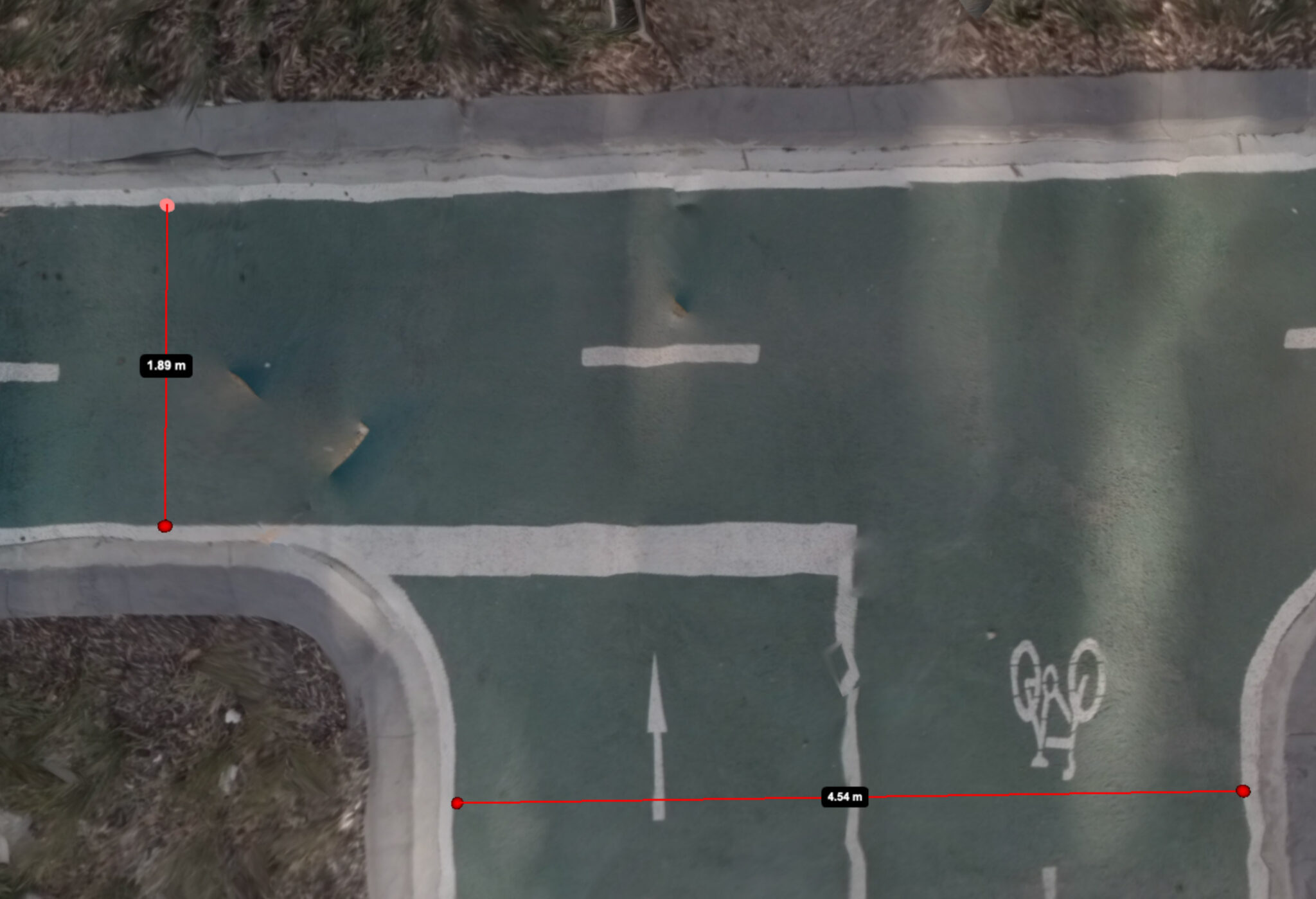
Generated aerial image of a bike lanes with digital distance measurements

Image Source: Jake Coppinger

Companies like Mapillary and Kartaview have played a significant role in advancing OpenStreetMap (OSM) and enabling detailed mapping efforts, particularly in urban areas. While 360° street-level images have been crucial for capturing high-quality data, there is a growing need for a scalable solution that leverages the power of aerial imagery to further enhance community mapping. In this blog post, we delve into the potential of aerial imaging and its implications for OSM mapping. Interestingly, emerging companies in the 360° imagery space, such as Mapillio (Commercial) and GeoViso (Open Source), may view this as an opportunity to add a unique selling point to their portfolio. The process of generating detailed aerial-like imagery for specific smaller areas not only benefits OSM mapping but also proves highly valuable for city planners involved in intersection redesigns or the addition of bike paths to streets.

See full entry

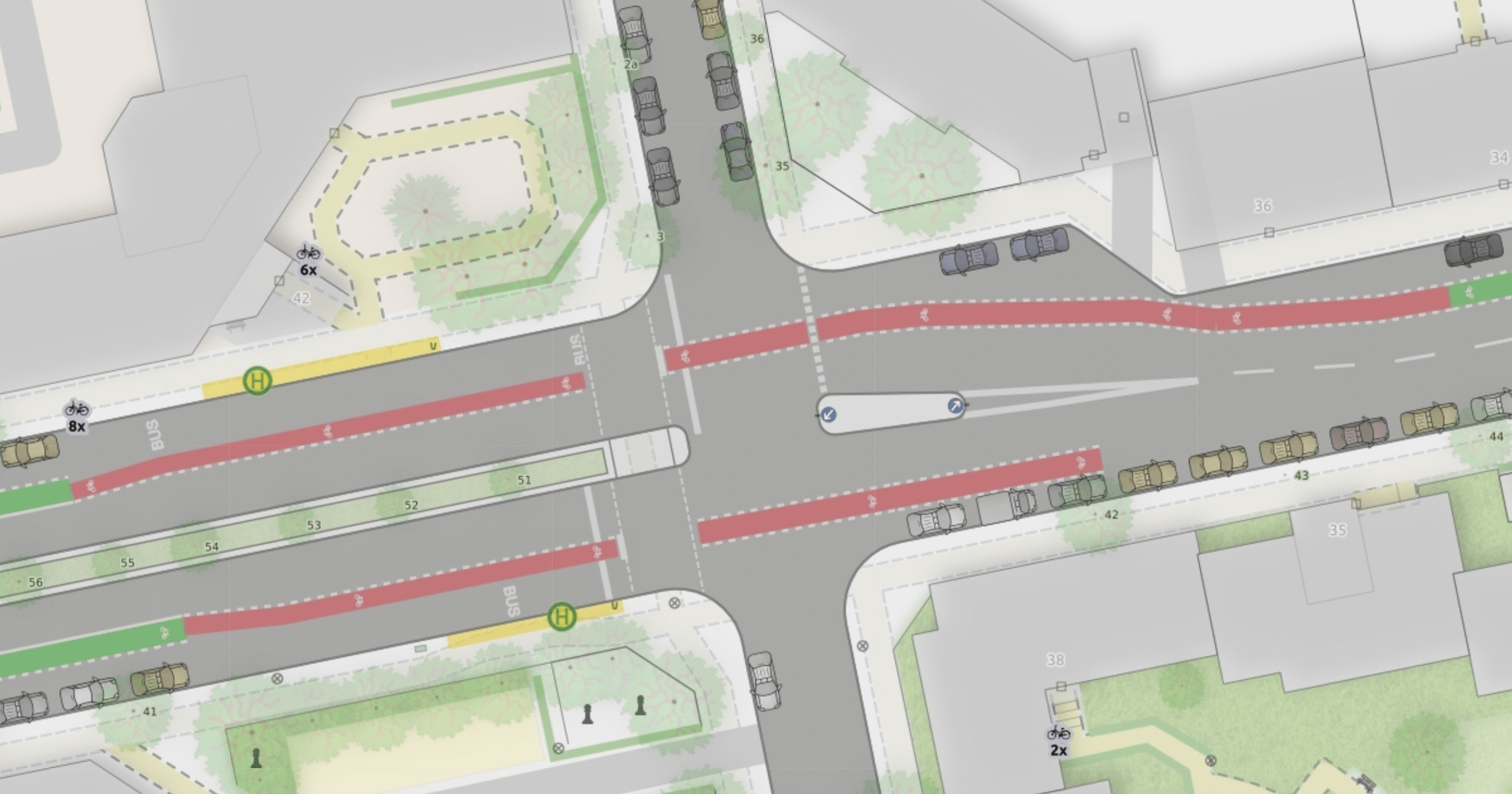
I wrote a blog post to show and explain the many improvements to the “Straßenraumkarte” that Alex @Supaplex030 worked on for the last few month: https://supaplexosm.github.io/strassenraumkarte-neukoelln/posts/2021-12-31-micromap-update

With this public space map for Neukölln, Berlin Alex continues to push the boundaries of the level of detail that can be rendered based on OSM data.

The blogpost shows many interesting details like cycleways, turn lanes and junctions and explains how the data is processed to allow this rendering.

One conclusion is, that a collaboration on pre-processed OSM data for streets would be a huge benefit.


Please use this place here to comment on the blog post.

Ausschnitt der Straßenraumkarte Neukölln mit Details wie parkenden Autos, Fuß- und Radwegen.

Tobias: Hallo Alex, das ist unser Teil 2 auf dem Weg zur Beschreibung deiner größeren Parkraum-Analyse. In Teil 1 haben wir uns angeschaut, wie du mit Hilfe verschiedener OpenData-Quellen ein Bevölkerungsmodell und Autobesitzer-Modell auf Häuser-Ebene erstellt hast.

Jetzt schauen wir uns ein anderes Nebenprodukt an:

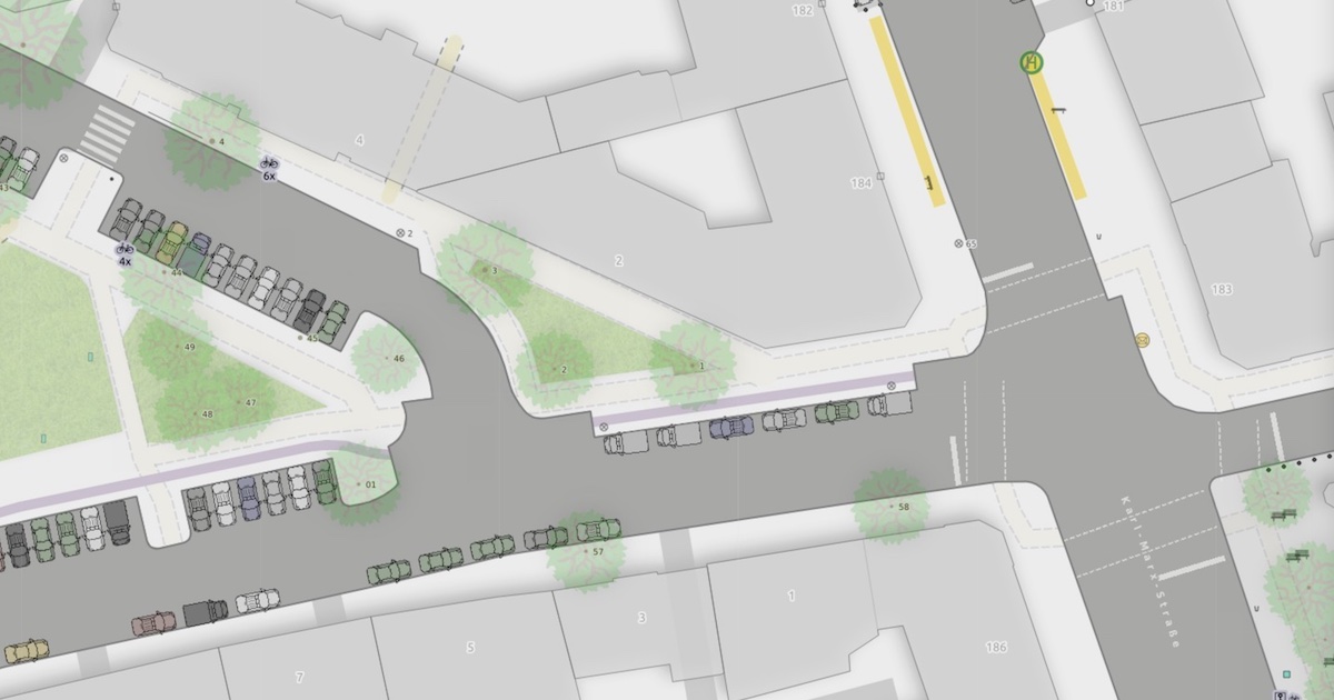
Eine Karte von dem Ortsteil Neukölln in einem ganz eigenen Kartenstil.

Das ist die erste Karte, die ich so kenne, bei der die parkenden Autos anhand des Parking-Lane-Schemas von OSM visualisiert sind. Das gibt der Karte gleich einen ganz anderen Informationsgehalt und auch eine andere Stimmung. Darüber hinaus gibt es weitere Gestaltungsentscheidungen, die ich spannend finde, über die wir jetzt sprechen.

See full entry

Location: Neukölln, Berlin, Deutschland

Ein Interview von Tobias @tordans mit Alex @Supaplex030.

Tobias: Hallo Alex, du arbeitest gerade an einem spannenden Projekt an der Schnittstelle von OSM und der Verkehrswende in Berlin, nämlich einer Parkraumanalyse für den Ortsteil Neukölln. Das ist sehr vielfältig – heute wollen wir uns ein Detail anschauen, bei dem es um OpenData und OpenStreetMap und die Verbindung von verschiedenen Datenquellen geht.

Anzahl angemeldeter Autos pro Haus

Eine Zielsetzung dabei ist, herauszufinden wie viele Autos in einem Häuserblock angemeldet sind. Dafür gibt es keine direkten Daten, aber es gibt Daten über die man Näherungswerte schaffen kann mit Hilfe von anderen OpenData-Quellen und OSM. Und diese Daten hast du dann später in der Auswertung verwendet, über die wir auch noch mal an anderer Stelle sprechen: Eine Karte, in der visualisiert wird, wie viele Parkplätze pro Auto es im Umkreis eines Ortes gibt: https://supaplexosm.github.io/strassenraumkarte-neukoelln/?map=parkingmap

See full entry

Location: Neukölln, Berlin, Deutschland

A year ago I started doing a lot of walking and cycling with my stroller. Naturally, I had to look for new ways to contribute to OSM. More on the go mapping – thank you GoMap! – and more passive contributions by providing street level images.

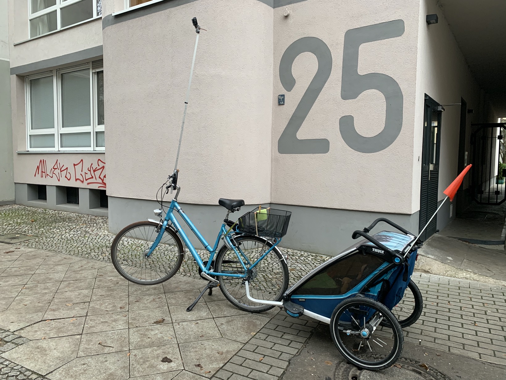
With this post, I want to share my prototype of a bike tripod to take great Mapillary images.

It looks like this:

Picture

Goals of my tripod prototype:

Goal 1: Elevation – Take pictures from as high up as possible

My goal is to create images that allow to map bicycle and pedestrian infrastructure. For Berlin, this requires the pictures to be taken either on the sidewalk itself or from high above on the lane. Otherwise, all you see are parked cars.

Goal 2: Field of view – Look ahead with privacy in mind

No 360°

See full entry

Location: Neukölln, Berlin, Germany