
Mapa interativo permite visualizar dados sobre violações ambientais no Brasil / Interactive map allows viewing data on environmental violations in Brazil.
Posted by raphaelmirc on 14 March 2022 in Brazilian Portuguese (Português do Brasil).Mapa interativo permite visualizar dados sobre violações ambientais no Brasil
Interactive map allows viewing data on environmental violations in Brazil.
O CNJ – Conselho Nacional de Justiça e o PNUD – Programa das Nações Unidas para o Desenvolvimento lançam, através de cooperação, mapa/painel interativo público com geolocalização de ações ambientais, cíveis e criminais em todo o Brasil.
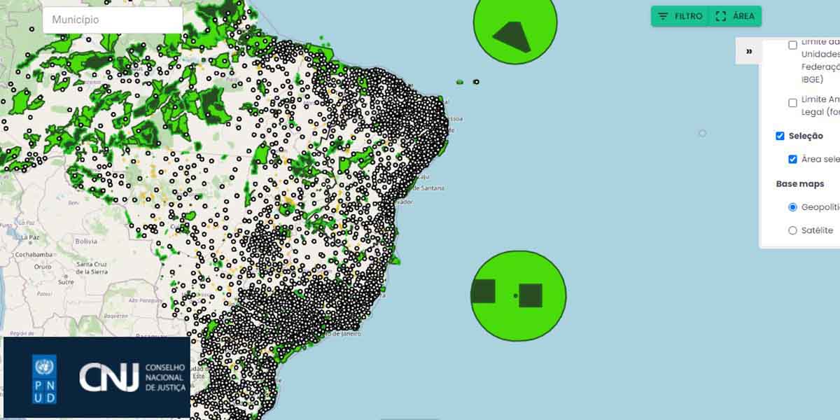
O mapeamento das áreas ameaçadas por crimes e danos ambientais acaba de se tornar realidade para o Judiciário e toda a população. O painel interativo SireneJud tem o objetivo de ampliar a transparência dos dados do Poder Judiciário sobre ações ambientais, cíveis e criminais. A ferramenta foi desenvolvida no âmbito da parceria firmada entre o Conselho Nacional de Justiça (CNJ) e o PNUD, que visa consolidar Laboratórios de Inovação e ODS no âmbito do Poder Judiciário e fortalecer as capacidades do CNJ para a produção de pesquisas em temas relacionados à Agenda 2030.
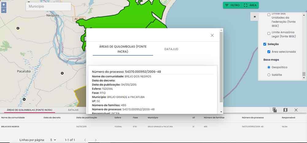
Com cruzamento de dados e georreferenciamento, são identificadas áreas de proteção ambiental, municípios com mais incidência de desmatamento, bem como informações sobre terras indígenas e quilombos e, ainda, indicação dos locais de ocorrência de danos ao meio ambiente discutidos em ações judiciais ou objeto de Termos de Ajustamento de Conduta (TAC), entre outras informações.
Alertas serão gerados para auxiliar o diagnóstico de violações ambientais, aprimorando a tomada de decisão referente ao tema. Desse modo, o painel contribui com o alcance da Meta Nacional 12 do Poder Judiciário, que trata do impulsionamento dos processos de ações ambientais.
O desenvolvimento do painel utilizou uma ferramenta geoespacial, conhecida internacionalmente como Geographic Information System (GIS). Para facilitar o uso e aprimoramento na coleta de dados, estão previstas atividades de formação sobre essas ferramentas, em especial em regiões mais prejudicadas pelos danos ambientais, como a Amazônia.
SireneJud e Agenda 2030
O SireneJud articula-se aos Objetivos de Desenvolvimento Sustentável, da Agenda 2030, ao contribuir especialmente com o alcance do ODS 13, Ação Contra Mudança Global do Clima; e o ODS 15, Vida Terrestre. Ainda, por se tratar de uma ferramenta que impulsionará os processos de ações ambientais no país, contribui para o alcance do ODS 16, Paz, Justiça e Instituições Eficazes. “Por meio da ferramenta, será possível ter uma visão estratégica da realidade das áreas de proteção ambiental do Brasil. Além da contribuição para o impulsionamento das ações ambientais no país, os dados poderão ser utilizados para a formulação de políticas públicas voltadas para a preservação ambiental”, afirma a coordenadora técnica de projetos do PNUD Raíssa Teixeira.
Dada a importância do ecossistema brasileiro no contexto das agendas internacionais, o SireneJud também contribui como mecanismo de acompanhamento dos compromissos assumidos pelo país no Acordo de Paris.
Aplicativo WEB:
https://sirenejud.cnj.jus.br/mapa/geral
Interactive map allows viewing data on environmental violations in Brazil.
The CNJ – National Council of Justice and the UNDP – United Nations Development Program launch, through cooperation, a public interactive map/panel with geolocation of environmental, civil and criminal actions throughout Brazil.
The mapping of areas threatened by crimes and environmental damage has just become a reality for the Judiciary and the entire population. The SireneJud interactive panel aims to increase the transparency of the Judiciary Power’s data on environmental, civil and criminal actions. The tool was developed within the scope of the partnership signed between the National Council of Justice (CNJ) and the UNDP, which aims to consolidate Innovation Laboratories and SDGs within the Judiciary Branch and strengthen the CNJ’s capacities for the production of research on topics related to Agenda 2030.
By crossing data and georeferencing, environmental protection areas are identified, municipalities with the highest incidence of deforestation, as well as information on indigenous lands and quilombos, and also an indication of the places where damage to the environment occurs, discussed in lawsuits or object of Terms of Conduct Adjustment (TAC), among other information.
Alerts will be generated to assist in the diagnosis of environmental violations, improving decision-making on the subject. In this way, the panel contributes to the achievement of the Judiciary’s National Goal 12, which deals with the promotion of environmental lawsuits.
The development of the panel used a geospatial tool, internationally known as Geographic Information System (GIS). To facilitate the use and improvement of data collection, training activities on these tools are planned, especially in regions most affected by environmental damage, such as the Amazon.
SireneJud and Agenda 2030
SireneJud is linked to the Sustainable Development Goals of the 2030 Agenda, especially by contributing to the achievement of SDG 13, Action Against Global Climate Change; and SDG 15, Terrestrial Life. Also, as it is a tool that will boost the processes of environmental actions in the country, it contributes to the achievement of SDG 16, Peace, Justice and Effective Institutions. “Through the tool, it will be possible to have a strategic vision of the reality of the environmental protection areas in Brazil. In addition to contributing to the promotion of environmental actions in the country, the data can be used to formulate public policies aimed at environmental preservation”, says the technical coordinator of UNDP projects Raíssa Teixeira.
Given the importance of the Brazilian ecosystem in the context of international agendas, SireneJud also contributes as a monitoring mechanism for the country’s commitments in the Paris Agreement.
WEB Application:
https://sirenejud.cnj.jus.br/mapa/geral
Raphael de Assis
Discussion