
Just wanted to feed back on the remote mapping that HOT / Missing Maps volunteers did in response to an MSF team based in Doro refugee camp in South Sudan (see the map on reliefweb, here). The message below arrived this week from Guido, an MSF epidemiologist who has just returned from South Sudan.
I don’t think I have anything to add other than well done and thank you! It’s great to see your work at work for NGOs in the field….
Dear Pete, this is Guido, MSF epidemiologist in South Sudan. Greetings from Juba!
We don’t know each other but I realize we have been recently in the same loop of communications about MSF project in Doro Refugee Camp, Maban.
Actually, I am just back from Doro where I have been conducting a multi-antigen vaccination coverage survey.
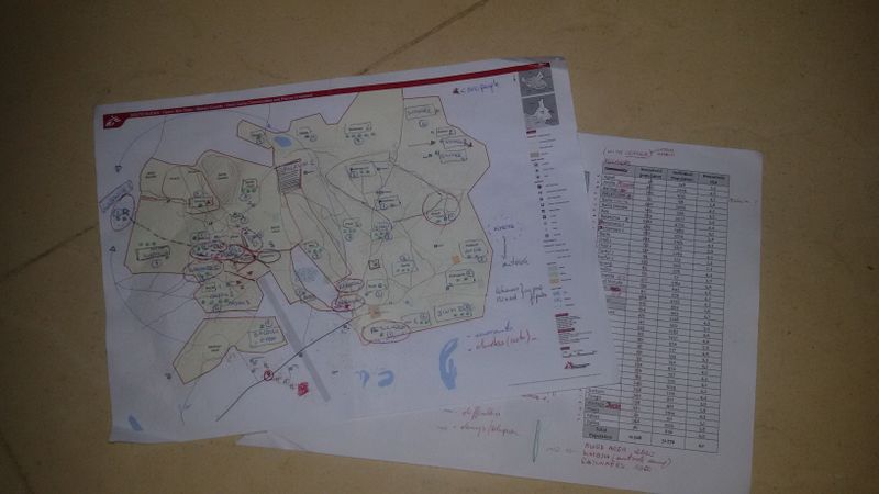
I am writing today because I lately understood that the map that I received in preparation of my survey was actually developed by you and the Missing Map Project Team.
So, I would like to let you know a bit about the survey, and, above all, thank you for your job, since the map was really valuable to us. Actually, I used the map as a basis to prepare the survey: to locate villages (they call “villages” the different parts of the camp, since they relate to the villages of origin in Sudan), to understand the real distribution and presence of people together with the Health Promotion team and to allocate clusters to villages. Basically, it served for the first stage of clustering and it allowed us to save a lot of time in getting a clear picture of the setting; moreover, I felt it was good to let HP team to visualize what they already knew by heart.
In the end, we had to add a few more villages and to account for some recent movements (occurred earlier this year). Then, I admit I was lucky enough to work with Health Promoters, who knew the camp very well and this actually eased the final data collection (i.e. once we had allocated the specific number of clusters to villages, they moved autonomously in the camp… we applied the EPI method and easily accessed all areas).
*Unfortunately, I have no pictures of the teams working since I was advised not to take pictures in the camp… actually, it was not allowed. Nonetheless, I just took a couple of pics of my copy of the map and of a larger copy that I drew on a flip-chart for training purposed. Directly from the field. *
So, this is how it went. I would like to say thhttp://reliefweb.int/map/south-sudan/south-sudan-upper-nile-state-maban-county-doro-camp-communities-and-places-interestat I hope we may stay in touch and we may have soon another opportunity to exchange. In this case, it will be my pleasure to come back to you ahead of time and reasonate together over some maps according to operational needs.
Please, give my best to the Team and thank you very much to you all, again.
Best regards, Guido
Discussion
Comment from robert on 11 September 2015 at 22:36
Looks like you’ve got a subject for next MM evening’s opening mini-talk.