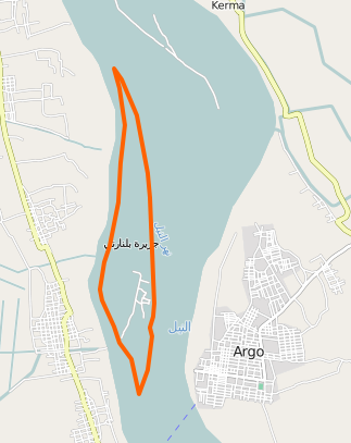
The outer way is tagged as waterway=riverbank (equivalent to natural=water water=river). This means that even if the multipolygon is correct and should make the islands visible, there is another single-way polygon around it which doesn’t care about the islands.
The way you highlighted in your screenshot is not a member of the multipolygon. Add it with role “inner”, like the other islands.
The polygon is tagged water=river but not natural=water. According to the wiki, water=* is a refinement of natural=water, and should not exist without the later. water=* might work on its own for some consumers (like the default osm rendering), but not all.
All islands have apparently been traced from Landsat imagery, but you might want to use Bing or Mapbox, which have a higher resolution.
Hey I reviewed the data in the area, I notice that there are a lot of ways that are parallel to one another, I would suggest getting familiar with multi-polygon relations and utilizing them, otherwise I feel like the data could become a real mess and be somewhat tedious to work with just because of how many ways there will be so close together. If you have any questions please message me.

Discussion
Comment from Vincent de Phily on 8 April 2016 at 09:38
Some of the issues, in order of importance:
Happy fixing :)
Comment from Sunfishtommy on 11 April 2016 at 05:20
Hey I reviewed the data in the area, I notice that there are a lot of ways that are parallel to one another, I would suggest getting familiar with multi-polygon relations and utilizing them, otherwise I feel like the data could become a real mess and be somewhat tedious to work with just because of how many ways there will be so close together. If you have any questions please message me.
Comment from mustafakamil on 11 April 2016 at 20:53
thanks my friends