
If you’re that afraid of AI, stop trying to beat AI at its own game.
Get out there and develop the originality that only humans can bring!!!
 OpenStreetMap

If you’re that afraid of AI, stop trying to beat AI at its own game.
Get out there and develop the originality that only humans can bring!!!
··· I didn’t start contributing to OSM because of any grand philosophy or ideology. I simply began editing because I needed to. But as I became more involved, I learned more about what I believed OSM stood for—openness, decentralization, freedom to collaborate, and a community built around shared stewardship rather than commercial ownership. At least, that was how I came to understand OSM.
That understanding was what motivated me to continue contributing. I chose to spend my time improving OSM instead of Google Maps or the dominant commercial map used in my country. I even spent time studying OSM’s principles and community practices because I wanted to contribute in a way that respected those values.
If utility had been my only motivation, I probably wouldn’t have contributed to OSM at all. In the region where I live, almost nobody actually uses OSM. From a purely practical perspective, my efforts have very little visible impact. Yet I kept contributing because I believed OSM represented something fundamentally different from commercial mapping platforms. That belief—not efficiency or popularity—was what made my contributions meaningful.
For that reason, I don’t believe corporate participation is inherently a problem. OSM is open to everyone, and companies should absolutely be free to use the data and contribute to improving it.
My concern is not that companies participate. My concern is whether, over time, the priorities of the project could gradually shift toward the interests of organizations that naturally have business objectives and far greater resources than individual volunteers. Simply saying that “companies are part of the community” doesn’t fully address that concern. To me, the more important question is not whether companies belong here, but how the community ensures that the values and priorities shaped by volunteers remain just as influential as corporate interests.
Perhaps this is the source of my confusion.
One person is sanding down a rusty gate,
Another is painting over the rust,
Yet another is attaching a new handle to the corroded gate,
Some are even building an entirely new gate to replace the old, rusted one…
And a few are wondering, “Why are they doing all this? The gate still works just fine…“
Everyone is doing what they want to do and what they can do,
but since no one is coordinating or adjusting things,
it’s a situation where people are working inconsistently and in a disorganized manner.
어떤 사람은 녹슨 대문을 사포질하고 있고
또 다른 사람은 녹이 슬어 있는 대문에 페인트칠을 하고 있고
또다른 사람은 녹이 슨 대문에 새로운 손잡이를 달고 있고
또 어떤 사람들은 녹이 슬어 낡은 대문을 교체하려고 새 대문을 만들고 있고…
그리고 몇몇 사람은 대문이 아직도 쓸만 한데 왜들 저러고 있나 의아해 하고 있고……
각자 제 하고픈 일을 하고 할 수 있는 일을 하지만,
누구도 조정해 주거나 조율해 주지 않아서
서로 일관성 없고 뒤죽박죽으로 일하고 있는 형국.

It sometimes feels like OSM is of the West, by the West, for the West.

오픈스트리트맵(OSM)에 꽤 많은 노트(note)가 붙고 있지만 제대로 살펴보는 사람이 적어서 오랫동안 방치되는 일이 많습니다.
살고 있는 지역이나 관심있는 지역에 붙는 ‘노트’ 내용을 RSS로 받아볼 수 있는 방법을 적어 보고자 합니다.
RSS 받기 봇을 쓰면 OSM에서 흔히 쓰는 ‘텔레그램’에서도 그 내용을 받아 볼 수 있습니다.
http://api.openstreetmap.org/api/0.6/notes/feed?bbox=smaller_longitude,smaller_latitude,larger_longitude,larger_latitude에서 ‘smaller_longitude,smaller_latitude,larger_longitude,larger_latitude’ 부분에 그 숫자를 붙여 넣으면 RSS 주소가 완성됩니다.OSM QA Feeds 연장을 열고 찾고자 하는 지역을 검색해 들어간 다음 테두리 상자를 조절하면 됩니다.
이 때에도 한국의 경우 시·군·구 정도의 넓이로 잡는 것이 좋습니다.
Open the OSM QA Feeds tool, search for the region you want to find, and adjust the border box.
A good rule of thumb is to make it about the size of a county. If it’s too wide, it won’t be able to process it and will throw an error.
Democracy without full discussion, anarchism without reconciliation are not my ideals.

헤어질 결심 (영화 정보)
natural=scree, natural=shingle, natural=blockfield

OSM에는 왜 이렇게 흐릿한 갈래가 많을까……
외국 사람들에게 한국의 ‘곰’, ‘탕’, ‘국’을 갈래지으려면 갈래지을 수 있을까?
도대체가 말이 안 되는 짓거리를 언제까지 하고 있을 건가…… ㅡ.ㅡ
Why does OSM have so many fuzzy branches……
Is it really possible to make Korean ‘gom’, ‘tang’, and ‘guk’ forked for foreigners?
How long are we going to keep doing this nonsense…… ㅡ.ㅡ
1,300 HOURS IN A KAYAK - USA / CANADA
ⓒMark Ervin/Youtube

‘힘들지만 가치 있는 여행’이라는 말을 들으면 무엇이 떠오르나요? 산티아고 순례길 걷기? 아니면 자전거 전국 일주? 여기 6800마일(약 1만 1000km) 물길을 카약 하나에만 의지해 다닌 사람이 있어요 🛶. 바로 노르웨이 오슬로에 사는 캐나다인 마크 퍼만 씨예요.
올해 65세인 마크 퍼만 씨는 작년 6월에 카약을 타고 출발해 지난 8월 2일에 목적지에 도착했어요. 그가 노를 저은 시간을 다 합치면 1643시간인데요. 무려 68일 연속으로 1초도 쉬지 않고 노를 저은 것과 맞먹는다고 💪. 뭐 바다라도 건넜냐고요? 그건 아니고, 캐나다 동쪽과 미국 동남쪽 마이애미를 잇는 물길인 그레이트 루프(Great Loop)예요. 퍼만 씨는 홀로 카약을 타고 그레이트 루프를 완주한 최초의 사람이 됐고요(그의 이동 경로 📍).
그가 남다른 모험 정신으로 그레이트 루프에 도전한 건 아니에요. ‘국경없는의사회’ 등 자선단체에 기부할 돈을 마련하기 위해서였는데요. 부정적인 것에 압도되어 살아가는 사람들에게 다시 일어설 용기를 주고, 환경 보호 메시지도 전하고 싶었다고. 그는 여행을 마친 뒤 이렇게 말했어요 🗣️: “지옥 같은 여행이었어요. 하지만 고통을 겪을 만한 가치가 있었어요. 후원자와 자연, 내면 깊은 곳과 연결될 수 있었거든요.”
지물로 인공지형을 만든 곳에 이어, 지물로 어떤 모양을 만든 곳을 모아 봤습니다.(되도록 상업광고를 위한 곳은 빼겠습니다.)
Here’s a list of places where features have been used to create artificial terrain, followed by places where features have been used to create some sort of shape.(I’ve excluded commercial advertisements as much as possible).
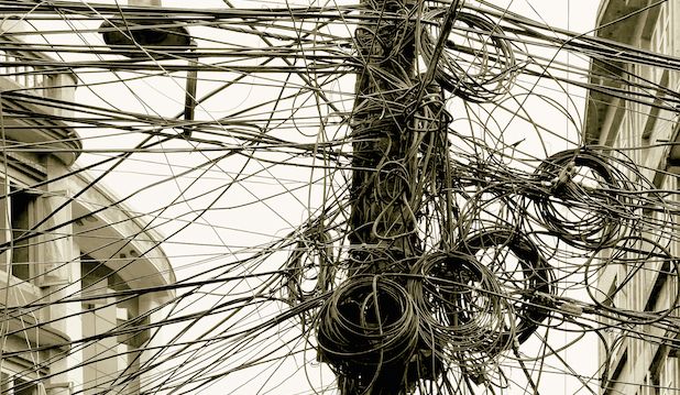
Nowadays, crosswalks are often drawn in an X shape to accommodate pedestrians.
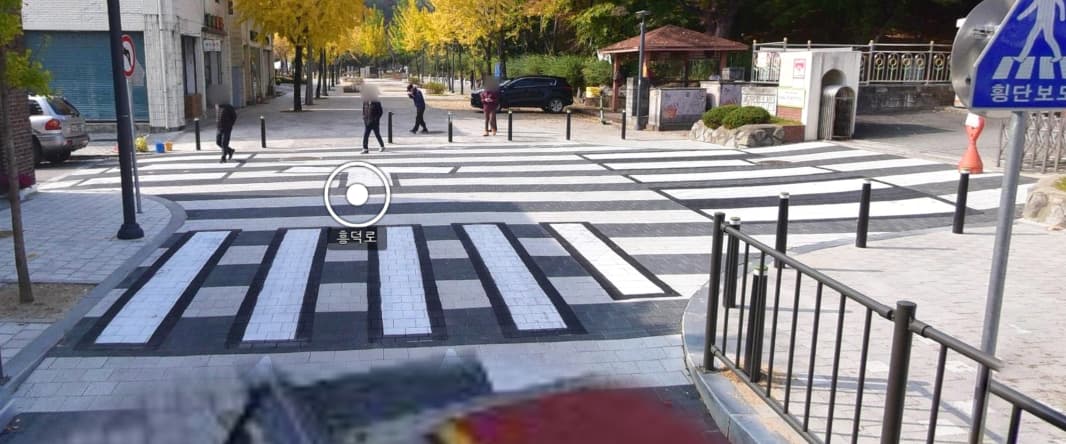
And here we have an entire area designated as a crosswalk.
그들에게 나쁜 뜻은 전혀 없으며, 정보를 더 쉽게 접할 수 있는 곳을 알려주려는 친절한 뜻이라는 것은 믿어 의심치 않습니다만, 그럼에도 불구하고 지역의 문제라면 그 지역 커뮤니티로 안내해 주는 건 이해가 되는데, 단지 언어가 영어가 아니라는 것 때문에 ‘해당 지역 커뮤니티로 가면 더 좋은 정보를 얻을 수 있다’고 하는 건 친절함일까요, 배타성일까요?
그럼 영어가 서툰 아시아 사람은 아시아 커뮤니티에서만 활동해야 하고, 영어가 서툰 한국 사람은 한국 커뮤니에서만 활동해야 하는 걸까요?
거꾸로, 그럼 영어 밖에 말할 줄 모르는 사람은 설령 그 곳이 어디든지간에 영어 커뮤니티 혹은 자국 커뮤니에서만 머물러야 할까요?
언어의 장벽에도 불구하고 다른 커뮤니티에 어울리려는 노력은 아름다운 일이 아닙니까?
왜 ‘OSM UK’는 없는 걸까요?(그런데 ‘OSM US’는 왜 있는 거지요?)
왜 ‘OSM English’는 없는 걸까요?(공식 커뮤니티인 ‘OSM Forum’ 바깥의 비공식 채널들에서)
하고 싶은 말은 훨씬 더 많고 꺼내 놓을 보기 또한 많지만,…… #할많하않
I’m sure they don’t have any bad intentions, and I’m sure they’re trying to be kind and let them know where they can get more information, but if it’s a local issue, it makes sense to direct them to that community, but if it’s just because their language isn’t English, is it kindness or exclusivity to say, “You can get better information if you go to that community”?
Does this mean that Asian people who don’t speak English should only be active in Asian communities, and Korean people who don’t speak English should only be active in Korean communities?
Or conversely, should someone who only speaks English stick to the English community or their own community, wherever that may be?
Isn’t it a beautiful thing to try to fit in with other communities despite language barriers?
Why isn’t there an “OSM UK”?(within OSM Forum. And why is there an “OSM US” anyway?)
Why isn’t there an “OSM English”?(on unofficial channels outside of the official OSM Forum.)
There are a lot of things I could say and examples I could give, but I won’t. #not_much_to_do
먼저, 흔히 광장과 같은 ‘보행자 지역’을 제대로 태그하는 것이 왜 중요한가 하면,…
그런 곳을 ‘영역’(area=yes)로만 태그하면 그 곳을 길찾기(routing), 길 안내(navigating)에서 길을 이어주지를 못 합니다.
따라서, ‘보행자 지역’을 ‘영역’으로 지정함과 동시에 ‘highway=pedestrian’으로 태그하면 영역의 바깥선을 따라 길을 이어주게 됩니다.
가장 좋은 것은 영역으로 지정하되 ‘area=yes’가 아니라 ‘area:highway=pedestrian’으로 하고 동시에 ‘highway=pedestrian’ 하는 것입니다.
참고로 OSM 위키에서는 ‘highway=pedestrian’ + ‘area=yes’ 사용을 추천하고 있습니다.
길찾기가 제대로 되는 것을 확인했습니다.
If I don’t conquer, am I conquered?
오픈스트리트맵 기여자들이 텔레그램에서 좀더 재밌게 소통하고 편한 공간이 되기를 바라면서, 텔레그램에서 쓸 수 있는 OSM 딱지[스티커]를 만들었습니다.
스티커 이미지는 고치거나 더 추가할 수 있으므로 알맞은 이미지나 아이디어가 있으신 분은 알려주시면 고려하도록 하겠습니다.
I wanted to make Telegram a more fun and comfortable place for OSM contributors to communicate, so I created OSM stickers for Telegram.
The sticker image can be fixed or added, so if you have a good image or idea, let me know and I’ll take it into consideration.
You can see all the previews of the stickers by going OpenStreetMap(OSM;오픈스트리트맵)
Please let me know if there is any issue with portrait rights in the above images.
OSM 위키문서에서 ‘길’ 갈래 가운데 주요길 갈래에는 motorway, trunk, primary, secondary, tertiary, unclassified, residential 같은 여러 값이 있습니다.(unclassified는 한국에는 해당하지 않음)
이 가운데 ‘motorway’는 ‘고속도로’, ‘trunk’는 ‘고속화도로’로 또렷하게 갈래지을 수 있겠습니다.(‘고속화도로’는 주요도로 가운데 계층적 성격에서는 살짤 벗어나기는 하지만 그 특성이 또렷하고 독립적이기에 계층적 갈래에 넣어도 문제가 없다고 봅니다.)
나머지는 우리나라 실정에서 갈래짓는 기준에 따라 조금씩 다르게 볼 수 있어 꼭맞게 떨어지도록 갈래짓기는 쉽지 않은 것 같습니다.
그럼에도 한국의 실정에만 맞게 새로 키 값을 만들기도 그렇고, 이왕이면 있는 공통 키 값에 가장 비슷하게 맞물리게 하고자, 여러 길의 속성들을 살펴 볼까 합니다.
먼저, 우리나라 길[도로] 체계부터 알아야 할텐데, ‘관리 주체에 따라’, ‘기능에 따라’ 혹은 ‘사용형태나 규모에 따라, 여러가지로 나눌 수가 있습니다.
“도로법”에 따르면 관리 주체에 따르면, 일부를 제외한 대부분의 노선은 공기업 한국도로공사가 국토교통부로부터 위탁받아 건설, 유지 및 관리를 하고 있는 ‘고속국도’(고속도로), 각 지방자치단체에 있는 지방국토관리청에서 관리하는 ‘일반 국도’, 특별시장·광역시장이 관리하는 ‘특별시도·광역시도’, 그 밖에 시장·도지사가 관리하는 ‘지방도’, 시장·군수·구청장이 관리하는 기타 군,시도 그리고 역시 시장·도지사가 관리하는 국가지원지방도(국지도)가 있습니다.
그렇다면 크게는 ‘고속국도’, ‘일반 국도‘그리고 광역 지자체장이 관리하는 ‘특별시도·광역시도’와 ‘지방도’를 묶어서 ‘지방도’, 시장·군수·구청장이 관리하는 ‘시도·군도·구도’ 정도로 뭉뚱그려 나눌 수 있지 않을까 싶습니다.
그 밖에도 차선 수나 넓이에 따라 나누기도 하고, 기능에 따라 ‘주도로’, ‘간선도로’, ‘집산도로’, 규모에 따라 ‘광로’, ‘대로’, ‘중로’, ‘소로’처럼 나누기도 하나 그 나눔이 그리 또렷하지는 않은 것 같습니다.
OSM의 계층적 분류에 따라 ‘고속국도’(고속도로)는 ‘highway=motorway’로, ‘일반 국도’는 ‘highway=primary’, ‘지방도’는 ‘highway=secondary’, 그 밖의 ‘시도·군도·구도’는 ‘highway=tertiary’로 나눌 수도 있을 것 같은데, 개념 상으로는 구분이 뚜렷하고 별 문제가 없으나, 일반 사람은 쉽게 알기 어려운 정보가 들어 있어, 이와 함께 좀더 알기 쉬운 기준과 함께 정리를 해 볼까 합니다.
먼저, 여러 분류 기준 가운데 가장 확실하고 ‘그나마’ 또렷한 기준은 ‘관리 주체’를 기준으로 한 분류겠으나 판단하기가 까다롭거나 어렵기 때문에, 국토지리정보원에서 제작한 지도를 기본으로 하고 있는 국토부 ‘브이월드‘나 상업지도 가운데 일부는 색깔로서 비교적 또렷하게 구분을 해 주고 있어 참고를 하기가 좋습니다.
