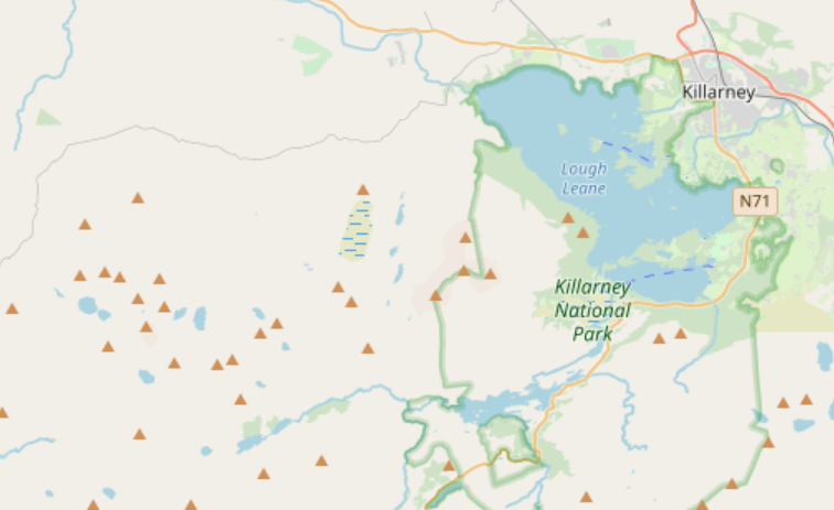
There are a lot of peaks mapped in OpenStreetMap, ranging from proper mountains to mere pimples. They’re usually rendered the same regardless of how high they are:
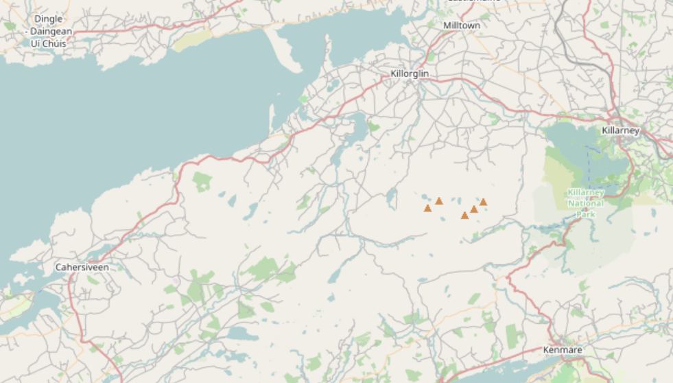
However, with a bit of preprocessing and a bit of help it’s possible to render higher ones at a higher zoom level:
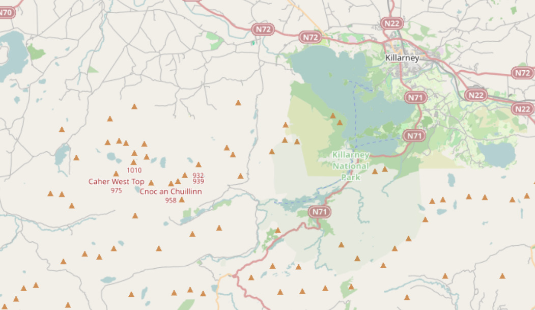
and when all are displayed, only display the names of the higher ones:
It’s also possible to make use of the topographic prominence if we have that data too (as there is for lots of peaks in Scotland):
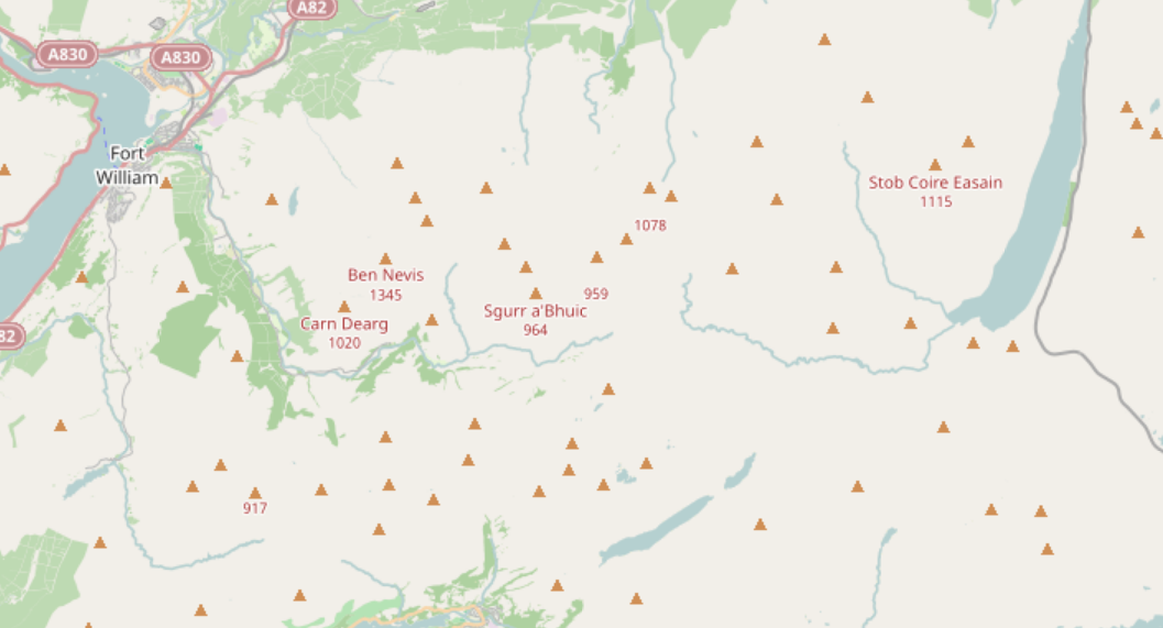
In that example we’re deliberately not emphasising Sgùrr Eilde Mòr, not named in that image, because its prominence is only 271, despite it being over 1000m high, whereas Stob Coire Easain is shown sooner because it has much greater prominence.
Discussion
Comment from Pedja on 9 November 2019 at 06:31
This should be default in OSM rendering.
Comment from pangoSE on 9 November 2019 at 07:46
This is good Andy! Could you contribute this to CartoOSM?
Comment from yvecai on 9 November 2019 at 09:39
Why the pre-processing? Is ORDER BY “ele” not sufficient?
Comment from SomeoneElse on 9 November 2019 at 10:21
@yvecai The general answer to “why pre-processing” is that it makes the OSM-Carto code much easier to write and to understand - just add the pseudo-values like “bigpeak” to the selection in project.mml and add the extra display code here and here.
More specifically, it’s doing a bit more than an “ORDER BY” - the lua code first looks at peaks with an “ele” more than 914m (3000 feet in old money - the height that is the differentiator of a munro in Scotland). It then tries to infer the prominence if it isn’t set. Firstly it assumes that it’s the same as the elevation, but if the “munro” tag is set but prominence isn’t, then it’s likely to be a “munro top” - over 914m but still on the way up the primary mountain, and so it assumes low prominence in that case. This “prominence guessing” works in Scotland but not very well elsewhere (in particular sort the list here by prominance and compare to Kerry here), but it’s better than nothing, and as people start mapping actual prominence the need to guess it goes away.
As an aside, I believe that the prominence data in Scotland comes from the Database of British and Irish Hills. There’s a bit of background on that on talk-gb here and here, and on this changeset among others. I’m pretty sure that the prominence data doesn’t come directly from the OS; the question is whether it is derived from data that does. We certainly do have permission from someone from DoBIH to use it. If it does turn out to be valid to use within OSM it’d be good to see the missing prominence data in Wales, Ireland, England and the rest of Scotland added.
Comment from SomeoneElse on 9 November 2019 at 10:36
@Pedja @pangoSE The standard OSM Carto stylesheet has been reluctant to add significant pre-processing. I suspect that one of the reasons why is that it does tie the display of new features to a database reload. I do one every few weeks on average and it doesn’t take long to do. In this graph the period from 00:00 to 03:00 is the database load, and from 03:00 to 13:00 is just applying missing diffs. If you wanted to render the whole planet at any significant level of detail the time to load would lead to noticeable downtime, so you’d probably need two rendering servers; one to serve “old style” tiles while the “new style” one was being reloaded. That’s not impossible to do, but it’s a major change to how things are done now, and I suspect people would think that the effort to do that would be better spent in other areas (and I’d probably agree).
Comment from imagico on 9 November 2019 at 14:35
A comment on both the original post and the idea of having something like that in OSM-Carto - the problem with the prominence tag for peaks is that it is computable and at the same time in the general case practically non-verifiable except through computation using external data. Therefore it is IMO not suitable to be stored in OSM.
From a cartographic perspective other importance measures for peaks are also much more suitable than prominence and tend to be simpler to compute at the same time. See:
osm.wiki/User:Maxbe/Dominanz_von_Gipfeln
Comment from Pedja on 10 November 2019 at 01:23
Ham radio SOTA program uses prominence to sort peaks in ten groups. Some SOTA peaks are designated in OSM database. Maybe that could be used.
Check http://www.sotadata.org.uk/summits.aspx (it is UK site but data covers number of countries).
Comment from SomeoneElse on 11 November 2019 at 20:04
@Pedja Thanks for that. Maybe I’m missing something but I don’t see any prominence data there? However:
@imagico I’m guessing in “computable and at the same time in the general case practically non-verifiable except through computation using external data” the missing external data that you’re referring to is the saddle elevation between peaks (basing it of this explanation)? That’s measurable, but doesn’t tend to be in OSM.
Linked from the previous site are a couple of options - there’s a fusion tables link (which will go away in a couple of weeks) and also a link to https://github.com/edwardearl/winprom which offers a plausible way to download some SRTM data and process that. However, it’s not a small job - here are “peaks by prominence” where I happened to be yesterday (here in OSM. As you can see, OSM has 4 peaks there (which I definitely noticed!), and the prominence map “only one of note”. Many more prominence values would need to be calculated than the “everymountainintheworld” version.
Comment from Pedja on 12 November 2019 at 00:40
Prominence is very hard to calculate.You need lots of computations to get there and only if you have solid data. SRTM unfortunately is not near good enough for most of the planet.
Unfortunately, SOTA program does not show exact prominence, but each peak points are valued from prominence, so it might be useful as it points out which peaks do have significant prominence.
Comment from Pedja on 12 November 2019 at 00:44
Here is list of SOTA peaks so far mapped in OSM: http://overpass-turbo.eu/s/O1p
Comment from SomeoneElse on 12 November 2019 at 10:33
@Pedja Ah - I see what you’re saying now! Yes, the list at http://www.sotadata.org.uk/summits.aspx are indeed the “most prominent peaks” (and certainly all the English ones are missing prominence data in OSM).
Comment from akirmse on 25 July 2020 at 04:47
Hi there, you’re probably already aware of this, but I have a global prominence calculation with results available at http://www.andrewkirmse.com/prominence. SRTM is indeed good enough for most purposes.
There’s also a visualization at http://everymountainintheworld.com for the most prominent peaks (the calculation includes many more than this).
Comment from Pedja on 26 July 2020 at 09:52
@akirmse My best compliments for hard work! Kudos!