Now it is one week since I started working with OSM. Sadly, my initial enthusiasm has waned. While there were many nice experiences, above all encountering some helpful fellow mappers, a feeling of meaningful connection with the purpose of the project did not develop.
The apps I used show little consideration for what’s meaningful to the average mapper or end user. The below example from iD may serve as an illustration for how haphazardly it has been decided what gets displayed and what gets hidden. This matters because the UI displays no settings button to override that decision.
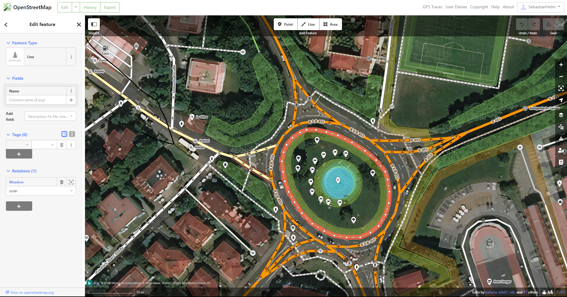
- The fortunate few that get to display their name include some street signs such as city limit signs (for which iD displays the full official name of the city at a place where it makes sense to hardly a mapping task – see the name “Königstein im Taunus” at the right edge of the picture), individual bus platforms or stopping locations (thus displaying the name of some feature at various locations far away from the actual feature - see the name “Kreisel” displayed four times, including two times as far away as the upper left edge) and even doggie bag dispensers (such as this one whose name was repeatedly added and removed).
- The map displays a big white balloon symbol for each bollard, fire hydrant or driveway end.
- The lower right side displays “Edits by” with some user names. One might think that that has some pertinence to the area shown. But when one clicks on any of them, the new page has no information about the area shown – it’s just the user page. So the display of that narrow selection of user names (in this case, 3 out of 51) seems pointless.
- At the top of the page, a big white rectangle contains some links, only a couple of which are related to the map shown. Most of that rectangle is a waste of space that could much better be used to display more of the map, the working area of which currently is reduced to an unwieldy 2:1 aspect ratio. The few relevant ones could easily be included in the darkened rectangle overlaying the top of the map.
- At the same time, important information is not displayed. To wit: Of the six roads that yield into the roundabout in the example picture, none has a name displayed.
- Other information that would be nice to see on the map when editing include house numbers and some indication of number of parking spaces (example: The underground parking “Parkhaus Stadtgalerie” with 200 spaces is shown with just a standard size balloon between many others, while the nearby “Stellplätze REWE” – just a small parking area with 6 spaces – gets to display its name prominently).
One may justly consider these as small kinks that one can get used to. However, they add up to a disconnect between the mapper on one side and the real world and the needs of those who use the data on the other side. I often asked myself “Who cares?” – not just as a rhetorical question, but because I really felt no connection to anyone in the real world who would care. (Example: the name of a doggy bag dispenser. Sure, the company that provides them will have some employees who will care about their product name, but does anyone in the company even care whether OSM highlights that name? Who knows whether, even if I entered that name a thousand times, I would get so much as a thank you note?) This example may be an extreme case, but even looking at road surfaces – something I care about when riding my bike, and one of the most established tags in OSM – who in the real world cares whether OSM lists it as “fine gravel” or “compacted”? If I were an earth worm I would care, but then I wouldn’t be using OSM.
I think this is enough for a diary entry; if there is demand, then I could write more about the following topics:
- Basic information for beginners
- Terminology
- Simple tasks I wasn’t able to accomplish with iD
- Experience with StreetComplete
- Experience with the wiki
Discussion
Comment from SK53 on 7 October 2021 at 09:18
I think there are some things which you can do with the editor which will address some of these criticisms:
I can’t address all your other points, but a few other things:
I do think it’s interesting to hear your perspective on the other topics.
HTH,
Jerry aka Sk53
Comment from SebastianHelm on 7 October 2021 at 11:02
Thank you, Jerry.
BTW, it took me some time to find that tab; it seems to have some strange behavior. Initially, none of the tool tips of the icons on the right edge said “Map Data”. One of them, presumably the one below the layers symbol, opened a dialog that had a check box that said something with “Map Data”. I selected that and – voilà – since then the tool tip for that symbol displays “Map Data”, and the dialog it opens now contains a section called “Map Features”, where I can select individual features (apparently to be displayed in non-edit mode). (I wrote “strange behavior” above because I can’t repro this, since I now don’t see that “Map Data” check box anymore.)
Kind regards, Sebastian
Comment from Richard on 8 October 2021 at 10:36
You’re welcome to, of course, but it wouldn’t be a very effective use of your time. OSM has plenty of people with bright ideas about how things could be improved. We’re less blessed with people prepared to put in the work to actually do it. If you have programming skills then you could try tackling a few issues on iD or the website; if not, you could perhaps put some hours into sorting out the wiki.
Comment from TonyS999 on 17 October 2021 at 11:50
Hi Sebastian, I was a newbie about 3 years ago, and I had and still have serious reservations about iD - I can only use it for the most trivial things. After some searching I found JOSM - an editor - which I was able to download onto my PC. It has a user interface which can be heavily tweaked to select what can be highlighted and allows multiple data sets to be overlayed. JOSM is closer to the software development world I previously inhabited. Other tools caught my eye - but look at osm.wiki/Editors to get some idea.
Welcome to OSM, I hope you stay around. I live in a part of England which was relatively uncharted by OSM, and I am adding a lot of information which I find useful and I hope others do also. I encourage you to continue as I have, the amount of knowledge I have gathered about my local town is phenomenal - and OSM lets me store it for others.
Tony
Comment from fnuttens on 18 October 2021 at 07:12
Hi Sebastian,
Maybe I can address your 3rd issue, which is related to the “Edits by” list. If you click on the “and X others” button, it will take you to OSM’s history, which can tell you accurately who edited what feature(s). As opposed to the summary provided by iD, OSM’s built in history is comprehensive. Hope this helps !
Best regards,
Florent
Comment from SebastianHelm on 18 October 2021 at 11:20
Thanks to both of you who replied in the last few days. (I thanked Richard privately).
Tony: I currently am not very active here, but I will install JOSM when I do more. The other editors listed on the wiki page are interesting, too; I might install one of them on my cell phone.
Florent: From the history page you describe, I see no way to get the history of a specific feature. E.g. from the screen shot in my OP, I get just another map view, which doesn’t even display my selection anymore. The only potentially interesting thing related to history is one orange line crossing it; presumably part of the border of some bigger changeset affecting some features in the displayed area.
The sidebar shows entries such as the following:
Created about 4 hours ago by wheelmap_visitor · #112638703
0
Not very informative – in general, the whole sidebar shows no information in any way related to the feature of interest. Even when I go further, checking individual sidebar entries, I see nothing that points to the selected feature. Or am I missing anything?
Comment from fnuttens on 18 October 2021 at 12:07
I’m afraid I didn’t give you the best location to illustrate the history’s value, sorry 😅
Sometimes changesets are more broad than others, thus they cover a big surface, just like you guessed. In this case, the history might not be the best tool for the job, I’ll give you that.
If you browse locations with more small-scale changesets, though, you will see a more fine-grained changelog of the area. See this example. You can load more changesets by clicking the button at the bottom of the list.
I understand that your need is to get the history of a specific feature. To do that, the first step is to find the ID of the feature of interest, for example way/480798708. I know 2 ways of doing that :
Once you are on a feature’s detail page, there’s a button that links to its own history. See way/480798708/history for example.
Finally, I heard of this tool called whodidit that lets you find which user modified a specific feature, but I haven’t toyed with it yet.
Comment from SebastianHelm on 18 October 2021 at 12:53
Thank you, your second last paragraph addresses exactly what I need.
BTW, funny name on your example map: « Alllée des Chuchotements ». Do you know the history of that name, by any chance?
Kind regards, Sebastian
Comment from fnuttens on 18 October 2021 at 13:30
Glad I could help 😀
Well, I didn’t know its history but since you asked I did some research! Here’s what I found : this alley was built around 2004, along with the Jardin des Deux Rives (a public garden). A few alleys lead to or cross the garden. Each of them has a theme.
The theme of the “alley of whispers” is communication. The city built quite a few benches (I know I know, I’ve got some work to do here, most of them are not mapped in OSM yet ^^), so that the people could become closer. I guess the name comes from the sound of people chatting one could hear when approaching the alley. Sorry to disappoint if you expected a ghost story with creepy whispers among the trees 🤷
Sources :
Regards,
Florent
Comment from SebastianHelm on 19 October 2021 at 07:41
Thanks for the research. It looks like, when they named the street, they intentionally picked a word with richer connotations than those of alternatives such as « bavardage ». Similarly, according to your second source, they named a path for cyclists and roller skaters « chemin des pensées ». 🙂
Speaking of terminology, your first source uses the German word „blockhaus“ in a sense I hadn’t known yet. So I now learned that there is not only this civil sense, but also Blockhaus (Militär).