
Web map of colaborative mapping for the Disaster Risk Reduction (DRR)
Posted by Raquel Dezidério Souto on 12 February 2024 in English. Last updated on 15 February 2024.Information for the disaster risk reduction (DRR) in the Municipality of Maricá (Rio de Janeiro, Brasil)
Contextualizing
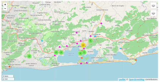
This web map is part of the development research that aims to provide a mapping platform for official and collaborative data, within the scope of disaster risk reduction (DRR), as this type of catastrophic events is increasing its frequency of ocurrence in the state of Rio de Janeiro (Brazil) in the last years. The municipality of Maricá is the pilot area of interest (AOI). The reader can also visit the dynamic map of this same area of interest at uMap.
The mapping and development of the collaborative platform are coordinated by Dr. Raquel Dezidério Souto (IVIDES.org), in cooperation with a group of mappers of the YouthMappers UFRJ. To keep contact, please, send an email to ivides@ivides.org or answer this form.
The web map is being developed in WordPress and Leaflet Map and the initial list of layers is showed below. The web map has some background layers (WTMS) aplicable to this case (DRR mapping): OpenStreetMap, HOT-OSM (Humanitarian OpenStreetMap), * OpenTopoMap* and Esri World Imagery.
Initial layers
Areas subject to inundation and flash floodings – Freitas & Freitas (2022) – in progress
Areas subject to mass movements – Freitas & Freitas (2022) – in progress
Churches and temples – IBGE (2022 Demographic Census); OpenStreetMap – in progress
Classification of the coast in terms of vulnerability to coastal erosion – Lins-de-Barros (2005) – in progress
Clinics and health posts – IBGE (2022 Demographic Census); Maricá Municipal Health Department (2024); OpenStreetMap – in progress
Geological alert and alarm stations (EAAG) – Secretariat of Protection and Civil Defense of Maricá (2024) – COMPLETE (07 Feb. 2024)
Hydrants – Rio de Janeiro State Fire Department (2024) – in progress
Hydrological alert and alarm stations (EAAH) – Secretariat of Protection and Civil Defense of Maricá (2024) – COMPLETE (07 Feb. 2024)
Hydrological monitoring stations - Secretariat of Protection and Civil Defense of Maricá (2024) - in progress
Hospitals – IBGE (2022 Demographic Census); Maricá Municipal Health Department (2024); OpenStreetMap – in progress
Hotels and inns – IBGE (2022 Demographic Census); OpenStreetMap – in progress
Meteorological monitoring stations - Secretariat of Protection and Civil Defense of Maricá (2024) - in progress
Schools (public and private) – IBGE (2022 Demographic Census); Maricá Municipal Education Department (2024); OpenStreetMap – in progress
Villages; Localities – OpenStreetMap – in progress
SDG 2030
This research is related to the following United Nations Sustainable Development Goals - 2030 Agenda:
![[SDG 3]](https://ivides.org/wp-content/uploads/2024/02/ods3-e1707358082863.jpg)
![[SDG 11]](https://ivides.org/wp-content/uploads/2024/02/ods11-e1707358118285.png)
![[SDG 13]](https://ivides.org/wp-content/uploads/2024/02/ods13-e1707358145719.jpg)
![[SDG 17]](https://ivides.org/wp-content/uploads/2024/02/ods17-e1707358165162.jpg)
Data source references
Corpo de Bombeiros Militar do Rio de Janeiro
Freitas, Alessandra C. de; Freitas, Fabíola S. de. Prática educativa voltada à redução dos riscos e desastres hidrológicos da cidade de Maricá, RJ. In: SOUTO, R.D. (org.). Gestão ambiental e sustentabilidade em áreas costeiras e marinhas: conceitos e práticas. Vol. 2. Cap. 22. Rio de Janeiro: IVIDES.org, 2022. 768 p. Disponível em: https://ivides.org/livros.
Instituto Brasileiro de Geografia e Estatística - IBGE.
Lins-de-Barros, Flavia Moraes. Risco e vulnerabilidade à erosão costeira no município de Maricá. Dissertação de Mestrado – Universidade Federal do Rio de Janeiro, Rio de Janeiro, 2005. Disponível em: http://objdig.ufrj.br/16/teses/648563.pdf.
Maricá Municipal Department of Education - RJ
Maricá Municipal Department of Civil Defense and Protection - RJ
Discussion
Comment from pedrito1414 on 13 February 2024 at 10:31
Thanks for sharing. Look forward to seeing how this develops….
Comment from Raquel Dezidério Souto on 15 February 2024 at 14:51
Thank you, pedrito1414, Let’s stay in contact :)
Comment from mapeadora on 22 February 2024 at 15:44
Congrats Raquel! I personally think that uMap is extremely useful, and it’s key not to make local governments dependent of an infrastructure they would have to pay for (and then typically lose after administrative time). I’ll be very curious to know if the experience is scaled/ replicated in other municipalities in the future. Cheers
Comment from Raquel Dezidério Souto on 24 February 2024 at 02:29
Dear mapeadora, Thank you so much. Yes! FOSS is powerful and very important to the public administration too, because of the nature of the public data (public domain). It is worrying to include this type of data in private (not open) repositories. OSM appears to be a solution that meets all these requirements. And Maricá City is our pilot (initial) municipality. So, keep in touch for more news! Cheers from Rio! 🌿