z-dude's Diary Comments
Diary Comments added by z-dude
| Post | When | Comment |
|---|---|---|
| How do you map house numbers efficiently? | some people interpolate numbers based on house numbers at the start and end of a street. I think they use Josm. You typically see 2 rows of dots with just address information. This works in grid style streets in North America where street numbers increment on a known rate. This may not work well in older towns where the streets follow spaghetti network. |
|
| new useful proposal | I disagree with the idea of tagging clouds. People have already tagged the limits of the hires imagery in the past, but in some cases, the imagery has been updated, but the relations have not been updated. To a casual mapper, updating relations can be a confusing task, especially on odd shapes or relations with many parts. An example - high res imagery boundary in Mali http://www.openstreetmap.org/relation/2770026#map=6/19.280/0.780 I’d rather see ‘fixme’ tags on roads which have been interpolated under cloudy imagery. |
|
| Automated Street name abreviation replacements | Automation gives you results like Street Elmo’s Street |
|
| La cartographie humanitaire OSM évaluée par la croix-rouge US et REACH | You may want to consider the use of drones and a camera to get aerial imagery. |
|
| Important unpaved roads exist, so wiki.openstreetmap.org/wiki/Highway needs a reboot | My experience has been that people are trying to force their personal standards over other people. I don’t recognize the Proposed Africa page as valid due to the current lack of participants in it’s discussion, and I don’t think a handful of people on that page have the authority to tell OSM how to map the roads of a billion people in Africa. When you go and delete someone’s ways because they drew a track instead of a primary road, then there’s something wrong with your people skills. |
|
| Egypt-Sudan Un-correct Border JOSM help | The US Canada border loosely defined as ‘49th parallel’ is actually hundreds of segments defined by precisely measured monuments. See the http://internationalboundarycommission.org/ 49th parallel segment http://internationalboundarycommission.org/coordinates/M49thp.txt |
|
| Lost city in Darfur | Great work with the Wiki article! |
|
| Lost city in Darfur | There’s 2 camp-like spots about 40 km’s west of Buram. Perhaps that’s the real location of Gereida. http://tools.geofabrik.de/mc/?lon=24.34983&lat=10.77741&zoom=11&num=2&mt0=mapnik&mt1=bing-satellite |
|
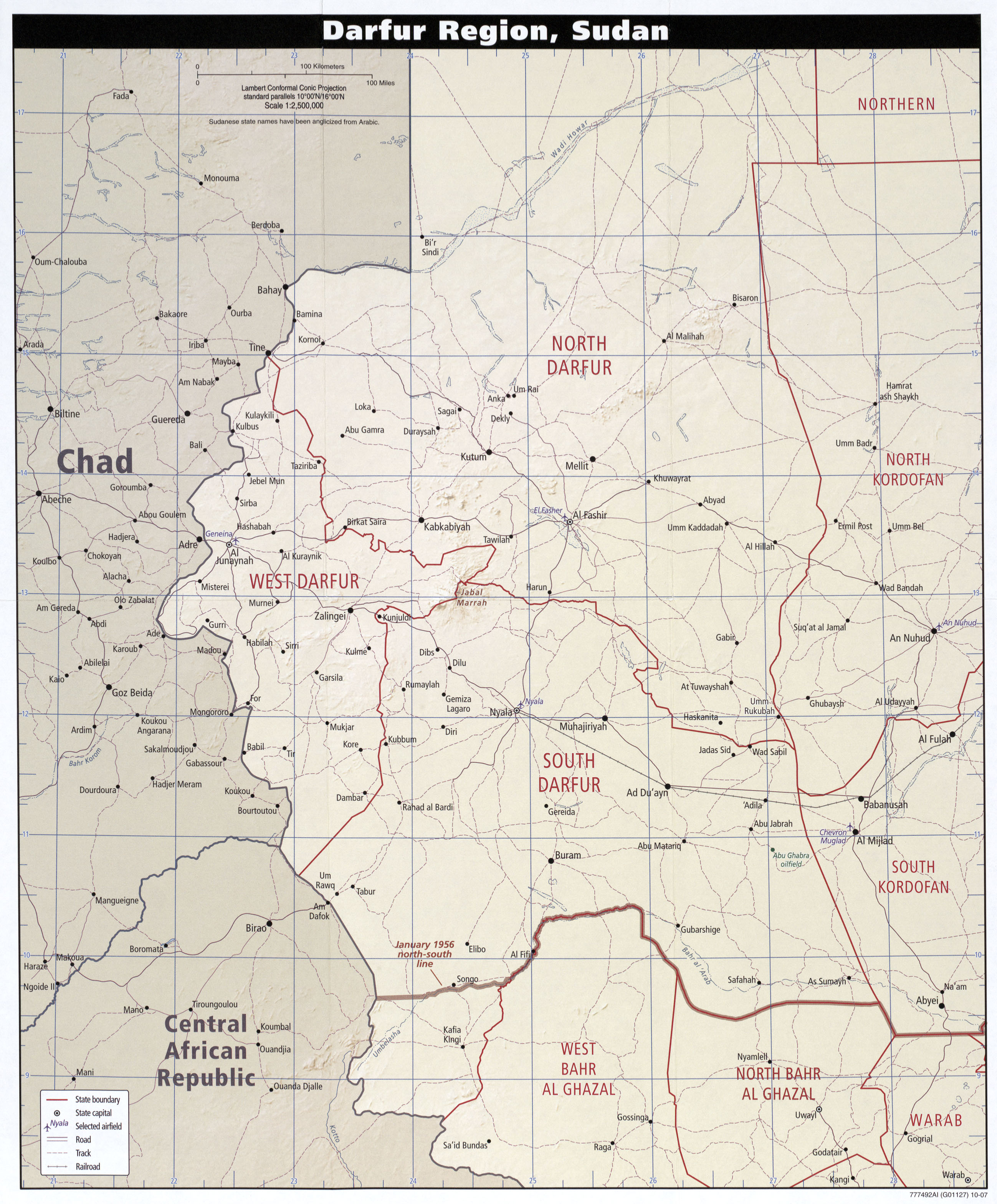
| Lost city in Darfur | I’m sure that it’s Gereida because the coordinates match the UN map http://www.lib.utexas.edu/maps/africa/txu-oclc-224306541-sudan_darfur_2007.jpg The size of the city matches the approx 120,000 people there. I think Gereida needs it’s own Wikipedia article.
The population was 120,000 in 2008 This UN map has a ‘Gerida’ I’m not sure if that’s the name of a small village before 130,000 people moved in. http://unamid.unmissions.org/LinkClick.aspx?fileticket=SOZJ9VBg2Ag%3D&tabid=11744&language=en-US This UN map calls it Graida http://www.un.org/Depts/Cartographic/map/dpko/unamid.pdf This UN map calls it Gereida. http://reliefweb.int/map/sudan/sudan-reference-map-september-2012 Unicef shows ‘Gerida’ http://www.unicef.org/mena/MENA-UNICEF_Sudan__-September_2013_SitRep-_External_Version.pdf Oxfam calls it Gereida http://www.oxfam.org/en/programs/emergencies/sudan/sudan_gereida_dayinthelife I think most of the aid groups call it Gereida. This BBC story says that Oxfam pulled out of Gereida in 2007 I think you’re doing a great job mapping these two cities. |
|
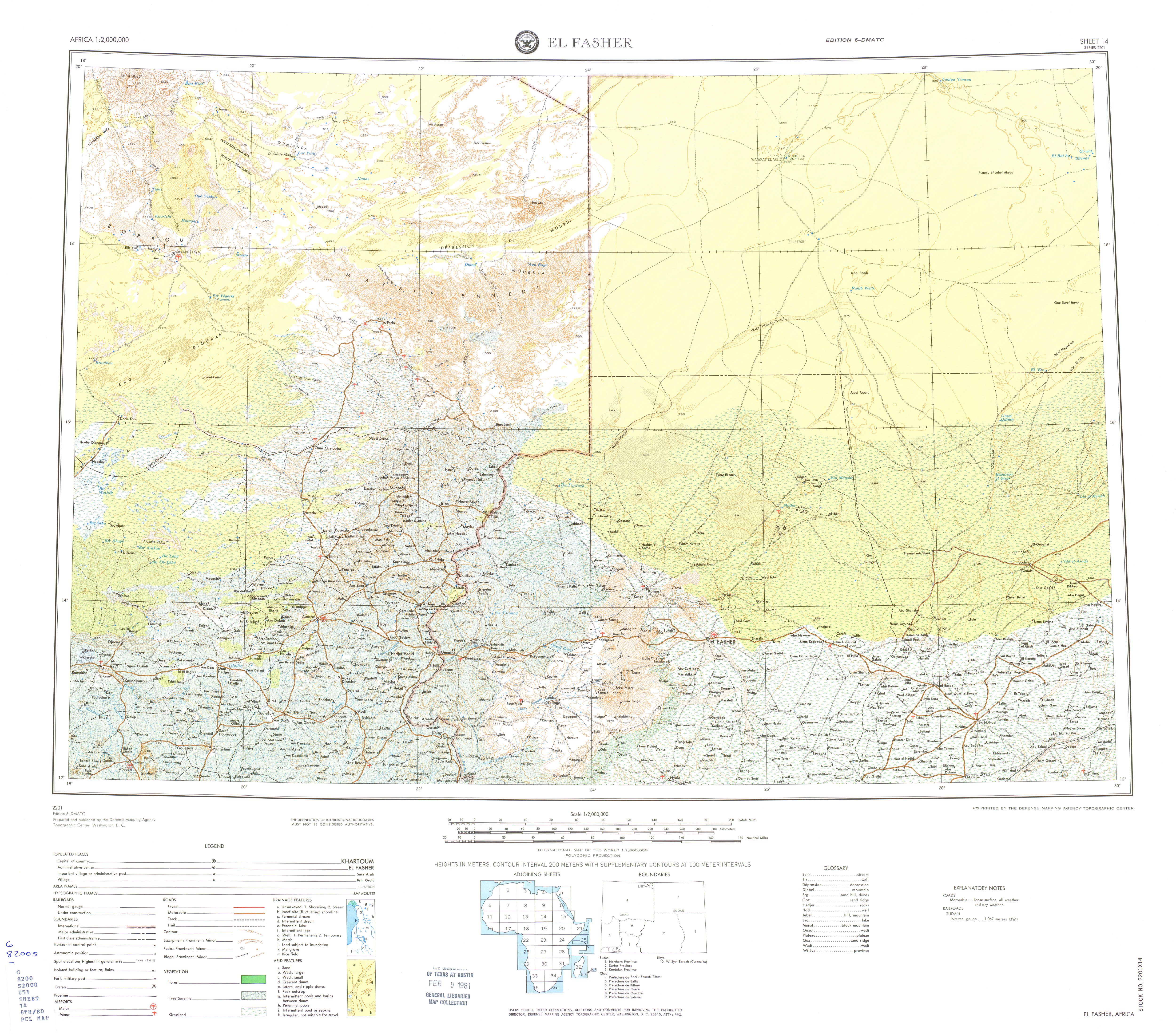
| Lost city in Darfur | Sheet 14, above, shows Nyala. http://www.lib.utexas.edu/maps/ams/africa/txu-oclc-6589746-sheet14-6th-ed.jpg |
|
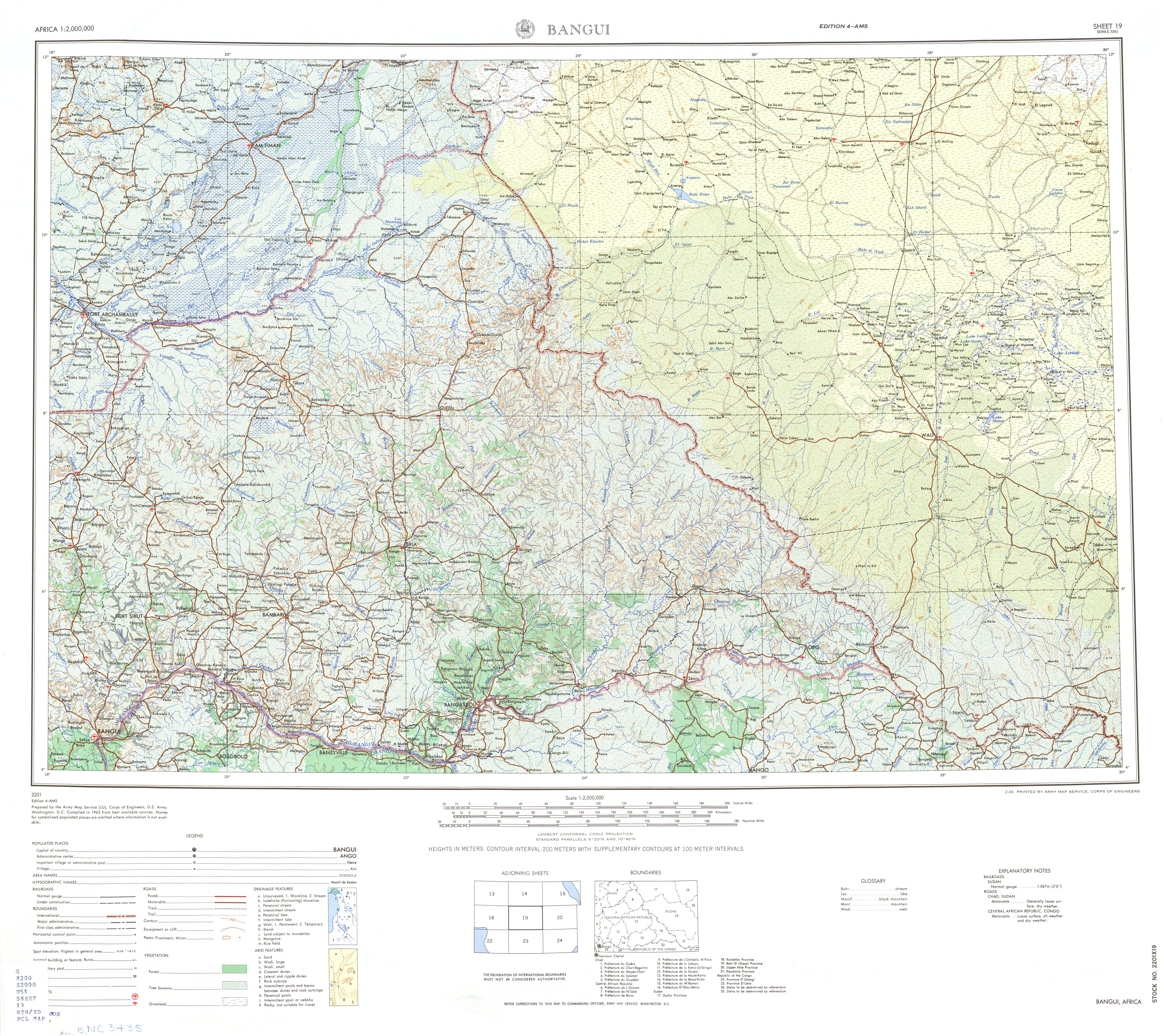
| Lost city in Darfur | There’s some place names in this map as well. http://www.lib.utexas.edu/maps/ams/africa/txu-oclc-6589746-sheet19-4th-ed.jpg but I think the towns may have changed names since then, Buram is on the map between 24 and 26 degrees in an upper quadrant. |
|
| Lost city in Darfur | It may be Gereida http://www.lib.utexas.edu/maps/africa/txu-oclc-224306541-sudan_darfur_2007.jpg The library of Texas has a huge map collection, http://www.lib.utexas.edu/maps/sudan.html some older maps and some US govt maps are public domain. |
|
| OSM so versatile. E.g. ski XC pistes are welcome | have you seen openpistemap? |
|
| Would there be any use for a builder=* tag? | Vancouver has a couple of reputable builders. |
|
| Opony goodride | polski spam |
|
| I think Lake Faguibine in Mali should be restored. | Thanks Jean-Marc. Google chrome has a translate option. it looks like it was well discussed. Take care. |
|
| Just started mapping actively in Brisbane - I have a few questions! | Adding an address node also preserves the address in case anyone decides to delete and retrace a big complicated building. |
|
| Just started mapping actively in Brisbane - I have a few questions! | for addresses, I usually see people add an address node separate from the building, so a coffee shop, bank and grocery store will have different addresses or unit numbers in an address. |
|
| Just started mapping actively in Brisbane - I have a few questions! | The name tag will be rendered. Sometimes when a building is built, it will have a name of it’s own, ie “Carlton Building” Example: The Vancouver Art Gallery is in the old provincial courthouse building. The addr:name is Vancouver Art Gallery the name attached to the building tag should match the building plaque on the building, but I’m sure that someone tagged the building name as Vancouver Art Gallery because that’s what we’ve locally known it as for decades. |
|
| On implied turn restrictions and armchair mapping | go to hell with your attitude |