
OpenStreetMap Belgium streetlevel imagery project
Posted by joost schouppe on 5 May 2022 in English.Opening up streetlevel imagery
With OpenStreetMap Belgium and our umbrella Open Knowledge Belgium, we have been lobbying to get governments to collect their street level imagery in the open.
While there are many projects to collect images, almost allways the government does not retain ownership of the imagery. Instead of paying for data collection, they pay for access to the data. This means the price is low for the individual governement organization, but in our complicated political landscape of federal, regional, provincial, intercommunal, or communal organizations, many are buying access individually. In the end, the total cost for the tax payer is higher, without there being any open products that can benefit the rest of society.
We believe payment for the data collection should happen only once, and ownership of the imagery should be transferred to the government. This would result in the lowest cost overal. By releasing the imagery as open data, its value for society is increased even more. Access to extra services can incentivise governements to pay up for the base data collection.
Slow progress
While the intercommunal organization WVI (Dutch text) has contributed open 360° imagery for most of the industrial areas in West-Flanders, and three Flemish municipalities have shared 360° imagery taken by Vansteelandt, the vast majority of projects that we hear about do not result in open data.
This is why in 2022 we are launching the Open StreetLevel Imagery Project. We are scaling up our efforts to crowdsource open street level imagery at a low cost. We are investing a very small budget which we expect to have a significant impact.
The OpenStreetMap Belgium role
Our members have been contributing millions of openly licensed street level images in Belgium already. We do this because it helps us build the map. OpenStreetMap Belgium wants to support these contributors and increase the quality of their work. Most of the images are taken with smartphones or action cameras. But in order to convince more people that this kind of platform is the right place for them to contribute, we are investing in 360° cameras.
The images aren’t just useful to local mappers. As we publish them on the Mapillary platform, they can be used by anyone in the business of producing open data. More than that, the platform automatically generates derived data about traffic signs and infrastructure, which is in turn available as open data. As we retain full ownership of the images, we can also share them under other licenses and on other platforms. For example, we are looking into transfering the images to KartaView as well.
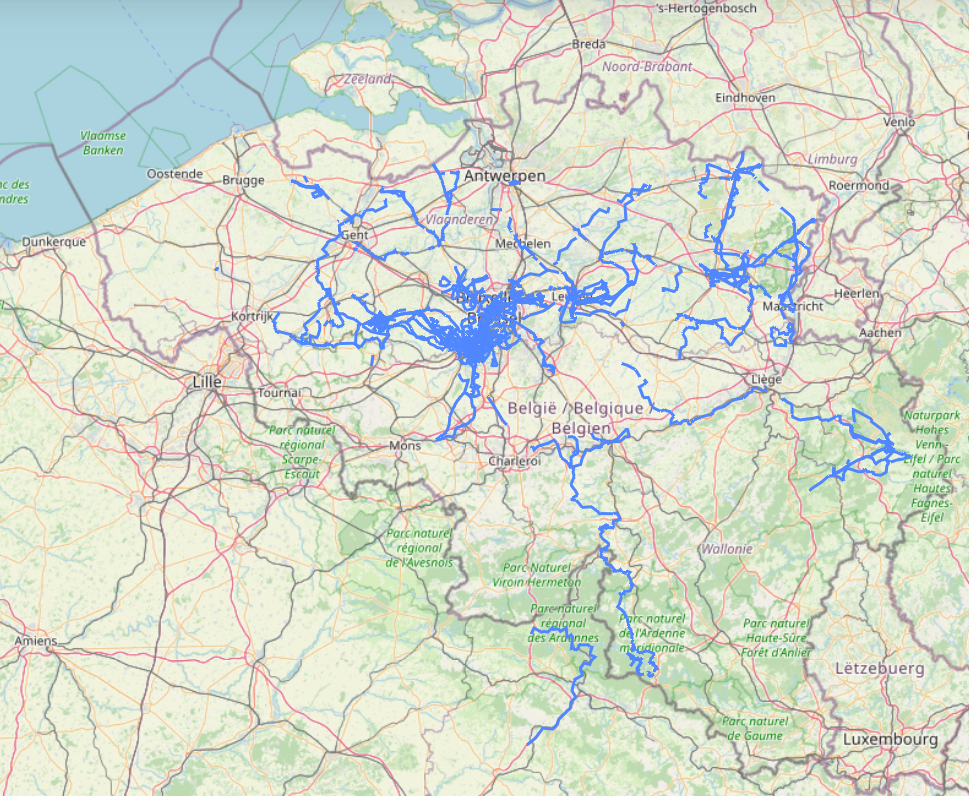 * Map of coverage from OSMbe members with their own gear and coverage with OSMbe gear
Crowdsourcing for the win
The crowd is more than just regular people. As the project grows, professionals start to use it, and start contributing. Open StreetLevel Imagery project contributors are also companies and governement organizations. The reasons are simple:
- It’s low cost. Since it takes no special skills to collect the imagery, you can work with volunteers or people who have to travel around anyway. Uploading is also quite easy
- It’s fast. Define a need today, grab your camera, and have the results available by the evening. Between large projects, ad-hoc work can fill the gap.
- It has unexpected benefits. You get derived data for free, can download the censored images for re-use, and your local OpenStreetMap data might get better faster.
While the low cost solution cannot offer the same benefits that advanced mobile mapping has, it can fill the gaps quite easily - possibly allowing you to leave more time between professional runs.
How can I contribute?
Thanks for asking! For our local audience:
- We’re always looking for volunteers who want to use the cameras. You don’t need to be crazy ambitious, but of course the cameras will go to people who can do most work first.
- Do you think there’s potential in your organization? We can set up a demo together and lend you a camera and accessories for testing purposes
- Do you have a use case for derived data? We can help set you up with the data and the tools.
- Would you like to see your local area mapped first? We can help you reach out to your network to find volunteers, and support them to collect the data.
- Want to see the project grow? Give us an earmarked donation and we will invest it in the project.
Internationally, we are simply looking for advice and exchange of experience. Ideally, we could just dump the images in a central repository and service providers can use them to create value. Right now we are building a simple backup solution for the images we took ourselves, so if this gets built, we can simply transfer everything we have collected.
Key events
- Early 2019. Work starts with a GoPro Hero 7 donated by Mapillary. Intensive use by contributor polyglot (many proposed cycle highways in Flanders get mapped) and Joost Schouppe
- Late 2019. As the Digitaal Vlaanderen “Mobile Mapping” project is stopped, we advocate for an open replacement.
- June 2020. The originally European open street level imagery company gets bought up by Facebook, as part of their OpenStreetMap centered maps strategy. Some context. This brings a lot of debate in the OSM community; temporary technical issues; and medium term stability.
- November 2020. OpenStreetCam becomes KartaView. Images from Mapillary can be automatically transfered to this similar platform, operated by Grab, a South-East Asian taxi company that contributes to and makes use of OpenStreetMap data.
- November 2021. The OSM Belgium membership decides to invest in 360 cameras.
- February 2022. The first camera is bought and gets heavy use in Lierde and Pepingen, by Dirk Dedoncker, a mobility consultant.
- March 2022. The camera goes to Saint-Georges-Sur-Meuse, where Pierre Serpe will use it for a project with the Gracq.
- March 2022. As the first camera is in heavy use, we receive an earmarked donation for a second camera. This camera goes to Westtoer, for experimental use in preparation of new cycle routes.
Note
This is a slightly rewritten version of the project page at OSM.be . You can read the full version there, in English, French and Dutch. OSM.be is geared towards explaining our projects to both mappers and outsiders.
Discussion