
On this day last year I announced the Imagery Offset Database: a centralized storage for imagery offsets. It was planned as a way to provide every mapper, especially beginners, with a confidence that they are tracing correctly aligned imagery. And for those not knowing imagery can be misaligned, a way to not ruin a map. After the announce, tens of mappers started entering their offsets into the database, and I’ve never made a local offset bookmark ever since.
Aerial Imagery cannot be ideally georeferenced. Depending on precision of your measurement tools (GPX traces give 1 to 10 meter precision), you may notice that the imagery layer is positioned incorrectly, and use your editor’s controls to shift it to the right place, so GPS traces follow roads and paths on the imagery. This is common knowledge among experienced mappers, and I hope beginner mappers learn that soon enough.
Sadly, looking at new editors I can’t but conclude than either there is no misaligned imagery (which is probably false), or many mappers, including those who work on those editors, don’t bother with aligning imagery to GPS traces. How many of you pressed those little arrows for shifting a background layer in iD editor? Does your favourite mobile editor, with which you upload POI nodes to the database, account for shifted imagery? Do you make bookmarks of such offsets so you can quickly restore them later, or on a different computer?
A week ago Simon Poole added IODB support to Vespucci, making it the second editor supporting it. This is great news, number of editors supporting the database has doubled overnight. Support in iD has been stalled, and I didn’t expect Potlatch or iOS apps to support it. So basically, pay attention and don’t be suprised when buildings are misaligned with imagery.
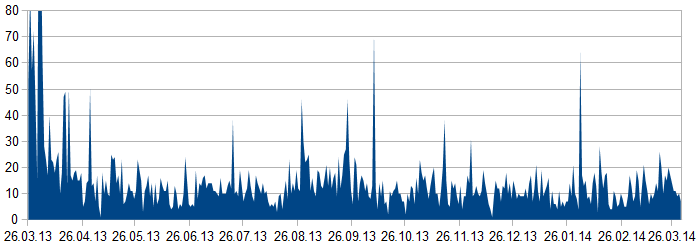
Now some statistics. As of now, there are 5180 non-deprecated entries in the database, of which 4078 (70%) are in ex-USSR countries (3180 in Russia). Mappers add on average 14 entries a day and have not skipped a day yet (see the graph above).
Of 5644 imagery offsets 4606 (82%) are of Bing layer, 714 of Russian and Ukrainian regional imagery, and around 150 offsets refer to some HOT-related imagery. Strangely, there are 44 offset of Google Maps, and 30 — of Yandex’s. I assume those users were just testing the database and not uploading anything to OpenStreetMap.
I hope someday we won’t need that database, but for now, when only a handful of coutries have precisely aligned imagery, it is one of the most important tools for mappers. It will probably be included in JOSM core later this year, and I’d be glad to hear of more editors supporting it.
And by the way, I always planned to publish the server’s source code, but got to it only recently: see it on github.
Discussion
Comment from RobJN on 31 March 2014 at 20:05
Good work. I’ve got so used to having aerial imagery available, but if that’s not well aligned then the OSM data may be entered with a misalignment.
Lots of places could do with more GPS traces (particularly on side streets). There’s not much you can do about that - perhaps we could look at using OpenData as a reliable source calculate the imagery offset?
Regards, Rob
p.s. I think the wiki page could do with being a lot shorter. I’ve found that short quick reference pages with the detail available on sub-pages is best. Let me know if you want me to have a go at doing this (on my User page until you’re happy with it).
Comment from Zverik on 31 March 2014 at 20:12
I know the page is too long — try this illustrated tutorial.
Comment from jaakkoh on 2 April 2014 at 19:19
Hi Zverik,
Big thanks for the IODB! It came in perfect time last year for the HOT mapping project in Northern Haiti and helped significantly improve our data quality in terms of alignment issues.
Regarding the Google imagery offsets. Where are they? I think I’ve at least created some for Haiti for areas that we (still) have access to the allowed 2010 post quake imagery. Maybe that explains it? .. Given that this is a JOSM plugin I don’t even know who you could get Google imagery to show up in JOSM.
Thanks and keep up the good work!
Comment from tmcw on 8 July 2014 at 19:04
To be clear: we’d be happy to accept a pull request that adds support to iD, as stated in June of 2013. Nobody has stepped forward with code to do that, so it hasn’t happened. Anyone who can write it and submit a pull request can make it happen today.