
* So that is what inaccessible road is!
Posted by Zkir on 19 October 2012 in English. Last updated on 20 October 2012.The essential condition for a map, to be used in routing, is integrity of the road network. Ideally, there should be a single [strongly connected component] (http://www.openstreetmap.org/user/DennisL/diary/17853). All edges of the road network should be accessible for routing.
Unfortunately, there are currently 1,000,000+ inaccessible edges (road segments) in OSM data. It looks that fixing them all will be hard toil.
Here is a small tool that can make this task easier:
http://peirce.gis-lab.ru/fixme
It works in a very simple way: it displays one of the inaccessible road segments found by OSRM test, and loads it automatically into JOSM for editing.
Currently, inaccessible edges from selected areas (Poland, Finland, European part of Russia, Thailand and Japan) are suggested for fixing. In the near future it will be extended to the whole world.
The utility has user interface in English and Russian, other languages can be added if somebody helps me with translation.
Also, there is a description of the most typical situations: http://wiki.openstreetmap.org/wiki/So_that_is_what_inaccessible_road_is! and suggestions how to fix them.
Upd:
Inaccessible roads in Thailand
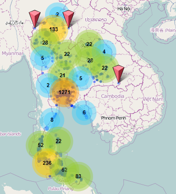
Visualized a bit differently from OSRM Small Components layer, the components are clustered.
Discussion
Comment from Zverik on 19 October 2012 at 17:57
Needs a pic to gather attention :)
Comment from Zkir on 19 October 2012 at 18:46
2Zverik You are absolutely right. Better to add a photo of naked girl-cartographer, but we still do not have any software to find them, you know.
Comment from Willi2006 on 20 October 2012 at 10:20
I think it’s irresponsible or even arrogant to point remote armchair mappers to another country without contacting the local community first and not giving some guidance which is already available in
Beginners Guide item 3. http://wiki.openstreetmap.org/wiki/Beginners_Guide_1.1
Community Code of Conduct http://wiki.openstreetmap.org/wiki/Community_Code_of_Conduct_%28Draft%29
Disputes http://wiki.openstreetmap.org/wiki/Disputes
Comment from Zkir on 20 October 2012 at 13:09
Willi2006, I agree with you, but I see no actual problem.
Comment from dkiselev on 20 October 2012 at 17:44
Willi what difference between:
Surface is the same, so it’s not a main classification sign. Isn’t it? So what is the main base for classification between unclassified track?
Comment from Willi2006 on 22 October 2012 at 14:19
Well I surely can’t and won’t represent the Thai community. There’s a Thai forum where you posted already http://forum.openstreetmap.org/viewforum.php?id=46.
Comment from Willi2006 on 22 October 2012 at 14:54
Classifying a highway, e.g. as unclassified or track, is according to its importance in the grid of highways. It’s independent of the highway characteristics or quality which is mapped with other tags like surface, smoothness, tracktype or width. See also “What are the most common mapping mistakes that other users make?” https://help.openstreetmap.org/questions/1022/what-are-the-most-common-mapping-mistakes-that-other-users-make
The purpose of unclassified highways is to drive to, from and through villages. The purpose of residential is to drive within a village, town or settlement. The purpose of tracks is primarily agriculture including forest and similar activities. In some countries tracks are usually restricted (access=*) for other vehicles in others not. In experienced it as quite easy looking at aerial images, building the grid of the highways in my head and to distinguish these 3 types. Easier than on the ground.
The physical characteristics of highways can vary enormous even in the same country. An unclassified highway can be oneway=yes, surface=asphalt, lanes=4, smoothness=excellent in big metropolitan areas like Bangkok or surface=sand, width=4 smoothness=bad in a rural area. And a track can be surface=asphalt, smoothness=excellent width=4 but also surface=ground, smoothness=horrible, width=2, i.e. passable with tractors only.
These examples should make it clear that it’s not possible to deduce the classification from the physical characteristics.
Comment from Zkir on 22 October 2012 at 20:12
Willi, btw, are road statuses set correctly here in your opinion?
To get to the buddhist shrine on have to drive tertiary-track-service.
Should not this track be unclassified instead?
Comment from Zkir on 22 October 2012 at 21:43
Another place http://www.openstreetmap.org/browse/way/146447924 - do you agree that hw=track is unappropriate here? Should be hw=tertiary+surface=unpaved, should not it?
Comment from Willi2006 on 24 October 2012 at 10:24
Zkir wrote: “Willi, btw, are road statuses set correctly here in your opinion?”
Short answer: Yes, they are. I did it. And I did already hundreds. ;)
Long answer:
The “Thai temples” are called in English “wat”. A wat is a monastery, an area where monks live, pray and work. It’s not just one or more buildings. More see wikipedia.
I understand the current issue is that osrm rejects highway=service branching from highway=track. But this restriction doesn’t implement the reality in Thailand. Let’s assume I’ve mapped a track which is many kilometers long. Now someone builds a house to live there close to the end of the track. Or a hermit builds a hut there. There’s no settlement, no hamlet. There’s only one building. In Thailand you can do that. Should the track now be changed to unclassified. I don’t think so.
In addition I never saw or heard that the access to tracks is restricted in Thailand. And Thailand with 60 million inhabitants is the second largest market for pickup trucks behind the United States with 300 million inhabitants. Thus everybody can and many do use tracks as shortcut between villages. I think no reason to tag them all as unclassified.
Comment from Willi2006 on 24 October 2012 at 11:44
Zkir wrote: “Another place http://www.openstreetmap.org/browse/way/146447924 - do you agree that hw=track is unappropriate here? Should be hw=tertiary+surface=unpaved, should not it?”
Short answer: Yes, of course I agree. It must be wrong. It’s not mine ;)
Long answer:
I think not necessary to explain. I think we agree on the reasons. In addition according to general and country rules only a highway with ref can be tertiary. I guess it’s mapped according to physical characteristics not according to the grid or graph as you would call it. I must admit, not so extreme but I made this error also when starting. Luckily I was able to learn fast to separate classification and physical characteristics and fixed my errors myself. But there might still be one left.
Another example: A way is tagged highway=tertiary (oneway=no) outside villages but tagged as highway=residential within a village. I saw also a tertiary tagged as highway=trunk within a village because it’s a dual carriage way (oneway=yes).
But what to do when you find such obvious errors. Just changing is imho a bad idea. We are a community and this might hurt someone for different reasons. Have a look at Beginners Guide item 3..
Usually I look up who did it and when. I try to get a “profile” of the person. Is the person a beginner with just a few changesets or an advanced with 1000 or even more changesets? Is the person mapping local or remote? Has the person local knowledge? Does the person stick to an area or is the person a vagabond?
When the person seems to be a beginner I watch him for a while. Is the person learning? I send an e-mail, say hello, there are others too, there’s a Thailand page, several international and a Thailand forum in case you want ask something. Of course this takes time. But it’s worth to do that. Thailand desperately needs local mappers preferable with Thai skill. Look at this list ODbL in Thailand.
When the person is the opposite, clearly an advanced, a remote armchair mapper and a vagabond I don’t want to spend much time because I prefer mapping. In addition when the person is changing my tagging without contacting me beforehand I’m rather bold in my writing. This is topped when dozens of them appear in the same time frame. :)
Comment from kay_D on 13 November 2012 at 09:11
Problem with road areas
Just tried it with my neighborhood, and first match was a wrong positive, I believe:
http://www.openstreetmap.org/browse/way/38963176
is reported as inaccessible, but is connected via
http://www.openstreetmap.org/browse/way/38963179
which, admittedly, is a highway area. Is it possible that the router ignores highway areas?
In all other respects a very nice and handy tool, but with Opera (V12), it does not automatically load the area into JOSM, but I have to click on the link, which is not really an issue.
Comment from malenki on 25 December 2012 at 08:47
SInce several days http://peirce.gis-lab.ru/fixme doesn’t work.