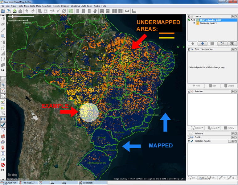
TMS layer of Comparative Map of Brazilian Roads (IBGE x OSM)
Posted by smaprs on 3 September 2016 in English.Purpose: to help on easy identification and zooming in undermapped areas, mainly for roads still missing on OSM map, on basis of IBGE data (Brazilian Institute of Geography and Statistics - Data publicly available according to legal statements).
Documented at (in portuguese): “Situação do Mapeamento de Estradas no Brasil”.
Feeling the lack of some data that could easy identify and help to improve on basic mapping in undermapped areas of Brazil, regarding accessibility, I’ve firstly decided to try to do a single georeferenced PNG image showing where there could be these areas, generated with QGis to use in JOSM with Piclayer plugin. Then tried a TMS layer.
Our community keeps doing great efforts on mapping. Mostly metropolitan and urban areas are well mapped for general accesibility.
Also are rural and inner country roads linking main urban zones.
Many data recently delivered for legal public use by IBGE is helping on the mapping on OSM.
These data lead to identify many other roads that area still missing on OSM.
Almost no data from GPS layers in the huge areas of inner country, as expected too.
So I’ve started trying to do a map that could help to identify roads from IBGE that are missing in OSM.
These two sources of data were used on this Comparative Map:
* roads from the .shp of IBGE (compiled untill 2015);
* roads from the current state of OSM map (2nd half of 2016), obtained from geofabrik.de (file “roads.shp”).
The methodology adopted was as simple as I could attempt to do in QGIS: just overlaying IBGE ways (in orange and yellow) with OSM ways (in dark blue), so to highlight IBGE roads, no need for overlapping analysis. Just colors:
Zoom 5: Identifying and zooming in to undermapped areas (next example highlighted)

I’ve started to generate this map in TMS tiles, with transparent background, using QTiles plugin in QGis, with precious technical help from [user:naoliv] (@naoliv). Decided to do it from zoom 3 to 9: it took 5 hours of processing and 110MB to generate 4850 TMS tiles in PNG 256px. [User:wille] (@wille) is helping hosting the 110MB tiles on his server, and many others are helping on improvements and using the TMS layer to map. Maybe another day I’ll generate zoom 10, it’s expected it’ll take around 20 hours and 400MB. Further zooms would take additional 4x time and size each zoom, so up to 80 hours and almost 2GB if zoom 11, with only 2x gain in resolution from 10 to 11. The aim was to help on identifying location of official roads still not mapped. It was achieved, so that’s enough for now. From zoom 9 to closer zooms the purpose is, as expected, to trace the identifyied missing roads from hi-res satellite imagery.
Zoom 9: road labels and zoom limit

Zoom 11 and 14: road detected in hi-res image to map in closer zooms

So now we have another tool to help on improving road mapping in Brazil. We expect to update this TMS layer as the road mapping increases, perhaps once a year.
This TMS layer “Comparative Map of Brazilian Roads (IBGE x OSM)” is available here:
http://tms.openstreetmap.com.br/ibgeXosm/{z}/{x}/{-y}.png

Discussion