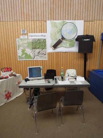
5th Adventure Days in Glauchau
Posted by malenki on 12 March 2015 in English. Last updated on 13 December 2015.At the AbenteuerTage (Adventure Days, a festival where adventurers present their travels) two years ago in exchange for hosting a GPS Workshop I was allowed to represent OpenStreetMap. Last year Gil Bretschneider, operator of the festival, invited me again to have an OSM booth at the festival last weekend. Happily I agreed, although I partly broke my right arm shortly before the beginning.
Again the festival was well organised, everything ran smoothly. Of course one could also meet interesting people when not being at the OSM booth. :)
This time I was so bold to visit one of the presentations of a family with two girls of now eight and four which had travelled Mongolia during three years for about ten months with camels. Although I am of course fascinated by this kind of reports I’d prefer not to listen to the traveller but instead do the travelling on my own.
My personal highlight was Heinz Stücke. This German travelled the world for more then 50 years and nearly 650,000 km. The biggest part of the distance he went with a three-gear-bicycle. More details are to be found on Wikipedia. I also added some pictures with his allowance to Wikimedia Commons.
Now from travel statistics to the ones of the OSM booth:
One visitor mourned about the bad quality of OSM data in remote regions like Guatemala and Indonesia which I believed without research because of the small number of active mappers in less developed countries. Over the incomplete incomplete Panamerican Highway I had stumbled when testing long distance routing
Two visitors praised the good quality of OSM data in remote regions. One of them was the man whom I equipped with OSM based maps for his Garmin device at the 4th Abenteuertage two years ago. Three or four visitors installed OSMAnd, one even purchased the app after short testing. He also took the whole world in OSMAnd maps which I had with me – 55 GB.
Another four visitors we could give OSM maps for Garmin devices. Amongst them was a man who travels by kayak a lot – he was happy to receive the Mediterranean Sea and the north of Europe. I also asked the visitors to donate data back to OSM, at least to upload their collected GPS data to OSM – or email them to me.
This time we weren’t able to establish an internet connection so we couldn’t edit OSM on site but I mad a todo list of things to add/fix visitors told me.
OSM-Flyer and a HowTo sheet for installing OSM based maps on Garmin devices were of interest to a lot of the visitors.
Of the µSD memory cards I brought with me just in case I sold the half (1x 4GB and 1x 8GB) for the net cost, the maps were free of course. Also two OSM stickers got purchased.
Several visitors were quite interested for the idea behind mapillary.
Last but not least I could infect some of the visitors with my Albanophilia [de] so I assume that there will be some more people to travel Albania soon.
Walking to my room and back I travelled 10,5 km and collected 33 waypoints for corrections and additions at OSM.
For the success of this weekend I want to thank:
- firstly Gil Bretschneider from grenzenlos-expeditionen for the invitation
- my mother for transportation and helping erect the booth
- Rockus for his presence during the three days all the time
- Frederik Ramm from the Geofabrik for the posters
- mapillary for stickers and T-Shirts
- all visitors for all the interesting conversations
PS: I forgot the donation of 1,50 EUR for OSM by a visitor. The amount I just transferred to OSM.


.jpg/640px-Heinz_Stücke_03_(Glauchau_2015).jpg)
Discussion