
Why use OpenStreetMap instead of Google Maps ?
Posted by jbelien on 14 July 2018 in English. Last updated on 15 July 2018.Cet article est également disponible en français : osm.org/user/jbelien/diary/44358
Article written for open Summer of code 2018
First of all, there is absolutely not doubt about the fact Google Maps is a good product and the Google Maps tools (API, JavaScript library, …) work quite well and are easy to setup but …
Google is in charge
When Google Maps started more than 10 years ago, everything was completely free to use. These last few months that has changed drastically.
The first decision made by Google was to limit the free number of requests per day. It didn’t really impact the small users that were still under the limit but some big players decided to switch to other solution like OpenStreetMap (for instance Foursquare and Pinterest).
The latest change (June 2018) has much more impact : Google decided to reduce the limit of free requests (25000 map display per day to 28000 per month - that’s around 1000 map display per day, so 25 times less) but also made it mandatory to give your credit card number even if you do not go over the free limit !
Impact on Belgian Prime Minister website :
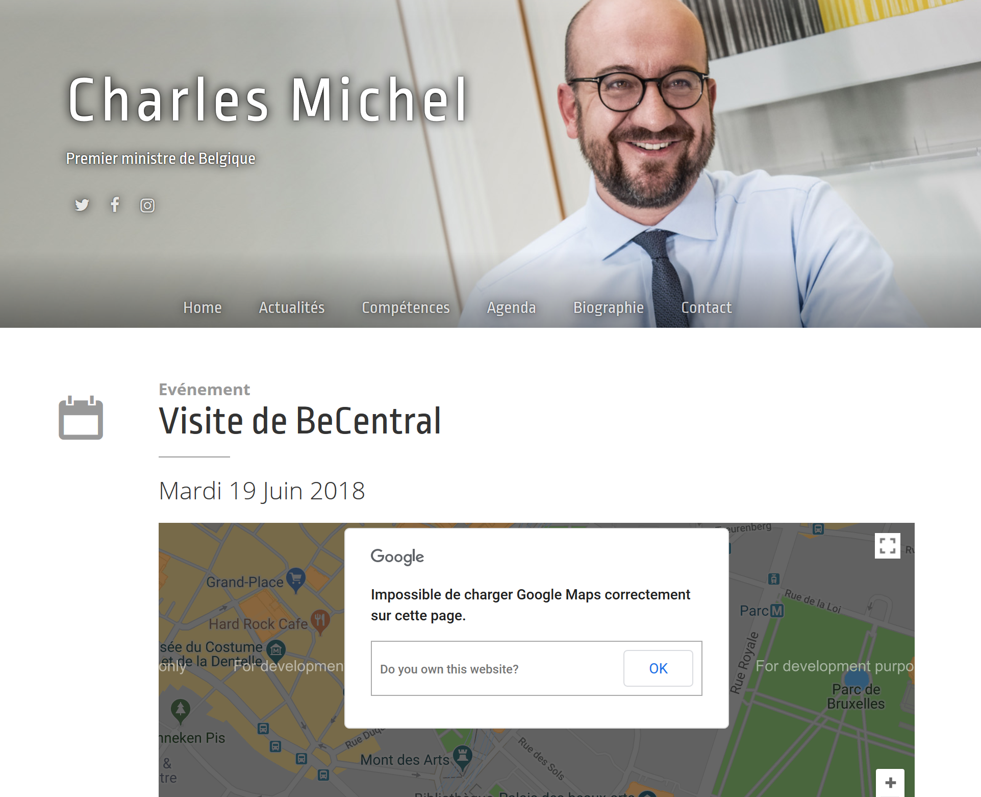
Money is definitely an issue but worst, Google can decide what’s displayed or hidden or highlighted and how it is displayed. What if Google decide to “hide” or “highlight” certain kind of shops for instance ; even worse, what if they decide to draw the border between countries wherever they want. All of this could quickly lead to ethical issues !
Long story short, you have absolutely no control about this, Google can change the term of use of their service when they want how they want and it will most probably not be in your advantage !
Why OpenStreetMap ?
OpenStreetMap is a free, editable map of the whole world that is being built by volunteers largely from scratch and released with an open-content license.
The OpenStreetMap License allows free (or almost free) access to our map images and all of our underlying map data. The project aims to promote new and interesting uses of this data.
– Source: https://wiki.openstreetmap.org/wiki/About_OpenStreetMap
OpenStreetMap use is free as in free beer but also as in free speech !
Everyone can contribute and everyone can use it ! OpenStreetMap is open data !
Whether you’re a developer, a scientist, an activist, a cartographer, …, you can use OpenStreetMap database to fulfil your need.
You have access to the data
Google Maps doesn’t give you access to the data behind the map (and that’s the case for most proprietary solutions) but you have full access to the OpenStreetMap database !
Access to the data means you can build a map that suits you and not depend on decisions made by the map provider.
If you need some information, just download it ! Let’s say you need all the buildings from Brussels for a research project, or you want to find the nearest ATM, or you want all the information from the country you’re in vacation and you need it offline, … ; those are all simple queries ! OpenStreetMap database is open !
OpenStreetMap covers the whole world with the same mapping rules so it’s really easy to switch from local to global !
If you see that something is wrong in the map, just fix it, or notify the community and we’ll fix it ! Fixing the map will not only benefit one big player but everyone in the world. OpenStreetMap is made by citizens just like you.
Power of the community
Thanks to hundreds of thousand contributors all over the world OpenStreetMap is probably the most up-to-date and complete map of the world.
When the city center of Brussels became officially accessible for pedestrian only, the update was immediately made in OpenStreetMap the day it became official ; same thing for the recent mobility changes in Ghent. Google Maps of course also made the change but it took a few weeks, sometimes months … and that can lead to some issues (navigation, …).
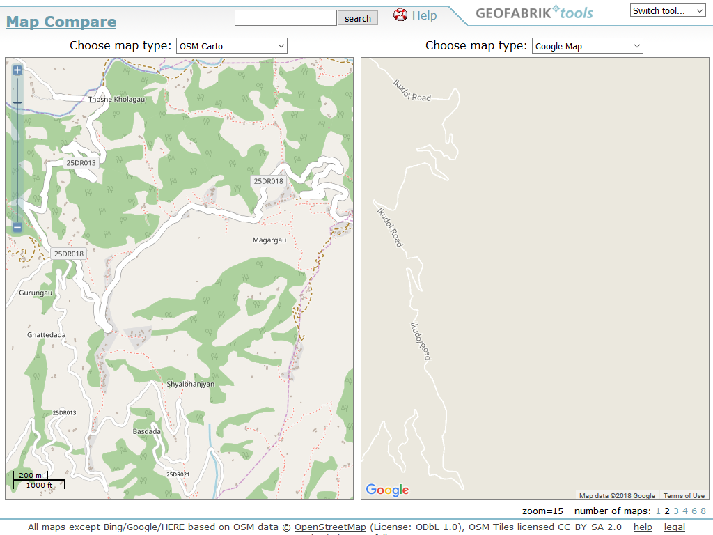
Third world countries are also a great example of the power of the community : humanitarian organization (like Doctors Without Borders, Red Cross, …) often need maps to be able to prepare and coordinate their actions on the field. It usually costs a lot to buy maps from those regions (if there is a map available) so they made the switch to OpenStreetMap. They call us on a regular basis to ask the community to map part of the world where they have to take actions.
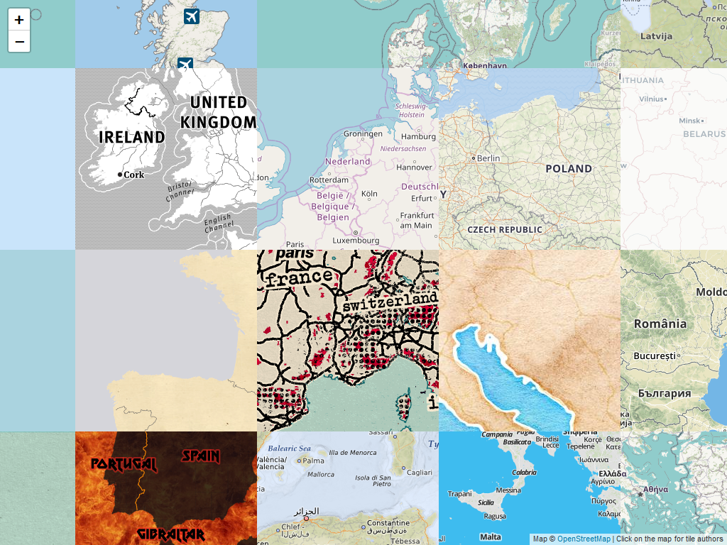
Example of difference between OpenStreetMap and Google Maps in Kathmandu :
That’s nice but let’s get technical …
Many libraries and tools are already using OpenStreetMap data.
You’re looking for a baselayer, there are so much options available depending on your needs (standard basemap, basemap focused on cycling, on accessibility, …). Have a look at the list available on the wiki : osm.wiki/Tiles#Servers and if you want to play with Vector Tiles, have a look at https://openmaptiles.org/.
OpenStreetMap Belgium also provides its own baselayers covering Belgium and surroundings : https://tile.osm.be/.
You’re looking for a geocoding API, have a look at Nominatim : https://nominatim.openstreetmap.org/.
You’re looking for a routing algorithm, check OSRM (http://project-osrm.org/), GraphHopper (https://www.graphhopper.com/), Itinero (http://www.itinero.tech/), …
Everything that’s possible with Google Maps is possible with OpenStreetMap and (almost) as easy to use and set up !
You can find more information on https://switch2osm.org/ !
You can also have a look at all the great libraries made by Mapbox : https://www.mapbox.com/help/how-web-apps-work/
That’s probably the easiest way to switch from Google Maps to OpenStreetMap : Mapbox libraries and API allow you to have all the function provided by Google Maps (basemap - you can even style your own -, directions, geocoding, …) and are all based on OpenStreetMap data. Most of Mapbox products are open-source but some services and functions come with a downside, you’ll have to pay if you go over the request limits.
Some more reading (and sources used for this article) :
In English:
- https://switch2osm.org/why-switch/
- osm.wiki/Why_OpenStreetMap%3F
- http://geoawesomeness.com/why-would-you-use-openstreetmap-if-there-is-google-maps/ (by A. Buczkowski)
- https://www.citylab.com/design/2016/08/google-maps-areas-of-interest/493670/ (by L. Bliss)
In French :
- https://medium.com/@cq94/dont-be-evil-until-95f2e8dfaaad (by C. Quest from OpenStreetMap France)
- https://medium.com/@cq94/tarifs-google-maps-pour-les-nuls-d47c1833c242 (by C. Quest from OpenStreetMap France)
Discussion
Comment from Antwelm on 15 July 2018 at 11:51
Nice writeup. Thanks.
Comment from dikkeknodel on 21 July 2018 at 16:20
Very cool picture to show some of the map possibilities! And a great write-up off course.
New to me is the map compare from Geofabrik. I had a look in my surrounding and had a serious laugh about how poor HERE and GOOGLE do in mapping the Swiss outdoors compared to our beloved OpenStreetMap.
Comment from jbelien on 12 February 2019 at 08:37
Awesome ! Thanks se7entime ! :)