
Urban Aerial Imagery Collection and Other Things
Posted by geoleighyers on 6 November 2019 in English. Last updated on 7 November 2019.An awesome group of OpenStreetMap PH volunteers and drone enthusiasts visited Lupang Arenda in Taytay, Rizal to collect aerial and street-view imagery. With the help of Barangay Sta Ana officers, we were able to conduct the survey smoothly. I was part of the drone team and our goal was to provide high-resolution imagery for mapping buildings, roads and other attributes using OSM.
As my first urban aerial imagery collection experience, it was a trial by fire. I used to have that confidence with my skills but those unpredictable factors and unpreparedness made me question my skills as a drone pilot. It was challenging but at the end of two days, the images were collected, the high-resolution orthophoto, digital elevation models were produced and I learned to be prepared even in unpredictable times.
July 7 Fieldwork:
 Team photos from @GOwin
- I did no pre-flight checklists except charge the batteries and identify take off points because I was complacent. So, as expected, I had a hard time with almost everything.
- I used Pix4D mapper to create the flight plan and fly the drone. A few minutes after take off, the controller was disconnected from the drone itself! Good thing is that I have a very reliable spotter with me to check if the drone is still flying. It was still flying the flight plan I loaded on the application. Other than my trusted spotter, there’s no way for me to identify the drone's location and I can’t control it to return home. I was in a state of panic and had to call the other team to ask for advice. They said to wait it out it will surely come back. But seriously, who can relax in these dark times?
- I was flying in an open space but it’s difficult to maintain a visual line of sight of the drone because of the buildings. Also probably decrease the connectivity between the drone and controller.
- After 15 minutes, lo and behold! The drone and the controller connected, I immediately pressed Return-To-Home (RTH) and retrieved the drone with only 30% battery left. No photos were taken. Worst 15-minutes of my life.
- Tried again twice using my spare two (2) batteries but it failed. It was only able to capture the images when the drone and the controller are connected.
- I was only able to take 16 photos in total. Hurraaay life!
- Actions / Steps to resolve the problem:Updated the drone to the latest software, read forums why it happens.
 Failedt Pix4D mission
October 12 Field Work
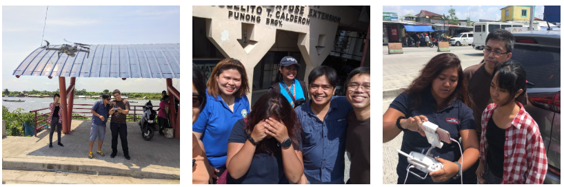 *Team photos taken by @maningsambale
- I was prepared and anticipated the loss of signal during flight. I was able to fly in Dumaguete with no problems months before this 2nd field work.
- Same thing happened. It disconnects immediately and continues following the flight plan.
- I modified Pix4D mapper settings so the drone can still take photos even without the drone-controller connection.
- This, however, affected the duration of each flight. Originally from three(3) flights to cover half of the area, I did more.
- A portion of the area was on a no fly zone. The flight was cancelled and RTH. Luckily, there is a good internet connection so I was able to unlock the drone I was using in under 10 mins.
- At 3:00pm, we finally covered all area!
There’s a gap in the upper-left portion of the image. It was because I couldn’t find the drone (VLOS is sooo bad) I had to abandon the mission.
 Taking photos like a baus! I used DJI Mavic Pro 2 for this and the drone-controller connectivity is sooooooooo good! Totally better than my experience using Phantom 4 Pro
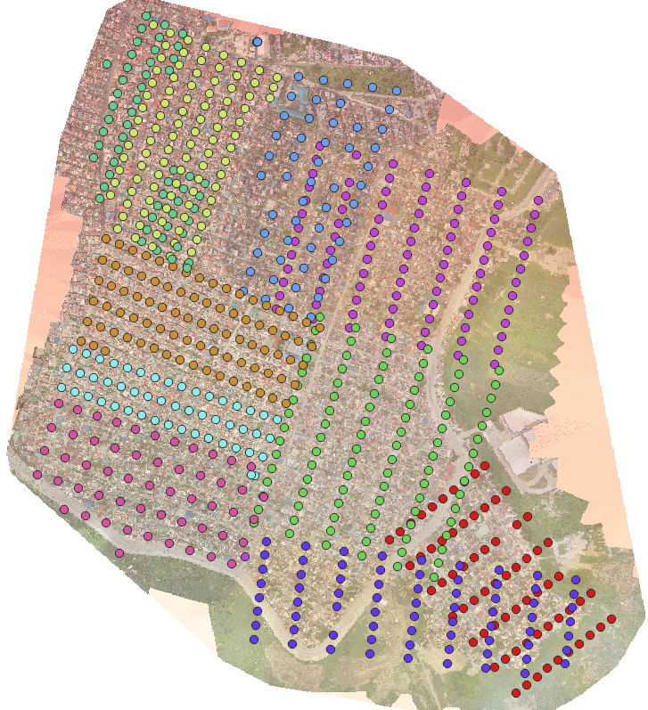 Total of ten (10) flights to cover LA
Lupang Arenda Team (LA TEAM)
Marianne Mampusti, Katherine Belano, Leigh Lunas, Erwin Olario, Maning Sambale, Rally De Leon, Banito Soriano and Ian Gongona
Drones:
DJI Phantom 4 Advanced, DJI Phantom 4 Pro, DJI Mavic Pro 2
Application:
DJI Go 4 and Pix4D Mapper
*My team (Rally and I) settings:
Drone Speed: Fast
Front/Side Overlap: 70%|70%
Picture Trigger Mode: Safe Mode
For more blog entries about this project, check out Sir Maning's post:
https://www.openstreetmap.org/user/maning/diary/390221
Thoughts? Comments and suggestions are highly appreciated! :D
Discussion
Comment from maning on 6 November 2019 at 09:22
Sa uulitin Leigh!
Comment from geoleighyers on 6 November 2019 at 09:58
Sa susunod ulit, Sir M! XD
Comment from OSMWeekly on 6 November 2019 at 17:05
really cool! Thank you for sharing.