OpenStreetMap

davidearl's Diary

Recent diary entries

Pilgrimage to Newlyn

Posted by davidearl on 1 August 2013 in English.

I visited the west of Cornwall for the first time in July. So I had to make a pilgramage to Newlyn (location). Newlyn is the Ordnance Datum for Great Britain, the zero height mark for the whole country. I thought there would at least be a plaque or notice, but no, there’s no indication at all. I had to ask in the harbourmaster’s office, where an archetypical gum-booted seaman told me that tourists often ask about it and he was surprised there was nothing to show for it. It is located at the end of the southern pier to the harbour, which is inaccessible; but I could get out to the end of the north pier opposite and take this photo.

Newlyn zero datum

I gather the red and white hut next to the harbour light houses equipment to support this, and you can see a cable leading from it down into the sea. The Ordnance Survey site suggests there is a marker bolt, but I can’t see it. It may be below the current sea level.

There needs to be an information board or something.

I also visited the Geevor tin mining Museum (location;website) where I thought the most interesting thing was a three dimensional map of the mine workings (along with neighbouring Levant mine):

Geevor workings

This was prepared in the 1960s, when the mine was in full swing, to show managers the extent of what was underground. The labels are essentially at ground level, which slopes moderately steeply down to the sea. The coastline can just be seen in the foreground drawn on the base, but sea level is where the blue tabs are. The workings extend a few hundred metres out under the sea, and the deepest are getting on for 500m below the surface.

I don’t know how you’d go about preparing a map like this accurately. Presumably laborious measurements with theodolites - difficult when some of the tunnels are so small you can barely squeeze through or stand up.

Location: Trevithal, Paul, Penzance, Cornwall, England, TR19 6UQ, United Kingdom

The University of Cambridge today launched its new responsive web site design, and its map, based on OSM and originally released last September, was part of this. My previous diary entries talk about the development of the map using OSM.

However, the map update was more than the design, and an API revision. It introduces a new facility to mark your own features in an overlay on top of the map. Want to let someone know where to meet? Or how to reach you from the station? Where will our new building be? Draw it on the map and send a link.

While the drawing facilities aren’t particularly novel - you can draw points (which can have text and an image linked to them), lines and areas, and style these - what makes it a bit different from some other map annotations is that there isn’t a database behind it. The editor creates (and edits) files, and the link you can send is a combination of two URLs. So it’s a bit like KML, though actually we chose a JSON format. But because you can put the file at any URL, they don’t have to be simple files generated by the editor: they can be scripted, so other formats and data sets can be overlaid (so KML or GPX or extracts from OSM XML files could be converted as an overlay on the fly, for example, though we haven’t done that yet).

For example, we can overlay the University data cabling network (called the Granta Backbone, comprising a hundred miles of ducting across the whole city and dozens of inspection chambers and terminal junctions) on the map, from a protected overlay (sorry, it is not public data, so I can’t show you this). Another overlay seeks out the college staircase entries from OSM data and creates dynamic overlays from these. It has also allowed us to translate links from the old University map (which were pixel offsets onto a set of fixed images).

A simple storage mechanism is available to University users, but anyone can use it if you have somewhere to put it: indeed Dropbox is such a place accessible to anyone: just share the overlay from Dropbox as a link. By not relying on a closed database, in principle where overlays are generated (whether interactively or programatically) is divorced from where they are used. Here’s an example: http://map.cam.ac.uk#http://www.frankieandshadow.com/tj/csf.json - note the links off the overlay.

The map is at http://map.cam.ac.uk (and linked from the About the University link on the home page www.cam.ac.uk). ‘Annotate the map’ on the More menu takes you to the editor, which is http://map.cam.ac.uk/overlay

Most of the code is Javascript, and in two separate chunks, one for overlaying the data on a map, and the other to edit it. It only has loose ties to the underlying map tiles: the calling map supplies some functions to say where to put the new graphics, and how to tie lat/lon to pixel offsets. So in principle, it can work with OpenLayers or leaflet with minor changes, though the University map is neither of these. It would be fairly easy, for example, to allow the OSM home page to apply such overlays, edited elsewhere. The libraries are fundamentally reliant on jQuery though.

In the University Map, the drawing is done through the Raphael JS cross browser graphics library, though it only uses a tiny part of it - basically move, line and close path, and colours, widths etc of those. But it doesn’t have to - SVG could be generated directly, but I didn’t do that because I’d have had to do it differently for IE.

Though the University has financed its development for its own use, The code will be licensed GPL, so it should be both technically and legally possible to use it elsewhere. There’s a lot more info on the format used and so on from the help pages and links above.

University of Cambridge map now live

Posted by davidearl on 2 October 2012 in English. Last updated on 3 October 2012.

I am pleased to say that the University of Cambridge’s new online map is now live, at http://map.cam.ac.uk , and linked off the University’s home page at http://www.cam.ac.uk .

This is the outcome of Project Drake, started a year ago. Surveys were conducted, with the data going into OSM. The data is rendered to a custom style loosely based on a previous non-OSM one. There is a database of the OSM data to support street name and third-party location searches and a database of institutional contact details. The two are loosely linked using the ref tag so that the university database can determine where an institution is located geographically. There is an API; and a separate presentation on small screen devices.

A paper map is also in final draft form.

There is some background the project here: http://www.openstreetmap.org/user/davidearl/diary/15398 and here: http://www.openstreetmap.org/user/davidearl/diary/17050

The University’s Computing Service has published a news release, here: http://ucsnews.csx.cam.ac.uk/articles/2012/09/24/new-university-map-launched

University of Cambridge map

The University is intending to redesign its web pages from the end of the year, so the styling will change again before long.

Update on Project Drake, mapping the University of Cambridge

Posted by davidearl on 10 June 2012 in English. Last updated on 28 December 2012.

Back in December I blogged about Project Drake, to map the University of Cambridge. Surveying for this has proceeded steadily over the last eight months (April was somewhat wet, as you know, but apart from that all went pretty smoothly). With the recent upload of data for Trinity Hall, Trinity College and their outliers, it is now essentially complete: 31 colleges, ~10 campus-like sites, several thousand buildings.

The Colleges, which are all independent of the University, and Addenbrooke’s Hospital where several University departments are based and more properly now known as the Cambridge Biomedical Campus, have all kindly co-operated in allowing access for surveying, and the University has provided most of the survey data to OSM so it is both a provider and consumer of data. The software will be released under GPL shortly.

I am currently putting the finishing touches to a custom rendering (which goes down to zoom 19, about 1:1,500 on a typical monitor with 45m map tiles, but just for the University area, about 8 square kilometres) using its existing map style as a starting point. These are provided via a slippy map, an API (JSON) and iframe embedding for third-party sites, a dynamic search index, and artwork for a paper map (at 1:7,500). The website isn’t publicly available yet, but we have http://map.cam.ac.uk reserved for it. We hope there will be a “productisation” phase next (the current exercise is formally a “feasability study”).

As well as all the University and College buildings, though you can’t see it on the Mapnik rendering, we also have (E&OE) all the cycle parking, disabled parking, building entrances and site entrances. The quality of the data before I started varied considerably from college to college and site to site, varying from nothing at all for the Silver Street/Mill Lane site to a beautifully mapped Wychfield (part of Trinity Hall). However, even for the previously best mapped areas, I’ve improved lawns, gardens and paths, added entrances and generally made everything more consistent and rectilinear.

In particular, there is a comprehensive building and site reference ID scheme (based on the University Estates Department’s internal numbering). This allows us to link up the index with with the geographical data from OSM, including at the level of entrances.

On the whole, the tagging scheme I set up at the beginning has proved robust. There are some difficult edge cases, particularly where walkways penetrate buildings (there are many collonades and the like, and some “streets in the sky” and a few subterranean buildings, roof gardens etc).

Location: Newnham, Cambridge, Cambridgeshire, Cambridgeshire and Peterborough, England, CB3 9LA, United Kingdom

I think it's very tempting to believe satellite imagery, to give it more credence than it deserves and to tweak things to match the satellite.

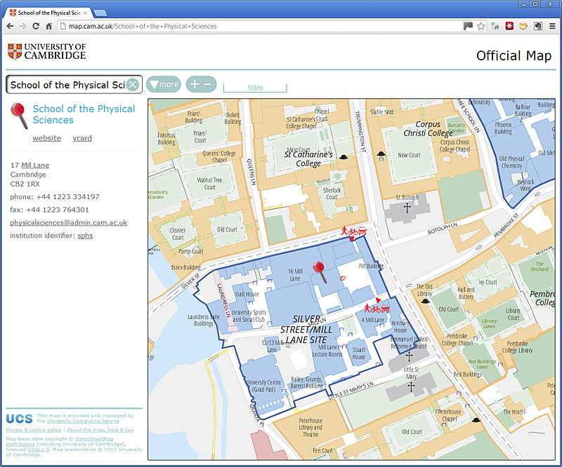
Project Drake to map the University of Cambridge (see http://www.openstreetmap.org/user/davidearl/diary/15398 ) involves micro-mapping University buildings. I'm aiming at typical GPS accuracies in doing this, but in areas where there is little or no GPS signal, so I have been measuring things on the ground with a laser measure. In principle this can give sub centimetre accuracies, but of course it is still subject to errors of various kinds (mostly human error or inaccessibility) which also accumulate. Nevertheless it is very accurate and in principle I ought to be able to get accuracies of a metre or so. And incidentally, it is gratifying to note that real distance measures in JOSM are extremely accurate: i.e. correspond very closely to accurate measurement on the ground.

But there are numerous sources of inaccuracy in the satellite pictures that I wasn't necessarily expecting, not having used them in areas of tall buildings before, which leads me to say that it is not wise to put too much faith in them, especially when you're down at metre level accuracies.

1. The obvious one. They are out of date. In Cambridge, sometimes very out of date. Not surprising that the University's Alison Richard building isn't there (opened last week), but the Gonville & Caius' Stephen Hawking building and vast swathes of Selwyn College are missing. More surprising, adjacent Bing tiles differ considerably in their vintage. To the extent that on one site I surveyed half a (not all that) new building appeared on one tile (completed, no sign of construction work) but the other half wasn't on its neighbour at all.

2. The biggie. Most of central Cambridge's Bing images are oblique views, some tiles more than others, and oblique from different angles in adjacent tiles. In other words you can see one or two sides of buildings. This means that for a 5 storey building, for example, there may be an offset of as much as 20m from the roof footprint to the ground footprint (and, of course, you can't see half the ground footprint anyway). It is so tempting to draw round the roof because that is usually lighter, clearer and you can see most of it. But the trouble is that buildings which vary in height (most of the University buildings!) have different offsets from the ground footprint, and unless you know what you are looking at, it is almost impossible to deduce levels from the air - or even necessarily that they are different levels. Of course, if we only want a rough outline, it is better than nothing, but it is not nearly good enough for this project.

Even worse, I have found many examples where buildings have been traced around the whole oblique outline, roof and sides combined. That makes the building footprint look vastly larger than it actually is.

Of course, if you know from a ground survey that there is nothing hidden on the "dark side", and that the roof level is constant or you have a good idea how it varies (e.g. where the bottom and top of a gable is) you can trace the roof and then shift to match the ground corner of the building - even at the expense of moving a road alongside the building which in fact is "under" the roof because of the oblique view.

3. Misleading detail. If you've not done a ground survey, and made detailed notes or photos, a satellite image can easily mislead into interpreting ground detail as roof or vice-versa. For example, Cambridge University Library had a big rectangular 'courtyard' out of its western wall. But this was actually an area of plant machinery on the roof (I think; the wall is continuous on the ground anyway)

4. Shadow detail. You simply can't see what's going on in areas of building shadow, and it is tempting to guess if you've not been there. Any you can't see colonnades, archways, or even a "street in the air" that is present ion one University site.

5. Rectification. Apart from the problem of deciding what actually is the correct positioning of the satellite tiles when they are oblique (it should be the ground positions, obviously), the accuracy with which the images have been rectified is an issue. It is clear from outlines offset by a few metres that the previously available Yahoo! images were rectified differently from Bing by 10 or 20 metres (I was always suspicious about Yahoo positioning given the volume of GPS co-ordinates I had that were consistently off). But even Bing rectifies differently across tile boundaries - buildings can shift 5 or 10 metres from one end to the other if they happen to straddle a tile boundary - or worse, disappear completely down the gap! It's not really their fault, it is a hard problem.

6. User error. The quality of outlines traced from satellites is often rather poor. I think this is largely because of limitations in how far you can zoom in in Potlatch, so what should be small rectangular steps in buildings don't turn out that way. You can be far more accurate in JOSM. But sometimes it is a case of mare haste less speed.

So my point is that I don't think you can treat satellite images as any more accurate or faithful in what they tell you than GPS co-ordinates, a ground survey or, yes, "millimetre accurate" laser measurement, but I think there is a strong temptation to do so which needs to be resisted. Perhaps this seems obvious, but there is plenty of evidence out there that says people are taking satellites pictures as gospel, sometimes shifting painstakingly made ground surveys to match the satellite prejudice.

That temptation is especially strong when you look at the satellite image and the building edge vectors and they don't seem to match up at all. In Cambridge University sites, this is often because the site has now been measured accurately from a reference point in an adjacent (or next-but-one) satellite tile and the rectification and obliqueness differences can be large across a 400m distance.

Or, of course, my measurements may sometimes be wrong!

Cambridge University comprises around 200 faculty, departmental and related institutions on 10 or so sites (several of which are rabbit warrens of building over centuries) and distributed in and around the whole city of Cambridge. It shares a biomedical campus with Addenbrooke's Hospital currently expanding by 50% and most years see several new buildings erected and departments move premises.

The University manages over 700 properties. It has 31 independent colleges each of which occupies sometimes two or three sites around the city and a few of which are as large as an entire campus University. It has over 17,000 students and over 9,000 staff (not counting those employed by colleges) and innumerable visitors.

They all need to find their way around.

So, since September, on behalf of the University's Computing Service, I have been cycling and walking around all the University and College properties, measuring and photographing, and entering the data into OpenStreetMap with a view to potentially replacing the University's existing online ( http://www.cam.ac.uk/map/ ) and paper maps. This is code-named 'project Drake' and continues until June 2012. It is a feasibility study, but the hope is that it will be proved sufficiently feasible that it can become a live system.

Of course, quite a lot of the University is already in OSM. Some colleges are already mapped down to individual trees; others are just an outline of the perimeter. Some University sites were missing altogether; others had been traced from satellite with no additional information and had errors that you might expect when viewing entirely vertically.

The University of Oxford already uses OpenStreetMap in its OxPoints project ( http://www.oucs.ox.ac.uk/oxpoints/ ). However, it is not at nearly the same level of detail - it merely uses OSM Mapnik tiles for presentation (I think). Drake will tightly integrate the geography in the OSM database with the institutional information from the University, and it will have its own rendering. There should also be an API - though perhaps not quite to the extent of OxPoints which offers 10 different formats.

What Project Drake is doing on OSM is
* adding all the necessary missing detail
* creating consistency across the whole University estate
* checking accuracy
* recording entrances to buildings and sites (none I have done so far
have had this level of detail)
* assigning identifiers ('ref=...' and 'operator=...') to sites, colleges, buildings and entrances (using existing University sources where appropriate) so we can link the non-geographical data in University databases to the geography in OSM, and to highlight the necessary features on the map and website. These IDs will also form the basis for a URL addressing scheme into the University's online maps.

And then there is a sizeable software component for creating the map tiles in the style to which they are accustomed, index, paper map and web site.

We're not attempting to map inside buildings (though there are interesting edge cases where long, wide, geographically significant gateways, and colonnades well within building footprints, have building entrances inside them, which we need to be able to locate). However, we are mapping buildings and their surroundings at a level of detail greater than any street/POI mapping I have done before.

I've published the tagging schema I'm working to, here: http://wiki.openstreetmap.org/wiki/Cambridge/University_of_Cambridge

A couple of notable things to draw from it are:
* the University and the Colleges are private property, even though many of them allow tourists to visit at certain times. The paths through them aren't 'permissive' as had been widely tagged previously ('permissive' paths have formal agreements to allow general passage while not becoming rights of way; that's not the same thing at all, and the institutions are understandably sensitive about this).
* I'm naming buildings by their name. May seem obvious, but it has been common for buildings to be marked according to their occupier. It is very tempting to say this is the "Department of Psychology" rather than the "Sir William Hardy Building", but the latter is the correct name. Of course, I am also recording the occupier as well, both in the index that will drive the University map and in an OSM tag, just not the name tag.

GPS is not a particularly helpful tool at this level. Many of the central sites receive no appreciable GPS signal at all, and even where the signal is strong it is not accurate enough. Bing satellite imagery is exceptionally helpful, but it is easy to fall into the trap of thinking because it is a picture it cannot lie (and I've found many instances where this has happened). I will write a separate diary entry about this shortly ( http://www.openstreetmap.org/user/davidearl/diary/15400 ). The University's own material is often helpful (with permission, of course, and where it is not contaminated with OS copyright).

My main mapping tool though has been a 50m laser measure. I have a trolley on wheels on which I have mounted a white target, so I can measure building dimensions up to convex corners. Where buildings are generally orthogonal and orthogonal to each other, this gives very good results. Old buildings often aren't straight or aligned with each other, but even where a building is too new to appear on satellite, it is usually possible to locate it with reference to one that is.

To date, all the enclosed University sites except for West Cambridge and Addenbrooke's have had the Drake treatment, and eight of the 31 colleges - Clare College, Downing, Gonville & Caius, Hughes Hall, Magdalene, Pembroke, Selwyn and Wolfson.

Watch this space for more on this exciting project as it progresses.

Location: Newnham, Cambridge, Cambridgeshire, Cambridgeshire and Peterborough, England, CB3 9LA, United Kingdom

@osmblogs

Posted by davidearl on 9 December 2010 in English.

I have created an automatic twitter feed from the RSS feed of the aggregated osm blogs, under the twitter name @osmblogs.

Of course you could follow it on twitter, but the main reason I did this is so that the combined blogs can be used as a source for flipboard on the iPad.

(if anyone did something similar already, sorry, I didn't know)

Whittlesey, Cambridgeshire

Posted by davidearl on 19 April 2010 in English.

(I haven't posted a diary entry for a while, but I have been busy over the winter as part of a hardy team of six that braved the ice and fen winds to map Wisbech and a large part of rural Fenland. I'll come back to that later as there's more to it than just the surveying).

However, moving on, Whittlesey (aka Whittlesea) is a small market town half an hour's bike ride SE of Peterborough. At 16,000 (2001 census) it is by far the largest settlement in Cambridgeshire not yet mapped and when complete will bring Cambridgeshire to around 97% complete (the next largest place is Ramsey, which another Cambridgeshire regular has done most of now too, and after that we're into villages with up to 2,000 people, mostly a few hundred, west of Peterborough).

So two of us headed to Whittlesey weekend before last and the data is going in now. It'll take another session to complete the town. Anyone who has gone by train between Peterborough and Ely will know Whittlesey from its brick works. The old chimneys are now complemented by an equal number of wind turbines. The town itself is nothing to write home about, though it has a pleasant market square in the middle. Like a lot of places, it's like an onion with layers of houses from recognizable periods. And to go with the onion, it is also home to a McCain foods factory, of Oven Chips fame.

NCN63 (which had already been added) passes through the town on its way from Peterborough to March.

Location: Whittlesey, Fenland District, Cambridgeshire, Cambridgeshire and Peterborough, England, United Kingdom

Had to go to the dentist today which took me to Great Shelford. Someone had noted a missing street on openstreetbugs so I went looking for it. Sure enough it was there, but no wonder I missed it - Glebe Lane it was and it looks just like a private driveway. I also found a small new development since my original survey and another, Abberley Wood (not Woods as the developer's sign says) that I knew about but had since opened up (still a bit more to do when they complete it).

Location: Great Shelford, South Cambridgeshire, Cambridgeshire, Cambridgeshire and Peterborough, England, United Kingdom

Fulbourn now completely house numbered. (Fulbourn village that is: there is a actually a section of Fulbourn parish that is actually connected to Cherry Hinton which I suppose I ought to do, but then it'll look odd that Cherry Hinton's not been done and then it would look odd that the rest of cambridge hasn't been done, ... - and there's places to map from nothing elsewhere in Cambridgeshire before that).

No great surprises this time, though a street name was missing. The construction site in the middle of Fulbourn is moving westwards - many of the old houses are now empty ready for demolition, and I didn't number those.

Location: Fulbourn, South Cambridgeshire, Cambridgeshire, Cambridgeshire and Peterborough, England, United Kingdom

85% of houses now numbered in Fulbourn, this time the eastern edge of the village, one more little local excursion should finish it. For my record, remaining bit is south: Cambridge Road, Shelford Road, Huntsmill; what streets are still left in the construction site off Cambridge Road; and School Lane, Ludlow Lane and also check corner of Home End/Ludlow Lane.

Fulbourn was one of the first places I surveyed, more than three years ago, and this re-survey reveals quite how much detail I didn't include when staring out that I would now collect. Also another two whole new streets gone up recently found and a cemetery discovered that I didn't know was there. The Fulbourn Centre (community centre) and recreation ground had virtually no detail before.

Also, someone doggedly shifted lots of streets in Fulbourn about six months ago to match the Yahoo images. This re-survey with a different GPS confirms the GPS was right (they match) and the shape of the streets had been altered incorrectly, so I was able to make some corrections there, St Vigors Road was especially bad. Also the satellite images are now rather out of date for the development that has happened recently.

Location: Fulbourn, South Cambridgeshire, Cambridgeshire, Cambridgeshire and Peterborough, England, United Kingdom

In Cambridgeshire terms, a bit like an uncharted backwater in the western spiral arm of the galaxy. Neverthless a little corner of the county bordering on Bedfordshire and Northamptonshire that was missing from the map.

It didn't used to be like that. Kimbolton used to be on the main A45 road from Ipswich to Birmingham via Cambridge and Northampton. The A14, a motorway in all but name a few miles to the north took all the heavy traffic away a few years ago, though the now B road along the Kym valley is still surprisingly busy. But the many-times-repaired wall on the extremely sharp and narrow corner of London Road shows the scars of quite how much of a bottle neck this must have been.

Kimbolton is pretty village, having more the feel of a small town really though the population can't be more than 2,000, dominated by Kimbolton School, an independent school based around a grand stately home with parts designed by Robert Adam. The High Street is especially grand, about 25m wide and almost a town square - leading up to the gates of the school - a bit like Marlborough in Wiltshire or Appleby in Cumberland. No less than two tea shops, excellent news for a thirsty mapper on a warm day, and a couple of up-market delicatessens, an old fashioned independent electricals store and an even older gents outfitters - it's a wonder they survive, though rich parents and students at the School no doubt bring a lot of money into the village.

On the way out from the bus at St Neots, paused to map Great Staughton, a dull little village. Kimbolton, being smaller than expected, left time also to map the next small village west, Tilbrook, and Kimbolton's immediate neighbour, Stonely. I also climbed a long hill out of the valley following Industrial Estate signs, only to find when I got home that someone had already mapped it, oops. Conversely I see I should have taken a small detour via a hamlet called Dillington on the way back for completeness.

Every time I go mapping west of the A1 I seem to get a puncture. This time was no exception. So a long day, and useful, but a lower mapping to wasted time ratio than I'd hoped: even having finished and had endless cups of tea, it was still one and a half hours to wait for the bus to St Neots, so biked it instead, only to have to wait an hour for the X5 to Cambridge which is supposed to be every half hour.

Location: Kimbolton, Huntingdonshire, Cambridgeshire, Cambridgeshire and Peterborough, England, United Kingdom

About 70% of Fulbourn now numbered. It's a slow, tedious business, house numbering, but it's handy for an hour or two on a Sunday afternoon, as it is on my doorstep and there's nowhere now nearby that is unmapped that is worth spending less than a whole day out mapping because of the travel time overhead.

I found another whole new street (The Swifts) has been built since originally mapped, and I discovered some more branches of one street (Cox's Drove) I'd missed previously because they just looked like driveways, but actually led to several groups of houses.

Location: Fulbourn, South Cambridgeshire, Cambridgeshire, Cambridgeshire and Peterborough, England, United Kingdom

Fulbourn, Cambridgeshire: house numbering

Posted by davidearl on 27 September 2009 in English.

I did some serious house numbering for the first time today, using the Karlsruhe Schema around my own home. I quickly realised it is a whole different way of mapping. If I'm going to do it on a bike, I need to find a way to attach a clipboard or something with easy access. I need to print out walking papers at a much higher zoom than I did as there's not enough room to write in the numbers at the scale I did it. And I need to collect tracks because hammer-head ends that I might not originally have marked become much more significant, and things change from the original survey and I need waypoints to mark changes in the numbering (e.g. a missing number) when there is no physical reference to pin it to on the existing map. It's sloooow work to get it right though. I'm sure I'll speed up, but I'm not going to try it everywhere, I'll just do it for my village for now.

And I did find changes: within 200m of my house, a new housing estate has been built. Now I knew that had happened, but what I didn't realise is that they had realigned the street pattern and changed street names when they demolished the old houses and built the new. Moral: always worth checking on the ground.

Location: Fulbourn, South Cambridgeshire, Cambridgeshire, Cambridgeshire and Peterborough, England, United Kingdom

Warning: this post contains tagging challenges!

Gorgeous day for a bike ride yesterday, so headed out to uncharted territory in the Fens. Little Downham is a village of about 3,000 people, 5km north west of Ely on one of the old 'fen isles', raised land which before the Fens were drained stood up from the marsh. They're having their carnival this weekend and for this they're having a scarecrow competition: so lots of the houses have scarecrows outside:

A couple of hours surveying saw Little Downham done, so on across the fens for the other missing link in these here parts, Mepal. The journey took in the already mapped (thank you, Donald!) settlements of Coveney and Wardy Hill. And some pumpkins. (You don't often see this strange sight in fields, though it is Halloween before long). This picture is from California. Yes, that's right: California, Cambridgeshire.

What wasn't already mapped (and still isn't in its entirety) is a network of by-ways surrounding and to the south of the village Wardy Hill. What makes these unsurfaced public tracks more than just more stuff to map is the tagging challenge they present. Suggestions welcome. Here's the sign:

So the sign excludes cars (and trucks), but there's then a timed exception for the whole summer but that itself has two exceptions, a negative one (even in summer cars can't use it if the gate is closed) and a positive one (in that you can get a permit). Bicycles, walkers, horses and motorbikes can use it at any time without hindrance - though if the gate is closed, it's not clear how you would get a motorbike through, and in some cases the "barrier" is a pair of bollards that you couldn't physically get a car through anyway. It's not obvious why anyone other than "slow modes" and local agricultural traffic would want to use these anyway as they don't offer any particular advantage or excitement, and they obviously aren't really wanted. Someone must have kicked up a fuss when they proposed closing them.

So finally, Mepal. It was smaller than I thought: it took less than an hour to survey so it can't be much more than 1,000 people, though it looks bigger. It's about 10km west of Ely and situated by the bridges that used to carry toll traffic across the Bedford Rivers between Ely and March. Now there's a bypass and the main road is carried across the channels on a long viaduct. The old road still winds through the village and the first bridge is still there, only really because it needs to serve a couple of houses built between the two big drains. The Three Pickerels pub by the bridge must have been not a little peeved when they suddenly found themselves at the end of a mile long no through road!

Whizzed back to Ely station with the wind at my back.

For anyone in this area in future, it would be very useful to see if West Fen Drove, a surfaced, though narrow road leading SW out of Downham links up with West Fen Road SE of Coveney. NPE kind of suggests it doesn't, but it seems like it should given the way it lines up, and it was a bit out of my way to find out. In fact the who network of droves and by-ways would be an interesting exercise - there's more out towards Littleport and Pymoor as well as the Wardy Hill ones.

Location: Dunkirk Farm, Downham, East Cambridgeshire, Cambridgeshire, Cambridgeshire and Peterborough, England, CB6 2TY, United Kingdom

Soham and Isleham, Cambridgeshire

Posted by davidearl on 25 August 2009 in English.

I thought it was just the southern end of Soham that was missing, but no it turned out that around half the town wasn't done, including a whopping area of new housing on the northern edge. So it took me rather longer than I expected to complete Soham. Nevertheless it is done now - thanks to Donald for the larger chunk that was already complete. There's an interesting area to the east of the town called Qua Fen Common (strange name) and the similar East Fen Common, which seems to be a large tract of genuinely common land. It's well used for grazing ponies.

Then over the fen to Isleham, a village of some 2,500 people 5km east of Soham and one of the the last outposts of Cambridgeshire in the east. Isleham is known for its old priory, but I also discovered the Isleham Lime Kilns, a 19th century industrial relic in the middle of a housing estate.

By the time I got back to the bus stop for home (the last three miles across the fens into a fierce southerly wind), I was ready to stop after seven hours continuously on the bike.

Location: Soham, East Cambridgeshire, Cambridgeshire, Cambridgeshire and Peterborough, England, United Kingdom

Fordham, Cambridgeshire

Posted by davidearl on 15 August 2009 in English.

The first time in ages I have mapped anywhere that has taken me less than an hour to reach by public transport. A fairly typical Cambridgeshire village, population just under 3,000, though it was apparent from the bus up from Newmarket that there was also a lot of industrial development south of the village, which I was able to complete as well. There was a skeleton of streets in place, but only about 20% completeness previously. Fordham has a rather magnificent water tower (http://www.geograph.org.uk/photo/252313).

There's a chunk of Soham on its southern edge which is not complete, (which almost merges into Fordham), so a good combination for another day would be that plus the village of Isleham, a couple of km further east.

However, I hadn't realised that when I was there, so instead headed south and filled in a small chunk of Newmarket (off George Lambton Avenue) where housing was under construction last time I was there. It's moved on quite a lot, but there's still construction going on. But three new streets have materialized.

Location: Fordham, East Cambridgeshire, Cambridgeshire, Cambridgeshire and Peterborough, England, United Kingdom

Completed the survey of Stansted Mountfitchet which I started a couple of weeks ago. SM is a community of around 6,000 (including Bentfield to the west of the old Cambridge Road, which I did previously).

I was then intending to follow NCN11 further south, but it appears that Stansted Mountfitchet station is as far as it goes at present (there's no signs other than back along the section I'd already done) - unless anyone knows different. I had expected it would head over to Bishops Stortford and then down the Lea somewhere, but if it does there seems to be a break in the route here.

So instead I headed up the road to Elsenham, the next small village north up the railway line towards home. It had had a bit of attention, but was by no means complete - and still isn't as my batteries ran out and my train was due. Another day. It won't take more than half an hour to do; it looks like Newport, the next station north, is well underway, so perhaps the neighbouring village of Henham would be a good target for a Sunday afternoon after Elsenham is done.

Location: Stansted Mountfitchet, Uttlesford, Essex, England, United Kingdom