
Drive-by surveying of road side fuel filling stations and use of satellite images for map update
Posted by arjunaraoc on 3 July 2023 in English. Last updated on 5 July 2023.I added 52 fuel filling stations which is 11.5% increase over earlier count of 451 across Andhra Pradesh. I spent about 10 hours logging the points of interest (POI) and another 10 hours updating them. Here is my backstory or how-to-do guide.
 I have been an OSM mapper from 2015, having learnt basics from PlaneMad and received mentoring from Heinz Vieth. I have been mapping occasionally about my neighborhood and places that I visit. I also installed Osmand on my smartphone and explored its navigation and trip and POI recording features. In my recent trip to my native state, I tried to record road side fuel filling stations as I drove on the roads as a passenger in car or bus. I used josm to update the OSM.
POI recording
 Setup Osmand and update maps to their latest versions. Install “Trip recording”, “Audio/video notes” and “OSM editing” plugins. Setup Trip recording profile to “Driving” or “Public transport” as the case may be. In the “OSM editing” plugin setting enable “Offline editing”. Setup OSMand to navigate to your destination. As you pass by a fuel filling station, record a POI by tapping with your finger, if the feature is not already visible on the map. Label it with a short label such as “petrol” or “hp petrol” (for filling station with brand Hindustan Petroleum for example). Continue this exercise for all points of interest. Even if you type the same name next time, the app will append the serial number to that name while saving it.
Create OSM file containing smaller set of POIs
Transfer the stored POIs from “My Places” menu of Osmand using the share button to your email account. Setup JOSM on your computer. Install “todo” plugin. Open the exported POIs file received via email (example: favourites.gpx). It will show two layers “favourites.gpx” and “Markers from favourites.gpx”. Select “Convert to data layer” option for the latter and you will end up with “Converted from: Markers from favourites.gpx” as your new layer, with the older “Markers from favourites.gpx” layer gone. Remove checkbox from “Discourage upload” corresponding to this layer. Save this layer as “favourites.osm” file. Depending on your trip, you may have lots of POIs to cleanup. I ended up with about 130 POIs for about 8 hours of my trip, which included other facilities as well. To make it easier to work and as “todo” plugin does not have the ability to save in progress status, create new files with each one containing approximately 10 POIs (by using copy from the original file and saving them in a new layer with “paste at source position”. After the new layer is saved, delete the POIs already copied and proceed to iterate for a new set of 10 POIs. You can name these files as ‘favourites part 1.osm”, “favourites part 2.osm” etc.
Cleanup with satellite imagery and upload
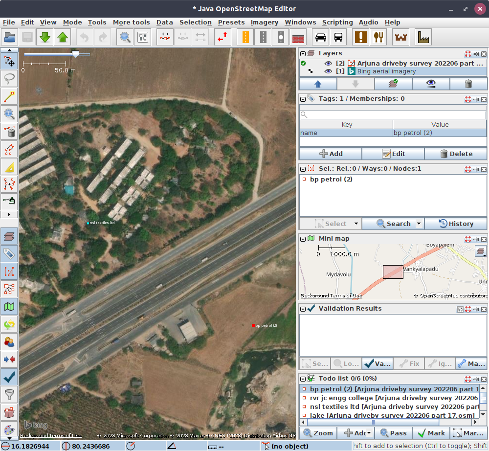 Start JOSM. Load the “.osm” file containing POIs to be cleaned. Select Edit -> search and enable “select all objects”. After all objects are selected, add them to “todo” plugin with “Clear and add” option under the Add menu button. Add Satellite imagery layer from one of the satellite image options like Bing.
Zoom to the first POI on your “todo” list. Adjust the zoom so that you can see the nearby highways on the satellite image. Select download in current view to see the already existing features of OSM. Locate the filling station from the satellite imagery, with its usually distinctive features of service roads from the highway and a rectangular reflective frame in the centre surrounded by building like features. If POI already exists, delete the recorded POI. If it is not present, move the recorded POI to the location of the filling station as per the satellite image. Apply preset of fuel from “Transport Group/Car” icon. Update the name as “Filling station” and update brand name if available from the label. Mark the item in the “todo” list. Your view will shift to the next item as the center. Repeat the steps.
If you do not find evidence of filling station from the satellite image, because the image is old and the construction is new, delete the POI from the layer, mark the POI and proceed to the remaining.
Once the cleanup is complete, upload your edits to OSM and use remarks such as “Update of facilities near highway” as “Description” or “brief comment” and specify the data source as “Drive-by survey during MMM YYYY and ‘Satellite name’ imagery”.
Repeat the above for all the “part” files and you are done. You have used your travel time productively and also contributed to a better OSM.
Discussion
Comment from fititnt on 6 July 2023 at 01:54
Great guide!
Comment from scai on 9 July 2023 at 13:05
Instead of creating POIs in OsmAnd you can also create GPX waypoints. Enable the trip recording plugin. Then simply tap on the map and choose Actions / Add track waypoint. You can add these waypoints to the currently recorded track or to any other track that is currently configured to be visible. Alternatively, create a quick action to create a track waypoint add your current position.
Comment from arjunaraoc on 10 July 2023 at 23:40
Thanks for your suggestions to speed up the drive-by survey. Usually I am interested in mapping several big road side features on both sides of roads and not just fuel filling stations. Sometimes, the road may be depicted as single way, though in reality it may be two ways one for each direction. Using way points in such a situation may lead to confusion. Anyway I will try them out.