
Highways & Byways: Roman & Drovers’ Roads in Ware, Hertfordshire
Posted by alexkemp on 7 February 2017 in English. Last updated on 8 July 2022.Most of the places that I’ve mapped across the last 10 months have been ~1930s with the occasional Victorian terraces (1880s). The topic today arose from looking at the deeds of a 1906 house but, as the first words of the first line below makes clear, has far more ancient origins:–
- In 13th Century England the following two, apparently contradictory, statements are both true:–
- Most people were born, lived & died within the same 5 mile (8km) radius.
- England was covered with a network of streets & roads each many hundreds of miles long; further, these streets & roads were continually thronged with people travelling long distances upon them.
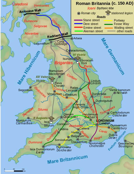
“Streets” here refers mostly to the well-known Roman Roads. During research for this Diary entry I was surprised to discover that Ware was positioned upon Ermine Street, a Roman Road that stretches from London to York & crosses the Humber close to my birth town of Hull. For reference, here is a map of Roman Roads:–
I’ve travelled Ermine Street a lot. My personal research suggests that, whilst the Roman Roads may have been occasionally used in Medieval times for long journeys, the local people had their own network of paths (nothing to do with the Romans) and which they preferred. So, the A15 runs north from Lincoln as straight as an arrow along Ermine Street, but it is perfectly clear that the locals preferred the B1398 which takes the same general direction but follows each field boundary & every circumlocution that it can find.
Well, that’s the Highways covered, but now the Byways.
“Roads” here refers to the less-well-known Drovers’ Roads. In order to spot one of these you will need to spot something like the following (hint: it is the words “Public Byway” that is the secret signal):–

When I were a lad the black ‘n’ white TV would often show black ‘n’ white cowboy movies. Frequently, these movies would involve a bunch of cowboys driving hundreds or thousands of cattle many hundreds of miles across the plains of America. Amazingly, exactly the same business happened in the UK, and across the same distances, and hundreds of years before the USA. Perhaps the main difference was that (at least in the movies) in the USA it was always cattle, but in the UK as well as oxen & cattle, there were also sheep, geese, turkey, pig, and horse drives.
The same routes were used every time & in places became worn down by the repetition (it is thought that some drove routes may have been used since prehistoric times). Many were much wider than other roads, at least 40 feet wide (12m) and up to 90 feet (27m) wide on occasion.
It seems that Ware had lots of Drovers’ Roads (look at ‘Musley Lane’) and, of course, pubs such as The Standard (now gone) to cater to the Drovers. However, as towns began to expand, the desire to allow a 12m road to remain diminished. In addition, such roads would have been anathema during the Enclosures of 1760 & later (aka legal theft). Nevertheless they do remain, much diminished in size and length, as Public Byways (and just to show how much of this info is new, notice that that wiki-link has zero mention of Drovers’ Roads).
So, how did I discover this?
One of the houses on Hampden Hill, Ware had a house-name & the lady of the house was available to give permission for me to photograph it. I asked if she knew the start_date which led to a short conversation, and she invited me in to look at the house deeds. These turned out to be a stack of vellum sheets (parchment — damn expensive stuff (20 sheets costs approx. £40,000 in modern value)) more than an inch (2.54cm) thick, each covered with beautiful Copperplate script (the lady’s Solicitor gave her these documents on completion of purchase; they used to be held by Land Registry but were all digitised some years ago & are now routinely returned to the house owner). A builder in 1904 bought Plot 27 (and also later Plot 28) for £30 GBP ($37 USD, €35 Euro) from The Commonwealth Estate (land formerly owned by Cambridge University). The builder was tied up with someone else, and it was all very complicated (I know already that most folks at the time rented — as a common example — on a 100 year lease rather than owned their house). It seems that the house was built on the two plots sometime after 1906.
The above was extremely interesting, but my attention was drawn by something at the extreme top-left of the site drawing (I wish now that I had photographed it): passing across the corner of the plot of what is now 17 Hampden Hill was a wide roadway (wrong number! - see below), and written on the drawing was “Old Drovers’ Road”. North of the plot for Hampden Hill is King George’s Field Recreation Ground; the Old Drovers’ Roadway came up from the left of all the plots for Hampden Hill, passed across the top-left of that plot, and continued across the southern-base of King George’s Field to the right. I was intrigued; what on earth was a Drovers’ Road?
Later in my mapping I had a chat with the son of the owner for the house on the corner of Hampden Hill and Hampden Hill Close (he came up to me with one of those “what on earth do you think you are doing?” questions whilst I was photographing the street-sign). The house turns out to have a Medieval hedge that runs along Hampden Hill Close.
So, that old drover’s road starts in modern times as a Public Byway sign (9 miles) (14km) on Musley Lane and travels along a footpath which terminates at the end of Hampden Hill Close. The Byway signs finish at this point, but it definitely continues along Hampden Hill Close (it’s a cul-de-sac), then Hampden Hill to the top-centre & the opening into King George’s Field. It then travels behind the Jolly Bargeman & will still have another 8 miles to go!
Coda 1: This Drovers Road on OS 1.25k Historic (OSM-Limited)
(below is a single are tiles obtained via JOSM; these tiles seem not to want to sit together on the same line; I tried using HTML <table> tags to stitch some tiles together to show a better view, but this OSM *Markdown* did not want to know then — July 2022 update — tried with current kramdown and got a positive response, although I do not seem able to persuade them to sit close together).
 |
 |
 |
 |
 |
 |
The vertical road above (bottom centre) is Hampden Hill up to the 1906 house; the modern road continues up and turns a right-angle to the right. The grey road that crosses Hampden Hill above it marked (top right) as ‘FP’, although other footpaths are shown as dotted black lines) is the Old Drovers’ Road. It begins on Musley Lane exactly where the modern signpost is (bottom left) and follows the modern Public Byway very closely indeed. Hampden Hill Close is exactly on it’s southern border almost all the way to Hampden Hill and it actually passes through numbers 11 & 9 Hampden Hill rather than 17 as I said before. It also leaves the modern Hampden Hill exactly at the point where the modern King George’s Field footpath begins & even follows the north-east footpath through the recreation ground. It’s quite uncanny. That modern footpath turns sharply to the right & emerges on Cromwell Road, whereas the Old Drovers’ Road continues straight ahead & behind the pub, running parallel, but 100 yards or so to the west, of Cromwell Road.
This ancient road then gets lost on the modern map, although small traces are left behind. Tracing it to the north we see that Dark Lane (a bridle path) lies on the route, as does an un-named bridle route trace part of a spur that goes east via close to the join of the modern Woodley Road with Cromwell Road.
It is the fact that ancient ways continue to influence folks today that causes me to be fascinated by this stuff. One little connected story to finish:–
I was visiting my grand-kids in Ware last year when they said that they were going to give Buddy (their yappy little dog) a walk, and would I like to come? We ended up in the King George’s Field park, then into Hampden Hill and, sure ’nuff, down the Public Byway on to Musley Lane, then home. All these centuries later, folks are still walking those tracks.
Coda 2: Yet More Intelligence
In 1904 the Drovers’ Road was the only road that existed to the East of Ware (in JOSM, use the NLS Bartholomew 1897-1907 Imagery). It travelled from Fanhams Hall Road in the north to Musley Lane in the south. By the 1930s a number of things had happened (the NLS OS 1.25k 1st Series 1937-1961 imagery is useful here):–
- The 1920s & 1930s building spurt that followed WW1 had begun to extend from Victorian New Road/Musley Hill eastwards into the Commonwealth Estate.
- Such building stopped at the Drovers’ Road, in the same way as the earlier Hampden Hill had stopped at that road.
- The Drovers’ Road fell into disuse. The far-northern end was retained as was the far-southern end, but the middle section stopped being a ‘road’ & became a ‘footpath’. As development continued & memories faded or died, even the footpath became a distant story buried within house back-gardens or behind the pub or upon a piece of parchment.
Via an East Herts Council map (up-to-date map supplied by the OS; have patience, it is dog slow) I found that the southern footpath is also called “Dark Lane”, which suggests that the entire section of road may have been called that. I’ve not spotted any signposts with that name on the path, but will ask around at my next visit. If anyone says yes I will name it!
Extra
The word “Driver” is directly derived from the word “Drover”. It is for this reason that some folks insist that legally a Driver’s License can only apply to Commercial drivers & not to those driving for leisure (non-commercial purposes).
PS
Experimenting with Dingus I was able to build a Markdown <table> that made a decent fist of stitching OS 1.25k Historic tiles together to show the route of that Old Drovers’ Road. However, then found that this Diary’s version of Markdown did not support it. Bugger.
7 July 2022: kramdown has replaced Markdown within these diaries, and that supports <table> (which is good) both as html & as kramdown-markup. However, osm uses a CSS which super-imposes a 20px padding inside each cell of the table. Inline style within a <table> or an <img> element will NOT overide that external stylesheet. Unfortunately that means that the map-tiles will not stitch together seamlessly.
Update 7 July 2022
Mapillary has changed it’s download URLs & therefore all links within my diaries that used a Mapillary download URL in the old format are broken (the Mapilliary map URLs, which show a photo within the context of an OSM map, have also changed and are redirected via a HTTP/1.1 302 Found, but the download URL hostname no longer exists and gives a “No address associated with hostname” DNS error). I’m slowly going through to update them. The new URLs are terrifyingly long, but show OK on my screen (and I hope also on yours).
Discussion
Comment from andy mackey on 10 February 2017 at 00:02
I look forward to reading your experiences Alex. I lived in Durvigutum ( Godmanchester ) for most for my first thirty years, Godmanchester was a junction of quite a few roman routes one that goes south to Sandy isn’t even a footpath for much of it’s route now, Ermine street as also been obliterated for a spell in the Stamford area, I guess the land owners didn’t want visitors. There’s a Bullock road which runs parallel to the A1 near Sawtry that was used by drovers, to avoid the toll, I was told. Some livestock needed “boots” as their feet weren’t up to long walks. see link. Thanks for your interesting entries. https://hoofcare.blogspot.co.uk/2011/11/thanksgiving-shoes-for-turkeys-trot-to.html
Comment from alexkemp on 10 February 2017 at 15:46
@andy mackey: loved that link. I suspected that the USA would drive far more than just cattle. However, I also suspect that the cobblers used something other than nails for geese & turkey boots (not a job I’d like). And what a job driving geese must have been! Next to a cat herder one of the most difficult jobs in the world, I would have thought, and especially during the migration season.
Comment from Stereo on 11 February 2017 at 11:39
Thank you once again for your interesting diaries. It seems that in every city built along an old road, you can still recognise the orientation of the long gone road in the city’s grid.
Have you looked at Leaflet instead of <table> to create simple web maps?
Comment from alexkemp on 11 February 2017 at 11:41
@Stereo: Can Leaflet be used within these Diaries? Because that’s what I was talking about.
Comment from Stereo on 11 February 2017 at 11:42
Ahh, no they can’t, you’re right.
Comment from amapanda ᚛ᚐᚋᚐᚅᚇᚐ᚜ 🏳️🌈 on 18 April 2017 at 12:44
So those aren’t necessarily contradictory. One simple solution: 90% of the population was born/lived/died in their home village, and 10% of the population went all over the country.