OpenStreetMap

Stalfur's Diary

Recent diary entries

I’ve now made two maps for Mapping Botswana to show people that even if a map looks inert when you look at it, behind the scenes a lot is happening, just not maybe in the area you are looking at now.

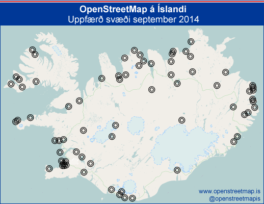
So I’ve created one for Iceland as well.

Changes in Iceland in September 2014

This is not an exhaustive list but shows the major names that got updated:

  • Akranes
  • Álfaborg
  • Ásbyrgi
  • Bakki
  • Blönduós
  • Bolungarvík
  • Borg í Grímsnesi
  • Borgarfjörður eystri
  • Borgarnes
  • Brynjudalur
  • Brúnavík
  • Dalabyggð
  • Dalvík
  • Djúpivogur
  • Dyrhólafjara
  • Eskifjörður
  • Eyjafjarðarsveit
  • Eyrarhús
  • Fimmvörðuháls
  • Fjarðabyggð
  • Fálki
  • Garðabær
  • Gufuskálar
  • Gæsavötn
  • Hafnarfjörður
  • Hafragil
  • Hnjótur
  • Holuhraun
  • Hvalvík
  • Hvítárvatn
  • Hólar
  • Höfði
  • Húsafell
  • Húsavík
  • Ísafjörður
  • Knarrarnes
  • Kópasker
  • Kópavogur
  • Langholt
  • Laugar
  • Laxamýri
  • Lárós
  • Mosfellsbær
  • Neskaupstaður
  • Norðausturvegur
  • Núpur
  • Ólafsfjörður
  • Reykjanesbær
  • Reykjavík
  • Sauðárkrókur
  • Selfoss
  • Siglufjörður
  • Skaftafell
  • Skagafjörður
  • Skógaeyrar
  • Skógar
  • Skútustaðir
  • Svarfaðardalur
  • Tjörnes
  • Upphérað
  • Valdasteinastaðir
  • Vatnsdalsvatn
  • Vesturbyggð
  • Vopnafjörður
  • Vík
  • Þingvellir
  • Þjófadalur

Mapping Botswana via Facebook

Posted by Stalfur on 13 March 2014 in English.

For the past 6 months or so I’ve been doing groundwork to get Botswana up to speed on OpenStreetMap, this includes obtaining information from the Census 2011 to find all villages and using Wikipedia and other sources to find the GPS co-ordinates.

The next step was to expand the WikiProject Botswana page and then to create Trello-taskboards to have an overview of the status of each of these villages and towns and hamlets.

A Twitter-account @mappingbotswana posts updates to the mapping process and finally a Facebook-page was set up to introduce the project to the Matswana (residents of Botswana).

From Facebook a request arrived about Khawa/Khwawa, a small village in the Kgalagadi region. I mapped it quickly using the Bing images and then on Facebook engaged with Tshegofatso Dipatane who provided more detail based on these screenshots I showed her with a grid added to them.

Khawa aerial #1 Khawa aerial #2 Khawa aerial #3 Khawa aerial #4

Getting the local people to use iD would of course be optimal but by showing this interaction we can hopefully draw more people into contributing by showing them how easy it can be.

Location: Khawa, Kgalagadi District, Botswana

Happy 9th birthday OpenStreetMap!

I came late on board, in 2009 I made my first changes as I fixed the area closest to me that was missing some streets.

It wasn’t however until April 2013 that I started to seriously contribute. Looking at the metropolitan area in Iceland I noticed that all the neighbouring towns had plenty of buildings while for my hometown, Kópavogur, only the Vesturbær (Westside) had any buildings in it. This rankled me and I decided there and then to improve matters, it was unthinkable that the most populous town in Iceland was so lacking in data (Reykjavík is more populous but is also not a town but a city), a mere skeleton surrounded by better looking neighbours.

I started to improve my current neighbourhood, Smárar (Clovers) and that took a good while as I got to know what each feature should represent. Potlatch2 is a fine editor but fairly advanced and getting to know where things were hidden in it took a bit of time and I read the wiki extensively.

I decided to stay afloat in this task, to populate buildings, streets and pedestrian routes (including sidewalks) for a town of 35 thousand people, by dividing it into 20 smaller tasks on Trello (online task management board, free to use).

I got curious to see what other towns in Iceland were in a similar state to Kópavogur and so took a round-trip around Iceland in OSM and set up a task-board for it on Trello, marking which towns and villages lacked imagery (Vantar loftmyndir) or lacked buildings (Vantar loftmyndir). It serves as a rough to-do list for Iceland and allows us to monitor, when new imagery is added, if places have suddenly obtained imagery and can be moved to the next category.

It has taken me from April 15th 2013 until August 8th 2013 to populate my town with buildings (including house numbers) and pedestrian routes, plus adding and fixing streets. During that time I’ve used my GPS-device and bike to do detailed tracking of places where imagery was mangled, for example in Hvörf and updating Vesturbær. It is finally done, new buildings are being built and some sidewalks are missing but overall the health of the map is now more than adequate for use. It is of course a never-ending task to keep up to date but getting to a stage of this completeness greatly helps out for future tasks. The introduction of iD during this time made my task easier, for drawing up buildings and other areas it is much more user-friendly and I’ve been translating it to native.

I’ve tested the map by using the Garmin map of Iceland on devices lent to me by friends, Garmin 62 worked perfectly while Garmin Nuvi had some problems with addresses.

OpenStreetMap in Iceland started on June 15th 2007 when a team of people went on their bikes and started recording their tracks, they made a very nice video of how they began mapping the metropolitan area with Reykjavík quickly becoming very detailed street-wise. As I said when I began my work it was because of the work of those that had already mapped out Reykjavík, Hafnarfjörður and Garðabær and surrounding area with buildings. If everyone of these had been as empty as Kópavogur was I probably would not have set myself this task and it would still just be a skeleton of streets. So a big thank you to all of my fellow mappers, both in Iceland and abroad, and those that create the fine editors Potlatch, JOSM and iD.

Happy birthday to all of us!

Location: Tungur, Digranes, Kópavogur, Kopavogur, Capital Region, 200, Iceland