More hiking routes between Wlen and Lwowek Slaski
Posted by Recursive Loop on 6 January 2013 in English.Witam!
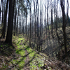
Added some more hiking routes between and around Lwowek Slaski, Mojesz, Plawna, Denbowy Gaj, Sobota, Marczow, Wlen and Lupki! What a great area to hike around, beautiful!
All track were collected using GPS (instead of copying Bing), so they should be walkable.
Unfortunately, more and more parts of the tracks are being plowed over and access roads are being claimed as part of private property. As a result, some of the original long distance tracks between villages are starting to deteriorate. It would be a real shame if they disappeared, maybe it’s time for an official ‘deteriorated footpath’ designation in OSM.
Best regards, RecursiveLoop
Discussion