OpenStreetMap logo OpenStreetMap

OpenBrian's Diary

Recent diary entries

After years of development, I am excited to introduce a proposed feature for OpenStreetMap called Communities. Formerly called Microcosms, this feature is designed to bring mappers together and facilitate collaboration. On the main OSM website, it will be located on the Communities page.

What is Communities?

Communities are groups of mappers who share a common goal or interest. They can be formed around a specific geographic region, such as a city or neighborhood, or centered on a particular theme, like humanitarian mapping. The purpose of Communities is to provide a platform for mapping teams to connect with one another, work together as a team, and organize events.

Community Mapping Event

Key Features

  • Create communities of mappers based on geography or shared interests
  • Assist local mappers by reviewing local changesets
  • Organize events, such as “mappy hours”, learn-to-map sessions, armchair mapping meetups, HOT mapping initiatives, and on-the-street mapping
  • RSVP to events and connect with other attendees
  • Focus on diary entries in your geographic area

Try it out!

You can test the Communities feature at our demo site: https://microcosms.apis.dev.openstreetmap.org/. Register an account to start exploring. If you just want to watch a video, see my talks from old State of the Map US conferences

Development and Feedback

The Communities feature was developed on GitHub: https://github.com/openbrian/osm-microcosms. If you have any comments, suggestions, or requests for features, please leave them there as issues.

This may be merged soon, but I want to make sure Communities works for organizers and members. Going forward, there are numerous ideas to explore such as integrations with completeness tools, delegating changeset review by vicinity, filtering on relevant historical changes, comments/discussion on events, and export and event feed to calendars.

Thanks to Clifford Snow, Adam Hoyle, and the OSM Local Chapters and Communities Working Group.

Let’s bring Communities to OSM!

If you think this feature would be a valuable addition to OpenStreetMap, please let me know. Your support will help bring Communities to the wider OSM community.

Note: This is not to be confused with the OpenStreetMap Forum. The Communities feature is more closely related to the Community Index and aims to provide a platform directly on the OpenStreetMap site.

Microcosms Ready for Feedback

Posted by OpenBrian on 7 June 2020 in English.

What’s Microcosms

Microcosms is a upcoming feature in the OpenStreetMap website to support local communities of mappers. Each microcosm is focused on a city and has a team of mappers working on improving OpenStreetMap in that city. The microcosm can organize their upcoming events and track RSVPs.

microcosm
noun
mi·cro·cosm | \ ˈmī-krə-ˌkä-zəm \
Definition
1. : a little world
2. : a community or other unity that is an epitome of a larger unity
source: Merriam-Webster

Development

Work started last year and is picking up lately. During development, microcosms is a fork of OSM called osm-microcosms. There’s a PR for early feedback from the website team.

The website team has a high standard for quality and I appreciate that. I continue to write automated tests for all the new code I create.

A design document is available to get an idea of what’s done and what’s to come.

Community

The Local Chapters and Communities Working Group has taken an interest in Microcosms and I’m glad to provide something to support them. Check them out on Matrix.

I’ll be giving a talk in the OSM US series of Mappy Hours. I’m scheduled for June 9th. And I’m talking to Austin about being on his podcast Nodes and Ways.

User Feedback

Thanks to Tom on the OSMF Operations Working Group we have a beta website for user feedback.

I’d love to hear what you want in Microcosms. What’s working well? What’s working poorly? What features are missing? Please file your issues and I’ll work on them.

OSM Testing Site: Microcosms


Brian DeRocher is the organizer of MappingDC.

Routing with OSRM

Posted by OpenBrian on 19 May 2017 in English.

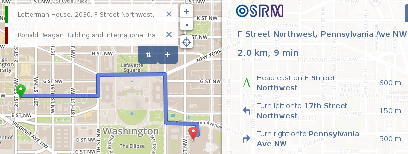
Setting up OSRM is very easy because it’s using Docker. Here are the steps to take to set up your own router. You can run this locally or on a server. To see this in action check out https://mappingdc.org/bike-router/.

OSRM on MappingDC

  1. Install Docker on your machine according to instructions for your operating system. https://docs.docker.com/engine/installation/
  2. Download a PBF file for your city from the Mapzen Metro Extracts (https://mapzen.com/data/metro-extracts/). If there is none, sign up and request a new one be built.
  3. Run the backend docker commands from here https://github.com/Project-OSRM/osrm-backend#using-docker This takes about 30 minutes as it precomputes some data.
  4. Run the frontend docker commands from here https://github.com/Project-OSRM/osrm-frontend#using-docker Start the front end with the -e option that specifies the URL to your backend, e.g. http://myhost/osrm-router/
  5. Open ports on your firewall, or set up a proxy in Apache like this:

     # Frontend
     ProxyPass /osrm http://127.0.0.1:9966/
     ProxyPassReverse /osrm http://127.0.0.1:9966/
    
     # Backend
     ProxyPass /osrm-router/ http://127.0.0.1:5000/
     ProxyPassReverse /osrm-router/ http://127.0.0.1:5000/
    
  6. Visit http://myhost/osrm-router/
Location: Mount Vernon, Alexandria, Virginia, United States

JOSM tip for squaring buildings

Posted by OpenBrian on 16 May 2014 in English.

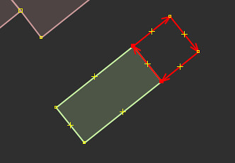
We all know about Q in JOSM, which will make the angles in a building 90°. But isn’t it annoying when you have one building, you are adding an adjacent building, and when you square the corners it affects the first building? Here’s a pro-tip. When squaring the second building, select it, then add 2 nodes from the first building into your selection. Then hit Q. It will use the first building as a baseline for the second. Notice 2 nodes are highlighted red.

square building