NKA's Comments
| Changeset | When | Comment |
|---|---|---|
| 123260193 | over 3 years ago | Fint om du kan unngå å legge inn objekter som ikke eksisterer, dvs ikke legge inn tags med verdien «no» eller «none». |
| 123092101 | over 3 years ago | We are trying to avoid adding bus routes in Norway. The creators seldom bother to maintain them in the years ahead, and they make highway maintenance a lot more difficult. |
| 110879211 | over 3 years ago | Pls. ikke lanes=* uten at det er merket opp kjørefelt. Og ikke sidewalk=none/no osv. |
| 122910564 | over 3 years ago | Please revert this and similar Tomtom changesets. There should be one amenity=school, not three. Why are you doing such modifications? |
| 122886764 | over 3 years ago | This is a track, not a path. Please do not change from higwhay=track to highway=path in your changesets in Norway. |
| 122887413 | over 3 years ago | This is a service way, not a cycleway. Please use Norway Orthophoto background imagery when editing in Norway. |
| 122888349 | over 3 years ago | Please do not change from higwhay=track to highway=path in your changesets in Norway. And please use the "Norway Orthophoto" background imagery in Norway, not Maxar, Bing etc which has considerable offset. |
| 122888545 | over 3 years ago | Why did you change from highway=track to highway=path. Track is clearly correct. And please use the "Norway Orthophoto" background imagery in Norway, not Maxar which has considerable offset. |
| 122777472 | over 3 years ago | Noen innspill til taggingen her: * cycleway:... = exclusive brukes ikke i Norge * Man bør ikke bruke -1 sammen med oneway. Bruk i stedet cyclway:left=lane * Vi bør ikke ha egen tagging for sykkelveier i Oslo, så oslo_standard:cyclway må fjernes. Om dere har spesielle behov må tagging av slikt diskuteres på forumet. Kom gjerne innom IRC så får du hjelp. Ellers: Ikke bruke Bing i Norge, den har betydelig offset. |
| 122630322 | over 3 years ago | Please use Norway Orthophotos as bacground imagery. All other sat images have large offsets. |
| 122122892 | over 3 years ago | «Disabled» is listed in the «Transport mode restrictions» of access=* |
| 122122892 | over 3 years ago | I think toll:disabled=* fits well with the instructions given by the wiki for barrier=toll_booth (barrier=toll_booth): "If the toll applies only to particular type of traffic, e.g. only HGVs, add the appropriate sub-tag of toll=*, such as toll:hgv=yes in the example." |
| 121996099 | over 3 years ago | Bare et tips: Det er ikke nødvendigl å tagge lanes=* for standardverdiene (som er lanes=1 for enveiskjørte gater og lanes=2 for vanlige gater). Selv synes jeg det er en fordel å ikke tagge dem da - taggingen blir mer oversiktlig. Og kun ha lanes=* der hver enkelt kjørebane faktisk er merket/malt. |
| 119224206 | over 3 years ago | It is here: osm.wiki/Import/Catalogue/Central_place_name_register_import_(Norway) |
| 119344157 | over 3 years ago | There are several problems with this changeset: 1) The first new highway is overlapping with the second new highway. 2) The second new highway is overlapping with the existing Hönsa-Mossebo highway. I am assuming that these new highways have been extracted from an import source (LM?) and that there is a script which tries to merge them with existing highways. However this method needs to be refined before it continues. Why have you created several new user accounts to do the import? Adding new highways is an ok activity but it is better to do it in a transparent way. This import is very visible anyway. Import from NVDB is already approved, so no need to create a new import plan. |
| 111319609 | over 3 years ago | Du har importert 20 stedsnavn til Nord-Aurdal kommune i dette endringssettet. De må ha blitt flyttet flere kilometer fra en helt annen kommune før de ble lastet opp. Eksempel: node/9099808586/history Det er også en del place=isolated_dwelling i Etnedal kommune som ligger helt feil. De har nok også blitt flyttet. Eksempel: node/9099886465/history Fint om du kan rydde opp i dem - bare å søke opp "ref:hovedgruppe" (forøvrig en tag som ikke skal lastes opp til OSM). Jeg har fjernet tilsvarende stedsnavn som hadde havnet i Øystre Slidre. |
| 117461674 | almost 4 years ago | @archie: I ser nå at du kan ha misforstått "on the ground" regelen. Det er intet krav i OSM om at navnet må stå på et skilt på bakken for å komme med i name=*. Om det hadde vært regelen så kunne vi ikke tagget name=* for en fjelltopp eller en innsjø uten at det står et skilt der. Navn fra åpne og allmenne kilder (i dette tilfellet eieren Tesla) er akseptert og lar seg verifisere. Derimot nevnes det ofte som eksempel at dersom et gatenavn er stavet på én måte i et offentlig kart og på en annen måte på det fysiske skiltet i gaten, så er det skiltet på bakken som gjelder (men et slikt tilfelle har vi ikke her). |
| 117447419 | almost 4 years ago | |
| 117461674 | almost 4 years ago | Please let us have the discussion in the other changeset. Furthermore, it is bad practice to revert in the middle of a discussion. Here is what you call "a couple of electrical outputs": https://www.youtube.com/watch?v=y_aTV3E9d54 I did not introduce the name. That was done in earlier changesets by other users. And there are many Tesla signs at the location. The name is not invented - it is the official Tesla station name. I do not care about the address tags. I reintroduced them from an earlier version because another user asked for them. I will not reply further here, but in the other changeset. |
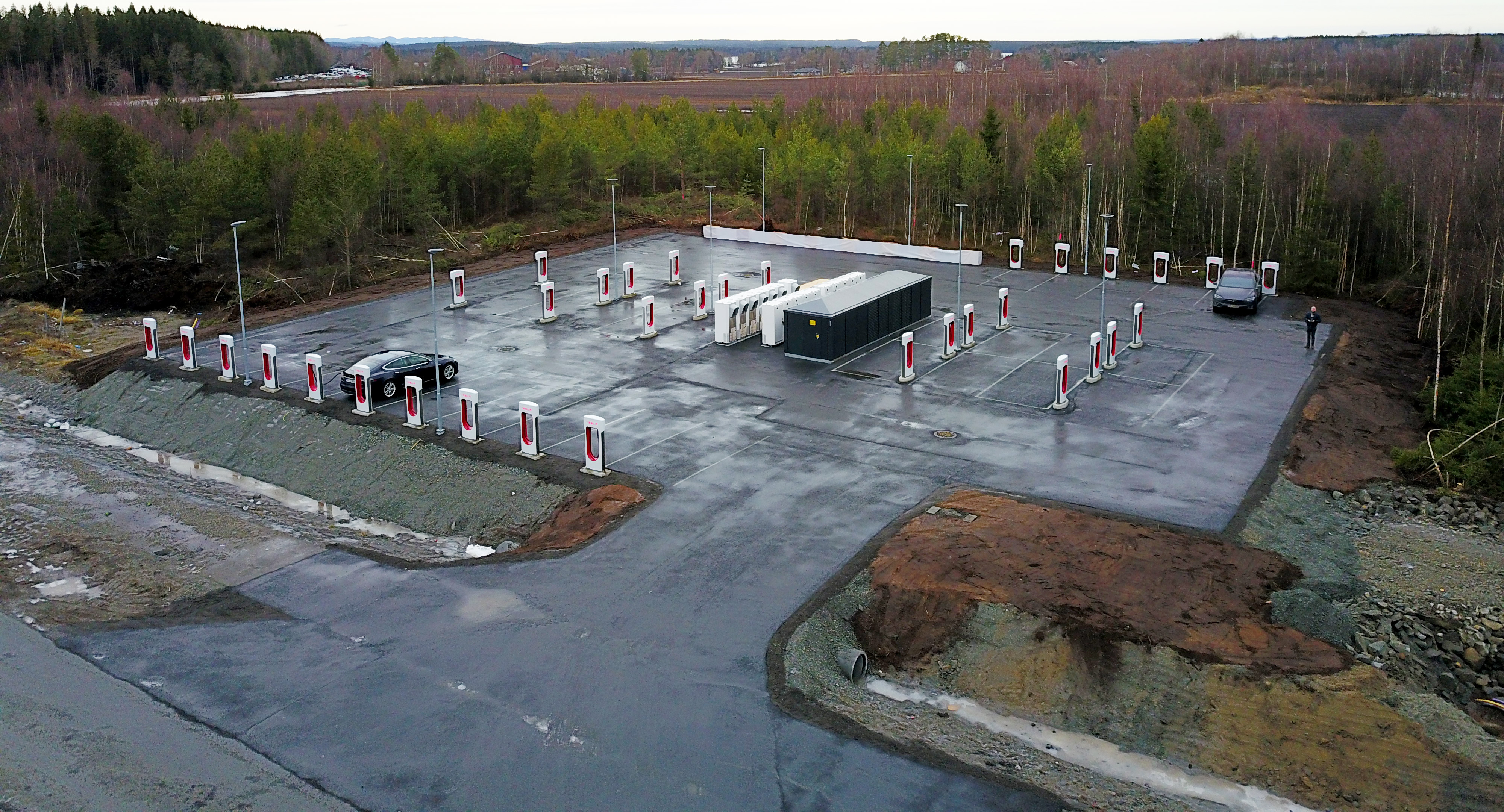
| 117361552 | almost 4 years ago | We are not discussing individual chargers/sockets here, similar in size to an ATM, but larger high capacity stations/sites, similar to a fuel station. Some of them have dozens of chargers.
The Tesla Supercharger stations have all been given names by Tesla, which we refer to when we carefully plan our trip to avoid a flat battery. The names are shown on the Tesla webpages, in the charging app, and in the Tesla cars. All the other general charging apps also use these names. The stations and their facilities are being discussed by name, by the Tesla users and others. The stations names are also referred to in media when they cover the latest expansions.
774 of the 844 supercharger stations in OSM have name=*, of which 164 have only "Tesla Supercharger" and the other 600+ stations have the longer station name given by Tesla. The other large charging station brands in Scandinavia also have station names and refer to them extensively for their several hundred charging stations. They are well branded, well beyond a "street lamp", and the brand is important to us due to subscriptions and pricing.
Electric cars have taken a huge share of the market in Scandinavia, with for example only 8% of cars sold in Norway 2021 being fossile only. As this trend continues, the charging stations and the competing brands are quickly developing into destinations which are equally important to fuel stations and supermarkets. Of course these stations are worthy of a name=* so that they can be identified on the map and in apps/other consumers, otherwise OSM would be at a disadvantage. And it would be good if the local community could have the permission to discuss the matter (however I think a forum thread would attract more community interest than these random changeset comments). |