
Pakistan Remote mapping Workshop
Posted by Harry Wood on 28 October 2010 in English. Last updated on 29 March 2011.We had a Pakistan Remote mapping Workshop last Thursday. For quite a while now I've pondered variations on the format of a normal mapping evening/pub meet-ups, and I was thinking about this event in those terms, but this was no minor variation. It turned into something totally different. All the usual group of people didn't sign up. I assume this was partly because they're not that excited by the idea of remote mapping, partly because they're not that excited about journeying to that rather awkward corner of North East London, but mainly because they failed to sign up in time. The event was quite suddenly over-subscribed with all 18 places (the capacity of the venue) taken by people keen to learn about how to help map Pakistan as part of humanitarian OpenStreetMap work. All of them were new to OpenStreetMap.
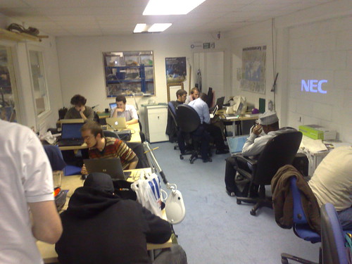
The popularity of the event was thanks to Spike, who was the chief organiser. He arranged the London Hackspace venue, and got lots of interest via Crisis Camp channels.
Showing the ropes to OpenStreetMap beginners is always a task I enjoy. A room full of 18 of them was a lot of fun, but quite a big challenge. I had hoped to have some assistance from one or two other OSMers, making it more like the second day of the UCL student mapping party ...but no. Just me. To set myself even more of a challenge, I was teaching them JOSM. This was something I had decided in advance because the specific task I wanted to get people doing, was tracing Pakistan SPOT imagery, which is not available in Potlatch... and besides I heard they were going to ban potlatch :-) So my plan was to show them not only how to map in JOSM, but also start with installing the WMSPlugin, configuring the SPOT WMS URL, and setting the required projection. I think everyone did this in the end, but I made a mistake in allowing them all to go at it at their own pace. I should have just demo'ed the whole process on the projector. With only me to help, running between people showing them through the various stages was a bit too hectic, and from their point of view I'm sure it made the whole thing seem more difficult than it actually is. The process, by the way, is spelled out more clearly in my tutorial video. The group seemed to have mixed technical abilities, but it took at least an hour to get everyone to the stage of seeing the imagery.
After that I'm more in my comfort zone, explaining how to edit in JOSM, starting with the three main modes with keyboard shortcuts 'S', 'A', 'D'. Then come the awkward generic mapping questions. Should it be highway=road/residential/unclassified? Just how accurate do we need to be? Should we move this data that appears to be in the wrong place? etc. All good fun. I think most people even got to the stage of writing a comment and uploading!
More photos from Spike on flickr
Big thanks to Spike for organising and to the London Hackspace for providing their wonderfully hacktastic venue. I also left them with an bestofosm.org poster as a thankyou pressie.
If you're interested in attending a similar event, we're hoping to do a remote mapping party again some time. If you're interested in attending a normal mapping party, well we're mapping Covent Garden TONIGHT! details here, and they'll be other London events over the winter.
Lessons learned
As mentioned, I should've done things on the projector beforehand, and/or had more OSMers helping, but besides that there's a few usability things I could list out, along the same lines as Andy's usability notes after the UCL event. Here I'm mostly noting things related to the getting set up with imagery.
- Installing plugins: The preferences screen has large icons down the left. Users have to find a picture of a plug socket. Although pretty, I think smaller icons with text alongside would make things easier. Other apps often seem to go for a list or a tree on the left. That might remove the need for multiple tabs on the 'Display settings' too.
- Why do you have to click 'download list' to get a list of plugins? Surely it could just (try to) download the list automatically to first time you see it. One less step for beginners to have to figure out.
- The wiki pages should perhaps be re-organised to give easier access to the SPOT WMS URL. Current way to find it: Find the 'Pakistan' page > '2010 07 Pakistan Floods' > 'Imagery & sources' ...scroll down
- Really the WMS plugin should somehow know the WMS URL. Ultimate would be if it knows available imagery dependant on the area you're looking at, but at least SPOT should be available to pick from somewhere (where are those 'defaults' coming from?)
- The 'WMS' menu should have an option 'WMS settings...' as a shortcut jumping you straight to the WMS panel of the preferences dialog.
- The dialog for adding a WMS URL has recently been changed to offer a new 'Get Layers' feature. This is potentially neat, but... the window is now too tall to fit on a netbook screen, and is not resizeable. For users who have been told to paste in a URL, it's confusing to have two different boxes (particularly as the box to paste the SPOT URL into, was way down the bottom of the screen!)
- Even having made a video about it, I often forget about the thing of changing projection before working with SPOT. Ideally it would say "This imagery works best in WGS84 Geographic project. Change projection now? Yes/No". Again that might mean it needs to know about the SPOT WMS.
- When trying to do a basic download from OSM, one person went to 'File' menu > 'Open Location...' (that's this action for opening a .osm file available at a URL). Confusingly named menu item for a beginner. He then tried to paste in an OSM map URL. Maybe that should jump you to the normal download dialog. What it actually does is an ugly error message.
- Picking an area to initially download, was a bit tricky. I notice wonderchook decided to give beginners some orientation by telling them to download Object ID 1136222. That's the SPOT imagery boundary relation. Not a bad idea, but is there an easier way we could do this? Again if JOSM could somehow know about SPOT, maybe it could offer the option to download (or display as an overlay layer) a boundary.
Actually I think JOSM is riddled with little usability problems. I could go on listing them all day. In the power versus simplicity trade-off JOSM goes for power, but I think maybe that's an over-used excuse for some areas of bad usability. On a more positive note, I find the problem areas are mostly peripheral things away from the general editing interface. General editing is mostly very nice, and not too difficult for beginners.
I guess some of my suggestions I should stick in the bug tracker. I even tried to code the 'WMS settings...' menu item myself on some occasion, but didn't quite get my head around how to let the plugin hook in to the tabs GUI bits. It should be an easy one for someone more familiar with it all.
Finally there was a lesson learned from the UCL event, which helped a lot at this one... Get people to do the OpenStreetMap.org sign-up in advance!
Discussion
Comment from Pieren on 28 October 2010 at 15:59
The plugin reads the default list of WMS from here:
http://svn.openstreetmap.org/applications/editors/josm/plugins/wmsplugin/sources.cfg
Comment from iandees on 28 October 2010 at 16:39
I wrote the new Add WMS dialog and will go ahead and allow the dialog to change size. It definitely doesn't need to be that tall!
Perhaps all of these usability things that you could go on and on about should be written as bugs against JOSM? I certainly would enjoy having an "afternoon project"-sized bug to pick off every once and a while.
Comment from Andy Allan on 28 October 2010 at 17:36
Great stuff Harry, and sorry I wasn't able to make it then. It's a shame that SPOT isn't available in Potlatch 1/2,