
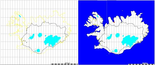
mkgmap now has support for sea polygons. This means that when you view a map generated by it the ocean will actually be blue, as opposed to the same color as the land with a small coastline separating the two which was previously the case.
I've updated my daily map export of Iceland to use this feature. Here's a before & after picture taken using QLandKarte:
Discussion
Comment from marscot on 17 September 2009 at 19:37
looks great , much better
Comment from Antwelm on 17 September 2009 at 21:11
Finally! Will become so much easier to navigate when zoomed out...
Comment from Rhubarb on 17 September 2009 at 22:26
Ooooh lovely :)
Thankyou mkgmap!
I'll have to grab the latest mkgmap and use it this evening.
And thanks Ævar Arnfjörð Bjarmason for letting us know about it.