
Imagery coverage map for OSM Philippines
Posted by seav on 22 February 2012 in English. Last updated on 25 February 2012.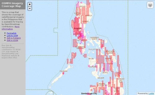
I mentioned in my previous diary entry that I discovered that Bing has added/updated tons of satellite imagery for the Philippines (and apparently also for the rest of the world). This now makes maintaining the catalog of imagery coverage in the Wiki very unwieldy.
So, what I did was to create a simple slippy map to visualize the areas in the Philippines that are covered by Bing and other available imagery.
It's my first time to use CloudMade's Leaflet and I have to say that it's a joy to use. :)
Discussion
Comment from Harry Wood on 24 February 2012 at 16:07
Looks great. Did you have to manually put together these vector boundaries though? or where did you get them from? (The data in the file here: http://forge.codedgraphic.com/osm/imagery_coverage/data.js )
How can we get a better view of what's been added worldwide? There's a discussion here about getting updates in to the bing coverage analyser, but it seems that's going to take a while. So far I haven't seen any map, from bing or otherwise, which gives a good overview of what's been added (I'm aware there's several PDFs which don't give a good overview)
Comment from seav on 25 February 2012 at 00:02
Hi Harry,
These outlines were all compiled manually: basically by tracing the outlines in JOSM then saving the OSM file which is then converted to JSON (data.js).
The dates that you see in the layer control are the dates when the corresponding imagery were discovered by the local community.
I hope Bing would release an update history similar to what Google is doing for Google Earth. But until that happens, we just stumble onto new imagery every now and then.