
Wiki loves monuments - OpenStreetMap, too!
Posted by poppei82 on 8 September 2014 in English. Last updated on 9 September 2014.Hi,
From 1.9. until 30.9. Wikimedia wants to collect nice pictures of cultural heritage. With the Wiki Loves Monuments contest you can win nice prices if your photos show a cultural heritage (building, monument etc.).
But if you go outside, don’t forget OpenStreetMap:
- it will support you in finding the cultural heritage monuments
- you can also add the cultural heritage monuments into the OSM-database
Find cultural heritage
You find the cultural heritage in your local city by browsing the country-specific lists of cultural heritages. For example in the overview of Germany’s cultural heritage lists you can navigate to the cultural heritage list of the city where you want to go to take pictures.
An online Graphic User Interface you’ll find at the Wiki Loves Monuments Map. However the monument lists for Germany are not complete. It seems that they were not found automatically by the Monuments Database-bot. Also there is no possibility to download GPX. Another tool, Panoramap seems to be outdated? I couldn’t see anything on it.
Planning routes (with Univisited or WLM-app (Android))
There is a small Android App that will support you in planning routes: Unvisited. You can set how many kilometres you want to go and how many pictures you want to take. It has a special “Wiki Loves Monuments-mode” that will specially look for cultural heritage. You can also take pictures for other Wikipedia articles. This app only shows locations of articles/monuments where a picture is still missing! However this app uses G-Maps and it is not possible to navigate directly to the monuments.
The Wiki Loves Monuments App is the official app to browse monuments, taking pictures and uploading them directly. However I was not able to do anything with this app…
GPX-export and navigation to monuments + taking pictures (with Osmand (Android))
If you want to do a biketour and take pictures you possibly already use the free and offline usable Osmand for Android smartphones. I will show you how to import cultural heritages and how to navigate to them. As an example I will describe the following steps for Bad Sobernheim, a small town in Rhineland-Palatinate/Germany.
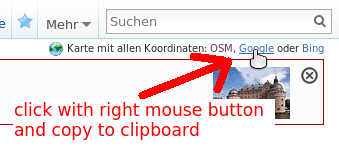
- Open list of cultural heritages for your city, e. g. Bad Sobernheim
- Click on “Google” link with right mouse button and copy the link to your clipboard. For German Wikipedia in the upper right corner:
and for English Wikipedia near the References-header. Click on “show” where you find the direct download-link to gpx-file (you can go to step 5):
Other Wikipedias: If your Wikipedia has no links in the upper right corner, you can use kmlexport directly. You have to define the project language (NL, DE, CS, EN, …) and the article-name. Syntax: https://tools.wmflabs.org/kmlexport?project=LANGUAGE&article=NAME_OF_ARTICLE. See example in the comments. - a) Open a new tab or window in your browser and insert the copied link. Delete “&redir=google” from adress and hit Enter. The kml-File will be downloaded. Rename the file to XYZ.kml

b) You can use KML to GPX converter, where you can directly paste the downloadlink for kml-file. An Osmand-GPX-file will be downloaded. You can go to step 5.
PLEASE NOTE: This downloads ALL knowing locations of monuments! I don’t know how to download locations of missing pictures ONLY. The mentioned Unvisited-App is doing so but I do not know how to download this gpx. Any hints? - Since version 1.8 of Osmand it should be possible to import kml-files directly However in my test it wasn’t possible. So maybe it is necessary to convert the kml-File into a gpx-File. You can use e. g. KML2GPX online tool or the converter mentioned in 3 b) for this purpose.
- Copy the kml- and/or gpx-File to your smartphone and open it with Osmand. Perhaps you need a file manager to find the file on your phone.
- You will see the monuments as an overlay on the Osmand-Map. If you have never used Osmand before, you should download the map for your country first. Tap on a red position marker for about one second, then additional information will appear on the screen (name of the monument as it was in the Wikipedia-table).
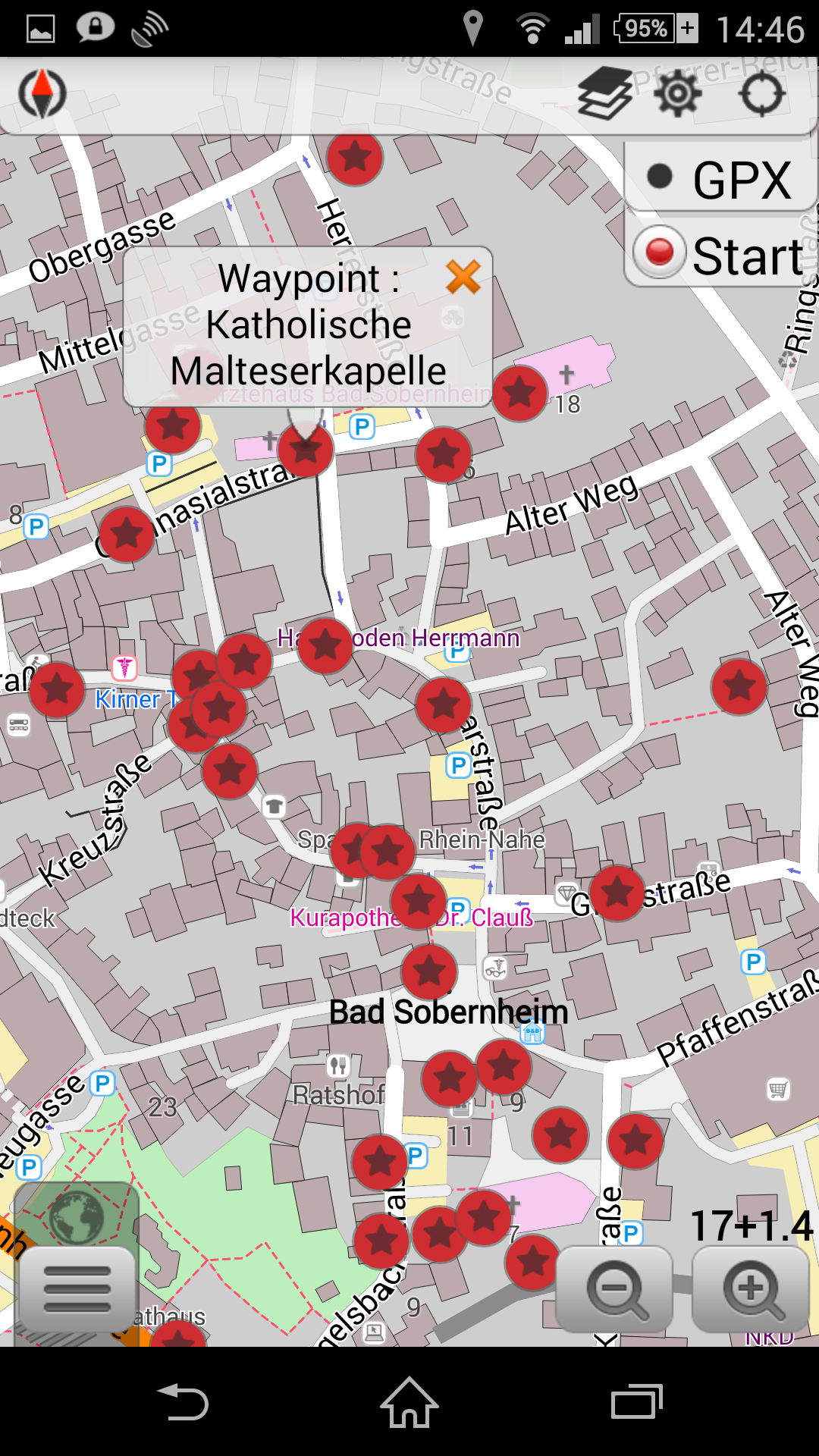 Tap shortly on this information, then a menu appears where you can navigate directly to the monument or taking a picture.
- You find the pictures in your osmand-directory on your phone in the subdirectory “avnotes”. You have to rename them properly and upload them to Wiki commons using the WLM-Upload-agent or the Wikimedia Commons App
Mapping monuments for Historical Map
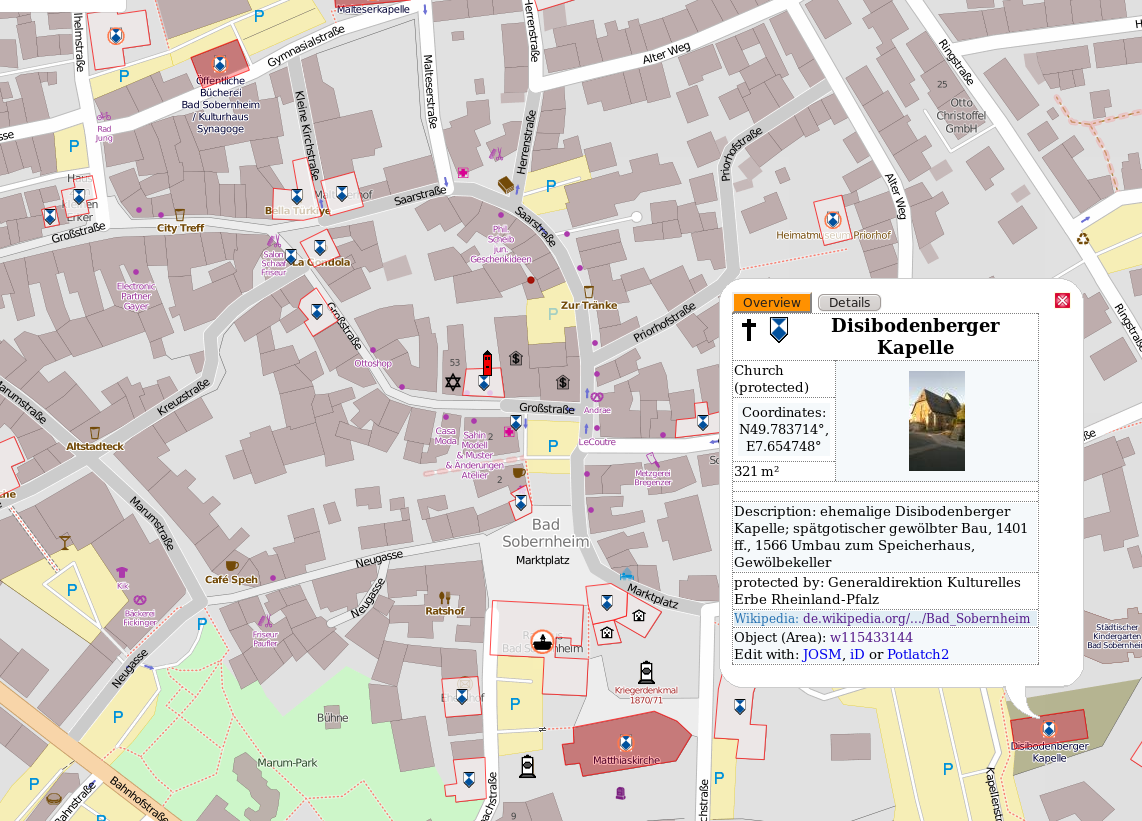
After your visit of the cultural heritage monument you have local knowledge that you can also contribute to the OpenStreetMap database (perhaps you also did a gps-track using Osmand). Then this heritage-object will appear on the great Map of Historical Objects.
You find the explanation on how to map Historical Objects on the Wiki-page. Keep in mind that there is a nice JOSM-preset with which it is very easy to map such objects. With the optional Heritage-Preset you can add additional heritage-specific information on the objects.
PLEASE NOTE: Only map objects that are listed in the cultural heritage lists, please. Do not map any monuments which are not of heritage importance.
PLEASE NOTE: if applicable, add the Wikidata, WikiCommons or Wikipedia-links. See comments.
Wishes for the future
You see that it is a little bit complicated to combine the two great open projects: driving around to do some mapping and parallely saving the cultural heritage for the upcoming generations. In my eyes it is a waste of the crowds’ power if only one thing is done though an open minded human is once a time on a place and wants to contribute to both projects.
So I think we need a little support by a specialized app (that is perhaps a plugin for Osmand):
- show cultural heritage as an overlay
- optionally only show cultural heritage and / or Wikipedia-articles which still needs pictures
- being able to directly navigate to monuments
- optionally plan routes like Univisted-app
- optionally: “alarm-mode” where the phone rings if you are in the neighbourhood of a monument, so that you can take a picture of it and map it
- direct Upload-interface to Wikimedia Commons (automatically rename picture-files)
- directly categorize pictures in Wikimedia Commons
- directly edit the Wikipedia-page and add picture automatically
- ability to add monument to OSM-database. Perhaps using the nice Vespucci app with Historical Objects preset?
- Wikidata integration…
Discussion
Comment from Sanderd17 on 8 September 2014 at 16:53
That Google trick you show depends on the language of the article. F.e., the Dutch WP doesn’t have such buttons (see http://nl.wikipedia.org/wiki/Lijst_van_onroerend_erfgoed_in_Alveringem as example).
Nice overview for the rest ;)
Comment from poppei82 on 8 September 2014 at 18:19
Hi!
I live directly at the Dutch border so that I very often take pictures in the Netherlands. Here’s the workaround for the Dutch people (I also updated the blogentry):
See http://tools.wmflabs.org/kmlexport/ for more information. You can export all coordinates given in any article. You have to define the project language (NL, DE, CS, EN, …) and the article.
So your link to kml-File is: https://tools.wmflabs.org/kmlexport?project=nl&article=Lijst_van_onroerend_erfgoed_in_Alveringem
Have fun. :-)
Comment from stragu on 9 September 2014 at 03:35
Brilliant, thanks for the tips! :)
Comment from pigsonthewing on 9 September 2014 at 10:13
When you add a monument to OSM, please don’t forget to tag it with the relevant Wikidata ID/ Wikipedia article title/ Wikimedia Commons category (or image link), if applicable:
http://wiki.openstreetmap.org/wiki/Key:wikidata
http://wiki.openstreetmap.org/wiki/Key:wikipedia
http://wiki.openstreetmap.org/wiki/Key:wikimedia_commons
(If there’s a Wikidata ID, the other two are probably redundant)
Comment from pigsonthewing on 9 September 2014 at 10:22
You’ve shown people how to download KML files, but the interface illustrated is for the German-language Wikipedia.
On the English-language Wikipedia, many articles have a template, which includes a link to download the KML.
For instance, on:
https://en.wikipedia.org/wiki/Scheduled_Monuments_in_Birmingham
just near the “References” header, is a box labelled “Map of all coordinates from Google”. click “Show” for the KML download link.
On articles with lists of coordinates, where the template is not present, edit the article and add {{KML}}
Comment from poppei82 on 9 September 2014 at 10:49
Thanks for hints, I updated the blogentry. Poppei
Comment from escada on 10 September 2014 at 16:10
While I’ve been adding Monuments to OSM myself, I wonder whether I can use the data found on Wikipedia. In Belgium, there are two types of “Erfgoed”, the ones that are heritage and the others that are just listed, but not protected. While in many cases, the buildings that are heritage will have a blue/white sign [1] not all of them do so. The ones that are just listed cannot be verified on the site. So I cannot map the “ground truth”. Does this mean than I am importing then? Do I violate the license in that case (even when I visited the building) ?
Just wondering and wishing this license stuff was not so complicated and confusing.
[1] http://nl.wikipedia.org/wiki/Monument_(erfgoed)#mediaviewer/File:Blauwschildje_-Unknown-20413283-_RCE.jpg
Comment from poppei82 on 13 September 2014 at 09:50
That was already one of my questions that came in my mind: is this legal, that I was led by wikipedia (non odbl-compatible license) to this building? But nobody could answer the question. So I developed this way, how Osmand helps me navigating to this buildings… because nobody told something against this; I hope that this is OK.
As I rememeber you understand German: question: http://forum.openstreetmap.org/viewtopic.php?pid=344118#p344118 and the answer is two posts further.
However I do not know the situation in Belgium. Maybe ask someone in the Erfgoed-Wikipedia project?
One additional thought: you know wikidata? The license is CC-0 there. I think that coordinates are included there also. So this is compatible…
Also very often the street and housenumber of the building is given (in the official heritage lists). This should be OK to usw to navigate to the building (although you see no Blauschwildje there). In Germany (Rhineland-Palatinate) I have never seen such a sign at monuments. Here in Northrhine-Westfalia some buildings have this.
Poppei
Comment from escada on 13 September 2014 at 11:23
Thank you for your answer. Somehow it is comforting that other struggle with the same problem. Since the Flemish government has released the data under some public license, I’ll assume I can just keep on adding the data.
Comment from ydrgbjo on 21 September 2014 at 10:41
Interesting article about historical monuments.
Have tried it here in Bern: http://geschichtskarten.openstreetmap.de/historische_objekte/translate/en/index-en.html?zoom=13&lat=46.95663&lon=7.39392&layers=B00000000FFFFFFTFFTFT On osm.org: http://osm.org/go/0CZavZX Quality assurance tool by Simon: http://qa.poole.ch/?osm_id=-1682378
In general it seems to work. One little exception: amenity=place_of_worship we use here to mark place of any kind of religious community and not for historic religious buildings only. Thus, it might be misleading here in Bern.
Beside of that, we work with KGS-Nr. lists published in wikipedia (Example): https://de.wikipedia.org/wiki/Liste_der_Kulturg%C3%BCter_in_Bern/Innere_Stadt_%28Ost%29
So for cultural or historic buildings or monuments in Bern you may find often tags as: ref:kgs wikipedia wikidata image
As an example the Swiss National Library: https://www.openstreetmap.org/way/40859920#map=19/46.94133/7.44975
Anyhow, keep up with your good work.
cheeers, h