
Ashgabat's Boroughs Reduced to Four, New Boundaries Need to be Drawn
Posted by apm-wa on 29 January 2018 in English.Here comes another project for me, drawing boundaries of the four boroughs of greater Ashgabat:
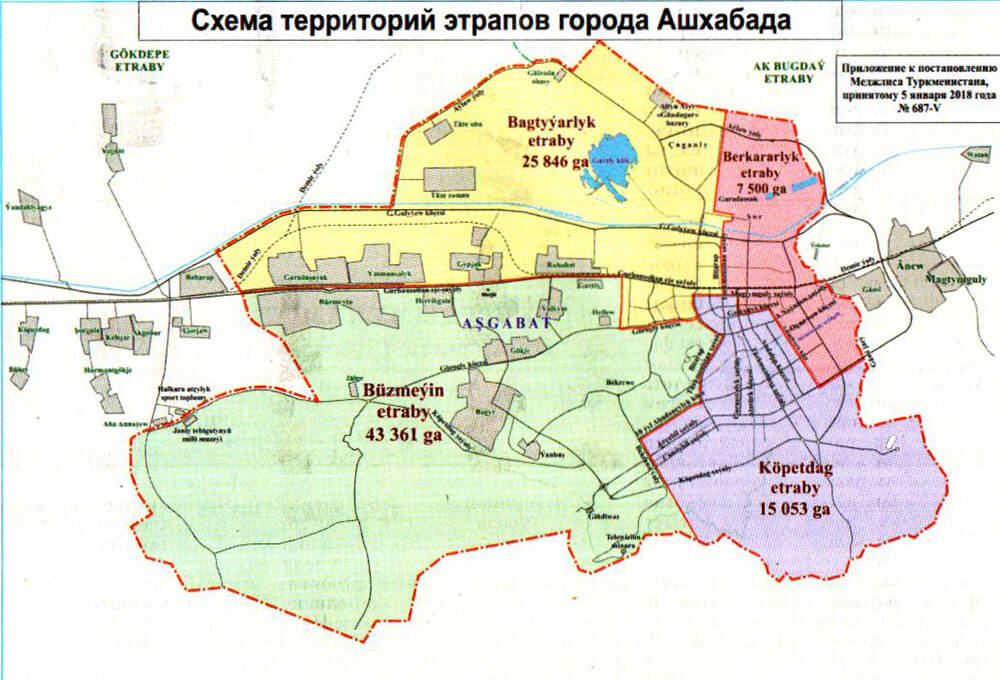
While at it, I will update the municipal boundary as well. This will take some time, so please be patient!
Discussion
Comment from apm-wa on 29 January 2018 at 16:39
Started tonight on Büzmeýin etrap, the largest of the four. Mostly done but will need some tweaking. Next I will tackle Bagtyýarlyk etrap. I redrew the boundaries of the suburb/neighborhood/former town of Büzmeýin (previously known as Abadan). More work ahead to get this all updated.
Comment from apm-wa on 30 January 2018 at 17:52
Finished a rough draw of Bagtyyarlyk etrap, the second largest (northwest quadrant). Power went out about halfway through so had to way for the lights to come back on before I could finish!
Comment from Claudius Henrichs on 1 February 2018 at 09:49
Is the above map scan the only source you have for the boundaries? Or are you consolidating previous boundary data that were already present in OSM data? I assume there’s not really an “Open Data” approach anywhere within the Ashgabat administration…
Comment from apm-wa on 2 February 2018 at 18:33
Yes, Claudius, that is the only source available for the boundaries. There were no previous data on borough boundaries in OSM. There is in OSM a boundary for the city that appears to be arbitrary and does not correspond to the map scan, which is authoritative since it is an annex to a decree of the national parliament. When done with the borough boundaries, I will correct the existing city limit boundary to correspond to the parliamentary decree.
No, there is no “Open Data” approach in Turkmenistan. This is a closed police state and such data are not shared with the public.
Just finished the Kopetdag etrap. One more to go. The boundaries outside the urban area (where there are streets) are rough estimates and may be subject to correction if and when more data come available.
Comment from apm-wa on 3 February 2018 at 04:56
More or less have finished the fourth etrap, Berkararlyk. The outer boundaries on all four are approximations based on the map above. Lacking definitive landmarks I have roughed in those outer boundaries. If anyone else wants to take a stab at refining them, please do! The ones along streets in the more central parts of the city are pretty good, I think, since I can identify which streets form those boundaries.
This map also provides authoritative boundaries for villages annexed into the city of Ashgabat, and that’s the next project, after fixing the overall city limit.
Comment from apm-wa on 3 February 2018 at 15:24
I have matched the Ashgabat city limit to the outer boundaries of the four boroughs (uly etraplar) of Ashgabat. Due to the lack of identifiable markers on the map above, the outer boundaries and the city limit are best guesses and subject to correction in the event better data is made available. It is in any event more accurate than the former city limit, and encompasses all the former villages annexed in 2010.