
Don't Mention the War
Posted by alexkemp on 5 June 2016 in English. Last updated on 8 February 2019.Friday 3 June was spent surveying Norman & Morley Roads, both off Porchester Road, Nottingham NG3, and the previous days in the week were spent surveying Forester Road & Cherrywood Gardens + Porchester Road itself.
I live in NG3 but these lands are more foreign to me, since they are within the Gedling council district (my local council is Nottingham town). It is only a kilometre or so away from my home, yet feels very different. One immediate (and welcome) difference is that the signposts each have their postcode upon them. Very useful.

I also make use of the postcode lookup provided by Raggedred.net. The following URL added within Preferences (menu:Edit|Preferences|WMS/TMS) gives the postcode within each centroid within JOSM:
tms:http://www.raggedred.net/tiles/codepoint/{zoom}/{x}/{y}.png
Let’s first make a brief roundup of some new facts that were revealed when Martyn Fretwell posted a link to his blog in a comment to my diary entry on the NSR part 3. Martyn is obsessed with bricks, and his blog-entry had some very useful facts for streets that I had surveyed:—
- 1850: Abolition of the Brick Tax
Production of bricks (and thus English homes built with those bricks) began to go through the roof (awful pun intended). - Burgass Road, Porchester Road
Named after William Burgass (together with Edward Gripper, joint Managing Directors at the foundation in 1867 of the Nottingham Patent Brick Co. (NPBC)). Burgass Road was the access road into the Thorneywood Brickworks (it is the vertical road at bottom-right in the 1938 picture below; notice also the railway track that runs to the left of the road, and terminated in the Works at the Engine House, and below at the NSR Thorneywood Station on Porchester Road)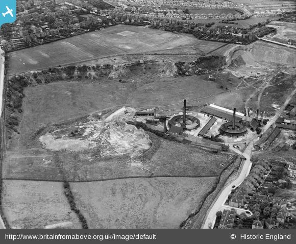
- Bennett Street, Woodborough Road
This was named after Charles Bennett, who started as foreman of a yard & ended as NPBC Works Manager. Charles built himself a house at 752 Woodborough Road (now a set of 3 flats, and positioned on the corner of Bennett Street) and also Brick Makers Cottages (756-786 Woodborough Road, and thought to be designed by T.C Hine - they are delightful buildings). Both Bennett Street & the Cottages were directly opposite the Mapperley Brickworks, also called the NPBC Middle Yard.
Back now to last weeks’s surveying:—
Some of the buildings in Forester Road had house-names with dates:

Some of those buildings were very much newer, and then the peculiarity of some numbers just missing altogether from the street. It took until Friday & Morley Street until a local chap confirmed my suspicions; houses were missing/rebuilt because the Luftwaffe paid a visit in May 1941, and a stick of bombs fell across the area. My home town is Hull & I can promise that Nottingham got off lightly; most of Hull centre & the docks were simply flattened, and the population traumatised.
Of course, the story in parts of Germany is far worse than either English city.
Discussion
Comment from SK53 on 5 June 2016 at 08:27
You’re not the first to come across this phenomenon on the E side of the city: there’s a new house inserted in one of the side roads in Sneinton Elements: see WWII Bombs in Nottingham.
The wikipedia has a useful map of bombed locations:
Comment from alexkemp on 5 June 2016 at 09:20
Hi Jerry
Thanks for the Wikipedia Map; I’ve also read the nottstalgia.com forum that it originally came from. Unfortunately, whilst the map shows Carlton Road (the large road running towards top-right) & the (now discontinued) NSR railway-line (vertical line on right-hand-side) and therefore the bottom of Porchester Road (where the black-line crosses Carlton Road) + Burgass Road (coming off Porchester & running parallel to Carlton Road) the map stops well below my recent surveys. In fact, I cannot yet find any mention of bombing damage in the Morley Road area.
Comment from SK53 on 5 June 2016 at 12:01
Yes, also interesting that a house on Ribblesdale Road (Sherwood N of Valley Road) was bombed. It ought to be possible to pick it out, but many houses have been substantially extended in recent years (when I surveyed it in 2011, there seemed to be builders everywhere).
There ought to be more details of the bombing somewhere: Local Studies Library or Notts Archives perhaps. Both the Nottstalgia thread & Dominic Morrow’s recent blog post about the Nottingham Canal make me intrigued about the location of air raid shelters in WWII.
One other point mentioned in one of your earlier posts was Robert Mellors : I presume this is the same person who wrote “Nottingham Suburbs Now and Then” (e.g., Basford) in the early 1900s.