
Olympic facilities being mapped really good in OpenStreetMap has been a subject of many articles recently, mainly with comparison to Google Maps (which are nearly empty, of course, unlike Yandex Maps). This has been good for OSM awareness, and Russian mappers welcome that. In Russia a lot of Olympics-related projects (including the torch relay) were using OpenStreetMap, and most of them even attributed us correctly.
But there are comments that bug me, which imply that, as it usually happens with humanitarian response, in case of Olympics some mappers just organized themselves on a weekend and mapped the whole area from Bing imagery and probably official data (of which there is none, by the way). That is completely untrue: we had no mapping parties or other events targeted at mapping the region.
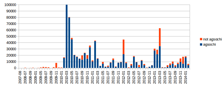
This chart shows number of changes (identified by num_changes XML attribute) for the region containing Sochi, Adler and Krasnaya Polyana. Only small changesets were counted, which do not cover other regions. You can clearly see that the region was mapped mostly by agsochi (83% of all changes) four years ago (with 185K changes in March 2010), and then gradually updated to reflect current situation.
This kind of chart is typical for many regions with active mappers: someone maps everything when they first find the area, and then update it through the years. It just happened that Olympic Games were held in a well-mapped region, not the other way around.
Other contributors with more than 5 thousand changes are:
- Sergey Astakhov — 3.3%
- raw2008 — 2.2%
- garl — 1.4%
- -James- — 1.3%
- ulil — 0.77%
- СПТ Сочи — 0.77%
The last one is notable in that it is an account for Sochi’s fire brigade, which since April 2013 has been constantly adding hydrants and fire stations in the region. You can see the outcome of their work on OpenFireMap.
Discussion
Comment from Vincent de Phily on 11 February 2014 at 08:42
Very nice and usefull writeup, thanks.
Comment from Mappo on 11 February 2014 at 11:54
Is there no official data at all? I was impressed with the addressing data when people featured Sochi maps and had assumed it was an import from government held data. If not then that’s all the more impressive.
Comment from Frederic B on 13 February 2014 at 06:56
Nice graph. Although your title might be off (correct me if I’m seeing this wrong). I believe Sochi won the Olympic bid somewhere in 2007 so it does makes sense that (a lot of) changes were made exactly because of the Olympics.
Comment from Zverik on 13 February 2014 at 06:58
Frederic, I doubt it. The graph shows that Sochi region was mapped when a very active local mapper appeared. He would have done so whether there was an Olympics or not. Russian press was silent on the topic until around 2012.