
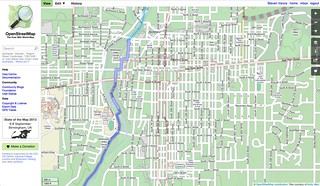
I visited Richmond, Indiana, in early August with my friend who grew up there. There isn’t much to do there, but there are a lot of neat places to bike to. Richmond had more features mapped than I expected, but I was happy to contribute via Pushpin and JOSM. With Pushpin OSM, an app for iOS, I added a couple of venues I visited, including Firehouse BBQ & Blues.
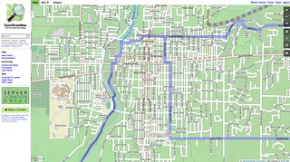
With JOSM, though, I wanted to add the city’s bike routes so they would appear in OpenCycleMap and could then be immediately embedded as a (somewhat) interactive map on the Bike Richmond website. I asked a city planner for a bike map and he gave me a GIS printout that showed the “recommended routes” (which are unsigned) and then he drew on the signed route that augment the recommended routes. The signed route essentially creates a loop.
I tagged all of the recommended routes as “bicycle=designated”. After the tiles in OpenCycleMap updated to include my work in Richmond I realized that OCM doesn’t symbolize “bicycle=designated” unless they’re in a relation. I created a relation, calling it the “City of Richmond Signed Bike Route”.
This was cross-posted to my urban planning blog, Steven Can Plan.
Discussion
Comment from BrookeChea on 20 August 2013 at 14:11
nice!