OpenStreetMap

Sam Wilson's Diary

Recent diary entries

We had another great OSM meetup today in Perth (Western Australia). This time we were in Fremantle, where there’s lots of 19th century buildings that need address data and business information, as well as a fair bit of clearing up confusion about where one building ends and another starts. About eight people came.

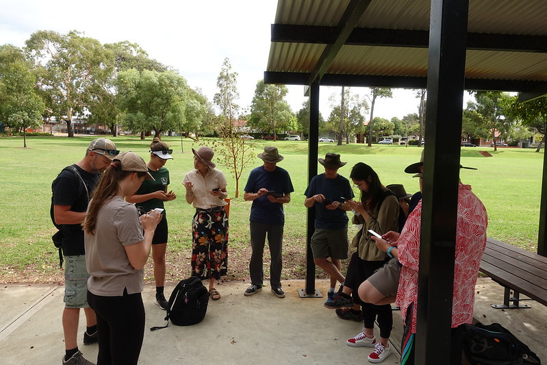
We started in the café, fuelling up with coffees and pastries, and talking about how to map, what to map, and the general semantics of footpaths and roofs.

People sitting at an outdoor café table.

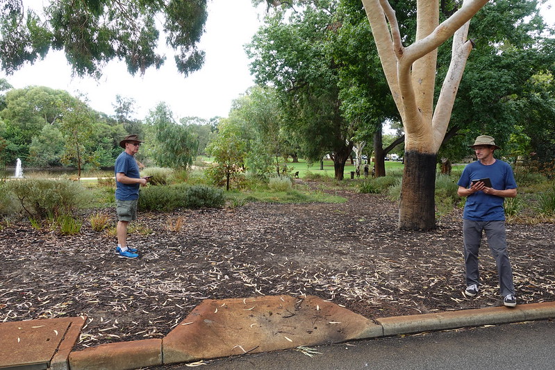
Then we wandered around for an hour and a half or so, splitting into two groups — one went down to the harbour and found lifebuoys, statues, and memorials to seafaring immigrants — the other attempted to add more detail to the University of Notre Dame’s campus, but actually ended up mostly working on addresses, businesses, and trying to make sense of building façades.

Orange lifebuoy at Fremantle Harbour.

The rain came, and we stopped in at the Grumpy Sailor to pick up bagels and take them back to an office space that we have use of. Here the laptops came out and JOSM was fired up.

People editing OSM in an office meeting room.

(This photo was taken a bit late, and a bunch of people had already left.)

It was great to meet some new mappers, and work on some bits of the map together (that still need more work… of course). I even managed to talk to some people on the street about what we were doing! They were “politely interested”.

We’re uploading photos of the day to Category:OSM mapping party, Fremantle July 2022. (Author credits for the above photos are on their pages on Commons; click ‘em for info.)

Location: Fremantle, City of Fremantle, Western Australia, Australia

OSM meetup in Shenton Park

Posted by Sam Wilson on 23 June 2022 in English.

Better late than never — I thought it’d be good to report back on the OSM meetup we had in March this year in Shenton Park.

We had a great turnout, with about a dozen people, many of whom were new mappers. We met at Lake Jualbup, and spent an hour or so sorting out devices, new accounts, and discussion differences between mapping apps. Morning tea (and later, some of lunch) was most generously sponsored by OSGeo Oceania (the Australian OSM chapter).

People standing in a circle with phones.

The group took quite a while to amble around the park, mapping bins, dog poo bags, signs, and figuring out how to map an unmarked but obviously intentional path through a garden.

People in a garden with phones.

Part of the reason for choosing Shenton Park was that it’s at a central point of a few of the Whadjuk Walking Trails, and I’d hoped to head off to record a bit of a distance of one of these. In the end, we didn’t get all that far, because there was lots to map and lots of questions about how to do things. It’s generally slow-going when in a group and when trying to map all the things; it’s somewhat more satisfying than mapping alone, because it is possible to get much better coverage (e.g. all the shops, pedestrian routes, and street furniture).

I have set up a table of the Whadjuk trails on the wiki, so will keep trying to add their relations.

A close-up of a stainless steel trail marker in concrete.

After a couple of hours of mapping, splitting up a bit to spread out more, we stopped by a cafe (and added its details to the map, of course), and took our lunch back to the park. There, we talked about how to organise the next meetup, and what Geogeeks should be.

A week after the Shenton Park meetup, we held a follow-up online mapping discussion (using the OSMF’s BigBlueButton instance). This was a chance to go over the GPS traces and photos that we collected while surveying, and give various demonstrations of mapping in iD and JOSM. It was useful, but I think everyone agreed that doing things in person and outside is more fun!

Location: Shenton Park, City of Subiaco, Western Australia, Australia

Table placard.

This morning was our first (ever?!) OpenStreetMap meetup in Perth, Western Australia. Six of us turned up at the Goods Shed cafe (near the railway station) for introductions, coffee, and a general figuring-out of a plan. Then we headed off in small groups around the local area, mapping footpaths, shops, businesses, trees, drinking fountains, and everything else we could find.

Group photo.

There was lots missing from the map, and we didn’t get to add quite everything… but we did pretty good I think! It’s always hard to add urban areas like this, especially with things like house numbers (which never seem very well advertised on shop-fronts). We divided up into ‘themes’, so that we didn’t clobber each other’s edits (some did shops, some footpaths, some trees, etc.), and that worked really well. Things that didn’t work as good: most of us weren’t so sure about mapping on iOS; the heat was verging on too much (~35°C); and the ground we were covering wasn’t good for demonstrating other types of mapping (such as relations for longer named walking routes).

After a few hours mapping, we reconvened for lunch at Typica. Hopefully the next event will be in a month or so, and perhaps we’ll look at doing something online so we can all share other skills about desktop editing.

If anyone’s interested in joining in, we’re mainly communicating on the Geogeeks Slack channel.

Location: Claremont, Town of Claremont, Western Australia, 6010, Australia

Logo banner

The FOSS4G SotM Oceania Perth Hub conference program has just been announced, with a few things about OSM (including a small talk by me, but I’m not promising anything amazing!). The bit I’m most excited about is an OSM workshop all day on Saturday the 13th: everyone should come along, with laptops, cameras, and GPSs (or just a phone), and learn to edit the map!

Location: Perth, City of Perth, Western Australia, 6000, Australia

New maxspeed for Fremantle

Posted by Sam Wilson on 30 July 2021 in English.

The City of Fremantle has new speed limits, mostly 40km/h. I’ve been trying to get the map up to date. They provide a bit of a map (archive), and I’m checking against the new signs as they go up. I don’t know why they don’t care about what happens west or north of the railway line.

I normally don’t really care about vehicle speed limits, because I don’t drive, but this was an interesting exercise in JOSM filters and non-geometric mapping.

Location: Fremantle, City of Fremantle, Western Australia, Australia

OsmAnd swag

Posted by Sam Wilson on 19 August 2020 in English.

The other day I received a cool new t-shirt and sticker, from OsmAnd. This really is my favourite bit of software on my phone, I think. For about the last five years, I’ve not used any other mapping or navigation app, even when travelling far away places (and even when there’s not actually that much data on the map!).

Photo of my new t-shirt.

The GPS and camera and the things I use when mapping, along with a spiral-bound notebook with a pen stuck in it.

(The location of this post is not actually where I am while writing it, but it’s the last hill I mapped and feels like a good place to fly the OsmAnd flag.)

Location: Coogee, City Of Cockburn, Western Australia, Australia

Spam diary entries

Posted by Sam Wilson on 1 May 2019 in English.

Gosh, the spammers are going for it at the moment on the OSM diaries. :-(

Thank you to everyone who’s handling the deleting of it!

Unfortunately, my feed reader sucks all the bogus entries in before they’re deleted, so I’ve got hundreds of Chinese spam posts (marked as Bengali for some reason), drowning out the interesting stuff. I’d switch to just the English feed, but am getting things via https://blogs.openstreetmap.org/atom.xml so there’s no option for that, and I don’t want to miss the other syndicated blog posts.

Maybe I should just head outside with a GPS… :-)

Notes are brilliant

Posted by Sam Wilson on 5 June 2018 in English.

I’ve been enjoying the Notes features of OsmAnd, both for adding new ones and even more for finding nearby ones when I’m out and about. Every OSMer should tell all their friends to lodge notes! :-) I’ve been training everyone I can (two people so far; maybe I need more friends).

I also only recently noticed that people near where I live are actually leaving notes (they weren’t last time I looked a year or two ago.) Which is great, and I’m trying to fix them all. Many seem to come from MAPS.ME, and sometimes are in the wrong spots or are spurious (most commonly saying a thing is gone when it’s not). But more are useful than aren’t.

So I’ve added the RSS feed of notes for this area to my normal daily news aggregator, and hopefully will do a better job of keeping up to date with people’s corrections and spam.

Location: West End, Fremantle, City of Fremantle, Western Australia, Australia

158 bus route from Fremantle to Perth

Posted by Sam Wilson on 10 November 2017 in English.

I’ve been out mapping the 158 bus route to Perth. It’s not as easy as I’d hoped. Hard to get every stop! Harder still to get their numbers (although, I’m not sure how useful those are anyway).

I’ll attempt to add some more, and keep track of them on the Perth wiki page.

[Photo, all photos]

Location: Perth, City of Perth, Western Australia, 6000, Australia

The Main Roads department of Western Australian recently released quite a few datasets under the Creative Commons Attribution licence. We have explicit permission to use two of these in OSM: the Road Network (MRWA-514) and Road Hierarchy (MRWA-515).

I’m part of a local geogeeks group that meets fortnightly in Perth, and with the help of some people far more knowledgeable than me about spatial stuff I’ve been attempting to derive a comparison between the Main Roads data and what’s already in OSM. That’s a work in progress (eventually it’ll spit out an OSM file containing only correctly-attributed roads that are missing from OSM), but for the time being I’m going down a much more manual route:

1. Download shapefile from the data.wa.gov.au site linked above

2. Use ogr2osm to convert it to OSM format:

python ogr2osm.py RoadNetworkMRWA_514/RoadNetworkMRWA_514_1.shp -o mrwa514.osm`

3. Create a JOSM style file that makes the names stand out:

way[cwy=Single] {
text: auto;
width: 3;
color: #c0c0c0;
text: "road_name";
text-position: line;
text-offset: 14;
font-size: 16;
font-color: lightyellow;
}

4. Mostly, road geometry is actually already in OSM, but the names and road types aren’t. To make it easier to find where to work, I apply filters in JOSM to hide everything apart from roads with no names. Then it’s just a matter of clicking a road, adding its info, and as soon as it’s got a name it disappears (thanks to the filter).

This is still pretty slow, but it’s safe. I’m sure there’s going to be lots of better ways to work with this, but at least some missing names (and geometries) are being fixed.

I’ll use source:name=Main Roads Western Australia to designate where the name has come from. The geometries I’m double-checking against Bing.

Location: Perth, City of Perth, Western Australia, 6000, Australia

Mapping while travelling

Posted by Sam Wilson on 25 April 2016 in English.

I’m on the move at the moment, currently in Spain visiting Menorca and Mallorca, and have been using OsmAnd on my phone a lot. It’s a great program! Especially the bus stops and routes. I just want to say thank you to everyone who’s mapped these things; it really is worth it! And using OSM data in this way has given me more enthusiasm for contributing more transport data in my home town.

The only drama I’ve had with OsmAnd is the GPX-recording, and really that was my fault. For some reason I thought I’d hit ‘stop recording’ before ‘save’… and lost my whole day’s travels. Still, at the least the photos I was taking were safely geocoded (and now on Flickr). From now on I’m going to stick to my trusty old Garmin Vista HCx and proper camera.

I’ve made some small edits to the map, and will try to do more. There’s one bit that I’m not sure about, that I shall leave to mappers more au fait with the area than me; I’ve left a note for that.

I did add my grandparent’s old house, Ca’n Ding Ding (nice name eh?)—

Cassa Ding Ding

Location: Hàbitat, Port de Pollença, Pollença, Serra de Tramuntana, Balearic Islands, 07470, Spain

I went for a walk yesterday, to see what I could see: Trace

I was not stopped by this sentry (‘though she was about 100 mm long so I did duck off around the other side of the shrub):

Spider

And carried on to map this lovely bit of path:

Path

A while later I found that Cockburn Road has been temporarily realigned while it’s being improved (should at least be a tiny bit safer to cycle along once it’s all done).

There are a few new roads being built in this area, so I’ve added stubs for these on the maps pending someone getting in there with a GPS at some point.

Reinforcement Parade

The rest of my photos are on Flickr (and are geocoded, for easier browsing for later verification of any edits).

Location: South Beach, North Coogee, City Of Cockburn, Western Australia, 6162, Australia

I don’t suppose it’s of use to many people, but in the interests of adding to the list (somewhere) of software-that-supports-OSM, here’s one more: http://samwilson.id.au/2015/07/23/tabulate/

Or on the WordPress plugin directory: https://wordpress.org/plugins/tabulate/

Location: Beaconsfield, City of Fremantle, Western Australia, Australia

Finding a small bit of an old railway line

Posted by Sam Wilson on 2 January 2014 in English. Last updated on 4 January 2014.

I didn’t know it when I went out this morning that I was on an expedition to find the old Spearwood railway junction. (Isn’t that the whole point of this sort of ramble though? Not knowing. Although, it’d be nice to know what’s not known in OSM I guess…)

On the way, I filled in a few more street names, and took some more photos of market gardens that are almost certainly soon to be “redeveloped” and never seen any more. A nice morning, and far better than being at work. (Ha! A whole nother week to go yet of the hols!)

The northern part of the walk was reasonably dull (by which I do not mean to imply that it was not enjoyable, just not interesting; dull walks are sometimes the most fun… if you see what I mean? Xavier de Maistre would get it perhaps. But then again, perhaps not.) There was a leaky footpath though.

(Who else takes photos of bus-stop poles, by the way? OSM people only, I assume.)

Once the prospect of a railway formation was gained, however, that old excitement came, that thing of I’ll-just-see-where-this-goes. I did meet a few morning walkers, some with dogs and some old and seemingly deaf to my attempted salutations. One chap on his front lawn attempted to glare me out of his street, but I grew bold (for once; meandering with GPS and camera often feels a bit conspicuous) and took a photo of the building site opposite his house.

After crossing Spearwood Avenue things changed — visibly, but just as much in that vibe that really determines what any place is like. Few well-tended gardens; a tinted 4WD that stopped to watch my progress along the footpath; more fly-tipping… but then, a gravel path with the distinct feeling of being curvacious and level enough to have once been a railway line. A nice thing to think, even if I’d been quite wrong (it was more likely, I thought, to be the easement of some UG asset). Last time I came this way, I went off-track a couple of kilometers following the gas pipe when I was trying to follow the oil pipe…

I assume someone out there knows (much) more than me about the history of this little bit of railway line, but I don’t know where to look.

Anyway, here are some incredibly boring photos of street signs in Spearwood:

http://www.flickr.com/photos/freosam/sets/72157639301543813/

Location: Spearwood, City Of Cockburn, Western Australia, 6163, Australia

Not-very-useful GPS traces

Posted by Sam Wilson on 13 May 2013 in English.

I think there must be a very large number of GPS trace points at the intersection of the equator at the prime meridian (what’s that place called anyway?).

I’m afraid I’ve been fool enough to add quite a few of these myself! Oops. Sorry.

I’ve modified one of the gpsbable scripts that I use to prepare NMEA files, chopping out anything around (0,0), so all should be fine from now on.

Location: 0,000, 0,000

57 weeks of vehicle movements

Posted by Sam Wilson on 3 November 2011 in English.

A bit over a year ago I started uploading weekly dumps of the GPS traces from my company's fleet. I've uploaded a bit over half a gigabyte of data since then, or 20,000 to 50,000 points per week, and party render thinks it looks like this:

File:57 weeks of vehicle tracking.samwilson.png

python render.py -d .. -g none -r 1000 --pos=-32.901318,117.776609

I trace over bits and pieces now and then, but I'm not doing much. I was just wondering whether anyone else is mapping in rural Western Australia and finding these traces useful?

Location: Tincurrin, Shire Of Wickepin, Western Australia, Australia

Lots of GPS traces!

Posted by Sam Wilson on 22 October 2010 in English.

I have recently been given permission from the company that I work for to upload the GPS traces from our fleet of vehicles. These are twenty or so trucks and 4WDs that travel the length and breadth of the south-west of Western Australia, often along small roads and farm tracks, etc. They each have a GPS tracker taking readings at 30s intervals and sending these (when possible; there's a delay when out of range) back to a central server via the GSM network.

I get hold of these traces as week-by-week NMEA files (containing all vehicles' data), and convert them to GPX with this gpsbabel command. Then I upload them. They're about 15000-20000 points each.

I'm going to try to get the sampling frequency increased, because there's lots of areas for which these points are too far apart. Although, I guess as the density of points increases (i.e. from multiple trips along the same roads) the topography will become clearer.

Now, the tracing begins! :-) If anyone wants to help....

Location: West End, Fremantle, City of Fremantle, Western Australia, Australia