How I added some vending machines in a Japan city I've never visited
Posted by PanierAvide on 6 August 2017 in English. Last updated on 20 June 2019.Summary (TL;DR)
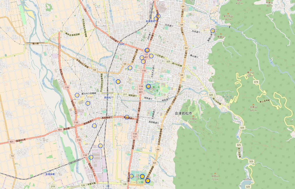
Pic4Carto is a great tool for finding lot of urban features using street-level pictures. I was able to add some vending machines remotely, in Aizu-Wakamatsu (where the next State of the Map 2017 will happen). This map (made with MapContrib) shows all the machines in the city.
Context
You might know that soon the annual OpenStreetMap conference will take place in Aizu-Wakamatsu. As some other lucky mappers, I’m going to this amazing event (thanks to the French OSM association) and give a talk about a tool I’ve made called Pic4Carto. This post is a real-world example of what can be achieved using this tool.
I’ve been last year to Tokyo, it was such an amazing trip. Japanese people and culture are so great. I was amused by the amount of vending machines you can find in the city. Here in France, we have only a few vending machines, and most of them are indoors. So seeing a bunch of machines pretty everywhere was really fun.

As I will talk about Pic4Carto, I thought it would be great to do a real showcase of the tool with these vending machines. But first, what is Pic4Carto ?
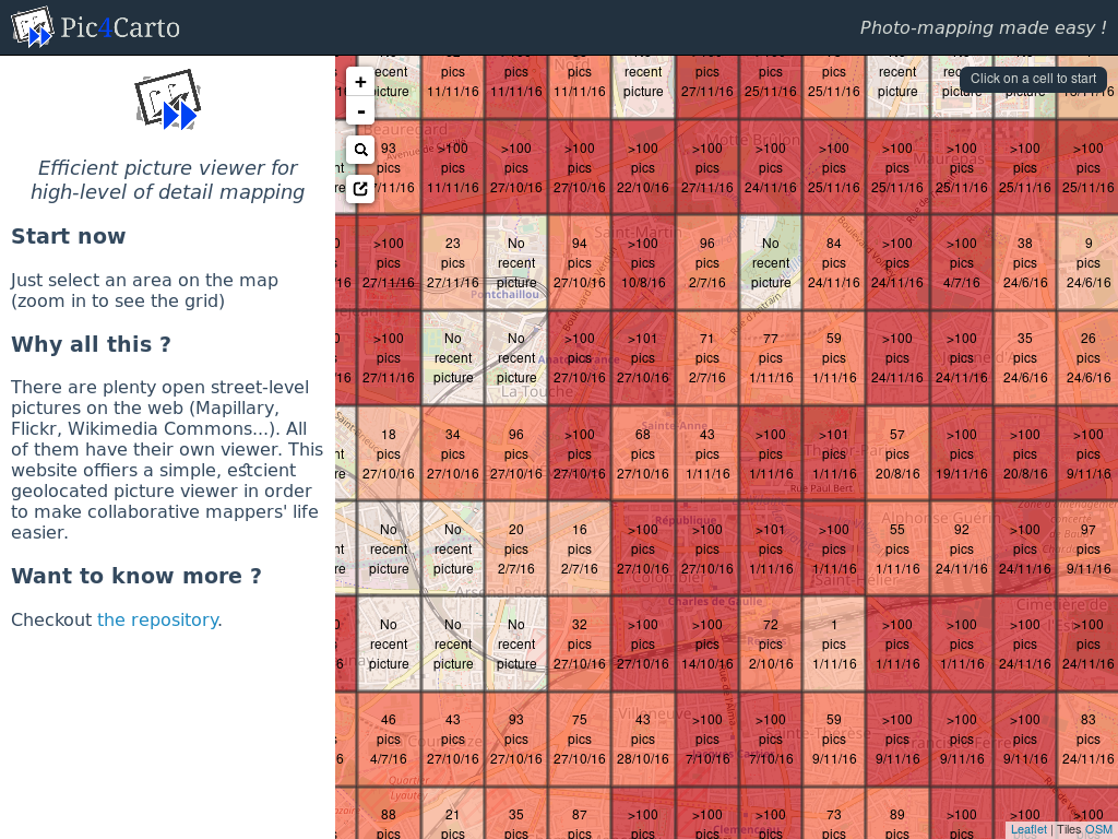
![]()
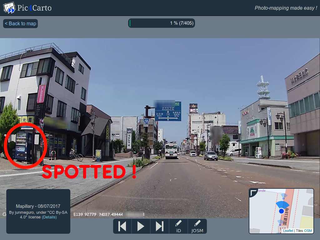
Pic4Carto ( http://projets.pavie.info/pic4carto/ ) is a web viewer of all open-licensed, street-level pictures available online. It was created to make re-use of pictures from Mapillary, OpenStreetCam, Flickr and Wikimedia Commons easier for mapping. In fact, you can easily find on these pictures a lot of urban objects, like fire hydrants, benches, shops, speed signs, and… vending machines !
Add all the vending machines !
So, the idea of the showcase is to see how you can map remotely urban objects using Pic4Carto and other tools like MapCraft. Before I started, there was already some vending machines in Aizu-Wakamatsu. 33 nodes to be precise (thanks Overpass Turbo !).
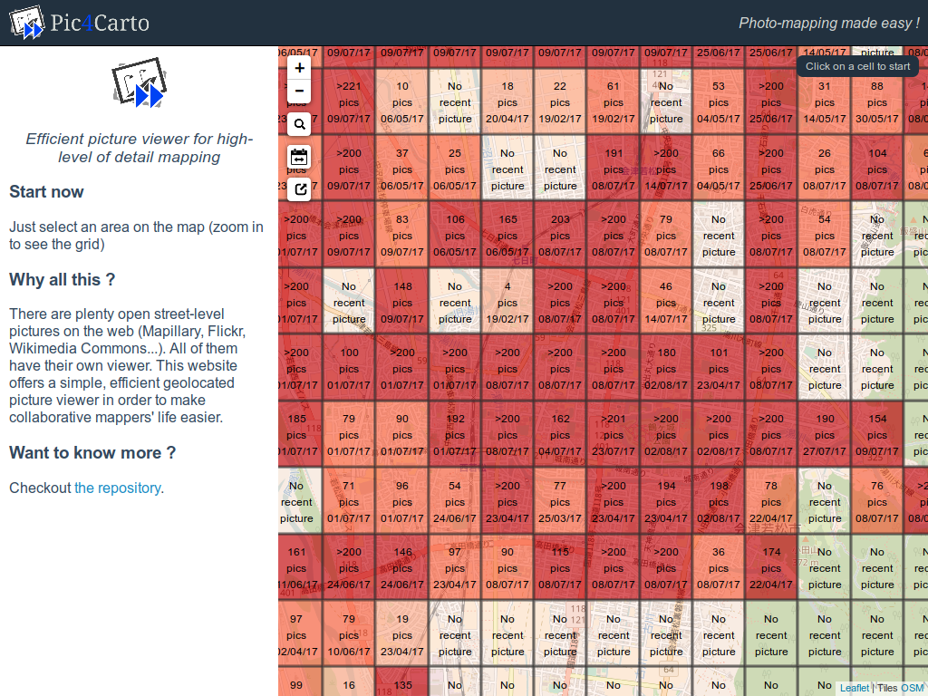
Meanwhile, I can see that there are a lot of recent pictures (last 6 months) using the Pic4Carto main map, which shows picture availability statistics in a city (just wait two seconds for stats to load).
So we’re good to go: a theme, a good source of data, and all the tools ready to do some efficient micro-mapping !
Pic4Carto + MapCraft = <3

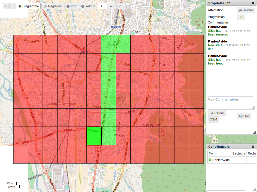
In order to make what I call exhaustive mapping, meaning map all objects in an area using all available pictures, we can use the power of both Pic4Carto and MapCraft. MapCraft is a tool for work in team over an area, as you do in Humanitarian OSM. You provide to the tool a set of geometries, each one will be handled by one contributor.

Good news, you can directly export the Pic4Carto main map grid to use it in MapCraft. Use the export button in the top left corner (see below), and save the grid as “OSM XML” format on your computer.

Then, in MapCraft, you can create your own “Cake”, which is mapping project. Just log-into MapCraft, then you will have the menu “New cake”. There, you have to supply some informations: project name, description, and geometry. The geometry file is the grid we just exported from Pic4Carto.

Then create it, and here you are ! You have your freshly-baked cake ready to use. Here can start the productive work: each one of your team mates can take a slice of the cake, and start mapping over it.
Adding vending machines
Now that all the tools are ready, we can do some productive mapping. As I was working alone on this project, the MapCraft cake is just a way to track which pictures I already have looked at. The process is the following:
- Take a slice of MapCraft cake (set yourself as owner)
- Go back to Pic4Carto, on the same cell
- Watch every picture, and when you see an interesting object, click on the Edit button (either with iD or JOSM)
- Add it on the editor. A good practice is to link the picture to the added object using either mapillary=](https://wiki.openstreetmap.org/wiki/Key:mapillary), [flickr=, wikimedia_commons=](https://wiki.openstreetmap.org/wiki/Key:wikimedia_commons) or [image= tag depending of the picture provider.
- Then watch other pictures, until you’ve done the cell
- Go back in MapCraft, set the progress of the slice to 9 (which is 100%), and remove yourself of owning the cell
Not so hard, eh ? I think it’s a good way to spend time when weather isn’t good in your city, it lets you discover amazing places and improve our database.
Conclusion
So you have wondered that all this can work for pretty any kind of objects: street lanes, benches, traffic signs, shop, amenities, building description… You can use pictures for mapping whatever you like, and it have never been that easy. You can work alone, or in team. You have access simply to all available street pictures of the world.
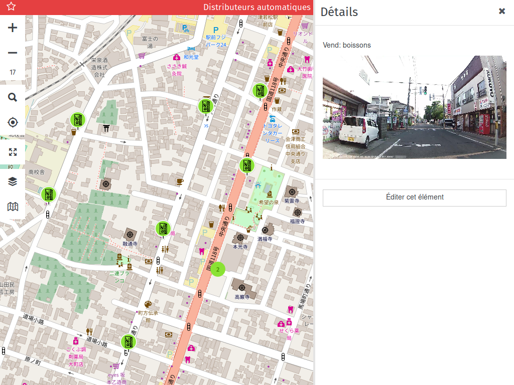
Oh, what about these vending machines ? I created a map showing them (using MapContrib which is a great online editor for new mappers), and you can add the ones you know in your city directly there: https://www.mapcontrib.xyz/t/8a6e32-Vending_machines
I hope that this story was interesting to you, and will inspire you for doing some remote mapping, or uploading pictures to Mapillary or OpenStreetCam ! And if you go to the State of the Map this year, see you soon there ! :-)
Want to go further ?
- Add some vending machines (MapCraft cake, Pic4Carto map)
- Pic4Carto on the wiki
- Pic4Carto.js for web developers
- Pic4Carto API for all developers
- Contact me for questions
Discussion
Comment from pizzaiolo on 6 August 2017 at 18:43
Very nice! Also worthy of mention is the key
[wikimedia_commons](https://wiki.openstreetmap.org/wiki/Key:wikimedia_commons).By the way, do you know of https://tools.wmflabs.org/fist/fist.php ? Hopefully it has free sources P4C can use.
Comment from PanierAvide on 6 August 2017 at 20:25
Thanks for your comment. I added the wikimedia_commons=* tag. I wasn’t aware of the FIST tool, I will look for the listed provider if any could fit for Pic4Carto !
Comment from GOwin on 8 August 2017 at 01:54
Great intro to using street-level imagery for mapping! Thanks for sharing.