
Import of Southeast Alaska Hydrology
Posted by Jfact0ry on 21 June 2019 in English. Last updated on 23 June 2019.Getting Alaska’s National Hydrography Data into OpenStreetMap
The current coastline in OpenStreetMap is lacking in detail for much of Alaska, particularly the very coastal, Southeast Alaska.

Myriad Islands - as they appeared in OSM June 2019 (-136.209, 57.634)
I’d like to use National Hydrography Data to improve the entirety of Southeast Alaska in OpenStreetMap. Here is a side-by-side comparison map that shows current OpenStreetMap data (as of 2019-06-07) with NHD data.
The coastline has been my particular interest ever since I started editing the map.

Before and after photos of Sitka, AK coastline photos from ~2013
In addition to the coastline, the data covers lakes and streams so I hope to include that as well during this import process.
There’s a history of importing NHD into OpenStreetMap, but for Alaska’s coastline it seems untouched by any National Hydrography Data. Recent improvements to Alaska’s hydrography data make now a better time than ever to import data. The Alaska Hydrography Technical Working Group has taken initiative to streamline updating the data for Alaska and making it easily accessible. I had come across hydrology data before and this is a big improvement over previous data for Alaska.
OpenStreetMap’s wiki page on National Hydrography Dataset ultimately discourages imports but I think as far as coastline it will be a huge improvement. It also seems that the data for Alaska is quite good and missing from the map for the most part, so it won’t be a hassle to add features. I aim to use this data to improve much of my surrounding area and I know a few mappers in my area who are highly supportive of this project. I plan on discussing the project with the OSM-imports mailing list.
I will post a diary entry with an update on the project.
2019-06-22 Update:
Update 1: Way Definition
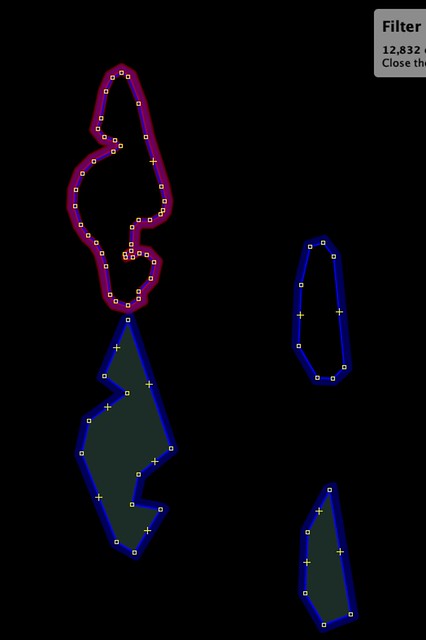
After some deliberation on the way definition, I’ve decided to go with the more defined ways. I intend for this coastline to be left untouched for years to come. If someone were to come across the simplified geometry, they might be inclined to improve it. If I upload the more defined ways, I think that will minimize the likelihood of someone attempting to improve the ways later on.
Here is a photo showing the simplified ways vs. the more defined ways.
As of this moment, the coastline is my first priority and this conclusion I’ve reached concerns only the coastline.
Update 2: Response to feedback
I’ve received feedback that NHD is not that great or the effort involved is not worth it. I would like to respond to this feedback by saying hydrology is an essential component to have in maps if you live in Southeast Alaska.
A good example of the benefits in the map update is this mapped portage route on Chichagof Island. Compare the distance between the two inlets from the previous OpenStreetMap coastline to the NHD coastline.

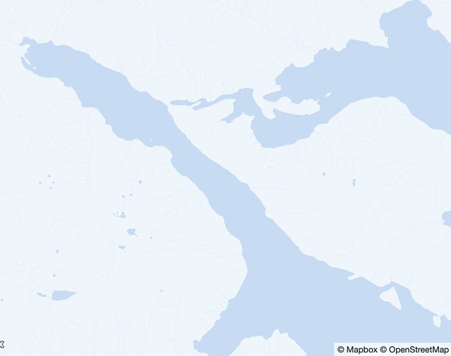
If you used this map to find this portage, you would be left to guess which fork to go down.
Discussion
Comment from imagico on 22 June 2019 at 12:08
There are good reasons why NHD coastal hydrography data has not been imported in a wider fashion into OSM in the past. Many of the feature classes of NHD have no equivalent in the OSM tagging system and therefore cannot be imported without a case-by-case review and new classification. In coastal areas this in particular applies to feature codes 36400 and 53700 but beyond that of course also feature codes 46000 to 46007 where importing as waterway=stream is very often wrong. https://www.openstreetmap.org/way/697889834 for example is not a waterway=stream, it is a waterway=river (hint: if it can be seen on satellite imagery in a densely forested area it is always a river).
Comment from Jfact0ry on 23 June 2019 at 01:45
I made some updates in response to your feedback. Please look at my map comparison I linked to https://jfactory.xyz/maps/hydrology/, I feel like that and my source for the data went overlooked because of your past experience with National Hydrology Datasets.
Comment from Jfact0ry on 23 June 2019 at 01:47
EDIT: typed the link wrong
I made some updates in response to your feedback. Please look at my map comparison I linked to https://jfactory.xyz/maps/hydrography/, I feel like that and my source for the data went overlooked because of your past experience with National Hydrology Datasets.
Comment from yvecai on 23 June 2019 at 11:10
Your comparison uses a simplified coastline from OSM!!! :-)
Comment from Jfact0ry on 23 June 2019 at 21:27
“Your comparison uses a simplified coastline from OSM!!!”
That is totally not the case. What area are you talking about specifically? You might be seeing my recent edits.