
Making a map of the mappers contributing to mapping parties
Posted by Hawkeye on 29 June 2014 in English. Last updated on 30 June 2014.Mapping parties are great fun and it’s nice to show how much work the people involved put in.
Maybe we should have some type of a map to do this easily? Well, there’s some tools out there already see these questions 1 2.
But these solutions don’t quite cut it, and we want a nice customised map. So let’s use the new date/attic data features in Overpass API. Video explaining them here.
So let’s try it, stick this in your web browser:
overpass-api.de/api/interpreter?data=[diff:"2014-06-23T00:00:00Z"];node(55.877838662652906,-4.343075752258301,55.900317043029,-4.297800064086914);out meta;
This gets all the changes made to nodes in that bounding box between 23/06/2014 to the present time. The query returns osm xml file. So just add ‘.osm’ to the end of the file and load this into JOSM or QGIS and were ready to go, right? Nope, the file isn’t a standard .osm file. I couldn’t get it to load in JOSM or QGIS. So no problem. Let’s convert to GeoJSON. Okay, there’s a few ways to do this. OGR2OGR is a command line tool and there’s a few javascript osm to geojson libraries. Great, now we a rocking. Ah, hang on one sec. I found it difficult to make these tools retain the ‘meta’ data - e.g. the userID and name of the user who last modified the feature. And we want the meta data so we can credit people who have made the edits not just show where the edits were made.
I found this tool was easy to download and gave the option for meta data:
http://tyrasd.github.io/osmtogeojson/
Install this at command line:
$ npm install -g osmtogeojson
and try something like:
$ osmtogeojson Anniesland.osm > Anniesland.geojson --flatProperties
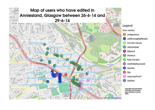
Brilliant. We can now stick the .geojson in QGIS or Tilemill and make a map:
…looks like overpass api can be used for some nifty stuff, maybe animated snapshots by hour or days….go play.
Discussion
Comment from stephan75 on 30 June 2014 at 17:46
Maybe it is possible to do that query directly via http://overpass-turbo.eu ?
Because there you cab export any result as JOSM-ready OSM data with meta data, or directly as geojson, if I am not wrong.
Comment from Hawkeye on 30 June 2014 at 22:14
I don’t think the ‘diff’ command is working in overpass turbo yet. But I’m sure it will be available soon. But yes, it’s possible to get geojson from overpass turbo. But let me know if I’m wrong on these points.
Comment from mmd on 2 July 2014 at 18:40
There’s already a Github ticket out there: https://github.com/tyrasd/overpass-ide/issues/80
Comment from Hawkeye on 2 July 2014 at 18:59
I think the overpass developers are busy updating some of the ‘attic’ data - in the video linked to above, they mention there’s been a problem with some of the older attic data but it’s working correctly for any data since last month but some older data/diffs aren’t quite working.
So I imagine they’ll fix the old attic data and then roll it out to the (more widely used?) overpass turbo system.
Thanks for the update.
Tim
Comment from mmd on 6 July 2014 at 19:19
yes, right. During testing some previously unknown issues were uncovered. Unfortunately, the attic data in the current database cannot be fixed that easily, so a full database rebuild is really needed.
I believe Roland wanted to start this task some time in July, if no other issues pop up until then. Processing a full planet and 2 years of history involves a lot of number crunching and will take quite some time (think ‘a couple of weeks’ rather than ‘a couple of hours’).
overpass turbo is more like a web frontend and has no OSM database on its own. All the data really comes from Overpass API. Basically, Overpass Turbo helps you create your own overpass query, sends that query to Overpass API and eventually renders the result on a map (to put it very simple).
Once the attic data is fixed on Overpass API (this is the server where the database resides), Overpass Turbo can immediately leverage that data without further ado.
hth
Comment from Hawkeye on 6 July 2014 at 22:12
Thanks, I think I understand now. In Overpass Turbo, I used this query:
[diff:”2014-06-23T00:00:00Z”];(node(55.877838662652906,-4.343075752258301,55.900317043029,-4.297800064086914);<;);out meta;
I still couldn’t load the result into JOSM. Instead, exported the result as geojson. So no need to install osmtogeojson as stated above.
So just use overpass turbo and export as geojson.