
New hyper-detailed garden fence mapping in London
Posted by Harry Wood on 18 August 2020 in English. Last updated on 29 November 2021.A few days back I noticed a new patch of hyper-detailed mapping appearing on the London map here near Stroud Green Road, with gardens and garden fences all drawn in. It’s impressive! It looks amazing if you zoom in on that patch:
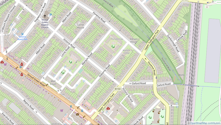
But I felt some frustration when I first saw it, because of the old imbalance of detail issue. I don’t mean to say I’m angry with someone for adding this detail. It’s more a case of being frustrated by an OpenStreetMap problem which we collectively never solved, and I’m frustrated that I can’t actually think of a good solution!
In London for a long time the hyper-detail has mostly been about buildings data. A decade ago as I was organising regular mapping parties, I tried to encourage people to think about building data coverage and to tackle this massive mapping task in something resembling a logical order. Read my diary entry (with coordination animated map) from back in 2010. Back then the default standard style showed buildings a lot more prominently. Dark purply brown, and to quite low zoom levels. Thankfully it was since toned down to a more subtle beige but even so, buildings are very noticeable, and it looks wrong/confusing when patches of buildings appear in sporadic illogically arranged areas. (Maybe this requires a leap of empathy. Imagine for a second, you’re just looking at the map without knowing about how it’s created!)
I think we did quite well at filling in the city centre a while ago. Before that we had major buildings in the city centre missing and yet these random residential estates appearing.
It’s with this problem in mind, that I held back on mapping houses in my neighbourhood for years. Instead, when mapping locally, I focussed on mapping all the shops. These I would map with their buildings because it looks OK (logical!) to have shops showing more prominently than the surroundings.
But I’ve watched residential (i.e. all buildings) data coverage growing. It comes in patches as individuals do their areas. I remember a massive patch to the north of me all got filled out very quickly all at one. That raises an important question about armchair vs survey mapping. Personally I try to do a full addresses survey at the same time as adding residential buildings, but I always assumed that en-masse armchair mapping of London buildings would happen sooner or later regardless of objections. And I assume that was the case for this new north London patch. I’m thinking of Finchley or Barnet or Walthamstow maybe. These places with buildings but not addresses, but…
These days they’re all merging into one mega-patch ….which is what we want! And so it was a couple of years ago that I realised it was time to finally map all the buildings in my neighbourhood, because if I didn’t do it, somebody else would, and I couldn’t have that! But actually (with all the address surveying too) it’s a super slow process, and I haven’t been able to push back my “fully buildinged radius” as far as I would like yet. I do look forward to the day this patch feels more joined up eliminating some of the funny gaps to the south of where I live. With a bit more surveying effort, maybe in a couple of years time my bit of North London is going to look beautifully consistently detailed at last.
…or it would have. But suddenly a few days ago…
So you can see this is not a new problem for me to worry about, and that’s before I mention my 2011 SOTM Denver presentation in which I described the hyper-detail issue in some depth. Partly I added those slides because I was worried I might be boo’ed off the stage by the Americans if I just presented a “surveying good, imports bad” message, but this issue was playing on my mind in relation building coverage and it also relates to crazy hyper-detail coming from tagging ideas and discussions of things like mapping roads as areas. Different, but perhaps part of the same problem. Patches of imbalanced hyper-detail where it feels like we have no hope of “finishing” across a wider area, and which work against (and perhaps render impossible) the aim of achieving consistent balanced map coverage.
I also mention another side to the problem. “it’s a waste of time and energy of the mappers doing it, but It becomes more a problem too when people encourage others (including confused new mappers) to follow their lead”
But I say these things without suggesting a solution. The only idea I had in the direction of a solution was the following:
“This runs quite contrary to the way we’ve celebrated detailed mapping in the past, but perhaps we need to think about a new message. Among our pro-mappers perhaps the message should be: “consider the levels of detail around you”. Don’t go crazy with the levels of detail within your blossom of map coverage. Keep a cap on this and map further afield instead. Go to a level of detail which is realistically attainable by you, or with the help of other mappers, across a wider area.”
But I’m not sure how we would ever engender a new community mapping message like that, even if I could persuade more people that we wanted to. I don’t think it makes sense to be telling anyone off for adding detail. That’s why it’s a problem without a solution as far as I can see.
Anyway I thought the new patch of garden fences was an interesting reminder of that general issue, and it bugs me that this is going to be an ugly imbalanced patch of map I’ll be looking at for years to come now. However there’s a few thoughts which make me feel better about this:
Firstly in the twitter conversation about this, people pointed to Edinburgh where there has been loads of garden fence detail added in recent years. Always inspiring to see people getting on with it and proving it can be done. And what I think they have done well at, is that thing of adding the new detail logically in a centre-going-outwards formation. That feels important to me, thinking from a user perspective. For example a map user may look at the imbalance of detail here asking themselves “why does one side of House O’hill Road have those details, and not the other side?” but zooming out, an answer becomes apparent. Even if we don’t like the missing data, we can see the logic of houses more central within the city having more map data. The coverage is clearly expanding westwards. Looking at the extents of this map detail, you can see that the Edinburgh community have done reasonably well at working outwards from the city centre. Some good coordination. It can be done!
Secondly, it occurs to me actually that the stark difference in detail level my eye is bothered by around Stroud Green Road, is mostly due to missing buildings coverage. It does make me think the gardens mapper should’ve done more of that first but I also realise if I can map more buildings, or if the patch of mega-detail spreads over areas of missing buildings, then the imbalance will be lessened. The garden fences detail makes the map a look a bit different, but when zoomed out it really just shows up as a hint of extra green from the gardens, comparing with buildings-only coverage. Not so imbalanced. It’s motivation to get more buildings mapped!
Thirdly, although we might think of garden fences as a next-level upping the ante on detail level, and naturally part of me is worrying “should I have been surveying to that level of detail all along? Am I going to have to go back and re-do all those houses?” …you can’t actually survey garden fences very well anyway. I suspect the reason this particular kind of detail has suddenly appeared in 2020, is more to do with the bumped up quality of bing imagery we’ve seen this year. I think this means that (when the time comes) I, or somebody else, can reasonably go back to any residential streets I’ve already mapped, and sketch in the garden fences from bing. No need for special surveying. There’s some exceptions to this logic. Places where you can see garden fences on-the-ground, and where mapping them accurately may be significant, but actually I’ve often been mapping them in those kinds of places anyway. e.g I’d put a wall like this to illustrate the pedestrian non-access situation. Maybe it’ll be a big armchair mapping exercise in years to come to even out the coverage of gardens with garden fences.
Discussion
Comment from Paul The Archivist on 18 August 2020 at 23:17
I think part of the problem is a tagging/rendering issue with private household gardens being shown too prominently, in the same way as a public garden (which should be prominent, unlike private gardens).
Fences/walls and also road areas are used on large scale Ordnance Survey maps and I think are worth mapping in OSM to achieve something that is as at least as good. See this area on an old OS map for an example https://maps.nls.uk/geo/explore/#zoom=17.11941827233819&lat=51.56964&lon=-0.11352&layers=173&b=1.
That’s not to say though that it’s not worth trying to ensure the level of detail is balanced across an area, but you have to start somewhere when you want to map in detail. Ideally I think it’s best to start with town/city centres where the main amenities etc are, but if someone wants to add lots of detail to their local area I don’t think this should be discouraged.
Comment from Rovastar on 19 August 2020 at 01:20
I actually noticed that user mapping Shroud Green a couple of weeks ago when they did it. I thought it was great. Sadly, they seem to have stopped now…hopefully they will do more.
I do understand your concerns as it looks a bit of a mess but I think you are far too harsh on people that do this detailed mapping. I’m all for mad detail but it doesn’t mean I’m going to map that detail from my house oiutwards.
You cannot co-ordinated people to map the unique way that you do.
Everyone has different levels of detail that they want to map/think is important.
Some of the most hardcore mappers in the UK have different things they map. I know some that don’t map shops at all (‘they change too much what is point’), and some that don’t map addresses or local buildings near them on the street even (‘someone else can do that I have other things to do, it is boring’), some only really do rural footpaths and field boundaries and no urban area mapping, some just like doing railways, golf courses, etc, etc. I think there is room for all types. Often there is more than enough stuff to map still and we don’t run out of things to do even missing out on whatever you don’t like mapping/think is boring.
I often too have a different approach. I often I tried to map things that a lot of people will go to. So in the past I have armchaired mapped big motorway/major road traffic junctions that should have been circle or oval shaped but where more boxy, corrected the geometry of slip roads and added grass and woodland around, or I have done football stadiums where many people might go, or huge retail parks that had nothing mapped at all (it was not that many years ago I did the OSM wastelands of East London around Beckton that had huge retail parks not mapped and hundreds of thousands of people go there a month) etc.
I find mapping in detail a small residential cul-de-sac in suburbs a bit pointless in compression. That will only get a handful of people going there. But each to their own.
Interesting Harry about how you see the map building up. If I was to plan it like your utopian dream I wouldn’t do it like you. I would have got all of Zone 1 done. I know it took years to get that completed, those areas of marlybone/mayfair have only just been completed. (It was nearly completed what 6 or 7 years ago at my last London pub meetup) And move outwards from there and get all Zone 2 done. I’m not talking houses with numbers as there are roads, footpaths missing, etc. But that just my opinion of in a ideal world how it would be mapped. As it is everyone should just do their thing. I know major mappers that think (or at least thought, maybe I have changed their mind) that mapping buildings with addresses is pointless. I disagree. The vast majority of consumers that see our data are not interested in the address details at all. Think of all the games like Pokémon GO, simulators that want building outlines and have no need for addresses. Or an overview map of an area for a news article they are not going down to all the house numbers.
Maybe we will get there by hand, I know someone who does not mind adding the addresses via a survey but doesn’t like adding the buildings. Maybe it will be easier with an import in the future if we decided for addresses who knows.
Obviously, it would be nice if everything was mapped in super detail there would be a fantastic. Maybe with enough time it would all be done. Maybe it would encourage new mappers in this patchwork map we have. My road is done but the next road across isn’t I will fill in some gaps rather than ‘all my area is complete I will not start mapping. There is nothing to do.’ or ‘none of my area has anything I will not start mapping. It is too much to do.’ Or they have done fences on the next road across, I will map them to my street with the houses already mapped, or Paul The Archivist has done curbs on the next street along I will start mapping those (well I will not be doing kerbs but someone might ;) )
Comment from Harry Wood on 19 August 2020 at 10:15
Yeah it’s hard to talk about this without seeming to criticise the person who came along and added this mega-detail, but I don’t want to do that. I’m very aware that to do so would be completely out-of-whack with any message which has gone before. We as a community have only ever encouraged mega-detail, and also doing in your neighbourhood first.
Makes for an ugly map problem though.
I think you’re absolutely right. My experience is that it’s very difficult to coordinate people to map at all. Even using my influence as the one choosing pub locations and drawing cake diagrams back in the day, I wasn’t actually able to get people to fill in building coverage in the logical centre-going-outwards manner I wanted to see. My pink blobby animation was indeed just a utopian dream (and I knew it would be). Yeah we spread westwards into Mayfair, and left that unfinished for years. That was ugly. I remember.
And yet one of our common counter-arguments is “Why don’t you fill in all of the detail and organise other to help?” like this is an easy thing to do (easier in towns/smaller cities perhaps)
In fact wee have a few common counter-arguments which we use to bat off OpenStreetMap criticism. I’m well versed in these, and also happy to trot them out myself, but I feel like sometimes we’re a bit too deaf to clear problems users have. And maybe users aren’t often good at articulating them, otherwise more OSMers might do more soul-searching on this kind of issue. For example if I were a shopkeeper here on Stroud Green Road looking to put a map on my website, I’d probably say “Weugh! What am I even looking at? Think I’ll go use google maps” and we wouldn’t even get the chance to wisely say to the shopkeeper “Ah yes but why don’t you learn to edit and fill in more gardens fences yourself, or install mapnik and configure it to not show them”.
Comment from Michael Bryant on 19 August 2020 at 10:41
The latter part here feels like something that’s more achievable, and doesn’t rely on people mapping “the right things”. Can we make customising views of the map be more usable/discoverable/intuitive? If I’m the shopkeeper and I want a map, can there be an easy way for me to remove all the gardens, fences, irrelevant house numbers?
Comment from Rovastar on 19 August 2020 at 11:31
Talk about privileged OSM problems to have for the Strood Green shopkeepers! Maybe they should move their business to Woolwich https://www.openstreetmap.org/#map=17/51.49170/0.06662 or Hounslow https://www.openstreetmap.org/#map=17/51.46857/-0.36368 😉 I get it can be annoying as you feel under some imaginary pressure to map to the same detail as including garden fences but really, I think there are other bigger things to worry about.
Comment from DeBigC on 19 August 2020 at 12:26
Hi Harry - you already have some good comments there but a couple of things that struck me whilst reading this are as follows, in no particular order:
Other than tagging conventions and instructions there aren’t rules on what mappers should do, and there is no order set down anywhere of things that should be done first. Even experienced mappers in Ireland can’t agree on logical ways to go about mapping a town, and invariably will do different approaches of deep-dive or completeness, or things in between. We never would agree these things either. It should be a test of our creativity to work out how to complete landuses when we only have buildings, or to find missing highways when we only have landuses, and so on….
Individual mappers may map all that’s around where they presently live, or may at times map several places where they have an emotional attachment. I often hear the “map around me” model, but I reckon if a mapper is the second person and doesn’t have experience of adding extra detail they displace their mapping to elsewhere. Reason I raise this is that we (online, SOTM talks, Meetups) make a lot of assumptions about a cloud of detail containing a mapper’s home place and it isn’t always true in every case, neither is it as true as I think you said.
Related to the second, if mappers provide more detail on places near/dear to them then the job of chapters and communities is to try to join these detail gulfs up, and to take longer term approaches with community tasks that allow there be consistency.
The only time I ever feel frustration akin to yours is when I discover connected node pile ups. I found one with a historic boundary, a gate, a vertix on a barrier wall, a pathway all co-inciding and done by experienced mappers each leaving it for someone else to resolve, and not helped by the fact that each are taking a different priority.
Myself I feel that residential buildings are important, and I don’t understand why if we map service points to increase map use we don’t also think about delivery points as a map-use driver.
Anyway those were a bit random. I hope you support The Arsenal, with that being your near/dear place :P
Comment from Sanderd17 on 19 August 2020 at 19:10
In Flanders(1), we’ve had great quality imagery since 2015. It has 10cm pixels, is guaranteed to be sub 50cm accurate, and is taken in the winter (when less trees obscure features).
At some places, gardens have been mapped for a long time(2), but it never gained much traction, and most cities don’t have any gardens mapped at all.
I also think it’s a bit ugly. But it’s not wrong. IMO, it’s up to the renderer to turn down the look of private gardens.
1: Belgium is that split up that the geography department is regionally organised, and Flanders has different access to geographic data than Brussels or Wallonia 2: Example garden: https://www.openstreetmap.org/way/315514701
Comment from escallic on 19 August 2020 at 19:22
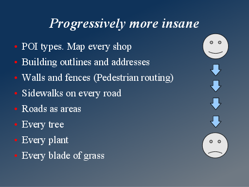
‘Blade of grass’ almost sounds like a metaphor for a type of feature that contributes a level of detail that no one - not even one with an eidetic memory - could recall. If that is true for grass, then a more reasonable representation for the plant might be using a crown shape like for trees. :)
Comment from GinaroZ on 21 August 2020 at 20:50
Edinburgh’s level of detail comes from having excellent out of copyright OS maps available to trace from, along with some good surveying. Most places don’t have that combination so there’s not that kind of detail mapped on a city scale, just in smaller pockets carried out by enthusiastic mappers.
Fortunately we now have better quality Bing imagery to help with that kind of detailed mapping. However, the issue is that it seems to be slightly misaligned with the old Bing imagery (which I think is now used for the ESRI clarity imagery layer). So that might cause a problem if mappers don’t correct the alignment before making changes!